450:
fishing, he discovered that he had forgotten to bring his key. When he returned home, the selkie wife had escaped back to sea, leaving their children behind. Later, when the farmer was out on a hunt, he killed both her selkie husband and two selkie sons, and she promised to take revenge upon the men of
Mikladalur. Some shall be drowned, some shall fall from cliffs and slopes, and this shall continue, until so many men have been lost that they will be able to link arms around the whole island of Kalsoy; occasional deaths still occur in this way on the island.
52:
390:
743:
40:
428:
382:
418:
to both settlements. One can walk north all the way to the lighthouse at Kallur but the four unlit tunnels on the way make carrying a torch advisable. Traffic is insufficient to pose problems with exhaust gases. The northernmost tunnel through to Trøllanes is narrow, cold, damp, and over 2 km
449:
A young farmer from the town of
Mikladalur on Kalsoy Island went to the beach to watch the selkies dance. He hid the skin of a beautiful selkie maid, so she could not go back to sea, and forced her to marry him. He kept her skin in a chest and the key with him both day and night. One day when out
453:
This revenge has always been taken seriously, not only in Kalsoy, but also in the Faroe
Islands generally. The descendants of the Seal-Woman are still known in the country by certain characteristics, especially their short fingers.
419:
long. It is rarely used by vehicles since the population of Trøllanes is only 20. The alternative overland route from
Mikladalur to Trøllanes is a dangerous and precipitous path that is best avoided.
623:
767:
295:. In the film, which was released in 2021, the villain's lair is located on the island, for which a harbour and missile silos were added digitally.
314:
The western coast has steep cliffs for the full length of the island, whereas valleys on the eastern slopes protect the four tiny settlements,
616:
555:
762:
609:
51:
632:
331:
65:
30:
480:
545:
742:
537:
330:, whose combined populations total less than 80. They are connected by a partly surfaced road which
97:
402:
The island has 13 peaks, the two highest of which are
Nestindar (787 m) and Botnstindur (743 m).
687:
359:
371:
217:
206:
8:
355:
196:
497:
BirdLife
International. (2012). Important Bird Areas factsheet: Kalsoy. Downloaded from
39:
102:
541:
707:
682:
563:
335:
274:; by contrast with the parallel island to the east, Kunoy, the name of which means
389:
375:
367:
247:
334:. The island's thin shape and road tunnels give it the nickname "the recorder" (
601:
595:
291:
756:
636:
282:
255:
112:
80:
67:
323:
354:
The northern and western coastline of the island has been identified as an
327:
281:
The northernmost part and scenery of Kalsoy was used as stand-in for the
415:
122:
343:
319:
286:
717:
442:
Kalsoy has many legends, the best known of which is the legend of the
578:
511:
410:
Ferry landings occur at Syðradalur, and one of the mail boats (named
187:
722:
702:
692:
647:
302:, is a comparatively isolated island, in that no bridge, tunnel, or
299:
712:
652:
303:
263:
242:
732:
727:
315:
363:
259:
697:
672:
662:
657:
443:
213:
192:
677:
590:
427:
267:
381:
498:
422:
Bus service between Húsar and Trøllanes also is provided.
393:
The
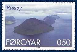
Kalsoyarfjørður with Kalsoy (left) and Kunoy (right)
577:some material on this page was translated from the
362:because of its significance as a breeding site for
346:is located at Kallur, the northern tip of Kalsoy.
754:
631:
617:
285:in eastern Russia while filming for the 25th
16:Island in Faroe Islands, Kingdom of Denmark
624:
610:
534:Iceland, Greenland & the Faroe Islands
768:Important Bird Areas of the Faroe Islands
426:
388:
380:
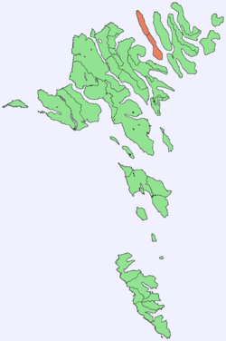
254:) is an island in the north-east of the
755:
531:
349:
605:
241:
556:"Norðoyggjar - The Northern Islands"
514:. Sjoferdir Skúvadal (www.puffin.fo)
137:30.9 km (11.9 sq mi)
13:
579:Kalsoy article on German Knowledge
481:"James Bond Faroe Islands scenery"
14:
779:
584:
56:Location within the Faroe Islands
741:
560:Faroe Islands Tourist Guide 2005
332:passes through four dark tunnels
50:
38:
598:with 6 aerial photos of Kalsoy
512:"The seal-woman of Mikladalur"
504:
491:
473:
464:
1:
532:Swaney, Deanna (June 1997) .
457:
446:or Seal-Woman of Mikladalur.
763:Islands of the Faroe Islands
397:
309:
7:
414:) makes regular trips from
10:
784:
538:Lonely Planet Publications
437:
153:787 m (2,582 ft)
739:
643:
405:
224:
203:
186:
178:
170:
162:
157:
149:
141:
133:
128:
118:
108:
96:
61:
49:
37:
28:
21:
499:http://www.birdlife.org
182:2.5/km (6.4/sq mi)
562:. 2005. Archived from
485:Guide to Faroe Islands
432:
394:
386:
372:European storm petrels
360:BirdLife International
339:
251:
239:Faroese pronunciation:
150:Highest elevation
430:
392:
385:Kalsoy, western coast
384:
205: • Summer (
179: • Density
470:en.m.wiktionary.org
356:important bird area
350:Important bird area
109:Constituent country
77: /
433:
395:
387:
374:(5000 pairs), and
163: • Total
134: • Total
103:Kingdom of Denmark
750:
749:
270:. The name means
243:[ˈkalsɔɪ]
232:
231:
171: • Rank
142: • Rank
119:Municipality seat
775:
745:
626:
619:
612:
603:
602:
596:Personal website
574:
572:
571:
551:
536:(3rd ed.).
524:
523:
521:
519:
508:
502:
495:
489:
488:
477:
471:
468:
376:black guillemots
370:(40,000 pairs),
368:Atlantic puffins
245:
240:
210:
92:
91:
89:
88:
87:
82:
81:62.283°N 6.733°W
78:
75:
74:
73:
70:
54:
42:
19:
18:
783:
782:
778:
777:
776:
774:
773:
772:
753:
752:
751:
746:
737:
639:
630:
591:Tourism website
587:
569:
567:
554:
548:
528:
527:
517:
515:
510:
509:
505:
496:
492:
479:
478:
474:
469:
465:
460:
440:
435:
434:
408:
400:
352:
312:
238:
204:
85:
83:
79:
76:
71:
68:
66:
64:
63:
57:
45:
33:
24:
17:
12:
11:
5:
781:
771:
770:
765:
748:
747:
740:
738:
736:
735:
730:
725:
720:
715:
710:
705:
700:
695:
690:
685:
680:
675:
670:
665:
660:
655:
650:
644:
641:
640:
629:
628:
621:
614:
606:
600:
599:
593:
586:
585:External links
583:
582:
581:
575:
552:
546:
526:
525:
503:
501:on 2012-02-23.
490:
472:
462:
461:
459:
456:
439:
436:
425:
424:
407:
404:
399:
396:
351:
348:
311:
308:
292:No Time to Die
230:
229:
226:
222:
221:
211:
201:
200:
190:
184:
183:
180:
176:
175:
172:
168:
167:
164:
160:
159:
155:
154:
151:
147:
146:
143:
139:
138:
135:
131:
130:
126:
125:
120:
116:
115:
110:
106:
105:
100:
94:
93:
86:62.283; -6.733
59:
58:
55:
47:
46:
43:
35:
34:
29:
26:
25:
22:
15:
9:
6:
4:
3:
2:
780:
769:
766:
764:
761:
760:
758:
744:
734:
731:
729:
726:
724:
721:
719:
716:
714:
711:
709:
706:
704:
701:
699:
696:
694:
691:
689:
686:
684:
681:
679:
676:
674:
671:
669:
666:
664:
661:
659:
656:
654:
651:
649:
646:
645:
642:
638:
637:Faroe Islands
634:
627:
622:
620:
615:
613:
608:
607:
604:
597:
594:
592:
589:
588:
580:
576:
566:on 2006-05-08
565:
561:
557:
553:
549:
547:0-86442-453-1
543:
539:
535:
530:
529:
513:
507:
500:
494:
486:
482:
476:
467:
463:
455:
451:
447:
445:
431:Map of Kalsoy
429:
423:
420:
417:
413:
403:
391:
383:
379:
378:(200 pairs).
377:
373:
369:
366:, especially
365:
361:
357:
347:
345:
341:
337:
333:
329:
325:
321:
317:
307:
306:links to it.
305:
301:
298:Kalsoy, like
296:
294:
293:
288:
284:
283:Kuril Islands
279:
277:
273:
269:
265:
261:
257:
256:Faroe Islands
253:
249:
244:
236:
227:
223:
219:
215:
212:
208:
202:
198:
194:
191:
189:
185:
181:
177:
173:
169:
165:
161:
156:
152:
148:
144:
140:
136:
132:
127:
124:
121:
117:
114:
113:Faroe Islands
111:
107:
104:
101:
99:
95:
90:
62:Coordinates:
60:
53:
48:
41:
36:
32:
27:
20:
667:
568:. Retrieved
564:the original
559:
533:
516:. Retrieved
506:
493:
484:
475:
466:
452:
448:
441:
421:
411:
409:
401:
353:
340:blokkfloytan
313:
297:
290:
280:
276:woman island
275:
271:
234:
233:
225:Calling code
708:Stóra Dímun
683:Lítla Dímun
84: /
757:Categories
570:2006-07-16
518:6 November
458:References
344:lighthouse
324:Syðradalur
320:Mikladalur
287:James Bond
272:man island
158:Population
398:Mountains
328:Trøllanes
310:Geography
188:Time zone
713:Streymoy
653:Eysturoy
416:Klaksvík
364:seabirds
304:causeway
264:Eysturoy
262:between
123:Klaksvík
718:Suðuroy
688:Mykines
635:of the
633:Islands
438:Legends
336:Faroese
260:Denmark
69:62°17′N
723:Svínoy
703:Skúvoy
698:Sandoy
693:Nólsoy
673:Koltur
668:Kalsoy
663:Hestur
658:Fugloy
648:Borðoy
544:
444:Selkie
406:Travel
342:). A
326:, and
300:Svínoy
289:movie
248:Danish
235:Kalsoy
72:6°44′W
44:Kalsoy
31:Island
23:Kalsoy
733:Viðoy
728:Vágar
678:Kunoy
316:Húsar
268:Kunoy
252:Kalsø
214:UTC+1
193:UTC+0
98:State
542:ISBN
520:2013
266:and
129:Area
412:Sam
358:by
258:of
228:298
218:EST
207:DST
197:GMT
759::
558:.
540:.
483:.
338::
322:,
318:,
278:.
250::
246:,
166:76
625:e
618:t
611:v
573:.
550:.
522:.
487:.
237:(
220:)
216:(
209:)
199:)
195:(
174:9
145:9
Text is available under the Creative Commons Attribution-ShareAlike License. Additional terms may apply.

