56:
295:. The length of the Iput is 437 kilometres (272 mi). The area of its basin is 10,900 square kilometres (4,200 sq mi). The Iput freezes over in late November and stays icebound until late March to early April. Its main tributaries are the
421:
334:, and flows south downstream of Yershichi. A stretch of the Iput, flowing southwest, makes a border between Smolensk Oblast (Yershichsky District) and Bryansk Oblast (
112:
300:
296:
339:
323:
362:
and
Klintsovsky Districts. Downstream, it crosses the western part of Klintsovsky District, makes a border between Klintsovsky and
523:
343:
314:
The source of the Iput is in
Mogilev Region of Belarus. It flows east and enters Russia, where it makes the border between
354:. It further flows southwest through Surazhsky District and the town of Surazh and makes the border between Surazhsky and
498:
508:
518:
503:
528:
513:
533:
17:
458:
55:
377:
A stretch of the Iput 20 kilometres (12 mi) west of
Klintsy is a protected birds sanctuary.
176:
363:
342:
the Iput departs south of the border and flows south through
Kletnyansky District, accepts the
359:
355:
335:
319:
315:
8:
367:
255:
242:
35:
351:
399:
347:
192:
260:
43:
433:
280:
304:
284:
268:
492:
127:
114:
470:
454:
272:
93:
327:
331:
180:
394:
326:
it departs of the border and flows southeast, flowing through the
308:
276:
172:
81:
61:
288:
77:
370:
and flows to
Belarus. the mouth of the Iput is in the city of
371:
292:
168:
98:
490:
346:from the left, crosses the northern part of
322:of Smolensk Oblast. Close to the village of
350:and makes the border between Mglinsky and
436:(in Russian). Институт Озероведения РАН
14:
491:
473:(in Russian). Ecological Map of Russia
155:10,900 km (4,200 sq mi)
254:
24:
25:
545:
358:, and further downstream between
291:. It is a left tributary of the
54:
524:International rivers of Europe
463:
448:
434:"Гидрография Брянской области"
426:
415:
387:
249:, alternative transliteration
106: • coordinates
13:
1:
380:
338:). Downstream of the selo of
88:Physical characteristics
366:, crosses Novozybkovsky and
7:
10:
550:
499:Tributaries of the Dnieper
509:Rivers of Smolensk Oblast
459:Great Soviet Encyclopedia
402:Sites Information Service
311:are located on the Iput.
264:
246:
227:
223:
215:
207:
199:
190:
186:
164:
159:
151:
147:437 km (272 mi)
143:
104:
92:
87:
73:
68:
53:
47:
39:
32:
519:Rivers of Mogilev Region
504:Rivers of Bryansk Oblast
422:official transliteration
27:River in Russia, Belarus
529:Ramsar sites in Belarus
395:"Iput River Floodplain"
364:Novozybkovsky Districts
514:Rivers of Gomel Region
356:Klintsovsky Districts
320:Yershichsky Districts
203:Iput River Floodplain
128:52.42889°N 31.05111°E
368:Zlynkovsky Districts
336:Kletnyansky District
352:Surazhsky Districts
177:Dnieper–Bug estuary
160:Basin features
124: /
216:Reference no.
133:52.42889; 31.05111
534:Rivers of Belarus
348:Mglinsky District
256:[iput͡sʲ]
231:
230:
16:(Redirected from
541:
483:
482:
480:
478:
467:
461:
452:
446:
445:
443:
441:
430:
424:
419:
413:
412:
410:
408:
391:
267:) is a river in
266:
258:
248:
139:
138:
136:
135:
134:
129:
125:
122:
121:
120:
117:
58:
49:
41:
30:
29:
21:
549:
548:
544:
543:
542:
540:
539:
538:
489:
488:
487:
486:
476:
474:
469:
468:
464:
453:
449:
439:
437:
432:
431:
427:
420:
416:
406:
404:
393:
392:
388:
383:
303:. The towns of
285:Bryansk Oblasts
195:
132:
130:
126:
123:
118:
115:
113:
111:
110:
107:
64:
42:
34:
28:
23:
22:
15:
12:
11:
5:
547:
537:
536:
531:
526:
521:
516:
511:
506:
501:
485:
484:
462:
447:
425:
414:
385:
384:
382:
379:
229:
228:
225:
224:
221:
220:
217:
213:
212:
209:
205:
204:
201:
197:
196:
193:Ramsar Wetland
191:
188:
187:
184:
183:
166:
162:
161:
157:
156:
153:
149:
148:
145:
141:
140:
108:
105:
102:
101:
96:
90:
89:
85:
84:
75:
71:
70:
66:
65:
59:
51:
50:
26:
9:
6:
4:
3:
2:
546:
535:
532:
530:
527:
525:
522:
520:
517:
515:
512:
510:
507:
505:
502:
500:
497:
496:
494:
472:
466:
460:
456:
451:
435:
429:
423:
418:
403:
401:
396:
390:
386:
378:
375:
373:
369:
365:
361:
357:
353:
349:
345:
341:
337:
333:
329:
325:
321:
317:
312:
310:
306:
302:
298:
294:
290:
286:
282:
278:
274:
273:Gomel Regions
270:
262:
257:
252:
244:
240:
236:
226:
222:
218:
214:
211:30 March 2015
210:
206:
202:
200:Official name
198:
194:
189:
185:
182:
178:
174:
170:
167:
163:
158:
154:
150:
146:
142:
137:
109:
103:
100:
97:
95:
91:
86:
83:
79:
76:
72:
67:
63:
57:
52:
45:
37:
31:
19:
475:. Retrieved
471:"Река Ипуть"
465:
450:
438:. Retrieved
428:
417:
405:. Retrieved
398:
389:
376:
313:
250:
238:
234:
232:
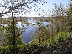
60:The Iput in
360:Gordeyevsky
316:Shumyachsky
165:Progression
131: /
493:Categories
477:31 January
440:31 January
381:References
243:Belarusian
208:Designated
152:Basin size
119:31°03′04″E
116:52°25′44″N
36:Belarusian
18:Iput River
332:Yershichi
297:Voronitsa
181:Black Sea
407:25 April
281:Smolensk
69:Location
340:Korsiki
324:Shadoga
309:Dobrush
277:Belarus
269:Mogilev
261:Russian
173:Dnieper
82:Belarus
74:Country
62:Dobrush
44:Russian
400:Ramsar
305:Surazh
301:Unecha
289:Russia
144:Length
78:Russia
455:Ипуть
372:Gomel
344:Nadva
265:Ипуть
247:Іпуць
239:Iputs
237:, or
94:Mouth
48:Ипуть
40:Іпуць
479:2018
442:2018
409:2018
328:selo
318:and
307:and
299:and
293:Sozh
283:and
279:and
271:and
251:Ipuć
235:Iput
233:The
219:2262
169:Sozh
99:Sozh
33:Iput
330:of
287:in
275:in
495::
457:,
397:.
374:.
263::
259:;
253:,
245::
179:→
175:→
171:→
80:,
46::
38::
481:.
444:.
411:.
241:(
20:)
Text is available under the Creative Commons Attribution-ShareAlike License. Additional terms may apply.
