187:
255:
period, the
Hamchang area was designated as Hamchang-hyeon in 1490 and Hamchang-gun (Hamchang County) in 1895. In 1914, it became known as Hamchang-myeon and was included in Sangju County. It received its present designation as Hamchang-eup by presidential decree on December 1, 1980.
244:
of Sangju. At this time, Hamchang was known by various names which appear to suggest a connection with
Goryeong Gaya, such as Goreung (고릉, 古陵), Gonyeong (고녕, 古寧), and Godongnam-gun (고동람군, 古冬欖郡).
126:), and has a population of 8,427 (from 2003 registration figures). There are two elementary schools, a middle school and a high school. Hamchang was once the capital of a small kingdom,
233:, a minor state which appears in early Silla records . What relation may have existed between Sabeol-guk and Goryeong Gaya, or whether they were in fact the same kingdom, is not known.
287:
218:
191:
162:. It covers a total area of 43.37 km². Of this 16.87 km² are vacant. The vacant land is mostly mountainous, but contains no high peaks;
171:
163:
155:
159:
174:
and
Hamchang-eup. The Iancheon stream runs from west to east across southern Hamchang and into the Yeong, which shortly thereafter meets the
230:
151:
123:
251:
period, in 964, the area became known as
Hamnyeong-gun (함녕군, 咸寧郡). The name changed to the present "Hamchang" in 1018. In the
265:
130:. Although its role today is far less central, it remains an important local town, served by intercity buses as well as the
225:
lineage, is located near the town center. On Obong
Mountain, other tombs dating to the Three Kingdoms period have been
70:
17:
210:
is traditionally supposed to have been based in
Hamchang, making it by far the northernmost state of the
226:
199:
84:
8:
222:
142:
Hamchang is located about 19 kilometers north of the Sangju city center, and borders
211:
111:
166:
itself stands a mere 192 meters high. Hamchang's eastern border is formed by the
282:
252:
131:
150:
City directly on the north. Within Sangju, it adjoins the local districts of
276:
207:
175:
127:
167:
115:
75:
147:
203:
143:
186:
248:
236:
By the early 6th century, the
Hamchang area was securely under
107:
38:
237:
54:
240:
control. It was subsequently administered as part of the
89:
288:Towns and townships in North Gyeongsang Province
274:
221:, who is also the progenitor of the Hamchang
60:
44:
185:
229:. These are sometimes associated with
14:
275:
124:South Korean administrative division
24:
170:, which flows between Mungyeong's
25:
299:
259:
266:Official eup website, in Korean
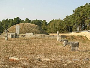
194:, in Hamchang-eup, Sangju City.
61:
45:
13:
1:
137:
118:. It comprises 30 distinct
7:
90:
76:
10:
304:
181:
83:
69:
53:
37:
32:
190:Tomb attributed to King
195:
192:Taejo of Goryeong Gaya
200:Three Kingdoms period
189:
217:The reputed tomb of
71:Revised Romanization
27:Place in South Korea
219:Goryeong's founder
196:
97:
96:
85:McCune–Reischauer
16:(Redirected from
295:
212:Gaya confederacy
112:North Gyeongsang
93:
79:
64:
63:
48:
47:
30:
29:
21:
303:
302:
298:
297:
296:
294:
293:
292:
273:
272:
262:
184:
140:
65:
49:
28:
23:
22:
15:
12:
11:
5:
301:
291:
290:
285:
269:
268:
261:
260:External links
258:
183:
180:
172:Yeongsun-myeon
164:Obong Mountain
156:Gonggeom-myeon
139:
136:
132:Gyeongbuk Line
122:(the smallest
95:
94:
87:
81:
80:
73:
67:
66:
59:
57:
51:
50:
43:
41:
35:
34:
26:
9:
6:
4:
3:
2:
300:
289:
286:
284:
281:
280:
278:
271:
267:
264:
263:
257:
254:
250:
245:
243:
239:
234:
232:
228:
224:
220:
215:
213:
209:
208:Goryeong Gaya
205:
201:
198:In the early
193:
188:
179:
177:
173:
169:
165:
161:
157:
153:
149:
145:
135:
133:
129:
128:Goryeong Gaya
125:
121:
117:
113:
109:
105:
101:
92:
88:
86:
82:
78:
74:
72:
68:
58:
56:
52:
42:
40:
36:
31:
19:
270:
246:
241:
235:
216:
202:, the small
197:
160:Sabeol-myeon
141:
119:
103:
99:
98:
91:Hamch'ang-Ŭp
77:Hamchang-eup
18:Hamchang-eup
168:Yeong River
116:South Korea
277:Categories
231:Sabeol-guk
134:railroad.
114:province,
227:excavated
152:Ian-myeon
148:Mungyeong
138:Geography
144:Jeomchon
100:Hamchang
33:Hamchang
247:In the
204:kingdom
182:History
176:Nakdong
283:Sangju
253:Joseon
249:Goryeo
158:, and
110:City,
108:Sangju
102:is an
39:Hangul
238:Silla
55:Hanja
223:Kim
206:of
146:in
106:in
104:eup
62:咸昌邑
46:함창읍
279::
242:ju
214:.
178:.
154:,
120:ri
20:)
Text is available under the Creative Commons Attribution-ShareAlike License. Additional terms may apply.
