45:
437:
61:
129:
68:
336:
took place here. The village was partly destroyed, and in the spring 1940, all residents of Głowaczów were forced to leave their houses, as German authorities built airforce training facilities. Its Jewish residents were murdered in late 1942 in
286:), and later on, it belonged to the families of Leżeński, Boski and Ostroróg. The town with its two churches (one from 1390, another from 1445) was destroyed by Swedish invaders in the
89:
305:(1815-1915). In the second half of the 17th century, Głowaczów emerged as a local center of Jewish culture. Here, on February 15, 1864, one of battles of the
657:
403:
44:
667:
521:
481:
586:
606:
396:
506:
566:
456:
314:
626:
571:
60:
17:
546:
591:
601:
556:
389:
501:
338:
220:
496:
636:
561:
516:
436:
451:
359:"Central Statistical Office (GUS) - TERYT (National Register of Territorial Land Apportionment Journal)"
228:
662:
611:
283:
358:
536:
471:
310:
295:
141:
121:
511:
199:
412:
309:
took place, and in 1869, the
Russians stripped it of its town charter. In 1921, already in
291:
259:
251:
209:
170:
146:
290:(1655). New church was built in 1675, to be destroyed by Germans in 1944. Until 1795 (see
8:
621:
631:
321:
576:
299:
306:
287:
247:
158:
551:
302:
243:
375:
651:
282:
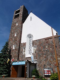
Głowaczów was founded in 1445 by a nobleman named Sędziwój Leżeński Głowacz (
263:
104:
91:
325:
466:
541:
333:
531:
491:
596:
476:
329:
267:
190:
486:
461:
581:
381:
616:
271:
216:
195:
153:
134:
526:
255:
165:
328:
in
September 1939, several skirmishes between the advancing
317:, Głowaczów had 2271 inhabitants, including 1411 Jews.
266:, approximately 18 kilometres (11 mi) west of
649:
254:, in east-central Poland. It is the seat of the
397:
404:
390:
298:, and in the 19th century, it was part of
294:), Głowaczów belonged to Lesser Poland's
16:For other places with the same name, see
658:Cities and towns in Masovian Voivodeship
262:. It lies in northern part of historic
650:
385:
270:and 71 km (44 mi) south of
351:
23:Town in Masovian Voivodeship, Poland
411:
13:
14:
679:
369:
258:(administrative district) called
67:
435:
242:
127:
66:
59:
43:
274:, along National Road Nr. 48.
1:
668:Holocaust locations in Poland
376:Jewish Community in Głowaczów
344:
339:Treblinka extermination camp
332:and the retreating units of
7:
10:
684:
277:
15:
444:
433:
419:
227:
206:
189:
181:
176:
164:
152:
140:
120:
85:
54:
42:
35:
28:
361:(in Polish). 2008-06-01.
311:Second Polish Republic
296:Sandomierz Voivodeship
208: • Summer (
49:Saint Lawrence Church
292:Partitions of Poland
252:Masovian Voivodeship
229:Vehicle registration
622:Studzianki Pancerne
512:Ignacówka Bobrowska
284:Nałęcz coat of arms
101: /
322:invasion of Poland
320:During the German
315:Kielce Voivodeship
300:Russian-controlled
182: • Total
645:
644:
472:Cecylówka-Brzózka
378:on Virtual Shtetl
237:
236:
105:51.617°N 21.317°E
675:
663:Kozienice County
439:
406:
399:
392:
383:
382:
363:
362:
355:
324:, which started
307:January Uprising
248:Kozienice County
245:
213:
133:
131:
130:
116:
115:
113:
112:
111:
106:
102:
99:
98:
97:
94:
70:
69:
63:
47:
26:
25:
683:
682:
678:
677:
676:
674:
673:
672:
648:
647:
646:
641:
577:Miejska Dąbrowa
440:
431:
415:
413:Gmina Głowaczów
410:
372:
367:
366:
357:
356:
352:
347:
303:Congress Poland
280:
260:Gmina Głowaczów
207:
128:
126:
109:
107:
103:
100:
95:
92:
90:
88:
87:
81:
80:
79:
78:
77:
76:
75:
71:
50:
38:
31:
24:
21:
12:
11:
5:
681:
671:
670:
665:
660:
643:
642:
640:
639:
634:
629:
624:
619:
614:
609:
604:
599:
594:
589:
584:
579:
574:
569:
564:
559:
554:
549:
544:
539:
534:
529:
524:
519:
514:
509:
504:
499:
494:
489:
484:
479:
474:
469:
464:
459:
454:
448:
446:
445:Other villages
442:
441:
434:
432:
430:
429:
423:
421:
417:
416:
409:
408:
401:
394:
386:
380:
379:
371:
370:External links
368:
365:
364:
349:
348:
346:
343:
279:
276:
235:
234:
231:
225:
224:
214:
204:
203:
193:
187:
186:
183:
179:
178:
174:
173:
168:
162:
161:
156:
150:
149:
144:
138:
137:
124:
118:
117:
110:51.617; 21.317
83:
82:
73:
72:
65:
64:
58:
57:
56:
55:
52:
51:
48:
40:
39:
36:
33:
32:
29:
22:
9:
6:
4:
3:
2:
680:
669:
666:
664:
661:
659:
656:
655:
653:
638:
635:
633:
632:Wólka Brzózka
630:
628:
625:
623:
620:
618:
615:
613:
610:
608:
605:
603:
600:
598:
595:
593:
590:
588:
585:
583:
580:
578:
575:
573:
570:
568:
565:
563:
560:
558:
555:
553:
552:Łukawska Wola
550:
548:
545:
543:
540:
538:
535:
533:
530:
528:
525:
523:
520:
518:
515:
513:
510:
508:
505:
503:
500:
498:
495:
493:
490:
488:
485:
483:
480:
478:
475:
473:
470:
468:
465:
463:
460:
458:
455:
453:
450:
449:
447:
443:
438:
428:
425:
424:
422:
418:
414:
407:
402:
400:
395:
393:
388:
387:
384:
377:
374:
373:
360:
354:
350:
342:
340:
335:
331:
327:
323:
318:
316:
312:
308:
304:
301:
297:
293:
289:
285:
275:
273:
269:
265:
264:Lesser Poland
261:
257:
253:
249:
246:is a town in
244:
241:
232:
230:
226:
222:
218:
215:
211:
205:
201:
197:
194:
192:
188:
184:
180:
175:
172:
169:
167:
163:
160:
157:
155:
151:
148:
145:
143:
139:
136:
125:
123:
119:
114:
86:Coordinates:
84:
62:
53:
46:
41:
34:
27:
19:
426:
353:
326:World War II
319:
281:
239:
238:
607:Stanisławów
557:Maciejowice
542:Lipska Wola
522:Klementynów
334:Armia Prusy
142:Voivodeship
108: /
652:Categories
587:Podmieście
492:Grabnowola
457:Bobrowniki
345:References
177:Population
637:Zieleniec
602:Sewerynów
562:Mariampol
517:Jasieniec
507:Ignacówka
467:Cecylówka
427:Głowaczów
330:Wehrmacht
268:Kozienice
240:Głowaczów
191:Time zone
171:Głowaczów
159:Kozienice
74:Głowaczów
30:Głowaczów
18:Głowaczów
592:Przejazd
582:Moniochy
572:Michałów
567:Marianów
532:Leżenice
502:Henryków
482:Dąbrówki
147:Masovian
627:Ursynów
617:Studnie
597:Rogożek
497:Helenów
477:Chodków
278:History
122:Country
96:21°19′E
93:51°37′N
612:Stawki
547:Łukawa
487:Emilów
462:Brzóza
452:Adamów
288:deluge
272:Warsaw
154:County
135:Poland
132:
527:Kosny
256:gmina
217:UTC+2
196:UTC+1
166:Gmina
537:Lipa
420:Seat
221:CEST
37:Town
313:’s
233:WKZ
210:DST
200:CET
185:780
654::
341:.
250:,
405:e
398:t
391:v
223:)
219:(
212:)
202:)
198:(
20:.
Text is available under the Creative Commons Attribution-ShareAlike License. Additional terms may apply.

