383:
567:
126:
151:
31:
158:
133:
369:
that have been faced in concrete. It is 17.5 feet (5.3 m) wide, with a roadway width of 15 feet (4.6 m) (one lane). The trusses have been strengthened by iron rods descending from the diagonals, and laminated stringers have been added below the deck, with steel cables criss-crossed between
373:
The bridge was built in 1845, and is the oldest of
Tunbridge's five bridges. It was given an extensive renovation in 1969, in which its exterior siding was replaced in a sympathetic manner to its original finish. Along with
399:
975:
1005:
995:
947:
409:
404:
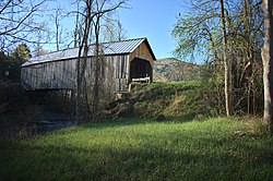
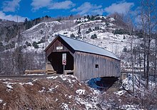
338:. Built in 1845, it is the oldest of five 19th-century covered bridges in Tunbridge, representing one of the highest concentrations of covered bridges in the state. It was listed on the
378:, the bridges in Tunbridge, each spanning the same river in a 7-mile (11 km) stretch, represent one of the highest concentrations of historic covered bridges in the state.
575:
990:
831:
523:
370:
the deck members to increase lateral stability. The sides and portal ends are finished in vertical board siding, and the bridge is covered by a gabled metal roof.
713:
1000:
382:
1010:
980:
628:
190:
491:
885:
951:
516:
791:
150:
896:
1015:
668:
509:
703:
125:
648:
608:
532:
437:
339:
107:
781:
693:
673:
45:
985:
970:
566:
678:
663:
623:
901:
741:
683:
501:
394:
918:
556:
890:
923:
38:
811:
726:
653:
544:
806:
880:
688:
598:
801:
658:
603:
496:
Flint Bridge, Spanning First Branch White River, Bicknell Hill Road, Tunbridge, Orange County, VT
350:
The Flint
Covered Bridge is located in far northern Tunbridge, just south of the town line with
870:
766:
751:
721:
633:
536:
476:
907:
855:
845:
839:
498:", 12 photos, 2 color transparencies, 7 data pages, 2 photo caption pages
464:
460:
442:
375:
331:
816:
698:
8:
875:
776:
731:
618:
771:
746:
335:
178:
88:
259:
796:
786:
756:
736:
355:
583:
351:
531:
912:
593:
400:
List of bridges documented by the
Historic American Engineering Record in Vermont
865:
327:
964:
821:
761:
638:
613:
354:, carrying Bicknell Hill Road over the First Branch White River just east of
205:
192:
60:
47:
362:
643:
495:
948:
National
Register of Historic Places listings in Orange County, Vermont
588:
410:
National
Register of Historic Places listings in Orange County, Vermont
359:
30:
976:
Covered bridges on the
National Register of Historic Places in Vermont
405:
List of bridges on the
National Register of Historic Places in Vermont
850:
1006:
Road bridges on the
National Register of Historic Places in Vermont
366:
432:
937:‡ This historic property also has portions in an adjacent state.
996:
National
Register of Historic Places in Orange County, Vermont
330:carrying Bicknell Hill Road over the First Branch
962:
991:Historic American Engineering Record in Vermont
1001:Buildings and structures in Tunbridge, Vermont
952:List of National Historic Landmarks in Vermont
1011:Queen post truss bridges in the United States
517:
732:Chandler Music Hall and Bethany Parish House
157:
132:
792:South Tunbridge Methodist Episcopal Church
524:
510:
461:"NRHP nomination for Flint Covered Bridge"
381:
345:
981:Covered bridges in Orange County, Vermont
365:, 87 feet (27 m) long, set on stone
108:U.S. National Register of Historic Places
669:South Newbury Village Historic District
963:
704:West Newbury Village Historic District
454:
452:
433:"National Register Information System"
427:
425:
747:Ely Boston & Maine Railroad Depot
699:Wells River Village Historic District
505:
458:
609:Brookfield Village Historic District
533:National Register of Historic Places
492:Historic American Engineering Record
438:National Register of Historic Places
340:National Register of Historic Places
694:Tunbridge Village Historic District
674:Strafford Village Historic District
449:
422:
13:
604:Bradford Village Historic District
14:
1027:
679:Thetford Center Historic District
664:Randolph Center Historic District
654:Newbury Village Historic District
624:Chelsea Village Historic District
485:
742:Congregational Church of Chelsea
565:
156:
149:
131:
124:
29:
684:Thetford Hill Historic District
395:List of Vermont covered bridges
1016:1845 establishments in Vermont
919:Thetford Center Covered Bridge
629:Depot Square Historic District
557:Justin Smith Morrill Homestead
254:
1:
727:Central Vermont Railway Depot
415:
165:Show map of the United States
924:Union Village Covered Bridge
7:
388:
10:
1032:
812:West Fairlee Center Church
986:Bridges completed in 1845
971:Wooden bridges in Vermont
942:
932:
891:Lyme–East Thetford Bridge
830:
807:Wells River Graded School
712:
574:
563:
543:
316:
311:
303:
298:
290:
282:
277:
273:
265:
253:NRHP reference
252:
244:
229:
221:
184:
174:
118:
114:
105:
98:
94:
84:
76:
37:
28:
21:
16:Covered bridge in Vermont
881:Kingsbury Covered Bridge
689:Thetford Hill State Park
599:Bayley Historic District
494:(HAER) No. VT-29, "
245:Architectural style
802:Waits River Schoolhouse
659:Oxbow Historic District
346:Description and history
342:on September 10, 1974.
871:Gifford Covered Bridge
767:Kimball Public Library
752:Fairlee Railroad Depot
722:Brock Hill Schoolhouse
634:Hayward and Kibby Mill
537:Orange County, Vermont
358:. It is a single-span
286:Queenpost Truss Bridge
908:Moxley Covered Bridge
902:Morey Memorial Bridge
886:Larkin Covered Bridge
856:Cilley Covered Bridge
846:Braley Covered Bridge
840:Bedell Covered Bridge
465:National Park Service
443:National Park Service
225:1 acre (0.40 ha)
206:43.94889°N 72.45861°W
861:Flint Covered Bridge
817:Harlie Whitcomb Farm
459:Henry, Hugh (1974).
324:Flint Covered Bridge
100:Flint Covered Bridge
23:Flint Covered Bridge
897:Mill Covered Bridge
876:Howe Covered Bridge
777:Marvin Newton House
376:a bridge in Chelsea
211:43.94889; -72.45861
202: /
140:Show map of Vermont
57: /
772:Newbury Town House
336:Tunbridge, Vermont
269:September 10, 1974
179:Tunbridge, Vermont
958:
957:
787:Post Mills Church
757:Fairlee Town Hall
737:Elwin Chase House
356:Vermont Route 110
320:
319:
61:43.949°N 72.459°W
1023:
584:Allis State Park
569:
526:
519:
512:
503:
502:
479:
477:photos from 1974
474:
472:
471:
456:
447:
446:
429:
385:
304:Construction end
256:
240:
238:
217:
216:
214:
213:
212:
207:
203:
200:
199:
198:
195:
166:
160:
159:
153:
141:
135:
134:
128:
72:
71:
69:
68:
67:
62:
58:
55:
54:
53:
50:
33:
19:
18:
1031:
1030:
1026:
1025:
1024:
1022:
1021:
1020:
961:
960:
959:
954:
938:
928:
913:Piermont Bridge
826:
782:Peabody Library
708:
594:Aloha Hive Camp
570:
561:
548:
546:
539:
530:
488:
483:
482:
469:
467:
457:
450:
445:. July 9, 2010.
431:
430:
423:
418:
391:
348:
278:Characteristics
248:Queenpost truss
236:
234:
210:
208:
204:
201:
196:
193:
191:
189:
188:
170:
169:
168:
167:
164:
163:
162:
161:
144:
143:
142:
139:
138:
137:
136:
110:
101:
66:43.949; -72.459
65:
63:
59:
56:
51:
48:
46:
44:
43:
24:
17:
12:
11:
5:
1029:
1019:
1018:
1013:
1008:
1003:
998:
993:
988:
983:
978:
973:
956:
955:
943:
940:
939:
936:
934:
930:
929:
927:
926:
921:
916:
910:
905:
899:
894:
888:
883:
878:
873:
868:
866:Foundry Bridge
863:
858:
853:
848:
843:
836:
834:
828:
827:
825:
824:
819:
814:
809:
804:
799:
797:Stratton's Inn
794:
789:
784:
779:
774:
769:
764:
759:
754:
749:
744:
739:
734:
729:
724:
718:
716:
710:
709:
707:
706:
701:
696:
691:
686:
681:
676:
671:
666:
661:
656:
651:
646:
641:
636:
631:
626:
621:
616:
611:
606:
601:
596:
591:
586:
580:
578:
572:
571:
564:
562:
560:
559:
553:
551:
541:
540:
529:
528:
521:
514:
506:
500:
499:
487:
486:External links
484:
481:
480:
448:
420:
419:
417:
414:
413:
412:
407:
402:
397:
390:
387:
347:
344:
328:covered bridge
326:is a historic
318:
317:
314:
313:
309:
308:
305:
301:
300:
296:
295:
292:
288:
287:
284:
280:
279:
275:
274:
271:
270:
267:
263:
262:
257:
250:
249:
246:
242:
241:
231:
227:
226:
223:
219:
218:
186:
182:
181:
176:
172:
171:
155:
154:
148:
147:
146:
145:
130:
129:
123:
122:
121:
120:
119:
116:
115:
112:
111:
106:
103:
102:
99:
96:
95:
92:
91:
86:
82:
81:
78:
74:
73:
41:
35:
34:
26:
25:
22:
15:
9:
6:
4:
3:
2:
1028:
1017:
1014:
1012:
1009:
1007:
1004:
1002:
999:
997:
994:
992:
989:
987:
984:
982:
979:
977:
974:
972:
969:
968:
966:
953:
949:
946:
941:
935:
931:
925:
922:
920:
917:
914:
911:
909:
906:
903:
900:
898:
895:
892:
889:
887:
884:
882:
879:
877:
874:
872:
869:
867:
864:
862:
859:
857:
854:
852:
849:
847:
844:
841:
838:
837:
835:
833:
829:
823:
822:Wildwood Hall
820:
818:
815:
813:
810:
808:
805:
803:
800:
798:
795:
793:
790:
788:
785:
783:
780:
778:
775:
773:
770:
768:
765:
763:
762:Goshen Church
760:
758:
755:
753:
750:
748:
745:
743:
740:
738:
735:
733:
730:
728:
725:
723:
720:
719:
717:
715:
711:
705:
702:
700:
697:
695:
692:
690:
687:
685:
682:
680:
677:
675:
672:
670:
667:
665:
662:
660:
657:
655:
652:
650:
649:Asa May House
647:
645:
642:
640:
639:Lanakila Camp
637:
635:
632:
630:
627:
625:
622:
620:
617:
615:
614:Camp Billings
612:
610:
607:
605:
602:
600:
597:
595:
592:
590:
587:
585:
582:
581:
579:
577:
573:
568:
558:
555:
554:
552:
550:
542:
538:
534:
527:
522:
520:
515:
513:
508:
507:
504:
497:
493:
490:
489:
478:
466:
462:
455:
453:
444:
440:
439:
434:
428:
426:
421:
411:
408:
406:
403:
401:
398:
396:
393:
392:
386:
384:
379:
377:
371:
368:
364:
361:
357:
353:
343:
341:
337:
333:
329:
325:
315:
310:
306:
302:
297:
293:
289:
285:
281:
276:
272:
268:
266:Added to NRHP
264:
261:
258:
251:
247:
243:
232:
228:
224:
220:
215:
187:
183:
180:
177:
173:
152:
127:
117:
113:
109:
104:
97:
93:
90:
87:
83:
79:
75:
70:
42:
40:
36:
32:
27:
20:
944:
860:
468:. Retrieved
436:
380:
372:
363:truss bridge
349:
334:in northern
323:
321:
644:Mari-Castle
332:White River
209: /
185:Coordinates
80:Automobiles
64: /
39:Coordinates
965:Categories
832:Structures
619:Camp Wyoda
589:Aloha Camp
470:2016-08-18
416:References
197:72°27′31″W
194:43°56′56″N
52:72°27′32″W
49:43°56′56″N
945:See also:
933:Footnotes
851:Bridge 22
714:Buildings
576:Districts
367:abutments
360:Queenpost
89:Tunbridge
549:Landmark
547:Historic
545:National
389:See also
312:Location
291:Material
260:74000239
175:Location
352:Chelsea
299:History
235: (
77:Carries
283:Design
85:Locale
475:with
230:Built
950:and
322:The
307:1845
294:Wood
237:1845
233:1845
222:Area
535:in
255:No.
967::
463:.
451:^
441:.
435:.
424:^
915:‡
904:‡
893:‡
842:‡
525:e
518:t
511:v
473:.
239:)
Text is available under the Creative Commons Attribution-ShareAlike License. Additional terms may apply.


