643:"}},"text\/plain":{"en":{"":"inception"}}},"{\"value\":{\"time\":\"+2004-01-01T00:00:00Z\",\"timezone\":0,\"before\":0,\"after\":0,\"precision\":9,\"calendarmodel\":\"http:\\\/\\\/www.wikidata.org\\\/entity\\\/Q1985727\"},\"type\":\"time\"}":{"text\/html":{"en":{"P571":"2004"}},"text\/plain":{"en":{"P571":"2004"}}}}": -->
323:
276:
329:
72:
582:"}},"text\/plain":{"en":{"P275":"Creative Commons Attribution-ShareAlike 3.0 Unported"}}},"{\"value\":{\"entity-type\":\"item\",\"numeric-id\":50829104,\"id\":\"Q50829104\"},\"type\":\"wikibase-entityid\"}":{"text\/html":{"en":{"P275":"
334:
578:"}},"text\/plain":{"en":{"":"copyright license"}}},"{\"value\":{\"entity-type\":\"item\",\"numeric-id\":14946043,\"id\":\"Q14946043\"},\"type\":\"wikibase-entityid\"}":{"text\/html":{"en":{"P275":"
534:"}},"text\/plain":{"en":{"":"copyright status"}}},"{\"value\":{\"entity-type\":\"item\",\"numeric-id\":50423863,\"id\":\"Q50423863\"},\"type\":\"wikibase-entityid\"}":{"text\/html":{"en":{"P6216":"
487:"}},"text\/plain":{"en":{"":"depicts"}}},"{\"value\":{\"entity-type\":\"item\",\"numeric-id\":1536323,\"id\":\"Q1536323\"},\"type\":\"wikibase-entityid\"}":{"text\/html":{"en":{"P180":"
530:
887:
43:
395:– You must give appropriate credit, provide a link to the license, and indicate if changes were made. You may do so in any reasonable manner, but not in any way that suggests the licensor endorses you or your use.
197:
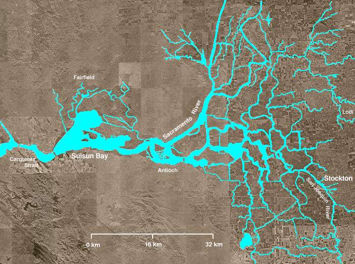
Several other open areas in the right half of the image are "islands," many of which have elevations well below sea level. Waterways (in blue) are clearly visible, as are fields and croplands (which appear as
583:
579:
535:
488:
449:
531:
640:
575:
484:
817:
173:, then turns south, meandering among several delta sloughs and waterways, ultimately flowing into the San Joaquin River in the center of the delta, northeast of
293:
83:
51:
586:"}},"text\/plain":{"en":{"P275":"GNU Free Documentation License, version 1.2 or later"}}}}": -->
291:; with no Invariant Sections, no Front-Cover Texts, and no Back-Cover Texts. A copy of the license is included in the section entitled
249:
626:
609:
561:
784:
517:
925:
This file contains additional information, probably added from the digital camera or scanner used to create or digitize it.
491:"}},"text\/plain":{"en":{"P180":"Sacramento-San Joaquin River Delta"}}}}": -->
402:
458:
118:
799:
545:
737:
283:
650:
593:
501:
203:
343:
174:
928:
If the file has been modified from its original state, some details may not fully reflect the modified file.
288:
718:
713:
143:
42:
401:– If you remix, transform, or build upon the material, you must distribute your contributions under the
166:
135:
538:"}},"text\/plain":{"en":{"P6216":"copyrighted"}}}}": -->
765:
The following pages on the
English Knowledge use this file (pages on other projects are not listed):
170:
91:
191:
139:
416:
281:
Permission is granted to copy, distribute and/or modify this document under the terms of the
147:
789:
769:
340:
151:
8:
230:
779:
749:
267:, the copyright holder of this work, hereby publishes it under the following license:
155:
78:
194:, where pumps lift water to be sent southward in the California Water Project canal.
794:
774:
741:
162:
361:
264:
753:
729:
842:
745:
660:
620:
603:
555:
511:
146:
from the south. The San
Joaquin and Sacramento rivers meet just west of
123:
897:
357:
260:
199:
867:
231:
http://en.wikipedia.org/Image:Wpdms_usgs_photo_sacramento_delta_2.jpg
857:
270:
686:
Click on a date/time to view the file as it appeared at that time.
847:
827:
877:
837:
415:
This licensing tag was added to this file as part of the GFDL
190:
The "lake-like" body of water near the bottom of the image is
902:
66:
450:
California
Grizzly Bear walking in the Delta Region.jpg
912:
763:
808:
684:
627:
610:
Creative
Commons Attribution-ShareAlike 3.0 Unported
584:
580:
Creative
Commons Attribution-ShareAlike 3.0 Unported
477:
The
Sacramento-San Joaquin River Delta of California
287:, Version 1.2 or any later version published by the
90:
Commons is a freely licensed media file repository.
220:
56:(700 × 520 pixels, file size: 81 KB, MIME type:
422:http://creativecommons.org/licenses/by-sa/3.0/
71:
322:
244:
216:
169:, picks up several tributaries including the
150:and their confluence continues westward into
108:
444:
428:Creative Commons Attribution-Share Alike 3.0
236:
226:
14:
378:– to copy, distribute and transmit the work
165:enters from the east, flows northwest from
740:covers the right half of this image. The
810:The following other wikis use this file:
126:- covering the right half of the map.
111:Wpdms usgs photo sacramento delta 2.jpg
52:Wpdms_usgs_photo_sacramento_delta_2.jpg
459:en:Sacramento-San Joaquin River Delta
448:Derivative works of this file:
102:
344:Attribution-Share Alike 3.0 Unported
317:
299:http://www.gnu.org/copyleft/fdl.html
800:Stockton Deepwater Shipping Channel
677:
333:
328:
13:
923:
888:സാക്രമെൻറോ-സാൻ ജോയക്വിൻ നദി ഡെൽറ്റ
843:Sacramento-San Joaquin River Delta
785:Sacramento–San Joaquin River Delta
738:Sacramento-San Joaquin River Delta
518:Sacramento-San Joaquin River Delta
489:Sacramento-San Joaquin River Delta
482:
476:
258:
119:Sacramento-San Joaquin River Delta
103:
49:
949:
930:
481:
764:
467:
389:Under the following conditions:
339:This file is licensed under the
332:
327:
321:
275:
274:
70:
31:
21:
736:{{Information |Description=The
464:
202:), and urban areas (especially
46:No higher resolution available.
805:
681:
463:
305:GNU Free Documentation License
294:GNU Free Documentation License
284:GNU Free Documentation License
26:
1:
36:
760:
497:Items portrayed in this file
7:
920:
898:Sacramento-San Joaquindelta
824:Usage on bar.wikipedia.org
814:Usage on azb.wikipedia.org
10:
954:
909:Usage on www.wikidata.org
894:Usage on nl.wikipedia.org
884:Usage on ml.wikipedia.org
874:Usage on it.wikipedia.org
864:Usage on eu.wikipedia.org
854:Usage on es.wikipedia.org
834:Usage on de.wikipedia.org
403:same or compatible license
105:
868:Ibai delta alderantzikatu
678:
348:
320:
16:
466:
289:Free Software Foundation
77:This is a file from the
41:
858:Delta fluvial invertido
748:from the north and the
735:
219:
142:from the north and the
81:. Information from its
158:(both on left of map).
84:description page there
752:from the south. The
192:Clifton Court Forebay
878:Delta del Sacramento
818:استوکتون، کالیفورنیا
790:Stockton, California
770:Inverted river delta
714:03:21, 8 August 2008
384:– to adapt the work
941:
940:
838:San Joaquin River
806:Global file usage
780:Restore the Delta
758:
750:San Joaquin River
594:copyright license
576:copyright license
475:
455:
454:
439:
438:
358:English Knowledge
316:
315:
261:English Knowledge
253:
250:Reusing this file
144:San Joaquin River
99:
98:
79:Wikimedia Commons
32:Global file usage
945:
931:
903:Omgekeerde delta
848:Carquinez-Straße
795:Stockton Channel
775:Port of Stockton
742:Sacramento River
726:
688:
546:copyright status
532:copyright status
473:
435:
432:
429:
426:
423:
420:
417:licensing update
405:as the original.
365:
364:
341:Creative Commons
336:
335:
331:
330:
325:
324:
318:
312:
309:
306:
303:
300:
278:
277:
271:
247:
222:
156:Carquinez Strait
136:Sacramento River
112:
106:
95:
74:
73:
67:
61:
59:
953:
952:
948:
947:
946:
944:
943:
942:
919:
828:Carquinez-Stroß
804:
766:
759:
754:Mokelumne River
744:flows into the
732:
724:
680:
679:
676:
675:
674:
673:
672:
671:
670:
669:
667:
657:
656:
655:
653:
638:
637:
636:
635:
634:
633:
632:
631:
629:
618:
617:
616:
615:
614:
612:
600:
599:
598:
596:
573:
572:
571:
570:
569:
568:
567:
566:
564:
552:
551:
550:
548:
529:
528:
527:
526:
525:
524:
523:
522:
520:
508:
507:
506:
504:
480:
479:
478:
456:
440:
433:
430:
427:
424:
421:
414:
355:
353:
310:
307:
304:
301:
298:
269:
268:
163:Mokelumne River
138:flows into the
110:
101:
100:
89:
88:
87:is shown below.
63:
57:
55:
48:
47:
12:
11:
5:
951:
939:
938:
935:
922:
918:
917:
916:
915:
907:
906:
905:
900:
892:
891:
890:
882:
881:
880:
872:
871:
870:
862:
861:
860:
852:
851:
850:
845:
840:
832:
831:
830:
822:
821:
820:
807:
803:
802:
797:
792:
787:
782:
777:
772:
762:
757:
756:
734:
730:
727:
721:
716:
711:
707:
706:
703:
700:
697:
694:
691:
683:
668:
665:
663:
662:
661:
659:
658:
654:
649:
647:
646:
645:
644:
642:
630:
625:
623:
622:
621:
619:
613:
608:
606:
605:
604:
602:
601:
597:
592:
590:
589:
588:
587:
585:
581:
577:
565:
560:
558:
557:
556:
554:
553:
549:
544:
542:
541:
540:
539:
537:
533:
521:
516:
514:
513:
512:
510:
509:
505:
500:
498:
495:
494:
493:
492:
490:
486:
472:
471:
468:
465:
453:
452:
446:
445:Other versions
442:
441:
437:
436:
411:
410:
409:
408:
407:
406:
396:
387:
386:
385:
379:
372:You are free:
367:
366:
350:
349:
347:
337:
314:
313:
279:
257:
256:
254:
242:
241:
238:
234:
233:
228:
224:
223:
218:
214:
213:
212:
211:
210:
209:
208:
207:
195:
183:
182:
181:
180:
179:
178:
171:Cosumnes River
159:
113:
104:
97:
96:
75:
65:
64:
45:
40:
39:
34:
29:
24:
19:
9:
6:
4:
3:
2:
950:
936:
933:
932:
929:
926:
914:
911:
910:
908:
904:
901:
899:
896:
895:
893:
889:
886:
885:
883:
879:
876:
875:
873:
869:
866:
865:
863:
859:
856:
855:
853:
849:
846:
844:
841:
839:
836:
835:
833:
829:
826:
825:
823:
819:
816:
815:
813:
812:
811:
801:
798:
796:
793:
791:
788:
786:
783:
781:
778:
776:
773:
771:
768:
767:
755:
751:
747:
743:
739:
733:
728:
722:
720:
717:
715:
712:
709:
708:
704:
701:
698:
695:
692:
690:
689:
687:
664:
652:
648:
628:
624:
611:
607:
595:
591:
563:
559:
547:
543:
519:
515:
503:
499:
496:
469:
462:
461:
460:
451:
447:
443:
418:
413:
412:
404:
400:
397:
394:
391:
390:
388:
383:
380:
377:
374:
373:
371:
370:
369:
368:
363:
359:
354:Attribution:
352:
351:
345:
342:
338:
326:
319:
296:
295:
290:
286:
285:
280:
273:
272:
266:
262:
255:
251:
246:
243:
240:Matthew Trump
239:
235:
232:
229:
225:
215:
205:
201:
196:
193:
189:
188:
187:
186:
185:
184:
176:
172:
168:
164:
160:
157:
154:and then the
153:
149:
145:
141:
137:
133:
132:
131:
130:
129:
128:
127:
125:
121:
120:
114:
107:
93:
86:
85:
80:
76:
69:
68:
62:
53:
44:
38:
35:
33:
30:
28:
25:
23:
20:
18:
15:
927:
924:
809:
685:
682:File history
457:
425:CC BY-SA 3.0
398:
392:
381:
375:
292:
282:
117:
115:
92:You can help
82:
50:
22:File history
562:copyrighted
536:copyrighted
399:share alike
393:attribution
109:Description
934:_error
761:File usage
731:Captndelta
723:700 × 520
699:Dimensions
245:Permission
152:Suisun Bay
124:California
58:image/jpeg
27:File usage
696:Thumbnail
693:Date/Time
651:inception
641:inception
362:Decumanus
346:license.
265:Decumanus
200:patchwork
921:Metadata
913:Q1536323
470:Captions
382:to remix
376:to share
204:Stockton
37:Metadata
725:(81 KB)
710:current
705:Comment
502:depicts
485:depicts
474:English
175:Antioch
148:Antioch
54:
237:Author
227:Source
746:delta
360:user
263:user
140:delta
702:User
666:2004
434:true
431:true
311:true
308:true
302:GFDL
221:2004
217:Date
167:Lodi
161:The
134:The
116:The
17:File
122:of
206:).
937:0
419:.
356:
297:.
259:
252:)
248:(
177:.
94:.
60:)
Text is available under the Creative Commons Attribution-ShareAlike License. Additional terms may apply.