597:"}},"text\/plain":{"en":{"":"coordinates of the point of view"}}},"{\"value\":{\"latitude\":39.313117,\"longitude\":-80.033619,\"altitude\":null,\"precision\":1.0e-6,\"globe\":\"http:\\\/\\\/www.wikidata.org\\\/entity\\\/Q2\"},\"type\":\"globecoordinate\"}":{"text\/html":{"en":{"P1259":"39\u00b018'47.221"N, 80\u00b02'1.028"W"}},"text\/plain":{"en":{"P1259":"39\u00b018'47.221\"N, 80\u00b02'1.028\"W"}}}}": -->
133:
335:
559:"}},"text\/plain":{"en":{"":"inception"}}},"{\"value\":{\"time\":\"+1995-10-01T00:00:00Z\",\"timezone\":0,\"before\":0,\"after\":0,\"precision\":11,\"calendarmodel\":\"http:\\\/\\\/www.wikidata.org\\\/entity\\\/Q1985727\"},\"type\":\"time\"}":{"text\/html":{"en":{"P571":"1 October 1995"}},"text\/plain":{"en":{"P571":"1 October 1995"}}}}": -->
43:
367:
459:
257:
95:
479:"}},"text\/plain":{"en":{"":"determination method"}}},"{\"value\":{\"entity-type\":\"item\",\"numeric-id\":60671452,\"id\":\"Q60671452\"},\"type\":\"wikibase-entityid\"}":{"text\/html":{"en":{"P459":"
475:"}},"text\/plain":{"en":{"P1001":"United States of America"}}},"{\"value\":{\"entity-type\":\"property\",\"numeric-id\":459,\"id\":\"P459\"},\"type\":\"wikibase-entityid\"}":{"text\/html":{"en":{"":"
635:"}},"text\/plain":{"en":{"":"location of creation"}}},"{\"value\":{\"entity-type\":\"item\",\"numeric-id\":511095,\"id\":\"Q511095\"},\"type\":\"wikibase-entityid\"}":{"text\/html":{"en":{"P1071":"
471:"}},"text\/plain":{"en":{"":"applies to jurisdiction"}}},"{\"value\":{\"entity-type\":\"item\",\"numeric-id\":30,\"id\":\"Q30\"},\"type\":\"wikibase-entityid\"}":{"text\/html":{"en":{"P1001":"
463:"}},"text\/plain":{"en":{"":"copyright status"}}},"{\"value\":{\"entity-type\":\"item\",\"numeric-id\":19652,\"id\":\"Q19652\"},\"type\":\"wikibase-entityid\"}":{"text\/html":{"en":{"P6216":"
467:"}},"text\/plain":{"en":{"P6216":"public domain"}}},"{\"value\":{\"entity-type\":\"property\",\"numeric-id\":1001,\"id\":\"P1001\"},\"type\":\"wikibase-entityid\"}":{"text\/html":{"en":{"":"
416:"}},"text\/plain":{"en":{"":"depicts"}}},"{\"value\":{\"entity-type\":\"item\",\"numeric-id\":7859833,\"id\":\"Q7859833\"},\"type\":\"wikibase-entityid\"}":{"text\/html":{"en":{"P180":"
631:
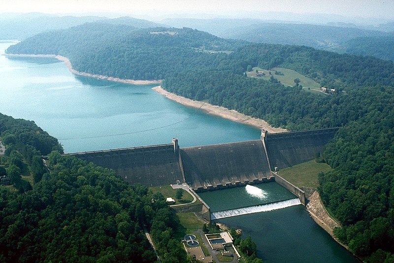
734:{{Information | Description = {{en|Tygart Lake and Dam on the Tygart River near the town of Grafton in Taylor County, West Virginia, USA. The U.S. Army Corps of Engineers constructed the dam on the Tygart River for flood control on the river. View is u
836:
177:
Tygart Lake and Dam on the Tygart River near the town of
Grafton in Taylor County, West Virginia, USA. The U.S. Army Corps of Engineers constructed the dam on the Tygart River for flood control on the river. View is upriver to the
364:
753:
358:
201:
480:
417:
636:
464:
632:
594:
468:
460:
556:
476:
413:
472:
61:
57:
53:
47:
106:
74:
483:"}},"text\/plain":{"en":{"P459":"work of the federal government of the United States"}}}}": -->
748:
224:
273:
541:
374:
446:
269:
140:
864:
This file contains additional information, probably added from the digital camera or scanner used to create or digitize it.
662:
187:
1 October 1995 (as given in the description, but the date is dubious considering the lack of autumn color in the landscape.)
506:
325:
646:
604:
519:
490:
566:
534:
430:
526:
420:"}},"text\/plain":{"en":{"P180":"Tygart River Reservoir Dam"}}}}": -->
867:
If the file has been modified from its original state, some details may not fully reflect the modified file.
265:
639:"}},"text\/plain":{"en":{"P1071":"Taylor County"}}}}": -->
716:
711:
65:
42:
744:
The following pages on the
English Knowledge use this file (pages on other projects are not listed):
114:
768:
308:
320:
316:
312:
304:
300:
296:
292:
288:
8:
773:
197:
758:
380:
149:
101:
268:
soldier or employee, taken or made as part of that person's official duties. As a
278:
754:
National
Register of Historic Places listings in Taylor County, West Virginia
656:
614:
576:
500:
440:
763:
727:
816:
791:
684:
Click on a date/time to view the file as it appeared at that time.
806:
366:
359:
39° 18′ 47.22″ N, 80° 02′ 01.03″ W
205:
826:
139:
This is an image of a place or building that is listed on the
144:
89:
796:
406:
Add a one-line explanation of what this file represents
851:
846:
742:
127:
79:(1,500 × 1,000 pixels, file size: 506 KB, MIME type:
782:
682:
113:
Commons is a freely licensed media file repository.
542:
work of the federal government of the United States
481:
work of the federal government of the United States
195:
U.S. Army Corps of
Engineers Digital Visual Library
94:
219:
215:Margaret Luzier, U.S. Army Corps of Engineers
183:
164:
749:List of dams and reservoirs in West Virginia
211:
191:
14:
784:The following other wikis use this file:
837:Список парков штата в Западной Виргинии
373:View this and other nearby images on:
256:
125:
876:File written by Adobe Photoshop¨ 5.0
349:
251:
141:National Register of Historic Places
675:
167:USACE Tygart River Lake and Dam.jpg
13:
862:
411:
405:
333:
264:This image or file is a work of a
262:
171:
126:
72:
888:
869:
410:
743:
605:coordinates of the point of view
595:coordinates of the point of view
396:
379:
365:
255:
206:Digital Visual Library home page
131:
93:
31:
21:
393:
172:
779:
679:
392:
26:
1:
36:
739:
620:39°18'47.221"N, 80°2'1.028"W
426:Items portrayed in this file
266:U.S. Army Corps of Engineers
7:
859:
813:Usage on en.wikivoyage.org
788:Usage on ceb.wikipedia.org
10:
893:
843:Usage on www.wikidata.org
833:Usage on ru.wikipedia.org
823:Usage on es.wikipedia.org
803:Usage on de.wikipedia.org
447:Tygart River Reservoir Dam
418:Tygart River Reservoir Dam
161:
147:. Its reference number is
676:
16:
527:United States of America
473:United States of America
395:
145:United States of America
100:This is a file from the
41:
817:Grafton (West Virginia)
733:
520:applies to jurisdiction
469:applies to jurisdiction
274:U.S. federal government
186:
104:. Information from its
792:Tygart Lake State Park
769:Tygart Lake State Park
385:39.313117; -80.033619
338:
276:, the image is in the
202:Image description page
107:description page there
46:Size of this preview:
337:
712:04:16, 28 March 2007
647:location of creation
633:location of creation
535:determination method
477:determination method
66:1,500 × 1,000 pixels
807:Tygart Valley River
774:Tygart Valley River
52:Other resolutions:
827:Paul Philippe Cret
759:Paul Philippe Cret
339:
62:1,024 × 683 pixels
880:
879:
873:JPEG file comment
780:Global file usage
737:
404:
390:
389:
347:
346:
343:
342:
328:
250:
249:
228:
225:Reusing this file
159:
158:
122:
121:
102:Wikimedia Commons
32:Global file usage
884:
870:
724:
686:
544:
539:
529:
524:
491:copyright status
461:copyright status
402:
386:
383:
369:
368:
362:
361:
350:
336:
329:
324:
259:
258:
252:
246:
243:
240:
237:
232:
231:
222:
176:
168:
162:
152:
135:
134:
128:
118:
97:
96:
90:
84:
82:
69:
58:640 × 427 pixels
54:320 × 213 pixels
48:800 × 533 pixels
892:
891:
887:
886:
885:
883:
882:
881:
858:
778:
745:
738:
730:
722:
678:
677:
674:
673:
672:
671:
670:
669:
668:
667:
665:
653:
652:
651:
649:
630:
629:
628:
627:
626:
625:
624:
623:
621:
611:
610:
609:
607:
592:
591:
590:
589:
588:
587:
586:
585:
583:
573:
572:
571:
569:
554:
553:
552:
551:
550:
549:
548:
547:
546:
545:
540:
537:
531:
530:
525:
522:
513:
512:
511:
509:
497:
496:
495:
493:
458:
457:
456:
455:
454:
453:
452:
451:
449:
437:
436:
435:
433:
409:
408:
407:
384:
357:
356:
353:Camera location
348:
334:
287:
284:
244:
241:
238:
235:
179:
166:
148:
132:
124:
123:
112:
111:
110:is shown below.
86:
80:
78:
71:
70:
51:
12:
11:
5:
890:
878:
877:
874:
861:
857:
856:
855:
854:
849:
841:
840:
839:
831:
830:
829:
821:
820:
819:
811:
810:
809:
801:
800:
799:
794:
781:
777:
776:
771:
766:
761:
756:
751:
741:
736:
735:
732:
728:
725:
721:1,500 × 1,000
719:
714:
709:
705:
704:
701:
698:
695:
692:
689:
681:
666:
661:
659:
658:
657:
655:
654:
650:
645:
643:
642:
641:
640:
638:
634:
622:
619:
617:
616:
615:
613:
612:
608:
603:
601:
600:
599:
598:
596:
584:
582:1 October 1995
581:
579:
578:
577:
575:
574:
570:
565:
563:
562:
561:
560:
558:
533:
532:
518:
517:
516:
515:
514:
510:
505:
503:
502:
501:
499:
498:
494:
489:
487:
486:
485:
484:
482:
478:
474:
470:
466:
462:
450:
445:
443:
442:
441:
439:
438:
434:
429:
427:
424:
423:
422:
421:
419:
415:
401:
400:
397:
394:
388:
387:
377:
371:
354:
345:
344:
341:
340:
331:
260:
248:
247:
229:
217:
216:
213:
209:
208:
193:
189:
188:
185:
181:
180:
169:
160:
157:
156:
136:
120:
119:
98:
88:
87:
45:
40:
39:
34:
29:
24:
19:
9:
6:
4:
3:
2:
889:
875:
872:
871:
868:
865:
853:
850:
848:
845:
844:
842:
838:
835:
834:
832:
828:
825:
824:
822:
818:
815:
814:
812:
808:
805:
804:
802:
798:
795:
793:
790:
789:
787:
786:
785:
775:
772:
770:
767:
765:
762:
760:
757:
755:
752:
750:
747:
746:
731:
726:
720:
718:
715:
713:
710:
707:
706:
702:
699:
696:
693:
690:
688:
687:
685:
664:
663:Taylor County
660:
648:
644:
637:Taylor County
618:
606:
602:
580:
568:
564:
543:
536:
528:
521:
508:
507:public domain
504:
492:
488:
465:public domain
448:
444:
432:
428:
425:
398:
391:
382:
378:
376:
375:OpenStreetMap
372:
370:
360:
355:
352:
351:
332:
330:
327:
322:
318:
314:
310:
306:
302:
298:
294:
290:
285:
283:
281:
280:
279:public domain
275:
271:
267:
261:
254:
253:
239:Public domain
236:Public domain
234:
233:
230:
226:
221:
218:
214:
210:
207:
204:
203:
200:
199:
196:
194:
190:
182:
175:
170:
163:
155:
154:
151:
146:
142:
137:
130:
129:
116:
109:
108:
103:
99:
92:
91:
85:
76:
75:Original file
67:
63:
59:
55:
49:
44:
38:
35:
33:
30:
28:
25:
23:
20:
18:
15:
866:
863:
783:
683:
680:File history
286:
277:
263:
173:
138:
115:You can help
105:
73:
22:File history
313:slovenščina
165:Description
797:Tygart Dam
764:Tygart Dam
740:File usage
697:Dimensions
321:українська
297:Nederlands
220:Permission
198:Image page
81:image/jpeg
27:File usage
694:Thumbnail
691:Date/Time
567:inception
557:inception
309:sicilianu
174:English:
860:Metadata
852:Q7859833
847:Q7859830
723:(506 KB)
399:Captions
323: |
319: |
315: |
311: |
307: |
303: |
299: |
295: |
293:italiano
291: |
150:95000763
37:Metadata
708:current
703:Comment
431:depicts
414:depicts
403:English
305:русский
289:English
272:of the
143:in the
77:
363:
317:Türkçe
212:Author
192:Source
178:south.
729:DanMS
245:false
242:false
700:User
301:پښتو
270:work
184:Date
17:File
326:+/−
538::
523::
64:|
60:|
56:|
50:.
282:.
227:)
223:(
153:.
117:.
83:)
68:.
Text is available under the Creative Commons Attribution-ShareAlike License. Additional terms may apply.
