569:"}},"text\/plain":{"en":{"":"coordinates of the point of view"}}},"{\"value\":{\"latitude\":41.652097,\"longitude\":-87.567178,\"altitude\":null,\"precision\":1.0e-6,\"globe\":\"http:\\\/\\\/www.wikidata.org\\\/entity\\\/Q2\"},\"type\":\"globecoordinate\"}":{"text\/html":{"en":{"P1259":"41\u00b039'7.549"N, 87\u00b034'1.841"W"}},"text\/plain":{"en":{"P1259":"41\u00b039'7.549\"N, 87\u00b034'1.841\"W"}}}}": -->
323:
531:"}},"text\/plain":{"en":{"":"inception"}}},"{\"value\":{\"time\":\"+1992-06-01T00:00:00Z\",\"timezone\":0,\"before\":0,\"after\":0,\"precision\":11,\"calendarmodel\":\"http:\\\/\\\/www.wikidata.org\\\/entity\\\/Q1985727\"},\"type\":\"time\"}":{"text\/html":{"en":{"P571":"1 June 1992"}},"text\/plain":{"en":{"P571":"1 June 1992"}}}}": -->
366:
431:
380:
245:
95:
451:"}},"text\/plain":{"en":{"":"determination method"}}},"{\"value\":{\"entity-type\":\"item\",\"numeric-id\":60671452,\"id\":\"Q60671452\"},\"type\":\"wikibase-entityid\"}":{"text\/html":{"en":{"P459":"
447:"}},"text\/plain":{"en":{"P1001":"United States of America"}}},"{\"value\":{\"entity-type\":\"property\",\"numeric-id\":459,\"id\":\"P459\"},\"type\":\"wikibase-entityid\"}":{"text\/html":{"en":{"":"
607:"}},"text\/plain":{"en":{"":"media type"}}},"{\"value\":\"image\\\/jpeg\",\"type\":\"string\"}":{"text\/html":{"en":{"P1163":"image\/jpeg"}},"text\/plain":{"en":{"P1163":"image\/jpeg"}}}}": -->
443:"}},"text\/plain":{"en":{"":"applies to jurisdiction"}}},"{\"value\":{\"entity-type\":\"item\",\"numeric-id\":30,\"id\":\"Q30\"},\"type\":\"wikibase-entityid\"}":{"text\/html":{"en":{"P1001":"
435:"}},"text\/plain":{"en":{"":"copyright status"}}},"{\"value\":{\"entity-type\":\"item\",\"numeric-id\":19652,\"id\":\"Q19652\"},\"type\":\"wikibase-entityid\"}":{"text\/html":{"en":{"P6216":"
439:"}},"text\/plain":{"en":{"P6216":"public domain"}}},"{\"value\":{\"entity-type\":\"property\",\"numeric-id\":1001,\"id\":\"P1001\"},\"type\":\"wikibase-entityid\"}":{"text\/html":{"en":{"":"
603:
700:{{Information | Description = {{en|Aerial view of T. J. O’Brien Lock and Dam on the Calumet River, which is part of the Illinois Waterway. The dam is situated at river mile 326 on the Waterway (326 river miles up from the Mississippi River). T.J. O�
363:
357:
189:
452:
436:
604:
566:
440:
432:
528:
448:
444:
160:. There is very little elevation change in the lock, which serves mainly to regulate water flow from Lake Michigan into the waterway. The dam is located in
455:"}},"text\/plain":{"en":{"P459":"work of the federal government of the United States"}}}}": -->
212:
61:
57:
53:
47:
261:
757:
106:
74:
513:
373:
257:
845:
This file contains additional information, probably added from the digital camera or scanner used to create or digitize it.
478:
313:
614:
576:
491:
462:
538:
506:
421:
498:
156:). T.J. O’Brien lock is the uppermost lock on the waterway, and there is not another barrier between the lock and
848:
If the file has been modified from its original state, some details may not fully reflect the modified file.
729:
747:
714:
253:
710:
The following pages on the
English Knowledge use this file (pages on other projects are not listed):
114:
682:
677:
65:
42:
296:
308:
304:
300:
292:
288:
284:
280:
276:
8:
152:. The dam is situated at river mile 326.5 on the Waterway (326.5 river miles up from the
185:
149:
379:
153:
758:
Calumet River (suba sa
Tinipong Bansa, Illinois, Cook County, lat 41,73, long -87,53)
724:
101:
411:
256:
soldier or employee, taken or made as part of that person's official duties. As a
145:
266:
157:
762:
719:
624:
586:
548:
472:
693:
817:
797:
650:
Click on a date/time to view the file as it appeared at that time.
161:
365:
358:
41° 39′ 07.55″ N, 87° 34′ 01.84″ W
193:
792:
782:
772:
173:
89:
405:
Add a one-line explanation of what this file represents
832:
807:
827:
708:
79:(1,500 × 1,000 pixels, file size: 279 KB, MIME type:
738:
648:
113:
Commons is a freely licensed media file repository.
514:
work of the federal government of the United States
453:
work of the federal government of the United States
183:
U.S. Army Corps of
Engineers Digital Visual Library
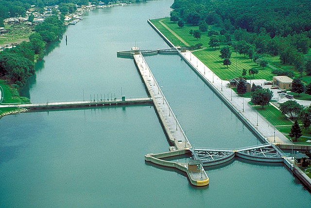
144:Aerial view of T.J. O’Brien Lock and Dam on the
94:
207:
169:
131:
199:
179:
14:
740:The following other wikis use this file:
203:Carol Arney, U.S. Army Corps of Engineers
372:View this and other nearby images on:
244:
125:
857:File written by Adobe Photoshop¨ 5.0
348:
239:
641:
13:
843:
763:Thomas J O'Brien Lock and Dam
410:
404:
321:
252:This image or file is a work of a
250:
138:
126:
72:
869:
850:
409:
709:
577:coordinates of the point of view
567:coordinates of the point of view
395:
378:
364:
243:
194:Digital Visual Library home page
93:
31:
21:
392:
139:
735:
730:T.J. O'Brien Lock and Dam
645:
391:
26:
1:
36:
715:Chicago Area Waterway System
705:
592:41°39'7.549"N, 87°34'1.841"W
417:Items portrayed in this file
254:U.S. Army Corps of Engineers
7:
840:
754:Usage on ceb.wikipedia.org
744:Usage on arz.wikipedia.org
134:T J OBrien Lock and Dam.jpg
10:
874:
824:Usage on www.wikidata.org
814:Usage on lt.wikipedia.org
804:Usage on la.wikipedia.org
789:Usage on fr.wikipedia.org
779:Usage on eo.wikipedia.org
769:Usage on de.wikipedia.org
128:
642:
16:
818:Ilinojaus vandens kelias
499:United States of America
445:United States of America
394:
100:This is a file from the
41:
699:
492:applies to jurisdiction
441:applies to jurisdiction
262:U.S. federal government
172:
148:, which is part of the
104:. Information from its
384:41.652097; -87.567178
342:Chicago, Illinois, USA
326:
264:, the image is in the
190:Image description page
107:description page there
46:Size of this preview:
325:
507:determination method
449:determination method
66:1,500 × 1,000 pixels
678:00:50, 3 April 2007
52:Other resolutions:
327:
62:1,024 × 683 pixels
861:
860:
854:JPEG file comment
798:Calumet (rivière)
793:Illinois Waterway
736:Global file usage
725:Illinois Waterway
703:
403:
389:
388:
346:
345:
331:
330:
316:
238:
237:
216:
213:Reusing this file
154:Mississippi River
150:Illinois Waterway
122:
121:
102:Wikimedia Commons
32:Global file usage
865:
851:
783:Calumet (rivero)
690:
652:
516:
511:
501:
496:
463:copyright status
433:copyright status
401:
385:
382:
368:
367:
361:
360:
349:
324:
317:
312:
247:
246:
240:
234:
231:
228:
225:
220:
219:
210:
175:
143:
135:
129:
118:
97:
96:
90:
84:
82:
69:
58:640 × 427 pixels
54:320 × 213 pixels
48:800 × 533 pixels
873:
872:
868:
867:
866:
864:
863:
862:
839:
734:
711:
704:
696:
688:
644:
643:
640:
639:
638:
637:
636:
635:
634:
633:
631:
621:
620:
619:
617:
602:
601:
600:
599:
598:
597:
596:
595:
593:
583:
582:
581:
579:
564:
563:
562:
561:
560:
559:
558:
557:
555:
545:
544:
543:
541:
526:
525:
524:
523:
522:
521:
520:
519:
518:
517:
512:
509:
503:
502:
497:
494:
485:
484:
483:
481:
469:
468:
467:
465:
430:
429:
428:
427:
426:
424:
408:
407:
406:
383:
356:
355:
352:Camera location
347:
339:
322:
275:
272:
232:
229:
226:
223:
165:
133:
124:
123:
112:
111:
110:is shown below.
86:
80:
78:
71:
70:
51:
12:
11:
5:
871:
859:
858:
855:
842:
838:
837:
836:
835:
830:
822:
821:
820:
812:
811:
810:
802:
801:
800:
795:
787:
786:
785:
777:
776:
775:
767:
766:
765:
760:
752:
751:
750:
737:
733:
732:
727:
722:
717:
707:
702:
701:
698:
694:
691:
687:1,500 × 1,000
685:
680:
675:
671:
670:
667:
664:
661:
658:
655:
647:
632:
629:
627:
626:
625:
623:
622:
618:
613:
611:
610:
609:
608:
606:
594:
591:
589:
588:
587:
585:
584:
580:
575:
573:
572:
571:
570:
568:
556:
553:
551:
550:
549:
547:
546:
542:
537:
535:
534:
533:
532:
530:
505:
504:
490:
489:
488:
487:
486:
482:
477:
475:
474:
473:
471:
470:
466:
461:
459:
458:
457:
456:
454:
450:
446:
442:
438:
434:
425:
420:
418:
415:
414:
413:
412:
400:
399:
396:
393:
387:
386:
376:
370:
353:
344:
343:
340:
337:
333:
332:
329:
328:
319:
248:
236:
235:
217:
205:
204:
201:
197:
196:
181:
177:
176:
171:
167:
166:
136:
127:
120:
119:
98:
88:
87:
45:
40:
39:
34:
29:
24:
19:
9:
6:
4:
3:
2:
870:
856:
853:
852:
849:
846:
834:
831:
829:
826:
825:
823:
819:
816:
815:
813:
809:
806:
805:
803:
799:
796:
794:
791:
790:
788:
784:
781:
780:
778:
774:
771:
770:
768:
764:
761:
759:
756:
755:
753:
749:
746:
745:
743:
742:
741:
731:
728:
726:
723:
721:
718:
716:
713:
712:
697:
692:
686:
684:
681:
679:
676:
673:
672:
668:
665:
662:
659:
656:
654:
653:
651:
628:
616:
612:
590:
578:
574:
552:
540:
536:
515:
508:
500:
493:
480:
479:public domain
476:
464:
460:
437:public domain
423:
419:
416:
397:
390:
381:
377:
375:
374:OpenStreetMap
371:
369:
359:
354:
351:
350:
341:
335:
334:
320:
318:
315:
310:
306:
302:
298:
294:
290:
286:
282:
278:
273:
271:
269:
268:
267:public domain
263:
259:
255:
249:
242:
241:
227:Public domain
224:Public domain
222:
221:
218:
214:
209:
206:
202:
198:
195:
192:
191:
188:
187:
184:
182:
178:
168:
163:
159:
158:Lake Michigan
155:
151:
147:
146:Calumet River
142:
137:
130:
116:
109:
108:
103:
99:
92:
91:
85:
76:
75:Original file
67:
63:
59:
55:
49:
44:
38:
35:
33:
30:
28:
25:
23:
20:
18:
15:
847:
844:
773:Calumet City
739:
720:Control lock
649:
646:File history
274:
265:
251:
140:
115:You can help
105:
73:
22:File history
748:نهر كالوميت
554:1 June 1992
301:slovenščina
174:1 June 1992
164:, Illinois.
132:Description
706:File usage
663:Dimensions
630:image/jpeg
615:media type
605:media type
309:українська
285:Nederlands
208:Permission
186:Image page
81:image/jpeg
27:File usage
833:Q24061751
808:Cataracta
660:Thumbnail
657:Date/Time
539:inception
529:inception
338:InfoField
297:sicilianu
141:English:
841:Metadata
828:Q2934412
689:(279 KB)
398:Captions
336:Location
311: |
307: |
303: |
299: |
295: |
291: |
287: |
283: |
281:italiano
279: |
37:Metadata
674:current
669:Comment
422:depicts
402:English
293:русский
277:English
260:of the
162:Chicago
77:
362:
305:Türkçe
200:Author
180:Source
695:DanMS
233:false
230:false
666:User
289:پښتو
258:work
170:Date
17:File
314:+/−
510::
495::
64:|
60:|
56:|
50:.
270:.
215:)
211:(
117:.
83:)
68:.
Text is available under the Creative Commons Attribution-ShareAlike License. Additional terms may apply.
