862:"}},"text\/plain":{"en":{"":"coordinates of the point of view"}}},"{\"value\":{\"latitude\":51.10445,\"longitude\":-2.3215,\"altitude\":null,\"precision\":1.0e-5,\"globe\":\"http:\\\/\\\/www.wikidata.org\\\/entity\\\/Q2\"},\"type\":\"globecoordinate\"}":{"text\/html":{"en":{"P1259":"51\u00b06'16.02"N, 2\u00b019'17.40"W"}},"text\/plain":{"en":{"P1259":"51\u00b06'16.02\"N, 2\u00b019'17.40\"W"}}},"{\"value\":{\"entity-type\":\"property\",\"numeric-id\":7787,\"id\":\"P7787\"},\"type\":\"wikibase-entityid\"}":{"text\/html":{"en":{"":"
968:"}},"text\/plain":{"en":{"":"coordinates of depicted place"}}},"{\"value\":{\"latitude\":51.10427,\"longitude\":-2.3225,\"altitude\":null,\"precision\":1.0e-5,\"globe\":\"http:\\\/\\\/www.wikidata.org\\\/entity\\\/Q2\"},\"type\":\"globecoordinate\"}":{"text\/html":{"en":{"P9149":"51\u00b06'15.37"N, 2\u00b019'21.00"W"}},"text\/plain":{"en":{"P9149":"51\u00b06'15.37\"N, 2\u00b019'21.00\"W"}}},"{\"value\":{\"entity-type\":\"property\",\"numeric-id\":7787,\"id\":\"P7787\"},\"type\":\"wikibase-entityid\"}":{"text\/html":{"en":{"":"
560:"}},"text\/plain":{"en":{"":"author name string"}}},"{\"value\":\"Chris Downer\",\"type\":\"string\"}":{"text\/html":{"en":{"P2093":"Chris Downer"}},"text\/plain":{"en":{"P2093":"Chris Downer"}}},"{\"value\":{\"entity-type\":\"property\",\"numeric-id\":3831,\"id\":\"P3831\"},\"type\":\"wikibase-entityid\"}":{"text\/html":{"en":{"":"
930:"}},"text\/plain":{"en":{"":"inception"}}},"{\"value\":{\"time\":\"+1993-01-01T00:00:00Z\",\"timezone\":0,\"before\":0,\"after\":0,\"precision\":9,\"calendarmodel\":\"http:\\\/\\\/www.wikidata.org\\\/entity\\\/Q1985727\"},\"type\":\"time\"}":{"text\/html":{"en":{"P571":"1993"}},"text\/plain":{"en":{"P571":"1993"}}}}": -->
739:
318:
268:
43:
310:
260:
964:
282:
353:
391:
396:
87:
556:"}},"text\/plain":{"en":{"P2699":"https:\/\/www.geograph.org.uk\/profile\/14700"}}},"{\"value\":{\"entity-type\":\"property\",\"numeric-id\":2093,\"id\":\"P2093\"},\"type\":\"wikibase-entityid\"}":{"text\/html":{"en":{"":"
763:"}},"text\/plain":{"en":{"P973":"https:\/\/www.geograph.org.uk\/photo\/484538"}}},"{\"value\":{\"entity-type\":\"property\",\"numeric-id\":7384,\"id\":\"P7384\"},\"type\":\"wikibase-entityid\"}":{"text\/html":{"en":{"":"
747:"}},"text\/plain":{"en":{"P7482":"file available on the internet"}}},"{\"value\":{\"entity-type\":\"property\",\"numeric-id\":137,\"id\":\"P137\"},\"type\":\"wikibase-entityid\"}":{"text\/html":{"en":{"":"
564:"}},"text\/plain":{"en":{"":"object of statement has role"}}},"{\"value\":{\"entity-type\":\"item\",\"numeric-id\":33231,\"id\":\"Q33231\"},\"type\":\"wikibase-entityid\"}":{"text\/html":{"en":{"P3831":"
755:"}},"text\/plain":{"en":{"P137":"Geograph Britain and Ireland"}}},"{\"value\":{\"entity-type\":\"property\",\"numeric-id\":973,\"id\":\"P973\"},\"type\":\"wikibase-entityid\"}":{"text\/html":{"en":{"":"
1036:"}},"text\/plain":{"en":{"":"location of creation"}}},"{\"value\":{\"entity-type\":\"item\",\"numeric-id\":4360033,\"id\":\"Q4360033\"},\"type\":\"wikibase-entityid\"}":{"text\/html":{"en":{"P1071":"
1118:
699:"}},"text\/plain":{"en":{"":"copyright license"}}},"{\"value\":{\"entity-type\":\"item\",\"numeric-id\":19068220,\"id\":\"Q19068220\"},\"type\":\"wikibase-entityid\"}":{"text\/html":{"en":{"P275":"
655:"}},"text\/plain":{"en":{"":"copyright status"}}},"{\"value\":{\"entity-type\":\"item\",\"numeric-id\":50423863,\"id\":\"Q50423863\"},\"type\":\"wikibase-entityid\"}":{"text\/html":{"en":{"P6216":"
743:"}},"text\/plain":{"en":{"":"source of file"}}},"{\"value\":{\"entity-type\":\"item\",\"numeric-id\":74228490,\"id\":\"Q74228490\"},\"type\":\"wikibase-entityid\"}":{"text\/html":{"en":{"P7482":"
972:"}},"text\/plain":{"en":{"":"heading"}}},"{\"value\":{\"amount\":\"+247\",\"unit\":\"http:\\\/\\\/www.wikidata.org\\\/entity\\\/Q28390\"},\"type\":\"quantity\"}":{"text\/html":{"en":{"P7787":"247
866:"}},"text\/plain":{"en":{"":"heading"}}},"{\"value\":{\"amount\":\"+247\",\"unit\":\"http:\\\/\\\/www.wikidata.org\\\/entity\\\/Q28390\"},\"type\":\"quantity\"}":{"text\/html":{"en":{"P7787":"247
751:"}},"text\/plain":{"en":{"":"operator"}}},"{\"value\":{\"entity-type\":\"item\",\"numeric-id\":1503119,\"id\":\"Q1503119\"},\"type\":\"wikibase-entityid\"}":{"text\/html":{"en":{"P137":"
501:"}},"text\/plain":{"en":{"":"depicts"}}},"{\"value\":{\"entity-type\":\"item\",\"numeric-id\":4968924,\"id\":\"Q4968924\"},\"type\":\"wikibase-entityid\"}":{"text\/html":{"en":{"P180":"
548:"}},"text\/plain":{"en":{"":"creator"}}},"{\"value\":{\"entity-type\":\"property\",\"numeric-id\":2699,\"id\":\"P2699\"},\"type\":\"wikibase-entityid\"}":{"text\/html":{"en":{"":"
1032:
767:"}},"text\/plain":{"en":{"":"geograph.org.uk image ID"}}},"{\"value\":\"484538\",\"type\":\"string\"}":{"text\/html":{"en":{"P7384":"
251:
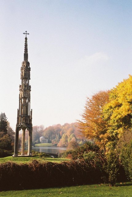
1135:== {{int:filedesc}} == {{Information |description={{en|1=Stourton: Bristol High Cross The Bristol High Cross, Stourton, with the Pantheon in Stourhead Gardens in the background. The Cross was moved from Bristol to the Stourhead garden entrance in 1765.}}
443:– You must give appropriate credit, provide a link to the license, and indicate if changes were made. You may do so in any reasonable manner, but not in any way that suggests the licensor endorses you or your use.
315:
265:
53:
47:
163:
Stourton: Bristol High Cross The
Bristol High Cross, Stourton, with the Pantheon in Stourhead Gardens in the background. The Cross was moved from Bristol to the Stourhead garden entrance in 1765.
98:
66:
768:
744:
700:
656:
1037:
752:
502:
565:
1033:
969:
965:
863:
859:
764:
740:
652:
561:
557:
549:
553:
927:
760:
756:
748:
696:
545:
498:
1169:
1128:
1154:
703:"}},"text\/plain":{"en":{"P275":"Creative Commons Attribution-ShareAlike 2.0 Generic"}}}}": -->
794:
726:
682:
325:
275:
1117:
1112:
57:
42:
1063:
814:
531:
360:
1220:
This file contains additional information, probably added from the digital camera or scanner used to create or digitize it.
450:
637:
1047:
1010:
983:
904:
877:
837:
778:
666:
630:
617:
602:
937:
822:
807:
710:
575:
515:
1159:
1040:"}},"text\/plain":{"en":{"P1071":"Stourton with Gasper"}}}}": -->
406:
1223:
If the file has been modified from its original state, some details may not fully reflect the modified file.
505:"}},"text\/plain":{"en":{"P180":"Bristol High Cross"}}}}": -->
449:– If you remix, transform, or build upon the material, you must distribute your contributions under the
367:
on the
Geograph website for the photographer's contact details. The copyright on this image is owned by
568:"}},"text\/plain":{"en":{"P3831":"photographer"}}}}": -->
125:
659:"}},"text\/plain":{"en":{"P6216":"copyrighted"}}}}": -->
130:
1145:
The following pages on the
English Knowledge use this file (pages on other projects are not listed):
976:"}},"text\/plain":{"en":{"P7787":"247 degree"}}}}": -->
870:"}},"text\/plain":{"en":{"P7787":"247 degree"}}}}": -->
106:
771:"}},"text\/plain":{"en":{"P7384":"484538"}}}}": -->
220:
609:
1187:
844:
829:
403:
204:
8:
347:
1149:
331:
281:
372:
93:
1207:
193:
183:
1057:
993:
947:
887:
788:
720:
676:
585:
525:
352:
1164:
364:
1085:
Click on a date/time to view the file as it appeared at that time.
317:
267:
153:
Stourton, Bristol High Cross - geograph.org.uk - 484538.jpg
302:
51° 06′ 15″ N, 2° 19′ 21″ W
252:
51° 06′ 16″ N, 2° 19′ 17″ W
81:
491:
Add a one-line explanation of what this file represents
1197:
1143:
1178:
1170:
Template:Did you know nominations/Bristol High Cross
1083:
105:
Commons is a freely licensed media file repository.
727:
Creative
Commons Attribution-ShareAlike 2.0 Generic
701:
Creative
Commons Attribution-ShareAlike 2.0 Generic
172:
71:(429 × 640 pixels, file size: 59 KB, MIME type:
460:https://creativecommons.org/licenses/by-sa/2.0
86:
1188:List of Grade I listed buildings in Wiltshire
1155:List of Grade I listed buildings in Wiltshire
554:https:\/\/www.geograph.org.uk\/profile\/14700
466:Creative Commons Attribution-Share Alike 2.0
384:
168:
150:
761:https:\/\/www.geograph.org.uk\/photo\/484538
189:
178:
14:
973:
867:
426:– to copy, distribute and transmit the work
1180:The following other wikis use this file:
610:https://www.geograph.org.uk/profile/14700
830:https://www.geograph.org.uk/photo/484538
324:View this and other nearby images on:
274:View this and other nearby images on:
227:
117:
371:and is licensed for reuse under the
292:
242:
1076:
407:Attribution-Share Alike 2.0 Generic
395:
390:
375:Attribution-ShareAlike 2.0 license.
13:
1218:
496:
490:
381:
358:
157:
123:
118:
64:
1244:
1225:
495:
1144:
878:coordinates of the point of view
860:coordinates of the point of view
481:
437:Under the following conditions:
402:This file is licensed under the
394:
389:
383:
351:
330:
316:
308:
280:
266:
258:
85:
31:
21:
478:
158:
1175:
1160:Scheduled monuments in Bristol
1080:
795:file available on the internet
745:file available on the internet
477:
359:This image was taken from the
26:
1:
984:coordinates of depicted place
966:coordinates of depicted place
36:
1140:
815:Geograph Britain and Ireland
753:Geograph Britain and Ireland
631:object of statement has role
562:object of statement has role
511:Items portrayed in this file
343:
307:
257:
235:Stourton: Bristol High Cross
216:Stourton: Bristol High Cross
7:
1215:
1184:Usage on dag.wikipedia.org
10:
1249:
1204:Usage on zh.wikipedia.org
1194:Usage on www.wikidata.org
999:51°6'15.37"N, 2°19'21.00"W
893:51°6'16.02"N, 2°19'17.40"W
451:same or compatible license
147:
142:
119:
1077:
233:Chris Downer /
214:Chris Downer /
16:
838:geograph.org.uk image ID
765:geograph.org.uk image ID
480:
417:
92:This is a file from the
41:
1134:
205:required by the license
171:
96:. Information from its
1113:02:47, 5 February 2011
365:this photograph's page
336:51.104270; -2.322500
286:51.104450; -2.321500
99:description page there
46:Size of this preview:
1064:Stourton with Gasper
1048:location of creation
1038:Stourton with Gasper
1034:location of creation
432:– to adapt the work
124:This is a photo of
52:Other resolutions:
1150:Bristol High Cross
618:author name string
558:author name string
532:Bristol High Cross
503:Bristol High Cross
1236:
1235:
1176:Global file usage
1138:
975:
869:
711:copyright license
697:copyright license
489:
380:
379:
363:collection. See
341:
340:
291:
290:
240:
239:
208:
140:
139:
114:
113:
94:Wikimedia Commons
32:Global file usage
1240:
1226:
1125:
1087:
1021:
1020:
1015:
915:
914:
909:
847:
842:
832:
827:
823:described at URL
817:
812:
757:described at URL
667:copyright status
653:copyright status
640:
635:
625:
622:
612:
607:
487:
473:
470:
467:
464:
461:
453:as the original.
415:
404:Creative Commons
398:
397:
393:
392:
387:
386:
373:Creative Commons
361:Geograph project
355:
348:
337:
334:
320:
319:
313:
312:
311:
305:
304:
293:
287:
284:
270:
269:
263:
262:
261:
255:
254:
243:
202:
174:
162:
154:
148:
133:
120:
110:
89:
88:
82:
76:
74:
61:
58:429 × 640 pixels
54:161 × 240 pixels
48:402 × 600 pixels
1248:
1247:
1243:
1242:
1241:
1239:
1238:
1237:
1214:
1174:
1146:
1139:
1131:
1123:
1079:
1078:
1075:
1074:
1073:
1072:
1071:
1070:
1069:
1068:
1066:
1054:
1053:
1052:
1050:
1031:
1030:
1029:
1028:
1027:
1026:
1025:
1024:
1023:
1022:
1018:
1016:
1013:
1004:
1003:
1002:
1000:
990:
989:
988:
986:
963:
962:
961:
960:
959:
958:
957:
956:
954:
944:
943:
942:
940:
925:
924:
923:
922:
921:
920:
919:
918:
917:
916:
912:
910:
907:
898:
897:
896:
894:
884:
883:
882:
880:
857:
856:
855:
854:
853:
852:
851:
850:
849:
848:
843:
840:
834:
833:
828:
825:
819:
818:
813:
810:
801:
800:
799:
797:
785:
784:
783:
781:
738:
737:
736:
735:
734:
733:
732:
731:
729:
717:
716:
715:
713:
694:
693:
692:
691:
690:
689:
688:
687:
685:
673:
672:
671:
669:
650:
649:
648:
647:
646:
645:
644:
643:
642:
641:
636:
633:
627:
626:
623:
620:
614:
613:
608:
605:
596:
595:
594:
592:
582:
581:
580:
578:
543:
542:
541:
540:
539:
538:
537:
536:
534:
522:
521:
520:
518:
494:
493:
492:
475:
474:
471:
468:
465:
462:
459:
458:
416:
413:
410:
399:
376:
346:
335:
309:
300:
299:
296:Object location
285:
259:
250:
249:
246:Camera location
241:
230:
223:
211:
184:geograph.org.uk
164:
152:
145:
135:
129:
126:listed building
116:
115:
104:
103:
102:is shown below.
78:
72:
70:
63:
62:
51:
12:
11:
5:
1246:
1234:
1233:
1230:
1217:
1213:
1212:
1211:
1210:
1202:
1201:
1200:
1192:
1191:
1190:
1177:
1173:
1172:
1167:
1162:
1157:
1152:
1142:
1137:
1136:
1133:
1129:
1126:
1120:
1115:
1110:
1106:
1105:
1102:
1099:
1096:
1093:
1090:
1082:
1067:
1062:
1060:
1059:
1058:
1056:
1055:
1051:
1046:
1044:
1043:
1042:
1041:
1039:
1035:
1009:
1008:
1007:
1006:
1005:
1001:
998:
996:
995:
994:
992:
991:
987:
982:
980:
979:
978:
977:
971:
967:
955:
952:
950:
949:
948:
946:
945:
941:
936:
934:
933:
932:
931:
929:
903:
902:
901:
900:
899:
895:
892:
890:
889:
888:
886:
885:
881:
876:
874:
873:
872:
871:
865:
861:
836:
835:
821:
820:
806:
805:
804:
803:
802:
798:
793:
791:
790:
789:
787:
786:
782:
779:source of file
777:
775:
774:
773:
772:
770:
766:
762:
758:
754:
750:
746:
742:
741:source of file
730:
725:
723:
722:
721:
719:
718:
714:
709:
707:
706:
705:
704:
702:
698:
686:
681:
679:
678:
677:
675:
674:
670:
665:
663:
662:
661:
660:
658:
654:
629:
628:
616:
615:
601:
600:
599:
598:
597:
593:
590:
588:
587:
586:
584:
583:
579:
574:
572:
571:
570:
569:
567:
563:
559:
555:
551:
547:
535:
530:
528:
527:
526:
524:
523:
519:
514:
512:
509:
508:
507:
506:
504:
500:
486:
485:
482:
479:
457:
456:
455:
454:
444:
435:
434:
433:
427:
420:You are free:
411:
401:
400:
382:
378:
377:
356:
345:
342:
339:
338:
328:
322:
297:
289:
288:
278:
272:
247:
238:
237:
231:
228:
225:
224:
219:
212:
209:
197:
196:
191:
187:
186:
180:
176:
175:
170:
166:
165:
155:
146:
144:
141:
138:
137:
112:
111:
90:
80:
79:
45:
40:
39:
34:
29:
24:
19:
9:
6:
4:
3:
2:
1245:
1231:
1228:
1227:
1224:
1221:
1209:
1206:
1205:
1203:
1199:
1196:
1195:
1193:
1189:
1186:
1185:
1183:
1182:
1181:
1171:
1168:
1166:
1163:
1161:
1158:
1156:
1153:
1151:
1148:
1147:
1132:
1127:
1121:
1119:
1116:
1114:
1111:
1108:
1107:
1103:
1100:
1097:
1094:
1091:
1089:
1088:
1086:
1065:
1061:
1049:
1045:
1012:
997:
985:
981:
951:
939:
935:
906:
891:
879:
875:
846:
839:
831:
824:
816:
809:
796:
792:
780:
776:
728:
724:
712:
708:
684:
680:
668:
664:
639:
632:
619:
611:
604:
589:
577:
573:
533:
529:
517:
513:
510:
483:
476:
463:CC BY-SA 2.0
452:
448:
445:
442:
439:
438:
436:
431:
428:
425:
422:
421:
419:
418:
412:Attribution:
408:
405:
388:
374:
370:
366:
362:
357:
354:
350:
349:
333:
329:
327:
326:OpenStreetMap
323:
321:
303:
298:
295:
294:
283:
279:
277:
276:OpenStreetMap
273:
271:
253:
248:
245:
244:
236:
232:
226:
222:
218: /
217:
213:
206:
201:
199:
198:
195:
192:
188:
185:
181:
177:
167:
161:
156:
149:
136:
132:
127:
122:
121:
108:
101:
100:
95:
91:
84:
83:
77:
68:
67:Original file
59:
55:
49:
44:
38:
35:
33:
30:
28:
25:
23:
20:
18:
15:
1222:
1219:
1179:
1084:
1081:File history
638:photographer
624:Chris Downer
566:photographer
446:
440:
429:
423:
414:Chris Downer
369:Chris Downer
368:
306:
256:
234:
221:CC BY-SA 2.0
215:
194:Chris Downer
159:
107:You can help
97:
65:
22:File history
1130:GeographBot
683:copyrighted
657:copyrighted
447:share alike
441:attribution
200:Attribution
151:Description
1229:_error
1141:File usage
1122:429 × 640
1098:Dimensions
591:some value
73:image/jpeg
27:File usage
1165:Stourhead
1095:Thumbnail
1092:Date/Time
938:inception
928:inception
344:Licensing
229:InfoField
210:InfoField
160:English:
1216:Metadata
1198:Q4968924
808:operator
749:operator
484:Captions
430:to remix
424:to share
409:license.
37:Metadata
1124:(59 KB)
1109:current
1104:Comment
1011:heading
970:heading
905:heading
864:heading
576:creator
546:creator
516:depicts
499:depicts
488:English
143:Summary
131:1318471
128:number
69:
1019:degree
974:degree
913:degree
868:degree
845:484538
769:484538
314:
264:
190:Author
179:Source
182:From
1208:斯托海德
1101:User
1017:247
953:1993
911:247
472:true
469:true
173:1993
169:Date
17:File
603:URL
550:URL
1014::
908::
841::
826::
811::
634::
621::
606::
56:|
50:.
1232:0
207:)
203:(
134:.
109:.
75:)
60:.
Text is available under the Creative Commons Attribution-ShareAlike License. Additional terms may apply.
_heading:247.00&language=en)
_heading:247.00&language=en)
