910:"}},"text\/plain":{"en":{"":"coordinates of the point of view"}}},"{\"value\":{\"latitude\":50.834395,\"longitude\":-0.389026,\"altitude\":null,\"precision\":1.0e-6,\"globe\":\"http:\\\/\\\/www.wikidata.org\\\/entity\\\/Q2\"},\"type\":\"globecoordinate\"}":{"text\/html":{"en":{"P1259":"50\u00b050'3.822"N, 0\u00b023'20.494"W"}},"text\/plain":{"en":{"P1259":"50\u00b050'3.822\"N, 0\u00b023'20.494\"W"}}},"{\"value\":{\"entity-type\":\"property\",\"numeric-id\":7787,\"id\":\"P7787\"},\"type\":\"wikibase-entityid\"}":{"text\/html":{"en":{"":"
978:"}},"text\/plain":{"en":{"":"coordinates of depicted place"}}},"{\"value\":{\"latitude\":50.83462,\"longitude\":-0.3892,\"altitude\":null,\"precision\":1.0e-5,\"globe\":\"http:\\\/\\\/www.wikidata.org\\\/entity\\\/Q2\"},\"type\":\"globecoordinate\"}":{"text\/html":{"en":{"P9149":"50\u00b050'4.63"N, 0\u00b023'21.12"W"}},"text\/plain":{"en":{"P9149":"50\u00b050'4.63\"N, 0\u00b023'21.12\"W"}}},"{\"value\":{\"entity-type\":\"property\",\"numeric-id\":7787,\"id\":\"P7787\"},\"type\":\"wikibase-entityid\"}":{"text\/html":{"en":{"":"
562:"}},"text\/plain":{"en":{"":"author name string"}}},"{\"value\":\"Peter Holmes\",\"type\":\"string\"}":{"text\/html":{"en":{"P2093":"Peter Holmes"}},"text\/plain":{"en":{"P2093":"Peter Holmes"}}},"{\"value\":{\"entity-type\":\"property\",\"numeric-id\":2699,\"id\":\"P2699\"},\"type\":\"wikibase-entityid\"}":{"text\/html":{"en":{"":"
872:"}},"text\/plain":{"en":{"":"inception"}}},"{\"value\":{\"time\":\"+2008-01-09T00:00:00Z\",\"timezone\":0,\"before\":0,\"after\":0,\"precision\":11,\"calendarmodel\":\"http:\\\/\\\/www.wikidata.org\\\/entity\\\/Q1985727\"},\"type\":\"time\"}":{"text\/html":{"en":{"P571":"9 January 2008"}},"text\/plain":{"en":{"P571":"9 January 2008"}}}}": -->
749:
554:
278:
974:
270:
342:
292:
363:
401:
406:
72:
570:"}},"text\/plain":{"en":{"P2699":"https:\/\/www.geograph.org.uk\/profile\/17959"}}},"{\"value\":{\"entity-type\":\"property\",\"numeric-id\":3831,\"id\":\"P3831\"},\"type\":\"wikibase-entityid\"}":{"text\/html":{"en":{"":"
1166:
757:"}},"text\/plain":{"en":{"P7482":"file available on the internet"}}},"{\"value\":{\"entity-type\":\"property\",\"numeric-id\":7384,\"id\":\"P7384\"},\"type\":\"wikibase-entityid\"}":{"text\/html":{"en":{"":"
574:"}},"text\/plain":{"en":{"":"object of statement has role"}}},"{\"value\":{\"entity-type\":\"item\",\"numeric-id\":33231,\"id\":\"Q33231\"},\"type\":\"wikibase-entityid\"}":{"text\/html":{"en":{"P3831":"
773:"}},"text\/plain":{"en":{"P137":"Geograph Britain and Ireland"}}},"{\"value\":{\"entity-type\":\"property\",\"numeric-id\":973,\"id\":\"P973\"},\"type\":\"wikibase-entityid\"}":{"text\/html":{"en":{"":"
1046:"}},"text\/plain":{"en":{"":"location of creation"}}},"{\"value\":{\"entity-type\":\"item\",\"numeric-id\":21886170,\"id\":\"Q21886170\"},\"type\":\"wikibase-entityid\"}":{"text\/html":{"en":{"P1071":"
1090:"}},"text\/plain":{"en":{"":"media type"}}},"{\"value\":\"image\\\/jpeg\",\"type\":\"string\"}":{"text\/html":{"en":{"P1163":"image\/jpeg"}},"text\/plain":{"en":{"P1163":"image\/jpeg"}}}}": -->
709:"}},"text\/plain":{"en":{"":"copyright license"}}},"{\"value\":{\"entity-type\":\"item\",\"numeric-id\":19068220,\"id\":\"Q19068220\"},\"type\":\"wikibase-entityid\"}":{"text\/html":{"en":{"P275":"
665:"}},"text\/plain":{"en":{"":"copyright status"}}},"{\"value\":{\"entity-type\":\"item\",\"numeric-id\":50423863,\"id\":\"Q50423863\"},\"type\":\"wikibase-entityid\"}":{"text\/html":{"en":{"P6216":"
753:"}},"text\/plain":{"en":{"":"source of file"}}},"{\"value\":{\"entity-type\":\"item\",\"numeric-id\":74228490,\"id\":\"Q74228490\"},\"type\":\"wikibase-entityid\"}":{"text\/html":{"en":{"P7482":"
511:"}},"text\/plain":{"en":{"":"depicts"}}},"{\"value\":{\"entity-type\":\"item\",\"numeric-id\":26542358,\"id\":\"Q26542358\"},\"type\":\"wikibase-entityid\"}":{"text\/html":{"en":{"P180":"
982:"}},"text\/plain":{"en":{"":"heading"}}},"{\"value\":{\"amount\":\"+315\",\"unit\":\"http:\\\/\\\/www.wikidata.org\\\/entity\\\/Q28390\"},\"type\":\"quantity\"}":{"text\/html":{"en":{"P7787":"315
914:"}},"text\/plain":{"en":{"":"heading"}}},"{\"value\":{\"amount\":\"+315\",\"unit\":\"http:\\\/\\\/www.wikidata.org\\\/entity\\\/Q28390\"},\"type\":\"quantity\"}":{"text\/html":{"en":{"P7787":"315
769:"}},"text\/plain":{"en":{"":"operator"}}},"{\"value\":{\"entity-type\":\"item\",\"numeric-id\":1503119,\"id\":\"Q1503119\"},\"type\":\"wikibase-entityid\"}":{"text\/html":{"en":{"P137":"
765:"}},"text\/plain":{"en":{"P7384":"656643"}}},"{\"value\":{\"entity-type\":\"property\",\"numeric-id\":137,\"id\":\"P137\"},\"type\":\"wikibase-entityid\"}":{"text\/html":{"en":{"":"
558:"}},"text\/plain":{"en":{"":"creator"}}},"{\"value\":{\"entity-type\":\"property\",\"numeric-id\":2093,\"id\":\"P2093\"},\"type\":\"wikibase-entityid\"}":{"text\/html":{"en":{"":"
1086:
777:"}},"text\/plain":{"en":{"":"described at URL"}}},"{\"value\":\"https:\\\/\\\/www.geograph.org.uk\\\/photo\\\/656643\",\"type\":\"string\"}":{"text\/html":{"en":{"P973":"
311:
566:"}},"text\/plain":{"en":{"":"URL"}}},"{\"value\":\"https:\\\/\\\/www.geograph.org.uk\\\/profile\\\/17959\",\"type\":\"string\"}":{"text\/html":{"en":{"P2699":"
761:"}},"text\/plain":{"en":{"":"geograph.org.uk image ID"}}},"{\"value\":\"656643\",\"type\":\"string\"}":{"text\/html":{"en":{"P7384":"
261:
453:– You must give appropriate credit, provide a link to the license, and indicate if changes were made. You may do so in any reasonable manner, but not in any way that suggests the licensor endorses you or your use.
51:
275:
83:
325:
1176:
1047:
762:
754:
710:
666:
512:
770:
575:
1087:
1043:
979:
975:
911:
907:
758:
750:
662:
571:
563:
559:
567:
869:
778:
774:
766:
706:
555:
508:
148:
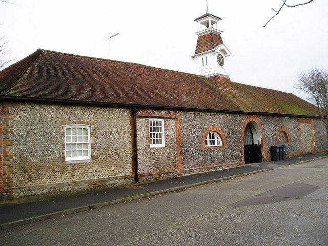
Stable Mews, Hall Avenue, Offington, Worthing, West Sussex. Built in the 18th century as the stables of
Offington Hall. In the 20th century it was a riding school.
713:"}},"text\/plain":{"en":{"P275":"Creative Commons Attribution-ShareAlike 2.0 Generic"}}}}": -->
1165:
1160:
198:
42:
781:"}},"text\/plain":{"en":{"P973":"https:\/\/www.geograph.org.uk\/photo\/656643"}}}}": -->
1073:
804:
736:
692:
541:
335:
285:
839:
370:
1247:
This file contains additional information, probably added from the digital camera or scanner used to create or digitize it.
460:
647:
1097:
1057:
1020:
993:
952:
925:
817:
788:
676:
640:
625:
612:
879:
847:
832:
720:
585:
525:
515:"}},"text\/plain":{"en":{"P180":"Offington Hall Riding School"}}}}": -->
416:
1201:
1250:
If the file has been modified from its original state, some details may not fully reflect the modified file.
1183:== Summary == {{Information |Description=Stable Mews, Hall Avenue, Worthing |Source=From ; transferd by
459:– If you remix, transform, or build upon the material, you must distribute your contributions under the
377:
on the
Geograph website for the photographer's contact details. The copyright on this image is owned by
578:"}},"text\/plain":{"en":{"P3831":"photographer"}}}}": -->
110:
669:"}},"text\/plain":{"en":{"P6216":"copyrighted"}}}}": -->
115:
1197:
The following pages on the
English Knowledge use this file (pages on other projects are not listed):
986:"}},"text\/plain":{"en":{"P7787":"315 degree"}}}}": -->
918:"}},"text\/plain":{"en":{"P7787":"315 degree"}}}}": -->
1050:"}},"text\/plain":{"en":{"P1071":"Worthing"}}}}": -->
91:
230:
632:
854:
824:
413:
214:
8:
357:
341:
291:
382:
78:
172:
1184:
187:
168:
1187:
using [http://toolserver.org/~magnus/geograph_org2commons.php geograph_org
1107:
1067:
1003:
935:
889:
798:
730:
686:
595:
535:
362:
1206:
374:
1133:
Click on a date/time to view the file as it appeared at that time.
138:
Stable Mews, Hall Avenue, Worthing - geograph.org.uk - 656643.jpg
52:
Stable_Mews,_Hall_Avenue,_Worthing_-_geograph.org.uk_-_656643.jpg
327:
277:
262:
50° 50′ 03.82″ N, 0° 23′ 20.49″ W
176:
312:
50° 50′ 05″ N, 0° 23′ 21″ W
157:
66:
501:
Add a one-line explanation of what this file represents
1224:
1234:
1195:
1215:
1131:
205:
Creative
Commons Attribution Share-alike license 2.0
90:
Commons is a freely licensed media file repository.
737:
Creative
Commons Attribution-ShareAlike 2.0 Generic
711:
Creative
Commons Attribution-ShareAlike 2.0 Generic
56:(640 × 480 pixels, file size: 88 KB, MIME type:
470:https://creativecommons.org/licenses/by-sa/2.0
71:
568:https:\/\/www.geograph.org.uk\/profile\/17959
476:Creative Commons Attribution-Share Alike 2.0
394:
193:
153:
135:
779:https:\/\/www.geograph.org.uk\/photo\/656643
183:
163:
14:
983:
915:
436:– to copy, distribute and transmit the work
1217:The following other wikis use this file:
633:https://www.geograph.org.uk/profile/17959
855:https://www.geograph.org.uk/photo/656643
334:View this and other nearby images on:
284:View this and other nearby images on:
237:
102:
381:and is licensed for reuse under the
302:
252:
1124:
417:Attribution-Share Alike 2.0 Generic
405:
400:
385:Attribution-ShareAlike 2.0 license.
13:
1245:
506:
500:
391:
368:
245:Stable Mews, Hall Avenue, Worthing
226:Stable Mews, Hall Avenue, Worthing
142:
108:
103:
49:
1271:
1252:
505:
1196:
926:coordinates of the point of view
908:coordinates of the point of view
491:
447:Under the following conditions:
412:This file is licensed under the
404:
399:
393:
361:
340:
326:
318:
290:
276:
268:
70:
31:
21:
1178:File Upload Bot (Magnus Manske)
488:
143:
46:No higher resolution available.
1212:
1128:
805:file available on the internet
755:file available on the internet
487:
369:This image was taken from the
26:
1:
1202:Edward Alford (Colchester MP)
994:coordinates of depicted place
976:coordinates of depicted place
36:
1192:
941:50°50'3.822"N, 0°23'20.494"W
840:Geograph Britain and Ireland
771:Geograph Britain and Ireland
641:object of statement has role
572:object of statement has role
542:Offington Hall Riding School
521:Items portrayed in this file
513:Offington Hall Riding School
353:
317:
267:
7:
1242:
10:
1276:
1231:Usage on www.wikidata.org
1221:Usage on pl.wikipedia.org
1009:50°50'4.63"N, 0°23'21.12"W
461:same or compatible license
132:
127:
104:
1125:
243:Peter Holmes /
224:Peter Holmes /
16:
818:geograph.org.uk image ID
759:geograph.org.uk image ID
490:
427:
77:This is a file from the
41:
1182:
1161:17:35, 24 December 2009
215:required by the license
156:
81:. Information from its
375:this photograph's page
346:50.834620; -0.389200
296:50.834395; -0.389026
84:description page there
1058:location of creation
1044:location of creation
177:geograph_org2commons
442:– to adapt the work
109:This is a photo of
613:author name string
560:author name string
1263:
1262:
1213:Global file usage
1190:
985:
917:
721:copyright license
707:copyright license
499:
390:
389:
373:collection. See
351:
350:
301:
300:
250:
249:
218:
202:
199:Reusing this file
171:; transferred by
125:
124:
99:
98:
79:Wikimedia Commons
32:Global file usage
1267:
1253:
1173:
1135:
1031:
1030:
1025:
963:
962:
957:
857:
852:
848:described at URL
842:
837:
827:
822:
775:described at URL
677:copyright status
663:copyright status
650:
645:
635:
630:
620:
617:
497:
483:
480:
477:
474:
471:
463:as the original.
425:
414:Creative Commons
408:
407:
403:
402:
397:
396:
383:Creative Commons
371:Geograph project
365:
358:
347:
344:
330:
329:
323:
322:
321:
315:
314:
303:
297:
294:
280:
279:
273:
272:
271:
265:
264:
253:
212:
196:
159:
147:
139:
133:
118:
105:
95:
74:
73:
67:
61:
59:
1275:
1274:
1270:
1269:
1268:
1266:
1265:
1264:
1241:
1211:
1198:
1191:
1185:User:Multichill
1179:
1171:
1127:
1126:
1123:
1122:
1121:
1120:
1119:
1118:
1117:
1116:
1114:
1104:
1103:
1102:
1100:
1085:
1084:
1083:
1082:
1081:
1080:
1079:
1078:
1076:
1064:
1063:
1062:
1060:
1041:
1040:
1039:
1038:
1037:
1036:
1035:
1034:
1033:
1032:
1028:
1026:
1023:
1014:
1013:
1012:
1010:
1000:
999:
998:
996:
973:
972:
971:
970:
969:
968:
967:
966:
965:
964:
960:
958:
955:
946:
945:
944:
942:
932:
931:
930:
928:
905:
904:
903:
902:
901:
900:
899:
898:
896:
886:
885:
884:
882:
867:
866:
865:
864:
863:
862:
861:
860:
859:
858:
853:
850:
844:
843:
838:
835:
829:
828:
823:
820:
811:
810:
809:
807:
795:
794:
793:
791:
748:
747:
746:
745:
744:
743:
742:
741:
739:
727:
726:
725:
723:
704:
703:
702:
701:
700:
699:
698:
697:
695:
683:
682:
681:
679:
660:
659:
658:
657:
656:
655:
654:
653:
652:
651:
646:
643:
637:
636:
631:
628:
622:
621:
618:
615:
606:
605:
604:
602:
592:
591:
590:
588:
553:
552:
551:
550:
549:
548:
547:
546:
544:
532:
531:
530:
528:
504:
503:
502:
485:
484:
481:
478:
475:
472:
469:
468:
426:
423:
420:
409:
386:
356:
345:
319:
310:
309:
306:Object location
295:
269:
260:
259:
256:Camera location
251:
240:
233:
221:
173:User:Multichill
169:geograph.org.uk
149:
137:
130:
120:
114:
111:listed building
101:
100:
89:
88:
87:is shown below.
63:
57:
55:
48:
47:
12:
11:
5:
1273:
1261:
1260:
1257:
1244:
1240:
1239:
1238:
1237:
1229:
1228:
1227:
1214:
1210:
1209:
1204:
1194:
1189:
1188:
1181:
1177:
1174:
1168:
1163:
1158:
1154:
1153:
1150:
1147:
1144:
1141:
1138:
1130:
1115:
1112:
1110:
1109:
1108:
1106:
1105:
1101:
1096:
1094:
1093:
1092:
1091:
1089:
1077:
1072:
1070:
1069:
1068:
1066:
1065:
1061:
1056:
1054:
1053:
1052:
1051:
1049:
1045:
1019:
1018:
1017:
1016:
1015:
1011:
1008:
1006:
1005:
1004:
1002:
1001:
997:
992:
990:
989:
988:
987:
981:
977:
951:
950:
949:
948:
947:
943:
940:
938:
937:
936:
934:
933:
929:
924:
922:
921:
920:
919:
913:
909:
897:
895:9 January 2008
894:
892:
891:
890:
888:
887:
883:
878:
876:
875:
874:
873:
871:
846:
845:
831:
830:
816:
815:
814:
813:
812:
808:
803:
801:
800:
799:
797:
796:
792:
789:source of file
787:
785:
784:
783:
782:
780:
776:
772:
768:
764:
760:
756:
752:
751:source of file
740:
735:
733:
732:
731:
729:
728:
724:
719:
717:
716:
715:
714:
712:
708:
696:
691:
689:
688:
687:
685:
684:
680:
675:
673:
672:
671:
670:
668:
664:
639:
638:
624:
623:
611:
610:
609:
608:
607:
603:
600:
598:
597:
596:
594:
593:
589:
584:
582:
581:
580:
579:
577:
573:
569:
565:
561:
557:
545:
540:
538:
537:
536:
534:
533:
529:
524:
522:
519:
518:
517:
516:
514:
510:
496:
495:
492:
489:
467:
466:
465:
464:
454:
445:
444:
443:
437:
430:You are free:
421:
411:
410:
392:
388:
387:
366:
355:
352:
349:
348:
338:
332:
307:
299:
298:
288:
282:
257:
248:
247:
241:
238:
235:
234:
229:
222:
219:
207:
206:
203:
191:
190:
185:
181:
180:
165:
161:
160:
158:9 January 2008
155:
151:
150:
140:
131:
129:
126:
123:
122:
97:
96:
75:
65:
64:
45:
40:
39:
34:
29:
24:
19:
9:
6:
4:
3:
2:
1272:
1258:
1255:
1254:
1251:
1248:
1236:
1233:
1232:
1230:
1226:
1223:
1222:
1220:
1219:
1218:
1208:
1205:
1203:
1200:
1199:
1186:
1180:
1175:
1169:
1167:
1164:
1162:
1159:
1156:
1155:
1151:
1148:
1145:
1142:
1139:
1137:
1136:
1134:
1111:
1099:
1095:
1075:
1071:
1059:
1055:
1022:
1007:
995:
991:
954:
939:
927:
923:
893:
881:
877:
856:
849:
841:
834:
826:
819:
806:
802:
790:
786:
738:
734:
722:
718:
694:
690:
678:
674:
649:
642:
634:
627:
614:
599:
587:
583:
543:
539:
527:
523:
520:
493:
486:
473:CC BY-SA 2.0
462:
458:
455:
452:
449:
448:
446:
441:
438:
435:
432:
431:
429:
428:
422:Attribution:
418:
415:
398:
384:
380:
376:
372:
367:
364:
360:
359:
343:
339:
337:
336:OpenStreetMap
333:
331:
313:
308:
305:
304:
293:
289:
287:
286:OpenStreetMap
283:
281:
263:
258:
255:
254:
246:
242:
236:
232:
228: /
227:
223:
216:
211:
209:
208:
204:
200:
195:
192:
189:
186:
182:
178:
174:
170:
166:
162:
152:
146:
141:
134:
121:
117:
112:
107:
106:
93:
86:
85:
80:
76:
69:
68:
62:
53:
44:
38:
35:
33:
30:
28:
25:
23:
20:
18:
15:
1249:
1246:
1216:
1132:
1129:File history
648:photographer
619:Peter Holmes
576:photographer
456:
450:
439:
433:
424:Peter Holmes
379:Peter Holmes
378:
316:
266:
244:
231:CC BY-SA 2.0
225:
188:Peter Holmes
144:
92:You can help
82:
50:
22:File history
693:copyrighted
667:copyrighted
457:share alike
451:attribution
210:Attribution
136:Description
1256:_error
1193:File usage
1170:640 × 480
1146:Dimensions
1113:image/jpeg
1098:media type
1088:media type
601:some value
194:Permission
58:image/jpeg
27:File usage
1225:Offington
1207:Offington
1143:Thumbnail
1140:Date/Time
880:inception
870:inception
354:Licensing
239:InfoField
220:InfoField
145:English:
1243:Metadata
1235:Q7079627
1074:Worthing
1048:Worthing
833:operator
767:operator
494:Captions
440:to remix
434:to share
419:license.
37:Metadata
1172:(88 KB)
1157:current
1152:Comment
1021:heading
980:heading
953:heading
912:heading
586:creator
556:creator
526:depicts
509:depicts
498:English
128:Summary
116:1250302
113:number
54:
1029:degree
984:degree
961:degree
916:degree
825:656643
763:656643
324:
274:
184:Author
175:using
164:Source
167:From
1149:User
1027:315
959:315
482:true
479:true
154:Date
17:File
626:URL
564:URL
1024::
956::
851::
836::
821::
644::
629::
616::
1259:0
217:)
213:(
201:)
197:(
179:.
119:.
94:.
60:)
Text is available under the Creative Commons Attribution-ShareAlike License. Additional terms may apply.
_region:GB-ENG_heading:315.00&language=en)
