894:"}},"text\/plain":{"en":{"":"coordinates of the point of view"}}},"{\"value\":{\"latitude\":51.69474,\"longitude\":-3.2075,\"altitude\":null,\"precision\":1.0e-5,\"globe\":\"http:\\\/\\\/www.wikidata.org\\\/entity\\\/Q2\"},\"type\":\"globecoordinate\"}":{"text\/html":{"en":{"P1259":"51\u00b041'41.06"N, 3\u00b012'27.00"W"}},"text\/plain":{"en":{"P1259":"51\u00b041'41.06\"N, 3\u00b012'27.00\"W"}}},"{\"value\":{\"entity-type\":\"property\",\"numeric-id\":7787,\"id\":\"P7787\"},\"type\":\"wikibase-entityid\"}":{"text\/html":{"en":{"":"
1006:"}},"text\/plain":{"en":{"":"coordinates of depicted place"}}},"{\"value\":{\"latitude\":51.69537,\"longitude\":-3.2077,\"altitude\":null,\"precision\":1.0e-5,\"globe\":\"http:\\\/\\\/www.wikidata.org\\\/entity\\\/Q2\"},\"type\":\"globecoordinate\"}":{"text\/html":{"en":{"P9149":"51\u00b041'43.33"N, 3\u00b012'27.72"W"}},"text\/plain":{"en":{"P9149":"51\u00b041'43.33\"N, 3\u00b012'27.72\"W"}}},"{\"value\":{\"entity-type\":\"property\",\"numeric-id\":7787,\"id\":\"P7787\"},\"type\":\"wikibase-entityid\"}":{"text\/html":{"en":{"":"
546:"}},"text\/plain":{"en":{"":"author name string"}}},"{\"value\":\"Robin Drayton\",\"type\":\"string\"}":{"text\/html":{"en":{"P2093":"Robin Drayton"}},"text\/plain":{"en":{"P2093":"Robin Drayton"}}},"{\"value\":{\"entity-type\":\"property\",\"numeric-id\":2699,\"id\":\"P2699\"},\"type\":\"wikibase-entityid\"}":{"text\/html":{"en":{"":"
856:"}},"text\/plain":{"en":{"":"inception"}}},"{\"value\":{\"time\":\"+2007-09-27T00:00:00Z\",\"timezone\":0,\"before\":0,\"after\":0,\"precision\":11,\"calendarmodel\":\"http:\\\/\\\/www.wikidata.org\\\/entity\\\/Q1985727\"},\"type\":\"time\"}":{"text\/html":{"en":{"P571":"27 September 2007"}},"text\/plain":{"en":{"P571":"27 September 2007"}}}}": -->
733:
312:
262:
304:
254:
1002:
276:
347:
385:
390:
72:
110:
1202:"}},"text\/plain":{"en":{"":"ISO speed"}}},"{\"value\":{\"amount\":\"+100\",\"unit\":\"1\"},\"type\":\"quantity\"}":{"text\/html":{"en":{"P6789":"100"}},"text\/plain":{"en":{"P6789":"100"}}}}": -->
1119:"}},"text\/plain":{"en":{"":"f-number"}}},"{\"value\":{\"amount\":\"+2.8\",\"unit\":\"1\"},\"type\":\"quantity\"}":{"text\/html":{"en":{"P6790":"2.8"}},"text\/plain":{"en":{"P6790":"2.8"}}}}": -->
554:"}},"text\/plain":{"en":{"P2699":"https:\/\/www.geograph.org.uk\/profile\/15303"}}},"{\"value\":{\"entity-type\":\"property\",\"numeric-id\":3831,\"id\":\"P3831\"},\"type\":\"wikibase-entityid\"}":{"text\/html":{"en":{"":"
741:"}},"text\/plain":{"en":{"P7482":"file available on the internet"}}},"{\"value\":{\"entity-type\":\"property\",\"numeric-id\":7384,\"id\":\"P7384\"},\"type\":\"wikibase-entityid\"}":{"text\/html":{"en":{"":"
1360:
558:"}},"text\/plain":{"en":{"":"object of statement has role"}}},"{\"value\":{\"entity-type\":\"item\",\"numeric-id\":33231,\"id\":\"Q33231\"},\"type\":\"wikibase-entityid\"}":{"text\/html":{"en":{"P3831":"
757:"}},"text\/plain":{"en":{"P137":"Geograph Britain and Ireland"}}},"{\"value\":{\"entity-type\":\"property\",\"numeric-id\":973,\"id\":\"P973\"},\"type\":\"wikibase-entityid\"}":{"text\/html":{"en":{"":"
1240:"}},"text\/plain":{"en":{"":"media type"}}},"{\"value\":\"image\\\/jpeg\",\"type\":\"string\"}":{"text\/html":{"en":{"P1163":"image\/jpeg"}},"text\/plain":{"en":{"P1163":"image\/jpeg"}}}}": -->
1074:"}},"text\/plain":{"en":{"":"exposure time"}}},"{\"value\":{\"amount\":\"+0.0025\",\"unit\":\"http:\\\/\\\/www.wikidata.org\\\/entity\\\/Q11574\"},\"type\":\"quantity\"}":{"text\/html":{"en":{"P6757":"0.0025
962:"}},"text\/plain":{"en":{"":"location of creation"}}},"{\"value\":{\"entity-type\":\"item\",\"numeric-id\":748065,\"id\":\"Q748065\"},\"type\":\"wikibase-entityid\"}":{"text\/html":{"en":{"P1071":"
693:"}},"text\/plain":{"en":{"":"copyright license"}}},"{\"value\":{\"entity-type\":\"item\",\"numeric-id\":19068220,\"id\":\"Q19068220\"},\"type\":\"wikibase-entityid\"}":{"text\/html":{"en":{"P275":"
649:"}},"text\/plain":{"en":{"":"copyright status"}}},"{\"value\":{\"entity-type\":\"item\",\"numeric-id\":50423863,\"id\":\"Q50423863\"},\"type\":\"wikibase-entityid\"}":{"text\/html":{"en":{"P6216":"
737:"}},"text\/plain":{"en":{"":"source of file"}}},"{\"value\":{\"entity-type\":\"item\",\"numeric-id\":74228490,\"id\":\"Q74228490\"},\"type\":\"wikibase-entityid\"}":{"text\/html":{"en":{"P7482":"
1157:"}},"text\/plain":{"en":{"":"focal length"}}},"{\"value\":{\"amount\":\"+6.1\",\"unit\":\"http:\\\/\\\/www.wikidata.org\\\/entity\\\/Q174789\"},\"type\":\"quantity\"}":{"text\/html":{"en":{"P2151":"6.1
495:"}},"text\/plain":{"en":{"":"depicts"}}},"{\"value\":{\"entity-type\":\"item\",\"numeric-id\":17739796,\"id\":\"Q17739796\"},\"type\":\"wikibase-entityid\"}":{"text\/html":{"en":{"P180":"
1278:"}},"text\/plain":{"en":{"":"instance of"}}},"{\"value\":{\"entity-type\":\"item\",\"numeric-id\":125191,\"id\":\"Q125191\"},\"type\":\"wikibase-entityid\"}":{"text\/html":{"en":{"P31":"
1010:"}},"text\/plain":{"en":{"":"heading"}}},"{\"value\":{\"amount\":\"+337\",\"unit\":\"http:\\\/\\\/www.wikidata.org\\\/entity\\\/Q28390\"},\"type\":\"quantity\"}":{"text\/html":{"en":{"P7787":"337
898:"}},"text\/plain":{"en":{"":"heading"}}},"{\"value\":{\"amount\":\"+337\",\"unit\":\"http:\\\/\\\/www.wikidata.org\\\/entity\\\/Q28390\"},\"type\":\"quantity\"}":{"text\/html":{"en":{"P7787":"337
753:"}},"text\/plain":{"en":{"":"operator"}}},"{\"value\":{\"entity-type\":\"item\",\"numeric-id\":1503119,\"id\":\"Q1503119\"},\"type\":\"wikibase-entityid\"}":{"text\/html":{"en":{"P137":"
749:"}},"text\/plain":{"en":{"P7384":"605453"}}},"{\"value\":{\"entity-type\":\"property\",\"numeric-id\":137,\"id\":\"P137\"},\"type\":\"wikibase-entityid\"}":{"text\/html":{"en":{"":"
542:"}},"text\/plain":{"en":{"":"creator"}}},"{\"value\":{\"entity-type\":\"property\",\"numeric-id\":2093,\"id\":\"P2093\"},\"type\":\"wikibase-entityid\"}":{"text\/html":{"en":{"":"
1236:
761:"}},"text\/plain":{"en":{"":"described at URL"}}},"{\"value\":\"https:\\\/\\\/www.geograph.org.uk\\\/photo\\\/605453\",\"type\":\"string\"}":{"text\/html":{"en":{"P973":"
550:"}},"text\/plain":{"en":{"":"URL"}}},"{\"value\":\"https:\\\/\\\/www.geograph.org.uk\\\/profile\\\/15303\",\"type\":\"string\"}":{"text\/html":{"en":{"P2699":"
295:
245:
745:"}},"text\/plain":{"en":{"":"geograph.org.uk image ID"}}},"{\"value\":\"605453\",\"type\":\"string\"}":{"text\/html":{"en":{"P7384":"
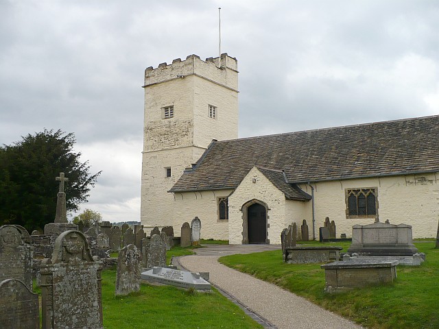
1377:== {{int:filedesc}} == {{Information |description={{en|1=St Sannan's Church, Bedwellty This church, dating from the 13th century, is prominently situated at 300m on a ridgeway. For some historical information on the Parish of Bedwellty see http://freepage
437:– You must give appropriate credit, provide a link to the license, and indicate if changes were made. You may do so in any reasonable manner, but not in any way that suggests the licensor endorses you or your use.
83:
51:
309:
259:
153:
St Sannan's Church, Bedwellty This church, dating from the 13th century, is prominently situated at 300m on a ridgeway. For some historical information on the Parish of
Bedwellty see
746:
738:
694:
650:
496:
754:
1279:
963:
559:
1237:
1199:
1154:
1116:
1071:
1007:
1003:
959:
895:
891:
742:
734:
646:
555:
547:
543:
551:
853:
762:
758:
750:
690:
539:
492:
1275:
1396:
1370:
697:"}},"text\/plain":{"en":{"P275":"Creative Commons Attribution-ShareAlike 2.0 Generic"}}}}": -->
1558:
765:"}},"text\/plain":{"en":{"P973":"https:\/\/www.geograph.org.uk\/photo\/605453"}}}}": -->
1359:
1354:
42:
788:
720:
676:
525:
319:
269:
823:
354:
1452:
This file contains additional information, probably added from the digital camera or scanner used to create or digitize it.
1305:
989:
444:
631:
1247:
1209:
1168:
1126:
1085:
1048:
1021:
973:
936:
909:
801:
772:
660:
624:
609:
596:
863:
831:
816:
704:
569:
509:
122:
1289:
966:"}},"text\/plain":{"en":{"P1071":"Caerphilly County Borough"}}}}": -->
1589:
400:
1455:
If the file has been modified from its original state, some details may not fully reflect the modified file.
499:"}},"text\/plain":{"en":{"P180":"St Sannan's Church"}}}}": -->
1161:"}},"text\/plain":{"en":{"P2151":"6.1 millimetre"}}}}": -->
443:– If you remix, transform, or build upon the material, you must distribute your contributions under the
361:
on the
Geograph website for the photographer's contact details. The copyright on this image is owned by
1078:"}},"text\/plain":{"en":{"P6757":"0.0025 second"}}}}": -->
562:"}},"text\/plain":{"en":{"P3831":"photographer"}}}}": -->
117:
653:"}},"text\/plain":{"en":{"P6216":"copyrighted"}}}}": -->
154:
1387:
The following pages on the
English Knowledge use this file (pages on other projects are not listed):
1014:"}},"text\/plain":{"en":{"P7787":"337 degree"}}}}": -->
902:"}},"text\/plain":{"en":{"P7787":"337 degree"}}}}": -->
1282:"}},"text\/plain":{"en":{"P31":"photograph"}}}}": -->
91:
214:
1616:
616:
838:
808:
397:
198:
8:
1652:
341:
325:
275:
1733:
366:
78:
1696:
1634:
1481:
187:
1743:
1706:
1521:
177:
1299:
1257:
1219:
1178:
1136:
1095:
1031:
983:
919:
873:
782:
714:
670:
579:
519:
1662:
346:
1501:
1464:
1391:
358:
1753:
1491:
1327:
Click on a date/time to view the file as it appeared at that time.
1474:
155:
http://freepages.genealogy.rootsweb.com/~familyalbum/kedwelty.htm
311:
261:
52:
St_Sannan's_Church,_Bedwellty_-_geograph.org.uk_-_605453.jpg
109:
143:
St Sannan's Church, Bedwellty - geograph.org.uk - 605453.jpg
296:
51° 41′ 43″ N, 3° 12′ 28″ W
246:
51° 41′ 41″ N, 3° 12′ 27″ W
166:
66:
1397:
Grade II* listed buildings in
Caerphilly County Borough
485:
Add a one-line explanation of what this file represents
1439:
1424:
1414:
1434:
1385:
1405:
1325:
90:
Commons is a freely licensed media file repository.
721:
Creative
Commons Attribution-ShareAlike 2.0 Generic
695:
Creative
Commons Attribution-ShareAlike 2.0 Generic
56:(640 × 480 pixels, file size: 115 KB, MIME type:
1657:Flash did not fire, compulsory flash suppression
454:https://creativecommons.org/licenses/by-sa/2.0
71:
552:https:\/\/www.geograph.org.uk\/profile\/15303
460:Creative Commons Attribution-Share Alike 2.0
378:
162:
140:
763:https:\/\/www.geograph.org.uk\/photo\/605453
183:
172:
14:
1158:
1075:
1011:
899:
420:– to copy, distribute and transmit the work
1407:The following other wikis use this file:
617:https://www.geograph.org.uk/profile/15303
839:https://www.geograph.org.uk/photo/605453
318:View this and other nearby images on:
268:View this and other nearby images on:
221:
102:
365:and is licensed for reuse under the
286:
236:
1318:
401:Attribution-Share Alike 2.0 Generic
389:
384:
369:Attribution-ShareAlike 2.0 license.
13:
1450:
490:
484:
375:
352:
147:
115:
103:
49:
1770:
1457:
489:
1512:Date and time of data generation
1386:
910:coordinates of the point of view
892:coordinates of the point of view
475:
431:Under the following conditions:
396:This file is licensed under the
388:
383:
377:
345:
324:
310:
302:
274:
260:
252:
108:
70:
31:
21:
472:
148:
46:No higher resolution available.
1402:
1322:
789:file available on the internet
739:file available on the internet
471:
353:This image was taken from the
26:
1:
1022:coordinates of depicted place
1004:coordinates of depicted place
229:St Sannan's Church, Bedwellty
210:St Sannan's Church, Bedwellty
36:
1382:
824:Geograph Britain and Ireland
755:Geograph Britain and Ireland
625:object of statement has role
556:object of statement has role
505:Items portrayed in this file
337:
301:
251:
7:
1600:Date and time of digitizing
1447:
1037:51°41'43.33"N, 3°12'27.72"W
925:51°41'41.06"N, 3°12'27.00"W
10:
1775:
1717:Focal length in 35 mm film
1675:One-chip color area sensor
1431:Usage on www.wikidata.org
1421:Usage on eu.wikipedia.org
1411:Usage on cy.wikipedia.org
445:same or compatible license
227:Robin Drayton /
208:Robin Drayton /
137:
132:
104:
1565:File change date and time
1319:
990:Caerphilly County Borough
964:Caerphilly County Borough
16:
1603:15:15, 27 September 2007
1568:15:15, 27 September 2007
1515:15:15, 27 September 2007
802:geograph.org.uk image ID
743:geograph.org.uk image ID
474:
411:
77:This is a file from the
41:
1680:Custom image processing
1376:
199:required by the license
165:
81:. Information from its
1608:Image compression mode
1355:00:24, 7 February 2011
359:this photograph's page
330:51.695370; -3.207700
280:51.694740; -3.207500
84:description page there
1626:Maximum land aperture
1539:Horizontal resolution
974:location of creation
960:location of creation
1573:Y and C positioning
1547:Vertical resolution
1461:Camera manufacturer
426:– to adapt the work
116:This is a photo of
1725:Scene capture type
1701:Auto white balance
1486:1/400 sec (0.0025)
597:author name string
544:author name string
526:St Sannan's Church
497:St Sannan's Church
1762:
1761:
1403:Global file usage
1380:
1160:
1077:
1013:
901:
879:27 September 2007
705:copyright license
691:copyright license
483:
374:
373:
357:collection. See
335:
334:
285:
284:
234:
233:
202:
167:27 September 2007
130:
129:
99:
98:
79:Wikimedia Commons
32:Global file usage
1766:
1581:Exposure Program
1458:
1367:
1329:
1187:
1104:
1059:
1058:
1053:
947:
946:
941:
841:
836:
832:described at URL
826:
821:
811:
806:
759:described at URL
661:copyright status
647:copyright status
634:
629:
619:
614:
604:
601:
481:
467:
464:
461:
458:
455:
447:as the original.
409:
398:Creative Commons
392:
391:
387:
386:
381:
380:
367:Creative Commons
355:Geograph project
349:
342:
331:
328:
314:
313:
307:
306:
305:
299:
298:
287:
281:
278:
264:
263:
257:
256:
255:
249:
248:
237:
196:
168:
152:
144:
138:
112:
105:
95:
74:
73:
67:
61:
59:
1774:
1773:
1769:
1768:
1767:
1765:
1764:
1763:
1629:3 APEX (f/2.83)
1446:
1401:
1388:
1381:
1373:
1365:
1321:
1320:
1317:
1316:
1315:
1314:
1313:
1312:
1311:
1310:
1308:
1296:
1295:
1294:
1292:
1273:
1272:
1271:
1270:
1269:
1268:
1267:
1266:
1264:
1254:
1253:
1252:
1250:
1235:
1234:
1233:
1232:
1231:
1230:
1229:
1228:
1226:
1216:
1215:
1214:
1212:
1197:
1196:
1195:
1194:
1193:
1192:
1191:
1190:
1188:
1185:
1175:
1174:
1173:
1171:
1152:
1151:
1150:
1149:
1148:
1147:
1146:
1145:
1143:
1133:
1132:
1131:
1129:
1114:
1113:
1112:
1111:
1110:
1109:
1108:
1107:
1105:
1102:
1092:
1091:
1090:
1088:
1069:
1068:
1067:
1066:
1065:
1064:
1063:
1062:
1061:
1060:
1056:
1054:
1051:
1042:
1041:
1040:
1038:
1028:
1027:
1026:
1024:
1001:
1000:
999:
998:
997:
996:
995:
994:
992:
980:
979:
978:
976:
957:
956:
955:
954:
953:
952:
951:
950:
949:
948:
944:
942:
939:
930:
929:
928:
926:
916:
915:
914:
912:
889:
888:
887:
886:
885:
884:
883:
882:
880:
870:
869:
868:
866:
851:
850:
849:
848:
847:
846:
845:
844:
843:
842:
837:
834:
828:
827:
822:
819:
813:
812:
807:
804:
795:
794:
793:
791:
779:
778:
777:
775:
732:
731:
730:
729:
728:
727:
726:
725:
723:
711:
710:
709:
707:
688:
687:
686:
685:
684:
683:
682:
681:
679:
667:
666:
665:
663:
644:
643:
642:
641:
640:
639:
638:
637:
636:
635:
630:
627:
621:
620:
615:
612:
606:
605:
602:
599:
590:
589:
588:
586:
576:
575:
574:
572:
537:
536:
535:
534:
533:
532:
531:
530:
528:
516:
515:
514:
512:
488:
487:
486:
469:
468:
465:
462:
459:
456:
453:
452:
410:
407:
404:
393:
370:
340:
329:
303:
294:
293:
290:Object location
279:
253:
244:
243:
240:Camera location
235:
224:
217:
205:
178:geograph.org.uk
158:
142:
135:
121:
118:listed building
101:
100:
89:
88:
87:is shown below.
63:
57:
55:
48:
47:
12:
11:
5:
1772:
1760:
1759:
1756:
1750:
1749:
1746:
1740:
1739:
1736:
1730:
1729:
1726:
1722:
1721:
1718:
1714:
1713:
1710:
1703:
1702:
1699:
1693:
1692:
1689:
1685:
1684:
1683:Normal process
1681:
1677:
1676:
1673:
1672:Sensing method
1669:
1668:
1665:
1659:
1658:
1655:
1649:
1648:
1645:
1641:
1640:
1637:
1631:
1630:
1627:
1623:
1622:
1619:
1613:
1612:
1609:
1605:
1604:
1601:
1597:
1596:
1593:
1586:
1585:
1584:Normal program
1582:
1578:
1577:
1574:
1570:
1569:
1566:
1562:
1561:
1556:
1552:
1551:
1548:
1544:
1543:
1540:
1536:
1535:
1532:
1528:
1527:
1524:
1517:
1516:
1513:
1509:
1508:
1505:
1498:
1497:
1494:
1488:
1487:
1484:
1478:
1477:
1472:
1468:
1467:
1462:
1449:
1445:
1444:
1443:
1442:
1437:
1429:
1428:
1427:
1419:
1418:
1417:
1404:
1400:
1399:
1394:
1384:
1379:
1378:
1375:
1371:
1368:
1362:
1357:
1352:
1348:
1347:
1344:
1341:
1338:
1335:
1332:
1324:
1309:
1304:
1302:
1301:
1300:
1298:
1297:
1293:
1288:
1286:
1285:
1284:
1283:
1281:
1277:
1265:
1262:
1260:
1259:
1258:
1256:
1255:
1251:
1246:
1244:
1243:
1242:
1241:
1239:
1227:
1224:
1222:
1221:
1220:
1218:
1217:
1213:
1208:
1206:
1205:
1204:
1203:
1201:
1189:
1183:
1181:
1180:
1179:
1177:
1176:
1172:
1167:
1165:
1164:
1163:
1162:
1156:
1144:
1141:
1139:
1138:
1137:
1135:
1134:
1130:
1125:
1123:
1122:
1121:
1120:
1118:
1106:
1100:
1098:
1097:
1096:
1094:
1093:
1089:
1084:
1082:
1081:
1080:
1079:
1073:
1047:
1046:
1045:
1044:
1043:
1039:
1036:
1034:
1033:
1032:
1030:
1029:
1025:
1020:
1018:
1017:
1016:
1015:
1009:
1005:
993:
988:
986:
985:
984:
982:
981:
977:
972:
970:
969:
968:
967:
965:
961:
935:
934:
933:
932:
931:
927:
924:
922:
921:
920:
918:
917:
913:
908:
906:
905:
904:
903:
897:
893:
881:
878:
876:
875:
874:
872:
871:
867:
862:
860:
859:
858:
857:
855:
830:
829:
815:
814:
800:
799:
798:
797:
796:
792:
787:
785:
784:
783:
781:
780:
776:
773:source of file
771:
769:
768:
767:
766:
764:
760:
756:
752:
748:
744:
740:
736:
735:source of file
724:
719:
717:
716:
715:
713:
712:
708:
703:
701:
700:
699:
698:
696:
692:
680:
675:
673:
672:
671:
669:
668:
664:
659:
657:
656:
655:
654:
652:
648:
623:
622:
608:
607:
595:
594:
593:
592:
591:
587:
584:
582:
581:
580:
578:
577:
573:
568:
566:
565:
564:
563:
561:
557:
553:
549:
545:
541:
529:
524:
522:
521:
520:
518:
517:
513:
508:
506:
503:
502:
501:
500:
498:
494:
480:
479:
476:
473:
451:
450:
449:
448:
438:
429:
428:
427:
421:
414:You are free:
405:
395:
394:
376:
372:
371:
350:
339:
336:
333:
332:
322:
316:
291:
283:
282:
272:
266:
241:
232:
231:
225:
222:
219:
218:
213:
206:
203:
191:
190:
185:
181:
180:
174:
170:
169:
164:
160:
159:
145:
136:
134:
131:
128:
127:
113:
97:
96:
75:
65:
64:
45:
40:
39:
34:
29:
24:
19:
9:
6:
4:
3:
2:
1771:
1757:
1755:
1752:
1751:
1747:
1745:
1742:
1741:
1737:
1735:
1732:
1731:
1727:
1724:
1723:
1719:
1716:
1715:
1711:
1708:
1705:
1704:
1700:
1698:
1697:White balance
1695:
1694:
1691:Auto exposure
1690:
1688:Exposure mode
1687:
1686:
1682:
1679:
1678:
1674:
1671:
1670:
1666:
1664:
1661:
1660:
1656:
1654:
1651:
1650:
1646:
1643:
1642:
1638:
1636:
1635:Metering mode
1633:
1632:
1628:
1625:
1624:
1620:
1618:
1617:Exposure bias
1615:
1614:
1610:
1607:
1606:
1602:
1599:
1598:
1594:
1591:
1588:
1587:
1583:
1580:
1579:
1575:
1572:
1571:
1567:
1564:
1563:
1560:
1557:
1555:Software used
1554:
1553:
1549:
1546:
1545:
1541:
1538:
1537:
1533:
1530:
1529:
1525:
1523:
1519:
1518:
1514:
1511:
1510:
1506:
1503:
1500:
1499:
1495:
1493:
1490:
1489:
1485:
1483:
1482:Exposure time
1480:
1479:
1476:
1473:
1470:
1469:
1466:
1463:
1460:
1459:
1456:
1453:
1441:
1438:
1436:
1433:
1432:
1430:
1426:
1423:
1422:
1420:
1416:
1413:
1412:
1410:
1409:
1408:
1398:
1395:
1393:
1390:
1389:
1374:
1369:
1363:
1361:
1358:
1356:
1353:
1350:
1349:
1345:
1342:
1339:
1336:
1333:
1331:
1330:
1328:
1307:
1303:
1291:
1287:
1261:
1249:
1245:
1223:
1211:
1207:
1182:
1170:
1166:
1140:
1128:
1124:
1099:
1087:
1086:exposure time
1083:
1072:exposure time
1050:
1035:
1023:
1019:
991:
987:
975:
971:
938:
923:
911:
907:
877:
865:
861:
840:
833:
825:
818:
810:
803:
790:
786:
774:
770:
722:
718:
706:
702:
678:
674:
662:
658:
633:
626:
618:
611:
603:Robin Drayton
598:
583:
571:
567:
527:
523:
511:
507:
504:
477:
470:
457:CC BY-SA 2.0
446:
442:
439:
436:
433:
432:
430:
425:
422:
419:
416:
415:
413:
412:
408:Robin Drayton
406:Attribution:
402:
399:
382:
368:
364:
363:Robin Drayton
360:
356:
351:
348:
344:
343:
327:
323:
321:
320:OpenStreetMap
317:
315:
297:
292:
289:
288:
277:
273:
271:
270:OpenStreetMap
267:
265:
247:
242:
239:
238:
230:
226:
220:
216:
212: /
211:
207:
200:
195:
193:
192:
189:
188:Robin Drayton
186:
182:
179:
175:
171:
161:
156:
151:
146:
139:
126:
124:
119:
114:
111:
107:
106:
93:
86:
85:
80:
76:
69:
68:
62:
53:
44:
38:
35:
33:
30:
28:
25:
23:
20:
18:
15:
1707:Digital zoom
1644:Light source
1522:focal length
1471:Camera model
1454:
1451:
1406:
1326:
1323:File history
1169:focal length
1155:focal length
632:photographer
560:photographer
440:
434:
423:
417:
362:
300:
250:
228:
215:CC BY-SA 2.0
209:
149:
92:You can help
82:
50:
22:File history
1663:Color space
1531:Orientation
1372:GeographBot
1290:instance of
1276:instance of
677:copyrighted
651:copyrighted
441:share alike
435:attribution
194:Attribution
141:Description
1744:Saturation
1383:File usage
1364:640 × 480
1340:Dimensions
1306:photograph
1280:photograph
1263:image/jpeg
1248:media type
1238:media type
1186:millimetre
1159:millimetre
585:some value
58:image/jpeg
27:File usage
1754:Sharpness
1559:Ver.1.0
1502:ISO speed
1465:Panasonic
1440:Q17739796
1425:Bedwellty
1415:Bedwellte
1392:Bedwellty
1337:Thumbnail
1334:Date/Time
1210:ISO speed
1200:ISO speed
864:inception
854:inception
338:Licensing
223:InfoField
204:InfoField
150:English:
1734:Contrast
1728:Standard
1576:Co-sited
1492:F-number
1448:Metadata
1435:Q4879473
1366:(115 KB)
1127:f-number
1117:f-number
817:operator
751:operator
478:Captions
424:to remix
418:to share
403:license.
37:Metadata
1647:Unknown
1639:Pattern
1592:version
1475:DMC-LZ7
1351:current
1346:Comment
1101:0.0025
1049:heading
1008:heading
937:heading
896:heading
570:creator
540:creator
510:depicts
493:depicts
482:English
133:Summary
54:
1758:Normal
1748:Normal
1738:Normal
1550:72 dpi
1542:72 dpi
1534:Normal
1526:6.1 mm
1504:rating
1103:second
1076:second
1057:degree
1012:degree
945:degree
900:degree
809:605453
747:605453
308:
258:
184:Author
173:Source
120:number
1720:37 mm
1709:ratio
1653:Flash
1520:Lens
1496:f/2.8
176:From
123:25522
1667:sRGB
1595:2.21
1590:Exif
1343:User
1184:6.1
1055:337
943:337
466:true
463:true
163:Date
17:File
1507:100
1225:100
1142:2.8
610:URL
548:URL
1052::
940::
835::
820::
805::
628::
613::
600::
1712:0
1621:0
1611:4
201:)
197:(
157:.
125:.
94:.
60:)
Text is available under the Creative Commons Attribution-ShareAlike License. Additional terms may apply.
_heading:337.00&language=en)
_heading:337.00&language=en)
