342:
363:
442:
264:
95:
462:"}},"text\/plain":{"en":{"":"determination method"}}},"{\"value\":{\"entity-type\":\"item\",\"numeric-id\":60671452,\"id\":\"Q60671452\"},\"type\":\"wikibase-entityid\"}":{"text\/html":{"en":{"P459":"
458:"}},"text\/plain":{"en":{"P1001":"United States of America"}}},"{\"value\":{\"entity-type\":\"property\",\"numeric-id\":459,\"id\":\"P459\"},\"type\":\"wikibase-entityid\"}":{"text\/html":{"en":{"":"
454:"}},"text\/plain":{"en":{"":"applies to jurisdiction"}}},"{\"value\":{\"entity-type\":\"item\",\"numeric-id\":30,\"id\":\"Q30\"},\"type\":\"wikibase-entityid\"}":{"text\/html":{"en":{"P1001":"
446:"}},"text\/plain":{"en":{"":"copyright status"}}},"{\"value\":{\"entity-type\":\"item\",\"numeric-id\":19652,\"id\":\"Q19652\"},\"type\":\"wikibase-entityid\"}":{"text\/html":{"en":{"P6216":"
450:"}},"text\/plain":{"en":{"P6216":"public domain"}}},"{\"value\":{\"entity-type\":\"property\",\"numeric-id\":1001,\"id\":\"P1001\"},\"type\":\"wikibase-entityid\"}":{"text\/html":{"en":{"":"
399:"}},"text\/plain":{"en":{"":"depicts"}}},"{\"value\":{\"entity-type\":\"item\",\"numeric-id\":56522929,\"id\":\"Q56522929\"},\"type\":\"wikibase-entityid\"}":{"text\/html":{"en":{"P180":"
395:
144:
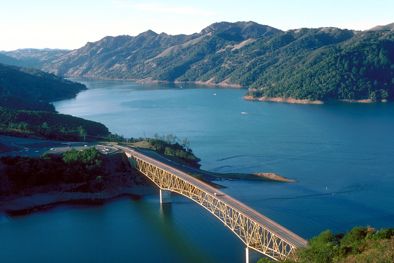
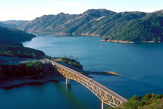
Aerial view of Lake Sonoma on Dry Creek in Sonoma County, California, USA. The lake is impounded by Warm
Springs Dam, constructed in 1983 by the U.S. Army Corps of Engineers for flood control and water supply. The dam is just off to the right and is not visible in this picture. View is to the
597:{{Information | Description = {{en|Aerial view of Lake Sonoma on Dry Creek in Sonoma County, California, USA. The lake is impounded by Warm Springs Dam, constructed in 1983 by the U.S. Army Corps of Engineers for flood control and water supply. The dam
208:
463:
400:
447:
451:
443:
459:
396:
455:
149:
626:
466:"}},"text\/plain":{"en":{"P459":"work of the federal government of the United States"}}}}": -->
616:
231:
61:
57:
53:
47:
280:
621:
106:
636:
74:
524:
429:
276:
717:
This file contains additional information, probably added from the digital camera or scanner used to create or digitize it.
489:
332:
502:
473:
517:
413:
509:
403:"}},"text\/plain":{"en":{"P180":"Warm Springs Creek Bridge"}}}}": -->
631:
720:
If the file has been modified from its original state, some details may not fully reflect the modified file.
272:
607:
The following pages on the
English Knowledge use this file (pages on other projects are not listed):
114:
579:
574:
65:
42:
315:
327:
323:
319:
311:
307:
303:
299:
295:
8:
204:
101:
275:
soldier or employee, taken or made as part of that person's official duties. As a
362:
285:
164:
151:
611:
483:
423:
590:
547:
Click on a date/time to view the file as it appeared at that time.
222:
U.S. Army Corps of
Engineers, photographer not specified or unknown
212:
674:
694:
654:
89:
664:
684:
389:
Add a one-line explanation of what this file represents
704:
605:
79:(1,500 × 1,001 pixels, file size: 542 KB, MIME type:
645:
545:
113:
Commons is a freely licensed media file repository.
525:
work of the federal government of the United States
464:
work of the federal government of the United States
202:
U.S. Army Corps of
Engineers Digital Visual Library
94:
627:List of longest continuous truss bridge spans
226:
190:
131:
354:
218:
198:
14:
617:List of lakes of the San Francisco Bay Area
647:The following other wikis use this file:
622:List of largest reservoirs of California
637:Knowledge:WikiProject Lakes/Galleries/3
263:
125:
729:File written by Adobe Photoshop¨ 5.0
258:
538:
13:
715:
394:
388:
340:
271:This image or file is a work of a
269:
138:
126:
72:
741:
722:
393:
606:
379:
361:
262:
213:Digital Visual Library home page
93:
31:
21:
376:
139:
642:
632:Local government in California
542:
375:
186:Sonoma County, California, USA
26:
1:
36:
602:
409:Items portrayed in this file
273:U.S. Army Corps of Engineers
7:
712:
134:Sonoma Lake aerial view.jpg
10:
746:
701:Usage on www.wikidata.org
691:Usage on sk.wikipedia.org
681:Usage on fr.wikipedia.org
671:Usage on et.wikipedia.org
661:Usage on es.wikipedia.org
651:Usage on de.wikipedia.org
128:
539:
430:Warm Springs Creek Bridge
401:Warm Springs Creek Bridge
16:
510:United States of America
456:United States of America
378:
194:not specified or unknown
100:This is a file from the
41:
596:
503:applies to jurisdiction
452:applies to jurisdiction
281:U.S. federal government
193:
165:38.7189°N 123.0132278°W
104:. Information from its
345:
283:, the image is in the
209:Image description page
107:description page there
46:Size of this preview:
344:
170:38.7189; -123.0132278
518:determination method
460:determination method
66:1,500 × 1,001 pixels
52:Other resolutions:
346:
62:1,024 × 683 pixels
733:
732:
726:JPEG file comment
643:Global file usage
600:
575:03:32, 4 May 2007
387:
372:
371:
350:
349:
335:
257:
256:
235:
232:Reusing this file
122:
121:
102:Wikimedia Commons
32:Global file usage
737:
723:
587:
549:
527:
522:
512:
507:
474:copyright status
444:copyright status
385:
365:
343:
336:
331:
266:
265:
259:
253:
250:
247:
244:
239:
238:
229:
175:
173:
172:
171:
166:
162:
161:
158:
157:
154:
143:
135:
129:
118:
97:
96:
90:
84:
82:
69:
58:640 × 427 pixels
54:320 × 214 pixels
48:800 × 534 pixels
745:
744:
740:
739:
738:
736:
735:
734:
711:
641:
608:
601:
593:
585:
541:
540:
537:
536:
535:
534:
533:
532:
531:
530:
529:
528:
523:
520:
514:
513:
508:
505:
496:
495:
494:
492:
480:
479:
478:
476:
441:
440:
439:
438:
437:
436:
435:
434:
432:
420:
419:
418:
416:
392:
391:
390:
373:
366:
341:
294:
291:
251:
248:
245:
242:
183:
169:
167:
163:
159:
155:
152:
150:
148:
146:
133:
124:
123:
112:
111:
110:is shown below.
86:
80:
78:
71:
70:
51:
12:
11:
5:
743:
731:
730:
727:
714:
710:
709:
708:
707:
699:
698:
697:
689:
688:
687:
679:
678:
677:
675:Sonoma maakond
669:
668:
667:
659:
658:
657:
644:
640:
639:
634:
629:
624:
619:
614:
604:
599:
598:
595:
591:
588:
584:1,500 × 1,001
582:
577:
572:
568:
567:
564:
561:
558:
555:
552:
544:
516:
515:
501:
500:
499:
498:
497:
493:
488:
486:
485:
484:
482:
481:
477:
472:
470:
469:
468:
467:
465:
461:
457:
453:
449:
445:
433:
428:
426:
425:
424:
422:
421:
417:
412:
410:
407:
406:
405:
404:
402:
398:
384:
383:
380:
377:
370:
369:
368:
367:
360:
356:
355:Other versions
352:
351:
348:
347:
338:
267:
255:
254:
236:
224:
223:
220:
216:
215:
200:
196:
195:
192:
188:
187:
184:
181:
177:
176:
136:
127:
120:
119:
98:
88:
87:
45:
40:
39:
34:
29:
24:
19:
9:
6:
4:
3:
2:
742:
728:
725:
724:
721:
718:
706:
703:
702:
700:
696:
695:Sonoma County
693:
692:
690:
686:
683:
682:
680:
676:
673:
672:
670:
666:
663:
662:
660:
656:
655:Sonoma County
653:
652:
650:
649:
648:
638:
635:
633:
630:
628:
625:
623:
620:
618:
615:
613:
610:
609:
594:
589:
583:
581:
578:
576:
573:
570:
569:
565:
562:
559:
556:
553:
551:
550:
548:
526:
519:
511:
504:
491:
490:public domain
487:
475:
471:
448:public domain
431:
427:
415:
411:
408:
381:
374:
364:
359:
358:
357:
353:
339:
337:
334:
329:
325:
321:
317:
313:
309:
305:
301:
297:
292:
290:
288:
287:
286:public domain
282:
278:
274:
268:
261:
260:
246:Public domain
243:Public domain
241:
240:
237:
233:
228:
225:
221:
217:
214:
211:
210:
207:
206:
203:
201:
197:
189:
185:
179:
178:
174:
156:123°0′47.62″W
147:Coordinates:
142:
137:
130:
116:
109:
108:
103:
99:
92:
91:
85:
76:
75:Original file
67:
63:
59:
55:
49:
44:
38:
35:
33:
30:
28:
25:
23:
20:
18:
15:
719:
716:
646:
546:
543:File history
293:
284:
270:
153:38°43′8.04″N
140:
115:You can help
105:
73:
22:File history
665:Lago Sonoma
612:Lake Sonoma
320:slovenščina
132:Description
685:Lac Sonoma
603:File usage
560:Dimensions
328:українська
304:Nederlands
227:Permission
205:Image page
145:northwest.
81:image/jpeg
27:File usage
557:Thumbnail
554:Date/Time
316:sicilianu
182:InfoField
141:English:
713:Metadata
705:Q6477806
586:(542 KB)
382:Captions
330: |
326: |
322: |
318: |
314: |
310: |
306: |
302: |
300:italiano
298: |
180:Location
37:Metadata
571:current
566:Comment
414:depicts
397:depicts
386:English
312:русский
296:English
279:of the
77:
324:Türkçe
219:Author
199:Source
592:DanMS
252:false
249:false
563:User
308:پښتو
277:work
191:Date
17:File
333:+/−
160:/
521::
506::
168:/
64:|
60:|
56:|
50:.
289:.
234:)
230:(
117:.
83:)
68:.
Text is available under the Creative Commons Attribution-ShareAlike License. Additional terms may apply.