925:"}},"text\/plain":{"en":{"":"coordinates of the point of view"}}},"{\"value\":{\"latitude\":18.068611,\"longitude\":-63.0625,\"altitude\":null,\"precision\":1.0e-6,\"globe\":\"http:\\\/\\\/www.wikidata.org\\\/entity\\\/Q2\"},\"type\":\"globecoordinate\"}":{"text\/html":{"en":{"P1259":"18\u00b04'7.000"N, 63\u00b03'45.000"W"}},"text\/plain":{"en":{"P1259":"18\u00b04'7.000\"N, 63\u00b03'45.000\"W"}}}}": -->
368:
392:
843:"}},"text\/plain":{"en":{"":"inception"}}},"{\"value\":{\"time\":\"+2009-01-01T00:00:00Z\",\"timezone\":0,\"before\":0,\"after\":0,\"precision\":10,\"calendarmodel\":\"http:\\\/\\\/www.wikidata.org\\\/entity\\\/Q1985727\"},\"type\":\"time\"}":{"text\/html":{"en":{"P571":"January 2009"}},"text\/plain":{"en":{"P571":"January 2009"}}}}": -->
380:
600:
150:
512:
164:
427:
43:
432:
95:
782:"}},"text\/plain":{"en":{"P275":"GNU Free Documentation License, version 1.2 or later"}}},"{\"value\":{\"entity-type\":\"item\",\"numeric-id\":14946043,\"id\":\"Q14946043\"},\"type\":\"wikibase-entityid\"}":{"text\/html":{"en":{"P275":"
620:"}},"text\/plain":{"en":{"P2093":"Sting","P4174":"Sting"}}},"{\"value\":{\"entity-type\":\"property\",\"numeric-id\":4174,\"id\":\"P4174\"},\"type\":\"wikibase-entityid\"}":{"text\/html":{"en":{"":"
608:"}},"text\/plain":{"en":{"":"object of statement has role"}}},"{\"value\":{\"entity-type\":\"item\",\"numeric-id\":33231,\"id\":\"Q33231\"},\"type\":\"wikibase-entityid\"}":{"text\/html":{"en":{"P3831":"
1031:
778:"}},"text\/plain":{"en":{"":"copyright license"}}},"{\"value\":{\"entity-type\":\"item\",\"numeric-id\":50829104,\"id\":\"Q50829104\"},\"type\":\"wikibase-entityid\"}":{"text\/html":{"en":{"P275":"
734:"}},"text\/plain":{"en":{"":"copyright status"}}},"{\"value\":{\"entity-type\":\"item\",\"numeric-id\":50423863,\"id\":\"Q50423863\"},\"type\":\"wikibase-entityid\"}":{"text\/html":{"en":{"P6216":"
881:"}},"text\/plain":{"en":{"":"source of file"}}},"{\"value\":{\"entity-type\":\"item\",\"numeric-id\":66458942,\"id\":\"Q66458942\"},\"type\":\"wikibase-entityid\"}":{"text\/html":{"en":{"P7482":"
624:"}},"text\/plain":{"en":{"":"Wikimedia username"}}},"{\"value\":{\"entity-type\":\"property\",\"numeric-id\":2699,\"id\":\"P2699\"},\"type\":\"wikibase-entityid\"}":{"text\/html":{"en":{"":"
612:"}},"text\/plain":{"en":{"P3831":"photographer"}}},"{\"value\":{\"entity-type\":\"property\",\"numeric-id\":2093,\"id\":\"P2093\"},\"type\":\"wikibase-entityid\"}":{"text\/html":{"en":{"":"
604:"}},"text\/plain":{"en":{"":"creator"}}},"{\"value\":{\"entity-type\":\"property\",\"numeric-id\":3831,\"id\":\"P3831\"},\"type\":\"wikibase-entityid\"}":{"text\/html":{"en":{"":"
921:
839:
473:– You must give appropriate credit, provide a link to the license, and indicate if changes were made. You may do so in any reasonable manner, but not in any way that suggests the licensor endorses you or your use.
147:
617:
1451:
61:
57:
53:
47:
882:
783:
779:
735:
106:
74:
629:
609:
922:
878:
731:
625:
621:
613:
605:
840:
775:
601:
529:
1094:
1162:
391:
379:
786:"}},"text\/plain":{"en":{"P275":"Creative Commons Attribution-ShareAlike 3.0 Unported"}}}}": -->
1030:
1025:
1347:
632:"}},"text\/plain":{"en":{"P2699":"http:\/\/commons.wikimedia.org\/wiki\/User:Sting"}}}}": -->
527:; with no Invariant Sections, no Front-Cover Texts, and no Back-Cover Texts. A copy of the license is included in the section entitled
325:
1104:
1048:== Summary == {{Location|18|04|07|N|63|03|45|W|scale:100000}} <br/> {{Information |Description={{en|Blank physical map of the
219:
367:
908:
826:
809:
761:
157:
1099:
1462:
This file contains additional information, probably added from the digital camera or scanner used to create or digitize it.
480:
673:
347:) as the author and distribute the copies and derivative works under the same license(s) that the one(s) stated below. A
932:
892:
745:
709:
694:
681:
666:
885:"}},"text\/plain":{"en":{"P7482":"original creation by uploader"}}}}": -->
519:
850:
793:
639:
590:
1402:
1000:
995:
65:
42:
215:
1412:
348:
442:
1352:
1465:
If the file has been modified from its original state, some details may not fully reflect the modified file.
1192:
701:
1147:
524:
230:
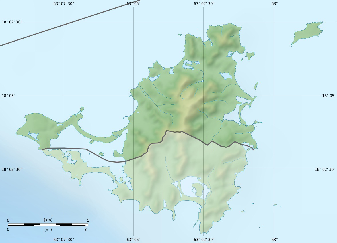
Scales: 1:372,000 (precision: 93 m) for the topography; 1:7,412,000 (precision: 1,853 m) for the bathymetry
1417:
479:– If you remix, transform, or build upon the material, you must distribute your contributions under the
1142:
738:"}},"text\/plain":{"en":{"P6216":"copyrighted"}}}}": -->
1070:
The following pages on the
English Knowledge use this file (pages on other projects are not listed):
1242:
114:
199:
195:
1362:
1132:
1053:
1049:
517:
Permission is granted to copy, distribute and/or modify this document under the terms of the
716:
439:
313:
298:
Shorelines, lakes, ponds and streams: created from
Landsat 7 ETM+ imagery (public domain).
290:
Topography : NASA Shuttle Radar
Topography Mission (SRTM3 v.2) (public domain) ;
8:
1498:
1407:
1084:
163:
1172:
1337:
1257:
414:
I, the copyright holder of this work, hereby publish it under the following licenses:
101:
1387:
1089:
580:
1074:
1202:
1372:
1222:
1182:
1157:
1122:
1317:
1247:
1252:
1348:
Wikiproyecto:Ilustración/Taller de
Cartografía/Realizaciones/América del Norte
1397:
1312:
1513:
1079:
942:
902:
860:
820:
803:
755:
649:
309:
1437:
1432:
1041:
1011:
343:
Any use of this map can be made as long as you credit me (Eric Gaba –
1427:
223:
1297:
506:
1422:
1392:
1232:
968:
Click on a date/time to view the file as it appeared at that time.
203:
1382:
149:
1237:
1057:
1277:
385:
Administrative location map of the southern part of the island
1282:
344:
1307:
1442:
142:
18° 04′ 07″ N, 63° 03′ 45″ W
1403:
Modèle:Géolocalisation/Saint-Martin (Antilles françaises)
1332:
1327:
1302:
1272:
89:
1292:
1287:
1212:
1207:
397:
Physical location map of the southern part of the island
351:
with a reply address would also be greatly appreciated.
1262:
574:
Add a one-line explanation of what this file represents
1418:
Wikipédia:Atelier graphique/Cartes/Archives/avril 2010
1353:
Plantilla:Mapa de localización de San Martín (Francia)
273:
1243:
Knowledge:Kartenwerkstatt/Positionskarten/Nordamerika
1068:
1413:
Modèle:Géolocdual/Saint-Martin (Antilles françaises)
1113:
966:
827:
Creative
Commons Attribution-ShareAlike 3.0 Unported
810:
784:
Creative
Commons Attribution-ShareAlike 3.0 Unported
780:
523:, Version 1.2 or any later version published by the
113:
Commons is a freely licensed media file repository.
1148:
Módulu:Mapa de llocalización/datos/Saint-Martin/usu
1095:
User:Michael!/Project:Location map templates/France
79:(1,175 × 849 pixels, file size: 167 KB, MIME type:
184:Saint-Martin collectivity relief location map.jpg
630:http:\/\/commons.wikimedia.org\/wiki\/User:Sting
1143:Módulu:Mapa de llocalización/datos/Saint-Martin
490:https://creativecommons.org/licenses/by-sa/3.0
294:Bathymetry: NGDC ETOPO1 (public domain) ;
94:
496:Creative Commons Attribution-Share Alike 3.0
420:
320:
269:
181:
359:
304:
279:
14:
1408:Projet:Cartographie/Cartes standards/France
456:– to copy, distribute and transmit the work
555:You may select the license of your choice.
1115:The following other wikis use this file:
1105:Module:Location map/data/Saint-Martin/doc
1258:Knowledge:Kartenwerkstatt/Archiv/2010-08
717:http://commons.wikimedia.org/User:Sting
232:Equirectangular projection, WGS84 datum
156:View this and other nearby images on:
1100:Module:Location map/data/Saint-Martin
125:
1223:Skabelon:Kortpositioner Saint-Martin
1173:Šablon:Lokacijska karta Sveti Martin
535:http://www.gnu.org/copyleft/fdl.html
443:Attribution-Share Alike 3.0 Unported
337:Attribution and Share-Alike required
241:True scale parallel: 18° 04' 07.5” N
132:
1373:Vorlage:Positionskarte Saint-Martin
1338:Ŝablono:Situo sur mapo Saint-Martin
1248:Vorlage:Positionskarte Saint-Martin
1183:Plantilya:Location map Saint-Martin
1123:Vorlage:Positionskarte Saint-Martin
959:
431:
426:
13:
1460:
1388:Saint-Martin (Antilles françaises)
1318:Modul:Location map data fr-mf/Doku
1253:Benutzer Diskussion:Alexrk2/Archiv
579:
573:
554:
417:
413:
208:
188:
126:
72:
1530:
1467:
578:
237:Standard meridian: 063° 03' 45" W
1193:داڕێژە:Location map Saint-Martin
1069:
933:coordinates of the point of view
923:coordinates of the point of view
564:
511:
510:
467:Under the following conditions:
438:This file is licensed under the
430:
425:
419:
390:
378:
366:
226:, destinée à la géolocalisation.
162:
148:
93:
31:
21:
561:
189:
1398:Discussion utilisateur:Pethrus
1363:الگو:Location map Saint-Martin
1133:قالب:Location map Saint-Martin
1110:
963:
560:
541:GNU Free Documentation License
530:GNU Free Documentation License
520:GNU Free Documentation License
209:
26:
1:
1313:Modul:Location map data fr-mf
909:original creation by uploader
883:original creation by uploader
373:Equivalent administrative map
345:Wikimedia Commons user: Sting
246:Geographic limits of the map:
36:
1065:
667:object of statement has role
606:object of statement has role
586:Items portrayed in this file
407:
334:
214:Carte physique vierge de la
7:
1457:
1369:Usage on frr.wikipedia.org
1269:Usage on de.wikivoyage.org
1203:Šablona:LocMap Svatý Martin
1189:Usage on ckb.wikipedia.org
1179:Usage on ceb.wikipedia.org
1139:Usage on ast.wikipedia.org
1119:Usage on als.wikipedia.org
948:18°4'7.000"N, 63°3'45.000"W
206:, for geo-location purpose.
10:
1535:
1438:Saint-James (Saint-Martin)
1433:Saint-Louis (Saint-Martin)
1379:Usage on fr.wikipedia.org
1359:Usage on fa.wikipedia.org
1344:Usage on es.wikipedia.org
1324:Usage on eo.wikipedia.org
1229:Usage on de.wikipedia.org
1219:Usage on da.wikipedia.org
1199:Usage on cs.wikipedia.org
1169:Usage on bs.wikipedia.org
1154:Usage on bg.wikipedia.org
1129:Usage on ar.wikipedia.org
481:same or compatible license
194:Blank physical map of the
178:
128:
1505:File change date and time
960:
284:
16:
1428:Colombier (Saint-Martin)
563:
525:Free Software Foundation
447:
216:collectivité d'outre-mer
100:This is a file from the
41:
1047:
1017:
272:
104:. Information from its
1423:Rambaud (Saint-Martin)
1393:Marigot (Saint-Martin)
1298:Marigot (Saint-Martin)
1233:Marigot (Saint-Martin)
1026:19:37, 17 January 2009
168:18.068611; -63.062500
107:description page there
46:Size of this preview:
1479:Horizontal resolution
1050:overseas collectivity
196:overseas collectivity
1163:Шаблон:ПК Сен Мартен
259:North: 18° 08' 15” N
255:East: 062° 57' 45” W
251:West: 063° 09' 45” W
1508:10:57, 18 July 2010
1499:Adobe Photoshop 7.0
1487:Vertical resolution
996:13:57, 18 July 2010
462:– to adapt the work
52:Other resolutions:
1238:Tintamarre (Insel)
1085:Simpson Bay Lagoon
695:Wikimedia username
682:author name string
622:Wikimedia username
614:author name string
66:1,175 × 849 pixels
62:1,024 × 740 pixels
1522:
1521:
1452:more global usage
1111:Global file usage
1063:
794:copyright license
776:copyright license
572:
552:
551:
404:
403:
355:
354:
329:
326:Reusing this file
173:
172:
122:
121:
102:Wikimedia Commons
32:Global file usage
1526:
1468:
1075:Anguilla Channel
1038:
1008:
970:
746:copyright status
732:copyright status
719:
714:
704:
699:
689:
686:
676:
671:
570:
548:
545:
542:
539:
536:
514:
513:
507:
503:
500:
497:
494:
491:
483:as the original.
440:Creative Commons
434:
433:
429:
428:
423:
422:
394:
382:
370:
333:
332:
323:
286:
275:
213:
211:Français :
193:
185:
179:
169:
166:
152:
151:
145:
144:
133:
118:
97:
96:
90:
84:
82:
69:
58:640 × 462 pixels
54:320 × 231 pixels
48:800 × 578 pixels
1534:
1533:
1529:
1528:
1527:
1525:
1524:
1523:
1456:
1109:
1071:
1064:
1044:
1036:
1014:
1006:
962:
961:
958:
957:
956:
955:
954:
953:
952:
951:
949:
939:
938:
937:
935:
920:
919:
918:
917:
916:
915:
914:
913:
911:
899:
898:
897:
895:
876:
875:
874:
873:
872:
871:
870:
869:
867:
857:
856:
855:
853:
838:
837:
836:
835:
834:
833:
832:
831:
829:
818:
817:
816:
815:
814:
812:
800:
799:
798:
796:
773:
772:
771:
770:
769:
768:
767:
766:
764:
752:
751:
750:
748:
729:
728:
727:
726:
725:
724:
723:
722:
721:
720:
715:
712:
706:
705:
700:
697:
691:
690:
687:
684:
678:
677:
672:
669:
660:
659:
658:
656:
646:
645:
644:
642:
599:
598:
597:
596:
595:
593:
577:
576:
575:
558:
557:
556:
546:
543:
540:
537:
534:
505:
504:
501:
498:
495:
492:
489:
488:
446:
435:
416:
415:
410:
405:
398:
395:
386:
383:
374:
371:
227:
207:
183:
167:
140:
139:
136:Camera location
131:
124:
123:
112:
111:
110:is shown below.
86:
80:
78:
71:
70:
51:
12:
11:
5:
1532:
1520:
1519:
1516:
1510:
1509:
1506:
1502:
1501:
1496:
1492:
1491:
1488:
1484:
1483:
1480:
1476:
1475:
1472:
1459:
1454:of this file.
1448:
1447:
1446:
1445:
1440:
1435:
1430:
1425:
1420:
1415:
1410:
1405:
1400:
1395:
1390:
1385:
1383:Île Tintamarre
1377:
1376:
1375:
1367:
1366:
1365:
1357:
1356:
1355:
1350:
1342:
1341:
1340:
1335:
1330:
1322:
1321:
1320:
1315:
1310:
1305:
1300:
1295:
1290:
1285:
1283:Baie Orientale
1280:
1275:
1267:
1266:
1265:
1260:
1255:
1250:
1245:
1240:
1235:
1227:
1226:
1225:
1217:
1216:
1215:
1210:
1205:
1197:
1196:
1195:
1187:
1186:
1185:
1177:
1176:
1175:
1167:
1166:
1165:
1160:
1152:
1151:
1150:
1145:
1137:
1136:
1135:
1127:
1126:
1125:
1112:
1108:
1107:
1102:
1097:
1092:
1090:Île Tintamarre
1087:
1082:
1077:
1067:
1062:
1061:
1046:
1042:
1039:
1033:
1028:
1023:
1020:
1019:
1016:
1012:
1009:
1003:
998:
993:
989:
988:
985:
982:
979:
976:
973:
965:
950:
947:
945:
944:
943:
941:
940:
936:
931:
929:
928:
927:
926:
924:
912:
907:
905:
904:
903:
901:
900:
896:
893:source of file
891:
889:
888:
887:
886:
884:
880:
879:source of file
868:
865:
863:
862:
861:
859:
858:
854:
849:
847:
846:
845:
844:
842:
830:
825:
823:
822:
821:
819:
813:
808:
806:
805:
804:
802:
801:
797:
792:
790:
789:
788:
787:
785:
781:
777:
765:
760:
758:
757:
756:
754:
753:
749:
744:
742:
741:
740:
739:
737:
733:
708:
707:
693:
692:
680:
679:
665:
664:
663:
662:
661:
657:
654:
652:
651:
650:
648:
647:
643:
638:
636:
635:
634:
633:
631:
627:
623:
619:
615:
611:
607:
603:
594:
589:
587:
584:
583:
582:
581:
569:
568:
565:
562:
553:
550:
549:
515:
487:
486:
485:
484:
474:
465:
464:
463:
457:
450:You are free:
437:
436:
418:
412:
411:
409:
406:
402:
401:
400:
399:
396:
389:
387:
384:
377:
375:
372:
365:
361:
360:Other versions
357:
356:
353:
352:
340:
339:
330:
318:
317:
306:
302:
301:
300:
299:
296:
292:
281:
277:
276:
271:
267:
266:
265:
264:
261:
257:
253:
244:
243:
239:
186:
177:
171:
170:
160:
154:
137:
130:
127:
120:
119:
98:
88:
87:
45:
40:
39:
34:
29:
24:
19:
9:
6:
4:
3:
2:
1531:
1517:
1515:
1512:
1511:
1507:
1504:
1503:
1500:
1497:
1495:Software used
1494:
1493:
1489:
1486:
1485:
1481:
1478:
1477:
1473:
1470:
1469:
1466:
1463:
1455:
1453:
1444:
1443:Terres-Basses
1441:
1439:
1436:
1434:
1431:
1429:
1426:
1424:
1421:
1419:
1416:
1414:
1411:
1409:
1406:
1404:
1401:
1399:
1396:
1394:
1391:
1389:
1386:
1384:
1381:
1380:
1378:
1374:
1371:
1370:
1368:
1364:
1361:
1360:
1358:
1354:
1351:
1349:
1346:
1345:
1343:
1339:
1336:
1334:
1331:
1329:
1326:
1325:
1323:
1319:
1316:
1314:
1311:
1309:
1308:Terres-Basses
1306:
1304:
1301:
1299:
1296:
1294:
1291:
1289:
1286:
1284:
1281:
1279:
1276:
1274:
1271:
1270:
1268:
1264:
1261:
1259:
1256:
1254:
1251:
1249:
1246:
1244:
1241:
1239:
1236:
1234:
1231:
1230:
1228:
1224:
1221:
1220:
1218:
1214:
1211:
1209:
1206:
1204:
1201:
1200:
1198:
1194:
1191:
1190:
1188:
1184:
1181:
1180:
1178:
1174:
1171:
1170:
1168:
1164:
1161:
1159:
1156:
1155:
1153:
1149:
1146:
1144:
1141:
1140:
1138:
1134:
1131:
1130:
1128:
1124:
1121:
1120:
1118:
1117:
1116:
1106:
1103:
1101:
1098:
1096:
1093:
1091:
1088:
1086:
1083:
1081:
1078:
1076:
1073:
1072:
1059:
1055:
1051:
1045:
1040:
1034:
1032:
1029:
1027:
1024:
1022:
1021:
1018:Color profile
1015:
1010:
1004:
1002:
999:
997:
994:
991:
990:
986:
983:
980:
977:
974:
972:
971:
969:
946:
934:
930:
910:
906:
894:
890:
864:
852:
848:
828:
824:
811:
807:
795:
791:
763:
759:
747:
743:
718:
711:
703:
696:
683:
675:
668:
653:
641:
637:
592:
588:
585:
566:
559:
532:
531:
526:
522:
521:
516:
509:
508:
493:CC BY-SA 3.0
482:
478:
475:
472:
469:
468:
466:
461:
458:
455:
452:
451:
449:
448:
444:
441:
424:
393:
388:
381:
376:
369:
364:
363:
362:
358:
350:
346:
342:
341:
338:
335:
331:
327:
322:
319:
315:
311:
307:
303:
297:
295:
293:
291:
289:
288:
287:
282:
278:
268:
262:
260:
258:
256:
254:
252:
250:
249:
248:
247:
242:
240:
238:
236:
235:
234:
233:
231:
228:
225:
221:
217:
212:
205:
201:
197:
192:
187:
180:
176:
175:
165:
161:
159:
158:OpenStreetMap
155:
153:
143:
138:
135:
134:
116:
109:
108:
103:
99:
92:
91:
85:
76:
75:Original file
67:
63:
59:
55:
49:
44:
38:
35:
33:
30:
28:
25:
23:
20:
18:
15:
1518:Uncalibrated
1464:
1461:
1449:
1333:Saint-Martin
1328:Sint-Maarten
1114:
1054:Saint Martin
1035:1,175 × 849
1005:1,175 × 849
967:
964:File history
866:January 2009
674:photographer
610:photographer
528:
518:
476:
470:
459:
453:
336:
283:
274:January 2009
263:South: 18° N
245:
229:
220:Saint-Martin
210:
200:Saint Martin
190:
174:
115:You can help
105:
73:
22:File history
1514:Color space
1471:Orientation
1303:Oyster Pond
1278:Baie Nettlè
1273:Anse Marcel
1213:Pic Paradis
1208:Sentry Hill
1080:Pic Paradis
762:copyrighted
736:copyrighted
477:share alike
471:attribution
308:Eric Gaba (
182:Description
1293:Grand-Case
1288:Cul-De-Sac
1263:Grand Case
1066:File usage
981:Dimensions
655:some value
321:Permission
81:image/jpeg
27:File usage
1060:, for geo
978:Thumbnail
975:Date/Time
851:inception
841:inception
408:Licensing
191:English:
1458:Metadata
1037:(140 KB)
1007:(167 KB)
567:Captions
460:to remix
454:to share
445:license.
314:fr:Sting
285:Own work
37:Metadata
992:current
987:Comment
640:creator
602:creator
591:depicts
571:English
349:message
129:Summary
77:
1490:72 dpi
1482:72 dpi
1474:Normal
1158:Мариго
1058:France
305:Author
280:Source
224:France
204:France
146:
1450:View
1043:Sting
1013:Sting
702:Sting
688:Sting
618:Sting
310:Sting
984:User
547:true
544:true
538:GFDL
502:true
499:true
270:Date
17:File
1052:of
710:URL
626:URL
218:de
198:of
1056:,
713::
698::
685::
670::
312:-
222:,
202:,
64:|
60:|
56:|
50:.
533:.
328:)
324:(
316:)
117:.
83:)
68:.
Text is available under the Creative Commons Attribution-ShareAlike License. Additional terms may apply.