43:
253:
228:
103:
331:
157:
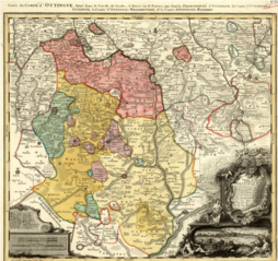
Map showing the territories of the House of
Oettingen in the mid-18th century: the Principality of Oettingen (or Oettingen-Spielberg, in pink) and the Counties of Oettingen-Oettingen (light yellow), Oettingen-Baldern (aqua) and Oettingen-Wallerstein (yellow). Also shown (in purple) are the
258:
164:
The map, which contains information in Latin, French and German, was designed by M. F. Cnopf and published by Homann Erben (Homann Heirs) in 1744.
69:
65:
61:
57:
53:
47:
268:
This file has been identified as being free of known restrictions under copyright law, including all related and neighboring rights.
114:
82:
241:
463:
This file contains additional information, probably added from the digital camera or scanner used to create or digitize it.
466:
If the file has been modified from its original state, some details may not fully reflect the modified file.
395:
410:
358:
The following pages on the
English Knowledge use this file (pages on other projects are not listed):
450:
122:
430:
330:
325:
73:
42:
267:
8:
362:
109:
236:
341:
367:
158:
territories of the free imperial cities of Nördlingen (with its half-dozen
400:
385:
261:
to indicate why this work is in the public domain in the United States.
298:
Click on a date/time to view the file as it appeared at that time.
420:
440:
405:
240:
in its country of origin and other countries and areas where the
411:
Benutzer:Ditschie-wiki/Johann Aloys I. Oettingen-Spielberg
97:
87:(3,664 × 3,456 pixels, file size: 26.53 MB, MIME type:
356:
376:
296:
121:
Commons is a freely licensed media file repository.
173:
396:Oettingen (fränkisch-schwäbisches Adelsgeschlecht)
276:https://creativecommons.org/publicdomain/mark/1.0/
102:
169:
144:
187:
179:
14:
378:The following other wikis use this file:
282:Creative Commons Public Domain Mark 1.0
227:
133:
222:
348:User created page with UploadWizard
13:
461:
151:
134:
80:
495:
468:
357:
251:
226:
101:
31:
21:
259:United States public domain tag
152:
373:
293:
26:
1:
162:), Bopfingen and Dinkelsbühl.
36:
353:
246:life plus 100 years or fewer
198:
7:
458:
417:Usage on de.wikisource.org
147:Oettingen Counties 1744.png
10:
500:
447:Usage on ru.wikipedia.org
437:Usage on nl.wikipedia.org
427:Usage on he.wikipedia.org
392:Usage on de.wikipedia.org
382:Usage on cs.wikipedia.org
191:M. F. Cnopf - Homann Heirs
141:
136:
266:
225:
16:
401:Ochsenberg (Königsbronn)
386:Oettingen-Wallersteinové
257:You must also include a
108:This is a file from the
41:
347:
172:
112:. Information from its
115:description page there
46:Size of this preview:
472:Horizontal resolution
183:Moll's map collection
441:Graafschap Oettingen
421:Grafschaft Oettingen
406:Grafschaft Oettingen
234:This work is in the
74:3,664 × 3,456 pixels
70:2,171 × 2,048 pixels
66:1,086 × 1,024 pixels
480:Vertical resolution
363:County of Oettingen
52:Other resolutions:
326:23:39, 2 July 2018
487:
486:
374:Global file usage
351:
273:
272:
262:
221:
220:
195:
194:
130:
129:
110:Wikimedia Commons
32:Global file usage
491:
469:
338:
300:
289:
286:
283:
280:
277:
256:
255:
254:
244:is the author's
230:
229:
223:
217:
214:
211:
208:
203:
202:
175:
156:
148:
142:
126:
105:
104:
98:
92:
90:
77:
62:814 × 768 pixels
58:509 × 480 pixels
54:254 × 240 pixels
48:636 × 600 pixels
499:
498:
494:
493:
492:
490:
489:
488:
457:
372:
359:
352:
344:
336:
292:
291:
287:
284:
281:
278:
275:
252:
215:
212:
209:
206:
201:
196:
165:
146:
139:
132:
131:
120:
119:
118:is shown below.
94:
88:
86:
79:
78:
51:
12:
11:
5:
497:
485:
484:
481:
477:
476:
473:
460:
456:
455:
454:
453:
445:
444:
443:
435:
434:
433:
425:
424:
423:
415:
414:
413:
408:
403:
398:
390:
389:
388:
375:
371:
370:
365:
355:
350:
349:
346:
342:
339:
335:3,664 × 3,456
333:
328:
323:
319:
318:
315:
312:
309:
306:
303:
295:
271:
270:
264:
263:
242:copyright term
231:
219:
218:
200:
197:
193:
192:
189:
185:
184:
181:
177:
176:
171:
167:
166:
149:
140:
138:
135:
128:
127:
106:
96:
95:
45:
40:
39:
34:
29:
24:
19:
9:
6:
4:
3:
2:
496:
482:
479:
478:
474:
471:
470:
467:
464:
452:
449:
448:
446:
442:
439:
438:
436:
432:
429:
428:
426:
422:
419:
418:
416:
412:
409:
407:
404:
402:
399:
397:
394:
393:
391:
387:
384:
383:
381:
380:
379:
369:
366:
364:
361:
360:
345:
340:
334:
332:
329:
327:
324:
321:
320:
316:
313:
310:
307:
304:
302:
301:
299:
290:
269:
265:
260:
250:
249:
247:
243:
239:
238:
237:public domain
232:
224:
210:Public domain
207:Public domain
205:
204:
190:
186:
182:
178:
168:
163:
161:
155:
150:
143:
124:
117:
116:
111:
107:
100:
99:
93:
84:
83:Original file
75:
71:
67:
63:
59:
55:
49:
44:
38:
35:
33:
30:
28:
25:
23:
20:
18:
15:
465:
462:
377:
297:
294:File history
274:
245:
235:
233:
159:
153:
123:You can help
113:
81:
22:File history
145:Description
368:Nördlingen
354:File usage
337:(26.53 MB)
311:Dimensions
27:File usage
483:47.24 dpc
475:47.24 dpc
451:Эттингены
343:Lubiesque
308:Thumbnail
305:Date/Time
199:Licensing
154:English:
89:image/png
459:Metadata
431:נרדלינגן
160:exclaves
37:Metadata
322:current
317:Comment
137:Summary
85:
188:Author
180:Source
288:false
285:false
216:false
213:false
314:User
174:1744
170:Date
17:File
279:PDM
248:.
72:|
68:|
64:|
60:|
56:|
50:.
125:.
91:)
76:.
Text is available under the Creative Commons Attribution-ShareAlike License. Additional terms may apply.
