33:
378:
432:"}},"text\/plain":{"en":{"":"inception"}}},"{\"value\":{\"time\":\"+1970-01-01T00:00:00Z\",\"timezone\":0,\"before\":0,\"after\":0,\"precision\":11,\"calendarmodel\":\"http:\\\/\\\/www.wikidata.org\\\/entity\\\/Q1985727\"},\"type\":\"time\"}":{"text\/html":{"en":{"P571":"1 January 1970"}},"text\/plain":{"en":{"P571":"1 January 1970"}}}}": -->
168:
268:
89:
508:
428:
51:
47:
43:
37:
100:
68:
429:
276:
507:
502:
59:
32:
439:
418:
212:
This tag does not indicate the copyright status of the attached work. A normal copyright tag is still required. See
194:
202:
368:
535:
The following pages on the
English Knowledge use this file (pages on other projects are not listed):
184:
108:
311:
8:
213:
95:
408:
307:
176:
363:
359:
286:
539:
351:
355:
347:
343:
339:
335:
331:
327:
323:
319:
518:
449:
280:. Like almost all works of the U.S. federal government, works from the
189:
475:
Click on a date/time to view the file as it appeared at that time.
298:
152:
83:
133:
National Atlas 1970 - World around the United States.jpg
402:
Add a one-line explanation of what this file represents
533:
73:(1,448 × 1,739 pixels, file size: 832 KB, MIME type:
473:
107:
Commons is a freely licensed media file repository.
88:
274:This map was obtained from an edition of the
148:
130:
227:
158:
14:
223:National Atlas of the United States, 1970
267:
119:
262:
525:User created page with UploadWizard
466:
277:National Atlas of the United States
203:
201:
195:
193:
177:
175:
13:
407:
401:
376:
273:
137:
120:
66:
551:
406:
143:Azimuthal map centered in the USA
534:
392:
266:
166:
87:
21:
389:
138:
470:
388:
26:
1:
204:University of Texas at Austin
530:
414:Items portrayed in this file
238:
7:
10:
556:
174:This image is a copy or a
127:
122:
467:
16:
391:
94:This is a file from the
31:
524:
312:Perry-Castañeda Library
196:Perry–Castañeda Library
165:
151:
98:. Information from its
381:
101:description page there
36:Size of this preview:
380:
290:in the United States.
216:for more information.
60:1,448 × 1,739 pixels
308:Library of Congress
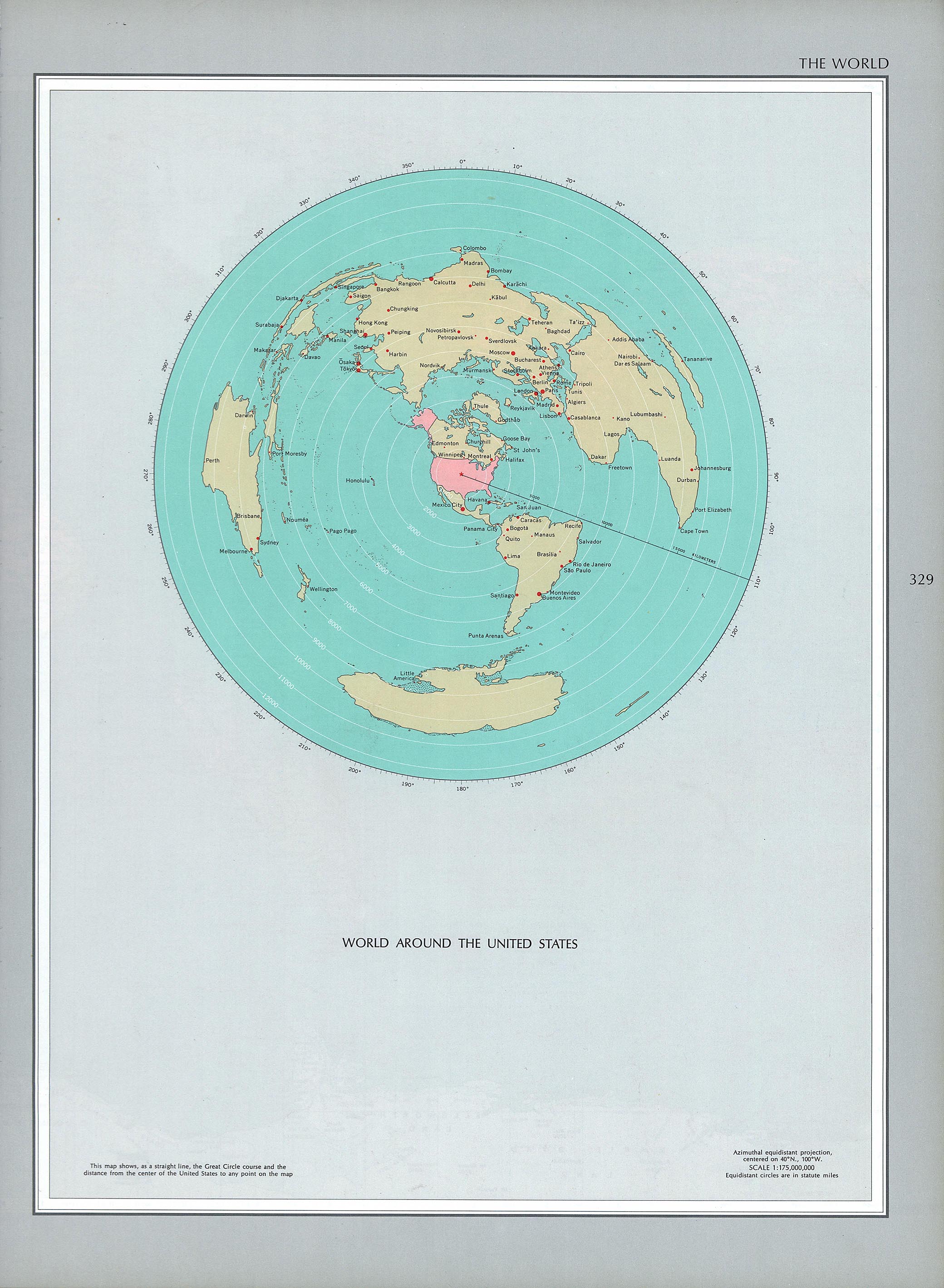
304:1970 print edition:
42:Other resolutions:
503:19:49, 6 June 2018
382:
56:853 × 1,024 pixels
528:
400:
386:
385:
371:
314:
299:NationalAtlas.gov
261:
260:
235:
234:
221:
220:
217:
214:Commons:Licensing
116:
115:
96:Wikimedia Commons
547:
515:
477:
398:
379:
372:
367:
336:Bahasa Indonesia
292:
270:
269:
263:
257:
254:
251:
248:
243:
242:
211:
207:
205:
199:
197:
181:
179:
170:
169:
163:
162:
154:
142:
134:
128:
112:
91:
90:
84:
78:
76:
63:
52:639 × 768 pixels
48:400 × 480 pixels
44:200 × 240 pixels
38:499 × 599 pixels
555:
554:
550:
549:
548:
546:
545:
544:
536:
529:
521:
513:
469:
468:
465:
464:
463:
462:
461:
460:
459:
458:
456:
446:
445:
444:
442:
427:
426:
425:
424:
423:
421:
405:
404:
403:
377:
318:
315:
255:
252:
249:
246:
241:
236:
178:derivative work
167:
144:
132:
125:
118:
117:
106:
105:
104:is shown below.
80:
74:
72:
65:
64:
41:
12:
11:
5:
553:
543:
542:
532:
527:
526:
523:
519:
516:
512:1,448 × 1,739
510:
505:
500:
496:
495:
492:
489:
486:
483:
480:
472:
457:
455:1 January 1970
454:
452:
451:
450:
448:
447:
443:
438:
436:
435:
434:
433:
431:
422:
417:
415:
412:
411:
410:
409:
397:
396:
393:
390:
384:
383:
374:
295:Online access:
282:National Atlas
271:
259:
258:
240:
237:
233:
232:
229:
225:
224:
219:
218:
190:map collection
171:
160:
156:
155:
153:1 January 1970
150:
146:
145:
135:
126:
124:
121:
114:
113:
92:
82:
81:
35:
30:
29:
24:
19:
9:
6:
4:
3:
2:
552:
541:
540:Americentrism
538:
537:
522:
517:
511:
509:
506:
504:
501:
498:
497:
493:
490:
487:
484:
481:
479:
478:
476:
453:
441:
437:
420:
416:
413:
394:
387:
375:
373:
370:
365:
361:
357:
353:
349:
345:
341:
337:
333:
329:
325:
321:
316:
313:
309:
306:
305:
300:
297:
296:
291:
289:
288:
287:public domain
283:
279:
278:
272:
265:
264:
250:Public domain
247:Public domain
245:
244:
230:
226:
222:
215:
210:
208:
206:
200:(PCL) of the
198:
191:
187:
186:
180:
172:
164:
161:
157:
147:
141:
136:
129:
110:
103:
102:
97:
93:
86:
85:
79:
70:
69:Original file
61:
57:
53:
49:
45:
39:
34:
28:
25:
23:
20:
18:
15:
474:
471:File history
317:
303:
302:
294:
293:
285:
281:
275:
185:ca000243.jpg
183:
173:
139:
109:You can help
99:
67:
22:File history
284:are in the
188:, from the
131:Description
531:File usage
488:Dimensions
344:македонски
75:image/jpeg
27:File usage
485:Thumbnail
482:Date/Time
440:inception
430:inception
352:sicilianu
239:Licensing
140:English:
514:(832 KB)
395:Captions
366: |
362: |
358: |
354: |
350: |
346: |
342: |
340:italiano
338: |
334: |
332:français
330: |
326: |
322: |
520:Babelia
499:current
494:Comment
419:depicts
399:English
364:中文(繁體)
360:中文(简体)
328:English
324:Deutsch
320:čeština
192:of the
123:Summary
71:
348:മലയാളം
228:Author
159:Source
256:false
253:false
491:User
231:USGS
149:Date
17:File
369:+/−
182:of
356:中文
310:,
301:|
209:.
58:|
54:|
50:|
46:|
40:.
111:.
77:)
62:.
Text is available under the Creative Commons Attribution-ShareAlike License. Additional terms may apply.
