671:"}},"text\/plain":{"en":{"":"checksum"}}},"{\"value\":\"ad6f7cdce37e635165bc3812337dffaa3a21ffda\",\"type\":\"string\"}":{"text\/html":{"en":{"P4092":"ad6f7cdce37e635165bc3812337dffaa3a21ffda"}},"text\/plain":{"en":{"P4092":"ad6f7cdce37e635165bc3812337dffaa3a21ffda"}}},"{\"value\":{\"entity-type\":\"property\",\"numeric-id\":459,\"id\":\"P459\"},\"type\":\"wikibase-entityid\"}":{"text\/html":{"en":{"":"
873:"}},"text\/plain":{"en":{"":"coordinates of the point of view"}}},"{\"value\":{\"latitude\":-17.533292,\"longitude\":-149.905357,\"altitude\":null,\"precision\":1.0e-6,\"globe\":\"http:\\\/\\\/www.wikidata.org\\\/entity\\\/Q2\"},\"type\":\"globecoordinate\"}":{"text\/html":{"en":{"P1259":"17\u00b031'59.851"S, 149\u00b054'19.285"W"}},"text\/plain":{"en":{"P1259":"17\u00b031'59.851\"S, 149\u00b054'19.285\"W"}}}}": -->
612:"}},"text\/plain":{"en":{"":"start time"}}},"{\"value\":{\"time\":\"+2022-09-05T00:00:00Z\",\"timezone\":0,\"before\":0,\"after\":0,\"precision\":11,\"calendarmodel\":\"http:\\\/\\\/www.wikidata.org\\\/entity\\\/Q1985727\"},\"type\":\"time\"}":{"text\/html":{"en":{"P580":"5 September 2022"}},"text\/plain":{"en":{"P580":"5 September 2022"}}}}": -->
528:"}},"text\/plain":{"en":{"":"inception"}}},"{\"value\":{\"time\":\"+2021-06-21T00:00:00Z\",\"timezone\":0,\"before\":0,\"after\":0,\"precision\":11,\"calendarmodel\":\"http:\\\/\\\/www.wikidata.org\\\/entity\\\/Q1985727\"},\"type\":\"time\"}":{"text\/html":{"en":{"P571":"21 June 2021"}},"text\/plain":{"en":{"P571":"21 June 2021"}}}}": -->
222:
253:
200:
667:
267:
288:
1100:
43:
1208:
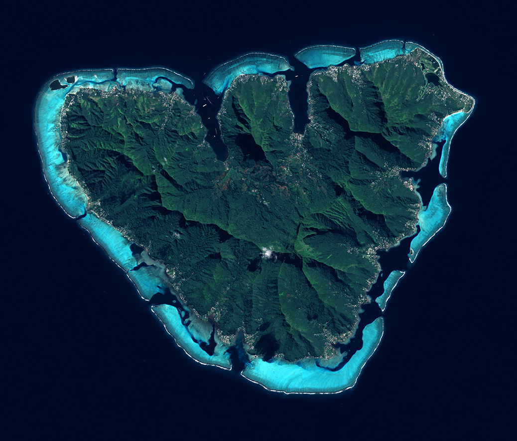
d’observation et de surveillance de la Terre, Copernicus, conduit par l'Union
Europeenne.
Grace aux 2 satellites Sentinel-2A (2015) et Sentinel-2B (2017), tous les 5 jours, la mission Sentinel-2 fournit des cliches de notre planete. Objectifs : suivre a haute resolution l'evolution de la vegetation, de l'occupation des sols et l'impact du rechauffement climatique avec une haute frequence d’observations.
95:
604:"}},"text\/plain":{"en":{"":"Commons quality assessment"}}},"{\"value\":{\"entity-type\":\"item\",\"numeric-id\":63348040,\"id\":\"Q63348040\"},\"type\":\"wikibase-entityid\"}":{"text\/html":{"en":{"P6731":"
608:"}},"text\/plain":{"en":{"P6731":"Wikimedia Commons valued image"}}},"{\"value\":{\"entity-type\":\"property\",\"numeric-id\":580,\"id\":\"P580\"},\"type\":\"wikibase-entityid\"}":{"text\/html":{"en":{"":"
675:"}},"text\/plain":{"en":{"":"determination method"}}},"{\"value\":{\"entity-type\":\"item\",\"numeric-id\":13414952,\"id\":\"Q13414952\"},\"type\":\"wikibase-entityid\"}":{"text\/html":{"en":{"P459":"
566:"}},"text\/plain":{"en":{"":"media type"}}},"{\"value\":\"image\\\/jpeg\",\"type\":\"string\"}":{"text\/html":{"en":{"P1163":"image\/jpeg"}},"text\/plain":{"en":{"P1163":"image\/jpeg"}}}}": -->
738:"}},"text\/plain":{"en":{"":"data size"}}},"{\"value\":{\"amount\":\"+778001\",\"unit\":\"http:\\\/\\\/www.wikidata.org\\\/entity\\\/Q8799\"},\"type\":\"quantity\"}":{"text\/html":{"en":{"P3575":"778,001
828:"}},"text\/plain":{"en":{"":"width"}}},"{\"value\":{\"amount\":\"+1038\",\"unit\":\"http:\\\/\\\/www.wikidata.org\\\/entity\\\/Q355198\"},\"type\":\"quantity\"}":{"text\/html":{"en":{"P2049":"1,038
783:"}},"text\/plain":{"en":{"":"height"}}},"{\"value\":{\"amount\":\"+885\",\"unit\":\"http:\\\/\\\/www.wikidata.org\\\/entity\\\/Q355198\"},\"type\":\"quantity\"}":{"text\/html":{"en":{"P2048":"885
481:"}},"text\/plain":{"en":{"":"depicts"}}},"{\"value\":{\"entity-type\":\"item\",\"numeric-id\":673400,\"id\":\"Q673400\"},\"type\":\"wikibase-entityid\"}":{"text\/html":{"en":{"P180":"
869:
156:
Grace aux 2 satellites
Sentinel-2A (2015) et Sentinel-2B (2017), tous les 5 jours, la mission Sentinel-2 fournit des cliches de notre planete. Objectifs : suivre a haute resolution l'evolution de la vegetation, de l'occupation des sols et l'impact du rechauffement climatique avec une haute
1207:
L'ile de Moorea vue par le satellite
Sentinel 2, le 21 juin 2021.
Moorea est une ile du Pacifique Sud situee dans l'archipel de la Societe en Polynesie francaise. Elle est connue pour ses sommets volcaniques abrupts et ses plages de sable.
La mission Sentinel-2 fait partie du programme
250:
446:
244:
676:
605:
151:
Moorea est une ile du
Pacifique Sud situee dans l'archipel de la Societe en Polynesie francaise. Elle est connue pour ses sommets volcaniques abrupts et ses plages de sable.
393:
GMES dedicated data and GMES service information are provided to users without any express or implied warranty, including as regards quality and suitability for any purpose.
482:
870:
825:
780:
735:
668:
601:
563:
672:
609:
525:
478:
61:
57:
53:
47:
74:
106:
378:
When distributing or communicating GMES dedicated data to the public, users shall inform the public of the source of that data and information.
213:
966:
154:
La mission
Sentinel-2 fait partie du programme d’observation et de surveillance de la Terre, Copernicus, conduit par l'Union Europeenne.
381:
Users shall make sure not to convey the impression to the public that the user’s activities are officially endorsed by the Union.
720:
635:
260:
440:
1163:
This file contains additional information, probably added from the digital camera or scanner used to create or digitize it.
511:
880:
839:
794:
749:
686:
619:
573:
713:
648:
535:
495:
1306:
430:
221:
347:
Access to GMES dedicated data shall be given for the purpose of the following use in so far as it is lawful:
1015:
948:
943:
65:
42:
1166:
If the file has been modified from its original state, some details may not fully reflect the modified file.
339:
Free access shall be given to GMES dedicated data made available through GMES dissemination platforms .
742:"}},"text\/plain":{"en":{"P3575":"778,001 byte"}}}}": -->
327:
323:
832:"}},"text\/plain":{"en":{"P2049":"1,038 pixel"}}}}": -->
983:
The following pages on the
English Knowledge use this file (pages on other projects are not listed):
787:"}},"text\/plain":{"en":{"P2048":"885 pixel"}}}}": -->
114:
485:"}},"text\/plain":{"en":{"P180":"Moorea"}}}}": -->
421:
384:
Where that data or information has been adapted or modified, the user shall clearly state this.
1110:
679:"}},"text\/plain":{"en":{"P459":"SHA-1"}}}}": -->
294:
8:
266:
1101:משתמש:WikiJunkie/רשימות שימושיות שמופקות באמצעות הבוט ליסטריה/איים - כל הערכים שחסרים
101:
970:
1140:
176:
1120:
1005:
959:
890:
849:
804:
759:
696:
629:
583:
545:
505:
1321:
361:
adaptation, modification and combination with other data and information;
306:
302:
298:
199:
369:
GMES dedicated data may be used worldwide without limitations in time.
987:
1130:
916:
Click on a date/time to view the file as it appeared at that time.
149:
L'ile de Moorea vue par le satellite
Sentinel 2, le 21 juin 2021.
245:
17° 31′ 59.85″ S, 149° 54′ 19.29″ W
252:
322:
The use of
Copernicus Sentinel Data is regulated under EU law (
1060:
166:
89:
1055:
471:
Add a one-line explanation of what this file represents
981:
373:
Conditions regarding information to be given by users
1150:
1090:
1045:
996:
914:
282:
113:
Commons is a freely licensed media file repository.
1080:
1070:
1035:
1025:
79:(1,038 × 885 pixels, file size: 760 KB, MIME type:
969:cropped 79 % horizontally, 77 % vertically using
324:Commission Delegated Regulation (EU) No 1159/2013
309:. Attribution is required when using this image.
293:This image contains data from a satellite in the
314:Contains modified Copernicus Sentinel data 2021
94:
967:File:Moorea et Tahiti vues par Sentinel 2.jpg
162:
136:
190:
182:
177:https://phototheque.cnes.fr/cnes/media/69129
172:
14:
1183:L'ile de Moorea par le satellite Sentinel 2
829:
784:
739:
998:The following other wikis use this file:
443:island, French Polynesia - satellite view
702:ad6f7cdce37e635165bc3812337dffaa3a21ffda
214:Moorea et Tahiti vues par Sentinel 2.jpg
428:This image has been assessed under the
139:Moorea vue par Sentinel 2 (cropped).jpg
259:View this and other nearby images on:
364:any combination of points (a) to (d).
125:
408:
235:
907:
13:
1161:
476:
470:
205:
143:
126:
72:
1346:
1199:© Copernicus Sentinel Data/, 2021
1168:
475:
1191:© Copernicus Sentinel Data/, 202
1172:Date and time of data generation
982:
881:coordinates of the point of view
871:coordinates of the point of view
461:
436:the most valued image on Commons
412:
286:
265:
251:
220:
198:
93:
31:
21:
1307:Adobe Photoshop CS5.1 Macintosh
896:17°31'59.851"S, 149°54'19.285"W
458:
413:
144:
1127:Usage on simple.wikipedia.org
993:
911:
636:Wikimedia Commons valued image
606:Wikimedia Commons valued image
457:
26:
1:
445:. You can see its nomination
36:
978:
491:Items portrayed in this file
358:communication to the public;
278:
186:European Space Agency / CNES
7:
1158:
1107:Usage on he.wikivoyage.org
1087:Usage on fr.wikivoyage.org
1052:Usage on en.wikivoyage.org
1042:Usage on de.wikivoyage.org
1012:Usage on arz.wikipedia.org
328:Regulation (EU) No 377/2014
10:
1351:
1147:Usage on www.wikidata.org
1137:Usage on ur.wikipedia.org
1117:Usage on ru.wikipedia.org
1097:Usage on he.wikipedia.org
1077:Usage on fr.wikipedia.org
1067:Usage on eu.wikipedia.org
1032:Usage on cy.wikipedia.org
1022:Usage on ca.wikipedia.org
1002:Usage on ar.wikipedia.org
620:Commons quality assessment
602:Commons quality assessment
194:
133:
128:
1313:File change date and time
908:
287:
157:frequence d’observations.
16:
460:
343:Conditions regarding use
100:This is a file from the
41:
965:
271:-17.533292; -149.905357
165:
104:. Information from its
1316:16:00, 2 February 2022
330:). Relevant excerpts:
107:description page there
46:Size of this preview:
1279:Horizontal resolution
431:valued image criteria
1271:Number of components
714:determination method
673:determination method
335:Financial conditions
295:Copernicus Programme
1287:Vertical resolution
1175:00:00, 21 June 2021
973:with lossless mode.
389:Absence of warranty
206:This file has been
52:Other resolutions:
1247:Compression scheme
1229:Bits per component
1131:User:0x16w/Partula
944:14:08, 26 May 2022
438:within the scope:
434:and is considered
66:1,038 × 885 pixels
1338:
1337:
1255:Pixel composition
994:Global file usage
976:
831:
786:
741:
469:
455:
454:
400:
399:
276:
275:
233:
232:
229:
228:
210:from another file
122:
121:
102:Wikimedia Commons
32:Global file usage
1342:
1295:Data arrangement
1196:Copyright holder
1169:
956:
918:
858:
813:
768:
723:
718:
656:
655:5 September 2022
653:
467:
416:
415:
409:
404:
319:
315:
290:
289:
283:
272:
269:
255:
254:
248:
247:
236:
224:
202:
195:
168:
148:
140:
134:
118:
97:
96:
90:
84:
82:
69:
62:901 × 768 pixels
58:563 × 480 pixels
54:282 × 240 pixels
48:703 × 599 pixels
1350:
1349:
1345:
1344:
1343:
1341:
1340:
1339:
1188:Credit/Provider
1157:
1061:Society Islands
992:
984:
977:
962:
954:
910:
909:
906:
905:
904:
903:
902:
901:
900:
899:
897:
887:
886:
885:
883:
868:
867:
866:
865:
864:
863:
862:
861:
859:
856:
846:
845:
844:
842:
823:
822:
821:
820:
819:
818:
817:
816:
814:
811:
801:
800:
799:
797:
778:
777:
776:
775:
774:
773:
772:
771:
769:
766:
756:
755:
754:
752:
733:
732:
731:
730:
729:
728:
727:
726:
725:
724:
719:
716:
707:
706:
705:
703:
693:
692:
691:
689:
666:
665:
664:
663:
662:
661:
660:
659:
658:
657:
654:
651:
642:
641:
640:
638:
626:
625:
624:
622:
599:
598:
597:
596:
595:
594:
593:
592:
590:
580:
579:
578:
576:
561:
560:
559:
558:
557:
556:
555:
554:
552:
542:
541:
540:
538:
523:
522:
521:
520:
519:
518:
517:
516:
514:
502:
501:
500:
498:
474:
473:
472:
451:
425:
402:
367:
320:
317:
313:
281:
270:
243:
242:
239:Camera location
234:
225:
211:
158:
138:
131:
124:
123:
112:
111:
110:is shown below.
86:
80:
78:
71:
70:
51:
12:
11:
5:
1348:
1336:
1335:
1332:
1328:
1327:
1324:
1318:
1317:
1314:
1310:
1309:
1304:
1300:
1299:
1296:
1292:
1291:
1288:
1284:
1283:
1280:
1276:
1275:
1272:
1268:
1267:
1264:
1260:
1259:
1256:
1252:
1251:
1248:
1244:
1243:
1242:
1241:
1238:
1235:
1230:
1226:
1225:
1222:
1218:
1217:
1214:
1210:
1209:
1205:
1201:
1200:
1197:
1193:
1192:
1189:
1185:
1184:
1181:
1177:
1176:
1173:
1160:
1156:
1155:
1154:
1153:
1145:
1144:
1143:
1135:
1134:
1133:
1125:
1124:
1123:
1115:
1114:
1113:
1105:
1104:
1103:
1095:
1094:
1093:
1085:
1084:
1083:
1075:
1074:
1073:
1065:
1064:
1063:
1058:
1050:
1049:
1048:
1040:
1039:
1038:
1030:
1029:
1028:
1020:
1019:
1018:
1010:
1009:
1008:
995:
991:
990:
980:
975:
974:
964:
960:
957:
951:
946:
941:
937:
936:
933:
930:
927:
924:
921:
913:
898:
895:
893:
892:
891:
889:
888:
884:
879:
877:
876:
875:
874:
872:
860:
854:
852:
851:
850:
848:
847:
843:
838:
836:
835:
834:
833:
827:
815:
809:
807:
806:
805:
803:
802:
798:
793:
791:
790:
789:
788:
782:
770:
764:
762:
761:
760:
758:
757:
753:
748:
746:
745:
744:
743:
737:
712:
711:
710:
709:
708:
704:
701:
699:
698:
697:
695:
694:
690:
685:
683:
682:
681:
680:
678:
674:
670:
647:
646:
645:
644:
643:
639:
634:
632:
631:
630:
628:
627:
623:
618:
616:
615:
614:
613:
611:
607:
603:
591:
588:
586:
585:
584:
582:
581:
577:
572:
570:
569:
568:
567:
565:
553:
550:
548:
547:
546:
544:
543:
539:
534:
532:
531:
530:
529:
527:
515:
510:
508:
507:
506:
504:
503:
499:
494:
492:
489:
488:
487:
486:
484:
480:
466:
465:
462:
459:
453:
452:
426:
419:
417:
398:
397:
395:
391:
390:
386:
385:
382:
379:
375:
374:
366:
365:
362:
359:
356:
353:
349:
345:
344:
337:
336:
310:
291:
280:
277:
274:
273:
263:
257:
240:
231:
230:
227:
226:
219:
217:
203:
192:
191:Other versions
188:
187:
184:
180:
179:
174:
170:
169:
164:
160:
159:
141:
132:
130:
127:
120:
119:
98:
88:
87:
45:
40:
39:
34:
29:
24:
19:
9:
6:
4:
3:
2:
1347:
1333:
1330:
1329:
1325:
1323:
1320:
1319:
1315:
1312:
1311:
1308:
1305:
1303:Software used
1302:
1301:
1298:chunky format
1297:
1294:
1293:
1289:
1286:
1285:
1281:
1278:
1277:
1273:
1270:
1269:
1265:
1262:
1261:
1257:
1254:
1253:
1249:
1246:
1245:
1239:
1236:
1233:
1232:
1231:
1228:
1227:
1223:
1220:
1219:
1215:
1212:
1211:
1206:
1203:
1202:
1198:
1195:
1194:
1190:
1187:
1186:
1182:
1179:
1178:
1174:
1171:
1170:
1167:
1164:
1152:
1149:
1148:
1146:
1142:
1139:
1138:
1136:
1132:
1129:
1128:
1126:
1122:
1119:
1118:
1116:
1112:
1109:
1108:
1106:
1102:
1099:
1098:
1096:
1092:
1089:
1088:
1086:
1082:
1079:
1078:
1076:
1072:
1069:
1068:
1066:
1062:
1059:
1057:
1054:
1053:
1051:
1047:
1044:
1043:
1041:
1037:
1034:
1033:
1031:
1027:
1024:
1023:
1021:
1017:
1016:موريا (جزيره)
1014:
1013:
1011:
1007:
1004:
1003:
1001:
1000:
999:
989:
986:
985:
972:
968:
963:
958:
952:
950:
947:
945:
942:
939:
938:
934:
931:
928:
925:
922:
920:
919:
917:
894:
882:
878:
853:
841:
837:
808:
796:
792:
763:
751:
747:
722:
715:
700:
688:
684:
650:
637:
633:
621:
617:
587:
575:
571:
549:
537:
533:
513:
509:
497:
493:
490:
463:
456:
450:
448:
444:
442:
437:
433:
432:
424:
423:
418:
411:
410:
407:
405:
396:
394:
388:
387:
383:
380:
377:
376:
372:
371:
370:
363:
360:
357:
355:distribution;
354:
352:reproduction;
351:
350:
348:
342:
341:
340:
334:
333:
332:
331:
329:
325:
316:
312:Attribution:
308:
304:
300:
296:
292:
285:
284:
268:
264:
262:
261:OpenStreetMap
258:
256:
246:
241:
238:
237:
223:
218:
216:
215:
209:
204:
201:
197:
196:
193:
189:
185:
181:
178:
175:
171:
161:
155:
152:
147:
142:
135:
116:
109:
108:
103:
99:
92:
91:
85:
76:
75:Original file
67:
63:
59:
55:
49:
44:
38:
35:
33:
30:
28:
25:
23:
20:
18:
15:
1326:Uncalibrated
1250:Uncompressed
1165:
1162:
997:
953:1,038 × 885
915:
912:File history
551:21 June 2021
439:
435:
429:
427:
422:Valued image
420:
406:
401:
392:
368:
346:
338:
321:
311:
207:
167:21 June 2021
153:
150:
145:
115:You can help
105:
73:
22:File history
1331:IIM version
1322:Color space
1263:Orientation
1204:Image title
403:Attribution
318:Attribution
137:Description
979:File usage
929:Dimensions
649:start time
610:start time
589:image/jpeg
574:media type
564:media type
307:Sentinel-3
303:Sentinel-2
299:Sentinel-1
297:, such as
81:image/jpeg
27:File usage
1216:12,520 px
1056:Polynesia
926:Thumbnail
923:Date/Time
750:data size
736:data size
536:inception
526:inception
279:Licensing
208:extracted
146:English:
1224:9,449 px
1180:Headline
1159:Metadata
1111:פולינזיה
971:CropTool
955:(760 KB)
765:778,001
687:checksum
669:checksum
464:Captions
37:Metadata
1290:300 dpi
1282:300 dpi
1151:Q673400
988:Moʻorea
961:Don-vip
940:current
935:Comment
496:depicts
479:depicts
468:English
129:Summary
77:
1266:Normal
1221:Height
1141:مووریا
1091:Moorea
1081:Moorea
1071:Moorea
1046:Moorea
1036:Moorea
1026:Moorea
855:1,038
795:height
781:height
512:Moorea
483:Moorea
441:Moorea
249:
183:Author
173:Source
1213:Width
1121:Муреа
1006:موريا
857:pixel
840:width
830:pixel
826:width
812:pixel
785:pixel
721:SHA-1
677:SHA-1
932:User
810:885
767:byte
740:byte
447:here
326:and
163:Date
17:File
1258:RGB
305:or
717::
652::
449:.
301:,
212::
64:|
60:|
56:|
50:.
1334:2
1274:3
1240:8
1237:8
1234:8
117:.
83:)
68:.
Text is available under the Creative Commons Attribution-ShareAlike License. Additional terms may apply.
.jpg)

.jpg¶ms=-17.533292_N_-149.905357_E_globe:Earth_type:camera__&language=en)