1061:"}},"text\/plain":{"en":{"":"coordinates of the point of view"}}},"{\"value\":{\"latitude\":52.56180625814552,\"longitude\":-3.1514770028147505,\"altitude\":null,\"precision\":0.0001,\"globe\":\"http:\\\/\\\/www.wikidata.org\\\/entity\\\/Q2\"},\"type\":\"globecoordinate\"}":{"text\/html":{"en":{"P1259":"52\u00b033'42.5"N, 3\u00b09'5.4"W"}},"text\/plain":{"en":{"P1259":"52\u00b033'42.5\"N, 3\u00b09'5.4\"W"}}},"{\"value\":{\"entity-type\":\"property\",\"numeric-id\":7787,\"id\":\"P7787\"},\"type\":\"wikibase-entityid\"}":{"text\/html":{"en":{"":"
1129:"}},"text\/plain":{"en":{"":"coordinates of depicted place"}}},"{\"value\":{\"latitude\":52.56361279407358,\"longitude\":-3.1503442652537768,\"altitude\":null,\"precision\":0.0001,\"globe\":\"http:\\\/\\\/www.wikidata.org\\\/entity\\\/Q2\"},\"type\":\"globecoordinate\"}":{"text\/html":{"en":{"P9149":"52\u00b033'49.0"N, 3\u00b09'1.1"W"}},"text\/plain":{"en":{"P9149":"52\u00b033'49.0\"N, 3\u00b09'1.1\"W"}}}}": -->
772:"}},"text\/plain":{"en":{"":"author name string"}}},"{\"value\":\"nick macneill\",\"type\":\"string\"}":{"text\/html":{"en":{"P2093":"nick macneill"}},"text\/plain":{"en":{"P2093":"nick macneill"}}},"{\"value\":{\"entity-type\":\"property\",\"numeric-id\":1476,\"id\":\"P1476\"},\"type\":\"wikibase-entityid\"}":{"text\/html":{"en":{"":"
625:"}},"text\/plain":{"en":{"":"author name string"}}},"{\"value\":\"nick macneill\",\"type\":\"string\"}":{"text\/html":{"en":{"P2093":"nick macneill"}},"text\/plain":{"en":{"P2093":"nick macneill"}}},"{\"value\":{\"entity-type\":\"property\",\"numeric-id\":2699,\"id\":\"P2699\"},\"type\":\"wikibase-entityid\"}":{"text\/html":{"en":{"":"
33:
408:
342:
286:
234:
213:
197:
181:
165:
148:
1023:"}},"text\/plain":{"en":{"":"inception"}}},"{\"value\":{\"time\":\"+2010-06-03T00:00:00Z\",\"timezone\":0,\"before\":0,\"after\":0,\"precision\":11,\"calendarmodel\":\"http:\\\/\\\/www.wikidata.org\\\/entity\\\/Q1985727\"},\"type\":\"time\"}":{"text\/html":{"en":{"P571":"3 June 2010"}},"text\/plain":{"en":{"P571":"3 June 2010"}}}}": -->
900:
349:
301:
760:
363:
315:
386:
432:
437:
89:
768:"}},"text\/plain":{"en":{"P275":"Creative Commons Attribution-ShareAlike 2.0 Generic"}}},"{\"value\":{\"entity-type\":\"property\",\"numeric-id\":2093,\"id\":\"P2093\"},\"type\":\"wikibase-entityid\"}":{"text\/html":{"en":{"":"
908:"}},"text\/plain":{"en":{"P7482":"file available on the internet"}}},"{\"value\":{\"entity-type\":\"property\",\"numeric-id\":7384,\"id\":\"P7384\"},\"type\":\"wikibase-entityid\"}":{"text\/html":{"en":{"":"
617:"}},"text\/plain":{"en":{"":"object of statement has role"}}},"{\"value\":{\"entity-type\":\"item\",\"numeric-id\":33231,\"id\":\"Q33231\"},\"type\":\"wikibase-entityid\"}":{"text\/html":{"en":{"P3831":"
924:"}},"text\/plain":{"en":{"P137":"Geograph Britain and Ireland"}}},"{\"value\":{\"entity-type\":\"property\",\"numeric-id\":973,\"id\":\"P973\"},\"type\":\"wikibase-entityid\"}":{"text\/html":{"en":{"":"
1167:"}},"text\/plain":{"en":{"":"location of creation"}}},"{\"value\":{\"entity-type\":\"item\",\"numeric-id\":42949567,\"id\":\"Q42949567\"},\"type\":\"wikibase-entityid\"}":{"text\/html":{"en":{"P1071":"
764:"}},"text\/plain":{"en":{"":"copyright license"}}},"{\"value\":{\"entity-type\":\"item\",\"numeric-id\":19068220,\"id\":\"Q19068220\"},\"type\":\"wikibase-entityid\"}":{"text\/html":{"en":{"P275":"
720:"}},"text\/plain":{"en":{"":"copyright status"}}},"{\"value\":{\"entity-type\":\"item\",\"numeric-id\":50423863,\"id\":\"Q50423863\"},\"type\":\"wikibase-entityid\"}":{"text\/html":{"en":{"P6216":"
904:"}},"text\/plain":{"en":{"":"source of file"}}},"{\"value\":{\"entity-type\":\"item\",\"numeric-id\":74228490,\"id\":\"Q74228490\"},\"type\":\"wikibase-entityid\"}":{"text\/html":{"en":{"P7482":"
549:"}},"text\/plain":{"en":{"P180":"castle"}}},"{\"value\":{\"entity-type\":\"item\",\"numeric-id\":42949567,\"id\":\"Q42949567\"},\"type\":\"wikibase-entityid\"}":{"text\/html":{"en":{"P180":"
621:"}},"text\/plain":{"en":{"P3831":"photographer"}}},"{\"value\":{\"entity-type\":\"property\",\"numeric-id\":2093,\"id\":\"P2093\"},\"type\":\"wikibase-entityid\"}":{"text\/html":{"en":{"":"
920:"}},"text\/plain":{"en":{"":"operator"}}},"{\"value\":{\"entity-type\":\"item\",\"numeric-id\":1503119,\"id\":\"Q1503119\"},\"type\":\"wikibase-entityid\"}":{"text\/html":{"en":{"P137":"
860:"}},"text\/plain":{"en":{"":"instance of"}}},"{\"value\":{\"entity-type\":\"item\",\"numeric-id\":125191,\"id\":\"Q125191\"},\"type\":\"wikibase-entityid\"}":{"text\/html":{"en":{"P31":"
1065:"}},"text\/plain":{"en":{"":"heading"}}},"{\"value\":{\"amount\":\"+22\",\"unit\":\"http:\\\/\\\/www.wikidata.org\\\/entity\\\/Q28390\"},\"type\":\"quantity\"}":{"text\/html":{"en":{"P7787":"22
916:"}},"text\/plain":{"en":{"P7384":"1923084"}}},"{\"value\":{\"entity-type\":\"property\",\"numeric-id\":137,\"id\":\"P137\"},\"type\":\"wikibase-entityid\"}":{"text\/html":{"en":{"":"
545:"}},"text\/plain":{"en":{"":"depicts"}}},"{\"value\":{\"entity-type\":\"item\",\"numeric-id\":23413,\"id\":\"Q23413\"},\"type\":\"wikibase-entityid\"}":{"text\/html":{"en":{"P180":"
613:"}},"text\/plain":{"en":{"":"creator"}}},"{\"value\":{\"entity-type\":\"property\",\"numeric-id\":3831,\"id\":\"P3831\"},\"type\":\"wikibase-entityid\"}":{"text\/html":{"en":{"":"
1249:
1163:
278:
487:– You must give appropriate credit, provide a link to the license, and indicate if changes were made. You may do so in any reasonable manner, but not in any way that suggests the licensor endorses you or your use.
346:
298:
55:
51:
47:
43:
37:
913:
1168:
905:
765:
721:
550:
100:
921:
68:
861:
618:
546:
1164:
1126:
1062:
1058:
909:
901:
773:
769:
717:
626:
622:
614:
929:
630:
1020:
925:
917:
761:
610:
542:
857:
147:
341:
285:
233:
196:
1259:
407:
212:
180:
164:
633:"}},"text\/plain":{"en":{"P2699":"https:\/\/www.geograph.org.uk\/profile\/37997"}}}}": -->
932:"}},"text\/plain":{"en":{"P973":"https:\/\/www.geograph.org.uk\/photo\/1923084"}}}}": -->
1194:
955:
806:
747:
596:
356:
308:
990:
393:
887:
494:
674:
579:
1178:
1136:
1103:
1076:
968:
939:
832:
819:
731:
695:
682:
667:
1030:
998:
983:
790:
640:
563:
871:
1248:
1243:
59:
32:
1290:
447:
783:"}},"text\/plain":{"en":{"P1476":"Montgomery Castle"}}}}": -->
493:– If you remix, transform, or build upon the material, you must distribute your contributions under the
400:
on the
Geograph website for the photographer's contact details. The copyright on this image is owned by
724:"}},"text\/plain":{"en":{"P6216":"copyrighted"}}}}": -->
1276:
The following pages on the
English Knowledge use this file (pages on other projects are not listed):
1171:"}},"text\/plain":{"en":{"P1071":"Montgomery"}}}}": -->
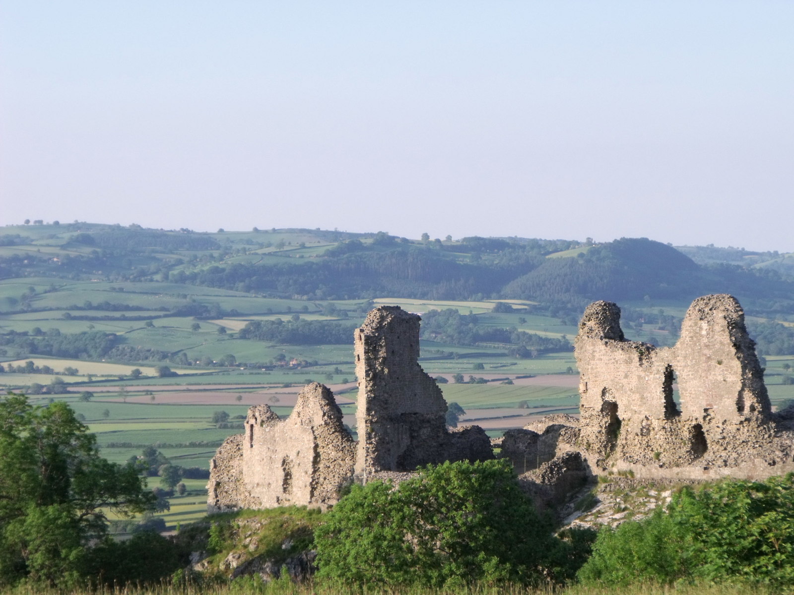
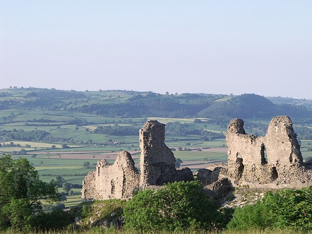
1069:"}},"text\/plain":{"en":{"P7787":"22 degree"}}}}": -->
553:"}},"text\/plain":{"en":{"P180":"Montgomery"}}}}": -->
864:"}},"text\/plain":{"en":{"P31":"photograph"}}}}": -->
108:
1005:
975:
702:
780:
444:
8:
380:
246:
362:
314:
257:
413:
95:
777:
252:
1266:
Uploading geograph.org.uk image from https://www.geograph.org.uk/photo/1923084
402:
207:
191:
1188:
1146:
1086:
1040:
949:
881:
800:
741:
650:
590:
573:
239:
226:
385:
1285:
397:
251:
245:
1216:
Click on a date/time to view the file as it appeared at that time.
348:
300:
1280:
279:
52° 33′ 42.5″ N, 3° 09′ 05″ W
335:
52° 33′ 49″ N, 3° 09′ 01″ W
175:
83:
1274:
240:
227:
73:(1,600 × 1,200 pixels, file size: 335 KB, MIME type:
1214:
258:
107:
Commons is a freely licensed media file repository.
807:
Creative
Commons Attribution-ShareAlike 2.0 Generic
766:
Creative
Commons Attribution-ShareAlike 2.0 Generic
135:Montgomery Castle - geograph.org.uk - 1923084.jpg
504:https://creativecommons.org/licenses/by-sa/2.0
88:
930:https:\/\/www.geograph.org.uk\/photo\/1923084
631:https:\/\/www.geograph.org.uk\/profile\/37997
510:Creative Commons Attribution-Share Alike 2.0
425:
171:
132:
203:
187:
14:
1066:
470:– to copy, distribute and transmit the work
406:
340:
284:
232:
211:
195:
179:
163:
146:
1006:https://www.geograph.org.uk/photo/1923084
703:https://www.geograph.org.uk/profile/37997
355:View this and other nearby images on:
307:View this and other nearby images on:
119:
412:and is licensed for reuse under the
325:
269:
1207:
448:Attribution-Share Alike 2.0 Generic
436:
431:
416:Attribution-ShareAlike 2.0 license.
13:
540:
534:
422:
391:
139:
120:
66:
1302:
539:
1275:
1077:coordinates of the point of view
1059:coordinates of the point of view
525:
481:Under the following conditions:
443:This file is licensed under the
435:
430:
424:
384:
361:
347:
313:
299:
291:
87:
21:
522:
1291:User:DankJae/templates/sandbox
1211:
956:file available on the internet
906:file available on the internet
521:
392:This image was taken from the
375:
26:
1:
1137:coordinates of depicted place
1127:coordinates of depicted place
1271:
991:Geograph Britain and Ireland
922:Geograph Britain and Ireland
668:object of statement has role
615:object of statement has role
559:Items portrayed in this file
374:
290:
192:Geograph Britain and Ireland
123:
7:
10:
1307:
842:
495:same or compatible license
129:
122:
1208:
839:
16:
969:geograph.org.uk image ID
910:geograph.org.uk image ID
524:
461:
162:castle, Montgomery
94:This is a file from the
31:
1265:
1152:52°33'49.0"N, 3°9'1.1"W
1092:52°33'42.5"N, 3°9'5.4"W
174:
145:Montgomery Castle
98:. Information from its
398:this photograph's page
367:52.563613; -3.150344
319:52.561806; -3.151477
101:description page there
36:Size of this preview:
458:by nick macneill
1244:16:48, 25 April 2021
1179:location of creation
1165:location of creation
60:1,600 × 1,200 pixels
476:– to adapt the work
42:Other resolutions:
820:author name string
770:author name string
683:author name string
623:author name string
56:1,280 × 960 pixels
52:1,024 × 768 pixels
1269:
1068:
840:Montgomery Castle
791:copyright license
782:
779:
778:Montgomery Castle
762:copyright license
535:Montgomery Castle
533:
456:Montgomery Castle
421:
420:
396:collection. See
372:
371:
324:
323:
267:
266:
262:
220:Place of creation
116:
115:
96:Wikimedia Commons
1298:
1256:
1218:
1114:
1113:
1108:
1008:
1003:
999:described at URL
993:
988:
978:
973:
926:described at URL
845:
844:
841:
837:
827:
824:
732:copyright status
718:copyright status
705:
700:
690:
687:
677:
672:
531:
517:
514:
511:
508:
505:
497:as the original.
459:
445:Creative Commons
439:
438:
434:
433:
428:
427:
414:Creative Commons
410:
394:Geograph project
388:
381:
377:
368:
365:
351:
350:
344:
338:
337:
326:
320:
317:
303:
302:
296:
295:
294:
288:
282:
281:
270:
260:
254:
248:
242:
238:
236:
229:
215:
199:
183:
177:
167:
150:
144:
136:
130:
125:
112:
91:
90:
84:
78:
76:
63:
48:640 × 480 pixels
44:320 × 240 pixels
38:800 × 600 pixels
1306:
1305:
1301:
1300:
1299:
1297:
1296:
1295:
1277:
1270:
1262:
1254:
1210:
1209:
1206:
1205:
1204:
1203:
1202:
1201:
1200:
1199:
1197:
1185:
1184:
1183:
1181:
1162:
1161:
1160:
1159:
1158:
1157:
1156:
1155:
1153:
1143:
1142:
1141:
1139:
1124:
1123:
1122:
1121:
1120:
1119:
1118:
1117:
1116:
1115:
1111:
1109:
1106:
1097:
1096:
1095:
1093:
1083:
1082:
1081:
1079:
1056:
1055:
1054:
1053:
1052:
1051:
1050:
1049:
1047:
1037:
1036:
1035:
1033:
1018:
1017:
1016:
1015:
1014:
1013:
1012:
1011:
1010:
1009:
1004:
1001:
995:
994:
989:
986:
980:
979:
974:
971:
962:
961:
960:
958:
946:
945:
944:
942:
899:
898:
897:
896:
895:
894:
893:
892:
890:
878:
877:
876:
874:
855:
854:
853:
852:
851:
850:
849:
848:
847:
846:
838:
835:
829:
828:
825:
822:
813:
812:
811:
809:
797:
796:
795:
793:
759:
758:
757:
756:
755:
754:
753:
752:
750:
738:
737:
736:
734:
715:
714:
713:
712:
711:
710:
709:
708:
707:
706:
701:
698:
692:
691:
688:
685:
679:
678:
673:
670:
661:
660:
659:
657:
647:
646:
645:
643:
608:
607:
606:
605:
604:
603:
602:
601:
599:
588:
587:
586:
585:
584:
582:
570:
569:
568:
566:
538:
537:
536:
519:
518:
515:
512:
509:
506:
503:
502:
460:
454:
451:
440:
417:
379:
366:
333:
332:
329:Object location
318:
292:
277:
276:
273:Camera location
268:
223:
159:
151:
140:
134:
127:
118:
117:
106:
105:
104:is shown below.
80:
74:
72:
65:
64:
41:
12:
11:
5:
1304:
1294:
1293:
1288:
1283:
1273:
1268:
1267:
1264:
1260:
1257:
1253:1,600 × 1,200
1251:
1246:
1241:
1237:
1236:
1233:
1230:
1227:
1224:
1221:
1213:
1198:
1193:
1191:
1190:
1189:
1187:
1186:
1182:
1177:
1175:
1174:
1173:
1172:
1170:
1166:
1154:
1151:
1149:
1148:
1147:
1145:
1144:
1140:
1135:
1133:
1132:
1131:
1130:
1128:
1102:
1101:
1100:
1099:
1098:
1094:
1091:
1089:
1088:
1087:
1085:
1084:
1080:
1075:
1073:
1072:
1071:
1070:
1064:
1060:
1048:
1045:
1043:
1042:
1041:
1039:
1038:
1034:
1029:
1027:
1026:
1025:
1024:
1022:
997:
996:
982:
981:
967:
966:
965:
964:
963:
959:
954:
952:
951:
950:
948:
947:
943:
940:source of file
938:
936:
935:
934:
933:
931:
927:
923:
919:
915:
911:
907:
903:
902:source of file
891:
886:
884:
883:
882:
880:
879:
875:
870:
868:
867:
866:
865:
863:
859:
831:
830:
818:
817:
816:
815:
814:
810:
805:
803:
802:
801:
799:
798:
794:
789:
787:
786:
785:
784:
775:
771:
767:
763:
751:
746:
744:
743:
742:
740:
739:
735:
730:
728:
727:
726:
725:
723:
719:
694:
693:
681:
680:
666:
665:
664:
663:
662:
658:
655:
653:
652:
651:
649:
648:
644:
639:
637:
636:
635:
634:
632:
628:
624:
620:
616:
612:
600:
595:
593:
592:
591:
589:
583:
578:
576:
575:
574:
572:
571:
567:
562:
560:
557:
556:
555:
554:
552:
548:
544:
530:
529:
526:
523:
501:
500:
499:
498:
488:
479:
478:
477:
471:
464:You are free:
452:
442:
441:
423:
419:
418:
389:
378:
373:
370:
369:
359:
353:
330:
322:
321:
311:
305:
274:
265:
264:
259:United Kingdom
224:
221:
217:
216:
205:
201:
200:
189:
185:
184:
173:
169:
168:
160:
157:
153:
152:
137:
128:
126:
121:
114:
113:
92:
82:
81:
35:
30:
29:
24:
19:
9:
6:
4:
3:
2:
1303:
1292:
1289:
1287:
1284:
1282:
1279:
1278:
1263:
1258:
1252:
1250:
1247:
1245:
1242:
1239:
1238:
1234:
1231:
1228:
1225:
1222:
1220:
1219:
1217:
1196:
1192:
1180:
1176:
1150:
1138:
1134:
1105:
1090:
1078:
1074:
1044:
1032:
1028:
1007:
1000:
992:
985:
977:
970:
957:
953:
941:
937:
889:
885:
873:
869:
834:
826:nick macneill
821:
808:
804:
792:
788:
749:
745:
733:
729:
704:
697:
689:nick macneill
684:
676:
669:
654:
642:
638:
598:
594:
581:
577:
565:
561:
558:
527:
520:
507:CC BY-SA 2.0
496:
492:
489:
486:
483:
482:
480:
475:
472:
469:
466:
465:
463:
462:
457:
453:Attribution:
449:
446:
429:
415:
411:
409:
404:
403:nick macneill
399:
395:
390:
387:
383:
382:
364:
360:
358:
357:OpenStreetMap
354:
352:
343:
336:
331:
328:
327:
316:
312:
310:
309:OpenStreetMap
306:
304:
287:
280:
275:
272:
271:
261:
255:
249:
243:
235:
230:
225:
219:
218:
214:
209:
208:nick macneill
206:
202:
198:
193:
190:
186:
182:
170:
166:
161:
155:
154:
149:
143:
138:
131:
110:
103:
102:
97:
93:
86:
85:
79:
70:
69:Original file
61:
57:
53:
49:
45:
39:
34:
28:
25:
23:
20:
18:
15:
1215:
1212:File history
675:photographer
619:photographer
490:
484:
473:
467:
455:
401:
289:
141:
109:You can help
99:
67:
22:File history
1261:GeographBot
1046:3 June 2010
872:instance of
858:instance of
748:copyrighted
722:copyrighted
491:share alike
485:attribution
176:3 June 2010
133:Description
1286:Talk:Powys
1272:File usage
1229:Dimensions
1195:Montgomery
1169:Montgomery
888:photograph
862:photograph
656:some value
597:Montgomery
551:Montgomery
241:Montgomery
228:Montgomery
75:image/jpeg
27:File usage
1226:Thumbnail
1223:Date/Time
1031:inception
1021:inception
843:(English)
781:(English)
376:Licensing
222:InfoField
158:InfoField
1255:(335 KB)
984:operator
918:operator
528:Captions
474:to remix
468:to share
450:license.
142:English:
1240:current
1235:Comment
1104:heading
1063:heading
976:1923084
914:1923084
641:creator
611:creator
564:depicts
543:depicts
532:English
156:Depicts
124:Summary
71:
1112:degree
1067:degree
580:castle
547:castle
405:
345:
339:
297:
283:
231:
210:
204:Author
194:
188:Source
178:
1281:Powys
833:title
774:title
253:Wales
247:Powys
1232:User
516:true
513:true
172:Date
17:File
1110:22
696:URL
627:URL
1107::
1002::
987::
972::
836::
823::
699::
686::
671::
58:|
54:|
50:|
46:|
40:.
263:)
256:→
250:→
244:→
237:(
111:.
77:)
62:.
Text is available under the Creative Commons Attribution-ShareAlike License. Additional terms may apply.