645:"}},"text\/plain":{"en":{"":"inception"}}},"{\"value\":{\"time\":\"+2011-11-15T00:00:00Z\",\"timezone\":0,\"before\":0,\"after\":0,\"precision\":11,\"calendarmodel\":\"http:\\\/\\\/www.wikidata.org\\\/entity\\\/Q1985727\"},\"type\":\"time\"}":{"text\/html":{"en":{"P571":"15 November 2011"}},"text\/plain":{"en":{"P571":"15 November 2011"}}}}": -->
38:
446:
315:
320:
94:
979:
466:"}},"text\/plain":{"en":{"P2699":"https:\/\/commons.wikimedia.org\/wiki\/user:Nilfanion"}}},"{\"value\":{\"entity-type\":\"property\",\"numeric-id\":4174,\"id\":\"P4174\"},\"type\":\"wikibase-entityid\"}":{"text\/html":{"en":{"":"
458:"}},"text\/plain":{"en":{"P2093":"Nilfanion","P4174":"Nilfanion"}}},"{\"value\":{\"entity-type\":\"property\",\"numeric-id\":2699,\"id\":\"P2699\"},\"type\":\"wikibase-entityid\"}":{"text\/html":{"en":{"":"
601:"}},"text\/plain":{"en":{"":"copyright license"}}},"{\"value\":{\"entity-type\":\"item\",\"numeric-id\":14946043,\"id\":\"Q14946043\"},\"type\":\"wikibase-entityid\"}":{"text\/html":{"en":{"P275":"
557:"}},"text\/plain":{"en":{"":"copyright status"}}},"{\"value\":{\"entity-type\":\"item\",\"numeric-id\":50423863,\"id\":\"Q50423863\"},\"type\":\"wikibase-entityid\"}":{"text\/html":{"en":{"P6216":"
450:"}},"text\/plain":{"en":{"":"creator"}}},"{\"value\":{\"entity-type\":\"property\",\"numeric-id\":2093,\"id\":\"P2093\"},\"type\":\"wikibase-entityid\"}":{"text\/html":{"en":{"":"
553:
454:"}},"text\/plain":{"en":{"":"author name string"}}},"{\"value\":\"Nilfanion\",\"type\":\"string\"}":{"text\/html":{"en":{"P2093":"Nilfanion","P4174":"
462:"}},"text\/plain":{"en":{"":"URL"}}},"{\"value\":\"https:\\\/\\\/commons.wikimedia.org\\\/wiki\\\/user:Nilfanion\",\"type\":\"string\"}":{"text\/html":{"en":{"P2699":"
1024:
367:– You must give appropriate credit, provide a link to the license, and indicate if changes were made. You may do so in any reasonable manner, but not in any way that suggests the licensor endorses you or your use.
929:
455:
602:
558:
463:
949:
969:
886:
554:
467:
459:
451:
642:
598:
447:
881:
64:
68:
60:
56:
52:
48:
42:
742:
with the following information shown: *{{legend|#646464|Ward boundaries}} *{{legend|#667fff|Motorways}} *{{legend|#4cb336|Primary routes}} *{{legend|#
105:
959:
841:
77:
605:"}},"text\/plain":{"en":{"P275":"Creative Commons Attribution-ShareAlike 3.0 Unported"}}}}": -->
846:
298:
1039:
628:
584:
786:
374:
1034:
568:
532:
517:
504:
652:
612:
477:
436:
761:
924:
904:
539:
871:
856:
851:
826:
776:
766:
330:
954:
999:
806:
771:
373:– If you remix, transform, or build upon the material, you must distribute your contributions under the
1014:
994:
470:"}},"text\/plain":{"en":{"":"Wikimedia username"}}}}": -->
139:
791:
739:
561:"}},"text\/plain":{"en":{"P6216":"copyrighted"}}}}": -->
831:
801:
752:
The following pages on the
English Knowledge use this file (pages on other projects are not listed):
720:
715:
37:
1009:
821:
914:
267:
113:
1049:
861:
524:
836:
327:
8:
866:
781:
756:
876:
939:
816:
100:
426:
811:
264:
287:
731:
662:
622:
578:
487:
227:
Equirectangular map projection on WGS 84 datum, with N/S stretched 160%
796:
989:
688:
Click on a date/time to view the file as it appeared at that time.
338:
Contains
Ordnance Survey data © Crown copyright and database right
1040:
Modül:Konum haritası/veri/Birleşik Krallık Londra
Lambeth/belge
82:(SVG file, nominally 864 × 1,266 pixels, file size: 4.38 MB)
1015:
Module:Location map/data/United
Kingdom London Lambeth/doc
1000:
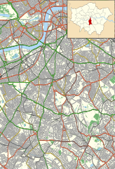
Module:Location map/data/United
Kingdom London Lambeth/doc
887:
Module:Location map/data/United
Kingdom London Lambeth/doc
1035:
Modül:Konum haritası/veri/Birleşik Krallık Londra
Lambeth
253:
88:
420:
Add a one-line explanation of what this file represents
1010:
Module:Location map/data/United
Kingdom London Lambeth
995:
Module:Location map/data/United
Kingdom London Lambeth
882:
Module:Location map/data/United
Kingdom London Lambeth
750:
464:
https:\/\/commons.wikimedia.org\/wiki\/user:Nilfanion
970:ಟೆಂಪ್ಲೇಟು:Location map United Kingdom London Lambeth
915:
Plantilya:Location map United Kingdom London Lambeth
895:
686:
629:
Creative Commons Attribution-ShareAlike 3.0 Unported
603:
Creative Commons Attribution-ShareAlike 3.0 Unported
112:
Commons is a freely licensed media file repository.
1050:Batakan:Location map United Kingdom London Lambeth
925:الگو:Location map United Kingdom London Lambeth
905:قالب:Location map United Kingdom London Lambeth
738:{{Information |Description=Location map of the
277:All other data from VectorMap District product.
842:Royal Waterloo Hospital for Children and Women
384:https://creativecommons.org/licenses/by-sa/3.0
93:
980:സൗത്ത് ലണ്ടൻ ഹോസ്പിറ്റൽ ഫോർ വിമൻ ആൻറ് ചിൽഡ്രൺ
390:Creative Commons Attribution-Share Alike 3.0
308:
293:
249:
130:
847:South London Hospital for Women and Children
525:https://commons.wikimedia.org/user:Nilfanion
283:
259:
14:
350:– to copy, distribute and transmit the work
41:Size of this PNG preview of this SVG file:
897:The following other wikis use this file:
787:Evelina London Children's Hospital
142:with the following information shown:
274:Ward data from Boundary-Line product.
124:
331:Attribution-Share Alike 3.0 Unported
679:
319:
314:
13:
425:
419:
305:
133:Lambeth London UK location map.svg
125:
75:
1063:
424:
751:
410:
361:Under the following conditions:
326:This file is licensed under the
318:
313:
307:
92:
31:
21:
762:All Saints Church, West Dulwich
407:
986:Usage on simple.wikipedia.org
940:Modèle:Géolocalisation/Lambeth
892:
872:The Duke of Edinburgh, Brixton
857:South Thames Retrieval Service
852:South London Liberal Synagogue
827:Old Town Hall, Kennington Road
777:Corpus Christi Church, Brixton
767:Belgrave Hospital for Children
683:
406:
26:
1:
930:کلیسای کورپس کریستی، بریکستون
807:King's College Hospital
772:Children's Day Hospital
747:
432:Items portrayed in this file
7:
1046:Usage on war.wikipedia.org
911:Usage on ceb.wikipedia.org
10:
1068:
1031:Usage on tr.wikipedia.org
1021:Usage on th.wikipedia.org
1006:Usage on si.wikipedia.org
976:Usage on ml.wikipedia.org
966:Usage on kn.wikipedia.org
946:Usage on ja.wikipedia.org
936:Usage on fr.wikipedia.org
921:Usage on fa.wikipedia.org
901:Usage on ar.wikipedia.org
832:Queen's Head, Brixton
802:King's Arms, Waterloo
375:same or compatible license
127:
792:General Lying-In Hospital
740:London Borough of Lambeth
680:
140:London Borough of Lambeth
16:
862:St Thomas' Hospital
822:Old Red Lion, Kennington
409:
341:
99:This is a file from the
36:
737:
716:23:13, 15 November 2011
252:
103:. Information from its
106:description page there
1025:โรงพยาบาลเซนต์ทอมาซิส
837:Royal Vauxhall Tavern
138:Location map of the
65:1,398 × 2,048 pixels
990:County Hall, London
867:The Bobbin, Clapham
782:County Hall, London
757:575 Wandsworth Road
356:– to adapt the work
230:Geographic limits:
174:Non-primary A roads
47:Other resolutions:
877:The London Studios
533:Wikimedia username
505:author name string
468:Wikimedia username
452:author name string
69:864 × 1,266 pixels
61:699 × 1,024 pixels
893:Global file usage
817:Lambeth Town Hall
745:
613:copyright license
599:copyright license
418:
403:
402:
302:
299:Reusing this file
121:
120:
101:Wikimedia Commons
32:Global file usage
1059:
812:Lambeth Hospital
728:
690:
668:15 November 2011
569:copyright status
555:copyright status
542:
537:
527:
522:
512:
509:
416:
397:
394:
391:
388:
385:
377:as the original.
339:
328:Creative Commons
322:
321:
317:
316:
311:
310:
296:
255:
254:15 November 2011
134:
128:
117:
96:
95:
89:
83:
72:
57:524 × 768 pixels
53:327 × 480 pixels
49:164 × 240 pixels
43:409 × 599 pixels
1067:
1066:
1062:
1061:
1060:
1058:
1057:
1056:
891:
753:
746:
734:
726:
682:
681:
678:
677:
676:
675:
674:
673:
672:
671:
669:
659:
658:
657:
655:
640:
639:
638:
637:
636:
635:
634:
633:
631:
619:
618:
617:
615:
596:
595:
594:
593:
592:
591:
590:
589:
587:
575:
574:
573:
571:
552:
551:
550:
549:
548:
547:
546:
545:
544:
543:
538:
535:
529:
528:
523:
520:
514:
513:
510:
507:
498:
497:
496:
494:
484:
483:
482:
480:
445:
444:
443:
442:
441:
439:
423:
422:
421:
404:
399:
398:
395:
392:
389:
386:
383:
382:
340:
337:
334:
323:
265:Ordnance Survey
223:
221:
215:
213:
207:
205:
199:
197:
191:
189:
183:
181:
175:
173:
167:
165:
159:
157:
151:
150:Ward boundaries
149:
132:
123:
122:
111:
110:
109:is shown below.
85:
81:
74:
73:
46:
12:
11:
5:
1065:
1055:
1054:
1053:
1052:
1044:
1043:
1042:
1037:
1029:
1028:
1027:
1019:
1018:
1017:
1012:
1004:
1003:
1002:
997:
992:
984:
983:
982:
974:
973:
972:
964:
963:
962:
957:
952:
950:ロンドン・カウンティ・ホール
944:
943:
942:
934:
933:
932:
927:
919:
918:
917:
909:
908:
907:
894:
890:
889:
884:
879:
874:
869:
864:
859:
854:
849:
844:
839:
834:
829:
824:
819:
814:
809:
804:
799:
794:
789:
784:
779:
774:
769:
764:
759:
749:
744:
743:
736:
732:
729:
723:
718:
713:
709:
708:
705:
702:
699:
696:
693:
685:
670:
667:
665:
664:
663:
661:
660:
656:
651:
649:
648:
647:
646:
644:
632:
627:
625:
624:
623:
621:
620:
616:
611:
609:
608:
607:
606:
604:
600:
588:
583:
581:
580:
579:
577:
576:
572:
567:
565:
564:
563:
562:
560:
556:
531:
530:
516:
515:
503:
502:
501:
500:
499:
495:
492:
490:
489:
488:
486:
485:
481:
476:
474:
473:
472:
471:
469:
465:
461:
457:
453:
449:
440:
435:
433:
430:
429:
428:
427:
415:
414:
411:
408:
401:
400:
381:
380:
379:
378:
368:
359:
358:
357:
351:
344:You are free:
335:
325:
324:
306:
303:
291:
290:
285:
281:
280:
279:
278:
275:
261:
257:
256:
251:
247:
246:
245:
244:
243:South: 51.405N
241:
240:North: 51.515N
238:
235:
225:
224:
219:
218:
216:
211:
210:
208:
203:
202:
200:
195:
194:
192:
187:
186:
184:
179:
178:
176:
171:
170:
168:
166:Primary routes
163:
162:
160:
155:
154:
152:
147:
146:
135:
126:
119:
118:
97:
87:
86:
40:
35:
34:
29:
24:
19:
9:
6:
4:
3:
2:
1064:
1051:
1048:
1047:
1045:
1041:
1038:
1036:
1033:
1032:
1030:
1026:
1023:
1022:
1020:
1016:
1013:
1011:
1008:
1007:
1005:
1001:
998:
996:
993:
991:
988:
987:
985:
981:
978:
977:
975:
971:
968:
967:
965:
961:
958:
956:
953:
951:
948:
947:
945:
941:
938:
937:
935:
931:
928:
926:
923:
922:
920:
916:
913:
912:
910:
906:
903:
902:
900:
899:
898:
888:
885:
883:
880:
878:
875:
873:
870:
868:
865:
863:
860:
858:
855:
853:
850:
848:
845:
843:
840:
838:
835:
833:
830:
828:
825:
823:
820:
818:
815:
813:
810:
808:
805:
803:
800:
798:
795:
793:
790:
788:
785:
783:
780:
778:
775:
773:
770:
768:
765:
763:
760:
758:
755:
754:
741:
735:
730:
724:
722:
719:
717:
714:
711:
710:
706:
703:
700:
697:
694:
692:
691:
689:
666:
654:
650:
630:
626:
614:
610:
586:
582:
570:
566:
541:
534:
526:
519:
506:
491:
479:
475:
438:
434:
431:
412:
405:
387:CC BY-SA 3.0
376:
372:
369:
366:
363:
362:
360:
355:
352:
349:
346:
345:
343:
342:
336:Attribution:
332:
329:
312:
304:
300:
295:
292:
289:
286:
282:
276:
273:
272:
271:
269:
266:
262:
258:
248:
242:
239:
236:
233:
232:
231:
228:
217:
209:
201:
193:
185:
177:
169:
161:
153:
145:
144:
143:
141:
136:
129:
115:
108:
107:
102:
98:
91:
90:
84:
79:
78:Original file
70:
66:
62:
58:
54:
50:
44:
39:
33:
30:
28:
25:
23:
20:
18:
15:
896:
725:864 × 1,266
687:
684:File history
370:
364:
353:
347:
263:
229:
226:
137:
114:You can help
104:
76:
22:File history
960:ザ・ロンドン・スタジオ
585:copyrighted
559:copyrighted
371:share alike
365:attribution
237:East: 0.05W
234:West: 0.17W
190:Minor roads
131:Description
797:Kennington
748:File usage
701:Dimensions
493:some value
294:Permission
27:File usage
733:Nilfanion
727:(4.38 MB)
698:Thumbnail
695:Date/Time
653:inception
643:inception
540:Nilfanion
511:Nilfanion
456:Nilfanion
288:Nilfanion
222:Buildings
158:Motorways
413:Captions
354:to remix
348:to share
333:license.
268:OpenData
214:Woodland
198:Railways
955:帝国戦争博物館
712:current
707:Comment
478:creator
448:creator
437:depicts
417:English
182:B roads
80:
284:Author
260:Source
220:
212:
204:
196:
188:
180:
172:
164:
156:
148:
206:Water
704:User
396:true
393:true
250:Date
17:File
518:URL
460:URL
536::
521::
508::
270:.
67:|
63:|
59:|
55:|
51:|
45:.
301:)
297:(
116:.
71:.
