294:
1058:"}},"text\/plain":{"en":{"":"inception"}}},"{\"value\":{\"time\":\"+2008-11-12T00:00:00Z\",\"timezone\":0,\"before\":0,\"after\":0,\"precision\":11,\"calendarmodel\":\"http:\\\/\\\/www.wikidata.org\\\/entity\\\/Q1985727\"},\"type\":\"time\"}":{"text\/html":{"en":{"P571":"12 November 2008"}},"text\/plain":{"en":{"P571":"12 November 2008"}}}}": -->
763:
716:
285:
769:
276:
647:
86:
685:
997:"}},"text\/plain":{"en":{"P275":"Creative Commons Attribution-ShareAlike 3.0 Unported"}}},"{\"value\":{\"entity-type\":\"item\",\"numeric-id\":50829104,\"id\":\"Q50829104\"},\"type\":\"wikibase-entityid\"}":{"text\/html":{"en":{"P275":"
774:
993:"}},"text\/plain":{"en":{"":"copyright license"}}},"{\"value\":{\"entity-type\":\"item\",\"numeric-id\":14946043,\"id\":\"Q14946043\"},\"type\":\"wikibase-entityid\"}":{"text\/html":{"en":{"P275":"
949:"}},"text\/plain":{"en":{"":"copyright status"}}},"{\"value\":{\"entity-type\":\"item\",\"numeric-id\":50423863,\"id\":\"Q50423863\"},\"type\":\"wikibase-entityid\"}":{"text\/html":{"en":{"P6216":"
1096:"}},"text\/plain":{"en":{"":"media type"}}},"{\"value\":\"image\\\/png\",\"type\":\"string\"}":{"text\/html":{"en":{"P1163":"image\/png"}},"text\/plain":{"en":{"P1163":"image\/png"}}}}": -->
1092:
1172:
900:{{Information |Beschreibung = Ost- (Kangshung-) Wand des Mount Everest mit Umgebung |Quelle = NASA & eigene Arbeit (Linien und Punkte markiert) |Urheber = NASA |Datum = 12.11.2008 |Genehmigung = US-Gov-GFDL |Andere Versionen = |Anmerkungen = }}
834:– You must give appropriate credit, provide a link to the license, and indicate if changes were made. You may do so in any reasonable manner, but not in any way that suggests the licensor endorses you or your use.
546:
which is the connection on 6006m of the glacier systems of Rongbu and Khumbu and is also the tibetian-nepalian borderline / like SE ridge & W ridge. Lho La is "foot point" of the
Everest W ridge.)
1182:
1189:{{BotMoveToCommons|de.wikipedia}} {{Information |Description={{de|Ost- (Kangshung-) Wand des Mount Everest mit Umgebung}} |Source=Transferred from ; transferred to Commons by
998:
994:
950:
379:“Phantasy Ridge” (acc. to a speech of George Mallory), no successful ascent until 2008, tried by Cathy O’Dowd and Ian Woodall; they came half way to NE ridge & Pinnacles
1360:
1093:
946:
1055:
990:
733:
1001:"}},"text\/plain":{"en":{"P275":"GNU Free Documentation License, version 1.2 or later"}}}}": -->
258:
731:; with no Invariant Sections, no Front-Cover Texts, and no Back-Cover Texts. A copy of the license is included in the section entitled
1041:
1024:
976:
1355:
1207:
1375:
841:
1103:
960:
723:
1065:
1008:
935:
249:
1370:
1350:
351:
upper SE ridge (part of the «Hillary route» 1953 etc. coming from
Western Qwm (in the shadow behind Mt. Everest)
1222:
52:
48:
42:
783:
796:
700:
97:
895:
728:
245:
65:
840:– If you remix, transform, or build upon the material, you must distribute your contributions under the
480:
ABC Advanced Base Camp (North) on the upper East
Rongbuk Glacier in front of the ice wall to north col
953:"}},"text\/plain":{"en":{"P6216":"copyrighted"}}}}": -->
1203:
The following pages on the
English Knowledge use this file (pages on other projects are not listed):
1325:
105:
1340:
1310:
293:
855:
721:
Permission is granted to copy, distribute and/or modify this document under the terms of the
780:
224:
8:
220:
672:
1300:
1190:
668:
427:
597:
to the Base camp on foot of the Main
Rongbuk Glacier and to Rongbuk Gompa (Monastery)
707:, the copyright holder of this work, hereby publishes it under the following license:
555:
327:
Normal route, mainly the
Mallory route 1924, via high camps on 7700 and 8300 m, via "
92:
1265:
925:
567:
1171:
1166:
56:
37:
1405:
1400:
1395:
1217:
663:. NASA copyright policy states that "NASA material is not protected by copyright
578:
442:
887:
1212:
655:
493:
608:(connection from Eastern Rongbuk Glacier System to Kangshung Glacier System)
524:
1250:
332:
328:
118:
1113:
1075:
1035:
1018:
970:
438:
1420:
1410:
676:
284:
539:
1240:
605:
528:
504:
469:
275:
119:
710:
1139:
Click on a date/time to view the file as it appeared at that time.
489:
543:
514:
1290:
558:
offering a tough ascent to NE ridge without going via north col
1415:
1315:
1330:
854:
This licensing tag was added to this file as part of the GFDL
1285:
1275:
660:
1295:
1280:
800:
704:
1270:
581:(Mallory 1921, where discovered the access to North Col)
80:
1260:
919:
Add a one-line explanation of what this file represents
353:
meeting point with the orange route 7a is the south col
659:
in the United States because it was solely created by
355:
meeting point with the orange route 7b is the balcony
1385:
1201:
196:
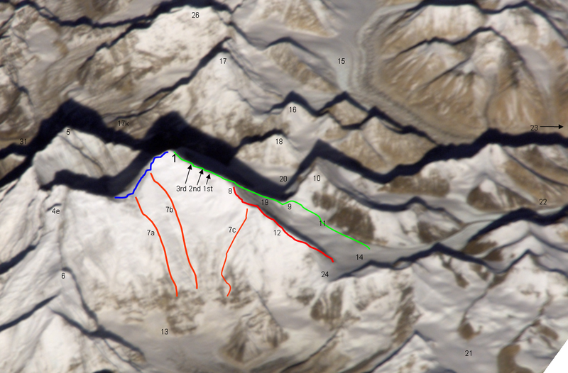
Ost- (Kangshung-) Wand des Mount
Everest mit Umgebung
1231:
1137:
1042:
1025:
Creative
Commons Attribution-ShareAlike 3.0 Unported
999:
995:
Creative Commons Attribution-ShareAlike 3.0 Unported
727:, Version 1.2 or any later version published by the
104:
Commons is a freely licensed media file repository.
70:(1,157 × 761 pixels, file size: 1.95 MB, MIME type:
589:Camp II of the early british expeditions 1922+1924
395:steps on the Upper NE ridge 8700m, 8605m and 8530m
890:. All following user names refer to de.wikipedia.
363:1988 US and GB ascent (Stephen Vernables et al.)
371:1982 US ascent (Carlos Buhler, Kim Momb et al.)
1326:Expédition britannique à l'Everest de 1924
861:http://creativecommons.org/licenses/by-sa/3.0/
85:
762:
201:
183:
867:Creative Commons Attribution-Share Alike 3.0
265:
231:
215:
209:
14:
817:– to copy, distribute and transmit the work
1301:Benutzer Diskussion:Rupert Pupkin/Alteisen
1233:The following other wikis use this file:
331:", exit cracks & upper NE ridge w. "
163:
125:
1341:Expediția britanică pe Everest din 1924
1311:Expedición británica al Everest de 1924
1266:Britische Mount-Everest-Expedition 1924
205:12 November 2008 (original upload date)
881:
488:West Rongbuk Glacier (coming from the
1208:1924 British Mount Everest expedition
646:
116:
784:Attribution-Share Alike 3.0 Unported
757:
739:http://www.gnu.org/copyleft/fdl.html
641:
554:north ridge // below of fig. 19 the
1130:
773:
768:
13:
924:
918:
886:The original description page was
885:
699:
683:
190:
120:
117:
63:
1434:
923:
121:
1202:
909:
828:Under the following conditions:
779:This file is licensed under the
772:
767:
761:
715:
714:
645:
531:View Point” from the south side
292:
283:
274:
84:
31:
21:
1184:File Upload Bot (Magnus Manske)
906:
1251:Rute penjanja na Mount Everest
1228:
1223:User talk:RedWolf/2008 Archive
1134:
905:
745:GNU Free Documentation License
734:GNU Free Documentation License
724:GNU Free Documentation License
387:summit of Mount Everest 8848m
191:
153:
26:
1:
280:Zoomed with image annotations
1198:
931:Items portrayed in this file
614:
131:
7:
323:
269:
10:
1439:
1392:Usage on zh.wikipedia.org
1382:Usage on www.wikidata.org
1367:Usage on uk.wikipedia.org
1347:Usage on ru.wikipedia.org
1337:Usage on ro.wikipedia.org
1322:Usage on fr.wikipedia.org
1307:Usage on es.wikipedia.org
1257:Usage on de.wikipedia.org
1247:Usage on bs.wikipedia.org
1237:Usage on az.wikipedia.org
898:1157×761× (2046200 bytes)
842:same or compatible license
673:NASA copyright policy page
343:lower and middle NE ridge
180:
175:
141:
1131:
788:
760:
445:died 1982 (2nd pinnacle)
16:
908:
729:Free Software Foundation
437:“Three Pinnacles” where
316:
91:This is a file from the
36:
1361:Поиски Мэллори и Ирвина
1188:
1167:21:59, 26 November 2008
204:
95:. Information from its
688:
619:Original photograph:
98:description page there
41:Size of this preview:
687:
461:East Rongbuk Glacier
896:Kassander der Minoer
797:Kassander der Minoer
701:Kassander der Minoer
677:JPL Image Use Policy
653:This file is in the
246:Kassander der Minoer
1291:Edward Felix Norton
882:Original upload log
823:– to adapt the work
453:North Col on 7050m
168:Original upload log
47:Other resolutions:
1316:Cara del Kangshung
1193:using [http://tool
1191:User:Rupert Pupkin
695:Lines and points:
689:
472:(northern summit)
57:1,157 × 761 pixels
1331:Face du Kangshung
1229:Global file usage
1196:
1009:copyright license
991:copyright license
917:
894:2008-11-12 20:39
878:
877:
756:
755:
693:
692:
669:Template:PD-USGov
640:
639:
612:
611:
428:Kangshung Glacier
340:red line / no.12
313:
312:
309:
308:
298:Higher resolution
243:Derivative work:
213:Transferred from
126:
113:
112:
93:Wikimedia Commons
32:Global file usage
1430:
1356:Кангшунг (стена)
1286:Stephen Venables
1276:David Breashears
1179:
1141:
1081:12 November 2008
961:copyright status
947:copyright status
915:
874:
871:
868:
865:
862:
859:
856:licensing update
844:as the original.
804:
803:
801:German Knowledge
781:Creative Commons
776:
775:
771:
770:
765:
764:
758:
752:
749:
746:
743:
740:
718:
717:
711:
705:German Knowledge
686:
649:
648:
642:
636:
633:
630:
627:
622:
621:
556:Zakharov Couloir
542:(summit west of
321:
320:
296:
287:
278:
270:
257:
256:
218:
195:
187:
186:Kangshung-06.PNG
181:
169:
166:
159:
156:
147:
144:
137:
134:
127:
109:
88:
87:
81:
75:
73:
60:
53:640 × 421 pixels
49:320 × 210 pixels
43:800 × 526 pixels
1438:
1437:
1433:
1432:
1431:
1429:
1428:
1427:
1296:Three Pinnacles
1241:Kanqşunq divarı
1227:
1218:Three Pinnacles
1204:
1197:
1185:
1177:
1133:
1132:
1129:
1128:
1127:
1126:
1125:
1124:
1123:
1122:
1120:
1110:
1109:
1108:
1106:
1091:
1090:
1089:
1088:
1087:
1086:
1085:
1084:
1082:
1072:
1071:
1070:
1068:
1053:
1052:
1051:
1050:
1049:
1048:
1047:
1046:
1044:
1033:
1032:
1031:
1030:
1029:
1027:
1015:
1014:
1013:
1011:
988:
987:
986:
985:
984:
983:
982:
981:
979:
967:
966:
965:
963:
944:
943:
942:
941:
940:
938:
922:
921:
920:
891:
884:
879:
872:
869:
866:
863:
860:
853:
795:
793:
750:
747:
744:
741:
738:
709:
708:
684:
634:
631:
628:
625:
617:
568:Rongbuk Glacier
376:orange line 7c
368:orange line 7b
360:orange line 7a
319:
314:
299:
290:
281:
254:
252:
214:
197:
185:
178:
173:
167:
164:
157:
154:
145:
142:
135:
132:
128:
124:
115:
114:
103:
102:
101:is shown below.
77:
71:
69:
62:
61:
46:
12:
11:
5:
1436:
1426:
1425:
1424:
1423:
1418:
1413:
1408:
1403:
1398:
1390:
1389:
1388:
1380:
1379:
1378:
1376:Стіна Кангшунг
1373:
1365:
1364:
1363:
1358:
1353:
1345:
1344:
1343:
1335:
1334:
1333:
1328:
1320:
1319:
1318:
1313:
1305:
1304:
1303:
1298:
1293:
1288:
1283:
1281:Kangshung-Wand
1278:
1273:
1268:
1263:
1255:
1254:
1253:
1245:
1244:
1243:
1230:
1226:
1225:
1220:
1215:
1213:Kangshung Face
1210:
1200:
1195:
1194:
1187:
1183:
1180:
1174:
1169:
1164:
1160:
1159:
1156:
1153:
1150:
1147:
1144:
1136:
1121:
1118:
1116:
1115:
1114:
1112:
1111:
1107:
1102:
1100:
1099:
1098:
1097:
1095:
1083:
1080:
1078:
1077:
1076:
1074:
1073:
1069:
1064:
1062:
1061:
1060:
1059:
1057:
1045:
1040:
1038:
1037:
1036:
1034:
1028:
1023:
1021:
1020:
1019:
1017:
1016:
1012:
1007:
1005:
1004:
1003:
1002:
1000:
996:
992:
980:
975:
973:
972:
971:
969:
968:
964:
959:
957:
956:
955:
954:
952:
948:
939:
934:
932:
929:
928:
927:
926:
914:
913:
910:
907:
903:
902:
883:
880:
876:
875:
850:
849:
848:
847:
846:
845:
835:
826:
825:
824:
818:
811:You are free:
806:
805:
790:
789:
787:
777:
754:
753:
719:
698:
697:
691:
690:
681:
650:
638:
637:
616:
613:
610:
609:
603:
599:
598:
595:
591:
590:
587:
583:
582:
579:Kharta Glacier
575:
571:
570:
564:
560:
559:
552:
548:
547:
537:
533:
532:
522:
518:
517:
512:
508:
507:
502:
498:
497:
486:
482:
481:
478:
474:
473:
467:
463:
462:
459:
455:
454:
451:
447:
446:
443:Peter Boardman
435:
431:
430:
425:
421:
420:
417:
413:
412:
409:
405:
404:
401:
397:
396:
393:
389:
388:
385:
381:
380:
377:
373:
372:
369:
365:
364:
361:
357:
356:
349:
345:
344:
341:
337:
336:
325:
318:
315:
311:
310:
307:
306:
291:
282:
273:
267:
266:Other versions
263:
262:
233:
229:
228:
219:to Commons by
211:
207:
206:
203:
199:
198:
188:
179:
177:
174:
172:
171:
161:
151:
150:
149:
123:
111:
110:
89:
79:
78:
40:
35:
34:
29:
24:
19:
9:
6:
4:
3:
2:
1435:
1422:
1419:
1417:
1414:
1412:
1409:
1407:
1404:
1402:
1399:
1397:
1394:
1393:
1391:
1387:
1384:
1383:
1381:
1377:
1374:
1372:
1369:
1368:
1366:
1362:
1359:
1357:
1354:
1352:
1349:
1348:
1346:
1342:
1339:
1338:
1336:
1332:
1329:
1327:
1324:
1323:
1321:
1317:
1314:
1312:
1309:
1308:
1306:
1302:
1299:
1297:
1294:
1292:
1289:
1287:
1284:
1282:
1279:
1277:
1274:
1272:
1271:Russell Brice
1269:
1267:
1264:
1262:
1259:
1258:
1256:
1252:
1249:
1248:
1246:
1242:
1239:
1238:
1236:
1235:
1234:
1224:
1221:
1219:
1216:
1214:
1211:
1209:
1206:
1205:
1192:
1186:
1181:
1175:
1173:
1170:
1168:
1165:
1162:
1161:
1157:
1154:
1151:
1148:
1145:
1143:
1142:
1140:
1117:
1105:
1101:
1079:
1067:
1063:
1043:
1039:
1026:
1022:
1010:
1006:
978:
974:
962:
958:
937:
933:
930:
911:
904:
901:
897:
893:
892:
889:
857:
852:
851:
843:
839:
836:
833:
830:
829:
827:
822:
819:
816:
813:
812:
810:
809:
808:
807:
802:
798:
794:Attribution:
792:
791:
785:
782:
778:
766:
759:
736:
735:
730:
726:
725:
720:
713:
712:
706:
702:
696:
682:
680:
678:
674:
670:
666:
662:
658:
657:
656:public domain
651:
644:
643:
629:Public domain
626:Public domain
624:
623:
620:
607:
604:
601:
600:
596:
593:
592:
588:
585:
584:
580:
576:
573:
572:
569:
565:
562:
561:
557:
553:
550:
549:
545:
541:
538:
535:
534:
530:
526:
523:
520:
519:
516:
513:
510:
509:
506:
503:
500:
499:
495:
494:Gyachung Kang
491:
487:
484:
483:
479:
476:
475:
471:
468:
465:
464:
460:
457:
456:
452:
449:
448:
444:
440:
436:
433:
432:
429:
426:
423:
422:
418:
415:
414:
410:
407:
406:
402:
399:
398:
394:
391:
390:
386:
383:
382:
378:
375:
374:
370:
367:
366:
362:
359:
358:
354:
352:
350:
347:
346:
342:
339:
338:
334:
330:
326:
322:
305:
304:
302:
301:
297:
295:
289:With callouts
288:
286:
279:
277:
272:
271:
268:
264:
260:
251:
247:
244:
241:
240:
238:
234:
230:
226:
225:CommonsHelper
222:
221:Rupert Pupkin
217:
212:
208:
200:
194:
189:
182:
170:
162:
160:
152:
148:
140:
139:
138:
130:
129:
107:
100:
99:
94:
90:
83:
82:
76:
67:
66:Original file
58:
54:
50:
44:
39:
33:
30:
28:
25:
23:
20:
18:
15:
1371:Три башточки
1351:Три жандарма
1232:
1176:1,157 × 761
1138:
1135:File history
899:
864:CC BY-SA 3.0
837:
831:
820:
814:
732:
722:
694:
665:unless noted
664:
654:
652:
618:
525:Kala Patthar
403:Lhotse Shar
392:3rd 2nd 1st
303:
300:
242:
237:Photograph:
236:
235:
216:de.wikipedia
192:
106:You can help
96:
64:
22:File history
1261:Appa Sherpa
977:copyrighted
951:copyrighted
838:share alike
832:attribution
527:, “Everest
333:Second Step
329:yellow band
324:green line
184:Description
1199:File usage
1152:Dimensions
1104:media type
1094:media type
439:Joe Tasker
419:“Peak 38”
348:blue line
27:File usage
1178:(1.95 MB)
1149:Thumbnail
1146:Date/Time
1119:image/png
1066:inception
1056:inception
786:license.
615:Licensing
540:Khumbutse
193:Deutsch:
158:Licensing
72:image/png
1386:Q1723748
912:Captions
821:to remix
815:to share
667:". (See
606:Rapiu La
529:Trekking
505:Lingtren
496:flanks)
470:Changtse
259:contribs
122:Contents
1163:current
1158:Comment
936:depicts
916:English
490:Cho Oyu
411:Nuptse
176:Summary
136:Summary
68:
577:upper
544:Lho La
515:Pumori
253:
232:Author
223:using
210:Source
635:false
632:false
566:Main
317:Notes
146:Notes
1406:坤布崎峰
1401:普莫里峰
1396:绒布冰川
1155:User
888:here
873:true
870:true
751:true
748:true
742:GFDL
661:NASA
521:17k
492:and
441:and
250:talk
239:NASA
202:Date
17:File
1421:康雄壁
1411:凌川峰
799:at
703:at
675:or
602:24
594:23
586:22
574:21
563:20
551:19
536:18
511:17
501:16
485:15
477:11
466:10
458:14
424:13
400:4e
335:")
143:1.1
1416:北坳
679:.)
671:,
450:9
434:8
416:6
408:5
384:1
55:|
51:|
45:.
858:.
737:.
261:)
255:·
248:(
227:.
165:3
155:2
133:1
108:.
74:)
59:.
Text is available under the Creative Commons Attribution-ShareAlike License. Additional terms may apply.


