43:
323:
763:
412:
517:
329:
334:
770:
1407:
99:
982:"}},"text\/plain":{"en":{"":"copyright license"}}},"{\"value\":{\"entity-type\":\"item\",\"numeric-id\":14946043,\"id\":\"Q14946043\"},\"type\":\"wikibase-entityid\"}":{"text\/html":{"en":{"P275":"
938:"}},"text\/plain":{"en":{"":"copyright status"}}},"{\"value\":{\"entity-type\":\"item\",\"numeric-id\":50423863,\"id\":\"Q50423863\"},\"type\":\"wikibase-entityid\"}":{"text\/html":{"en":{"P6216":"
1026:"}},"text\/plain":{"en":{"":"source of file"}}},"{\"value\":{\"entity-type\":\"item\",\"numeric-id\":66458942,\"id\":\"Q66458942\"},\"type\":\"wikibase-entityid\"}":{"text\/html":{"en":{"P7482":"
1382:
1022:
978:
1108:
1155:{{WikiProject_India_Maps |Title=The Rashtrakuta Empire 750-900BC |Description=Map showing the extent of the Rashtrakuta empires. {{legend|#FF9F80|Extent of Rashtrakuta Empire, 780 C.E.}} |Source= "John Keay, History of India, 2000, Grove publications, Ne
1552:
1622:
1282:
1507:
415:
The frontiers depicted on the Indian maps in
Knowledge are from a neutral point of view and may differ from official government maps of India, Pakistan and China. Please consult local laws governing publication of maps before
375:– You must give appropriate credit, provide a link to the license, and indicate if changes were made. You may do so in any reasonable manner, but not in any way that suggests the licensor endorses you or your use.
746:
This map is meant to be for illustrative purpose only and is not authenticated by official government sources. Please check the list of sources and references used to create the map for a measure of accuracy and
1652:
1522:
1572:
1377:
1277:
790:
administrative boundary recognised by the international community. This UN ceasefire line is considered as a temporary solution to an ongoing conflict since the departure of the
British Raj.
799:
The depicted extent of the former territory of the
British Indian Empire, succeeded by Republic of India, may not be accepted by few countries as legal due to ongoing border disputes:
172:
1512:
1267:
750:
The usage of these maps in India, Pakistan and China are governed by different laws that restrict depictions of boundaries other than what is officially recognized by the state.
859:
The borders of the state of
Meghalaya, Assam and Arunachal Pradesh are shown as interpreted from the North-Eastern Areas (Reorganisation) Act, 1971, but has yet to be verified.
1027:
983:
939:
1023:
935:
839:
Minor areas of eastern
Kashmir's Ladakh division, Himachal Pradesh and Uttarakhand on the Chinese frontier are claimed by China. These areas are under Indian control.
979:
1547:
1367:
1322:
1257:
1661:
1582:
731:
The territorial boundaries of India are shown as per the actual ground situation in accordance with international practices followed by the United
Nations (
1502:
1387:
1452:
73:
69:
65:
61:
57:
53:
47:
1587:
1497:
1492:
1224:
110:
986:"}},"text\/plain":{"en":{"P275":"Creative Commons Attribution-ShareAlike 3.0 Unported"}}}}": -->
82:
738:
482:
450:
1542:
1337:
1247:
559:
527:
1462:
888:
883:
735:
306:
1332:
1194:
1053:
1009:
965:
1229:
1214:
1442:
1672:
This file contains additional information, probably added from the digital camera or scanner used to create or digitize it.
1137:
1132:
382:
867:
The limit of the territorial waters of India extends to twelve nautical miles measured from the appropriate baseline. See
1179:
829:(shown white) is an actively contested region between India and Pakistan. Since 1984, the region is under Indian control.
1037:
949:
1209:
1030:"}},"text\/plain":{"en":{"P7482":"original creation by uploader"}}}}": -->
848:
282:
993:
924:
842:
A small area of
Uttarakhand adjoining the Nepal border along the Sarda river is disputed between the two countries.
221:
225:
217:
344:
229:
1675:
If the file has been modified from its original state, some details may not fully reflect the modified file.
804:
1612:
381:– If you remix, transform, or build upon the material, you must distribute your contributions under the
780: : The territory India claims is legally theirs, but the claim is disputed by China and Pakistan.
206:
942:"}},"text\/plain":{"en":{"P6216":"copyrighted"}}}}": -->
1165:
The following pages on the
English Knowledge use this file (pages on other projects are not listed):
1472:
1184:
1107:
1102:
42:
1432:
261:
1169:
820:
118:
732:
868:
1174:
341:
265:
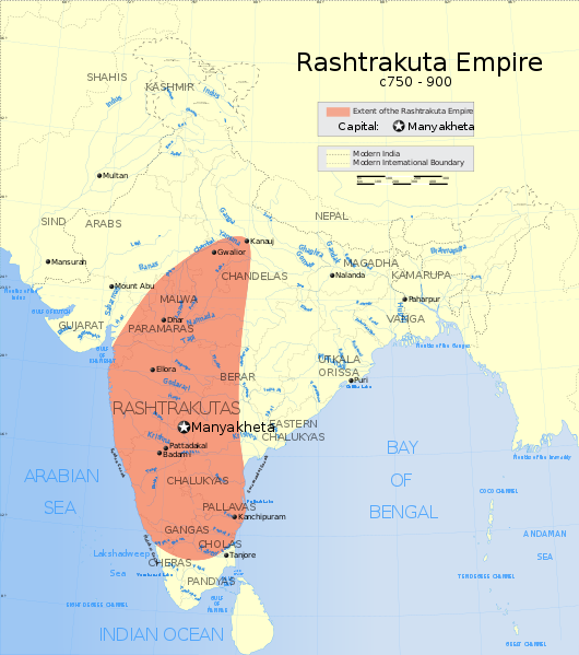
8:
1617:
833:
105:
914:
316:
I, the copyright holder of this work, hereby publish it under the following license:
826:
816:
598:
1397:
1189:
294:
249:
1312:
741:
233:
1148:
1118:
808:
762:
574:
561:
542:
529:
497:
484:
465:
452:
257:
1482:
1219:
1199:
633:
411:
1047:
1003:
959:
812:
516:
171:
1597:
1408:Աշխարհի պատմության խոշորագույն տերությունների (կայսրությունների) ցանկ
1204:
836:
is almost entirely claimed by China as part of its
Tibetan territory.
634:
622:
1642:
1602:
1075:
Click on a date/time to view the file as it appeared at that time.
815:). Since 1972, it is divided between all three countries. See also
1562:
752:
Please check local laws and modify the map accordingly before use.
273:"John Keay, History of India, 2000, Grove publications, New York,
213:
202:
245:
1532:
1417:
769:
847:
For a detailed map of all disputed regions in South Asia, see
275:
241:
87:(SVG file, nominally 1,639 × 1,852 pixels, file size: 410 KB)
1632:
93:
1427:
1357:
1347:
1307:
1297:
803:
The northern
Himalayan region of the disputed territory
908:
Add a one-line explanation of what this file represents
666:
607:
If inappropriate please set warp_status = skip to hide.
433:
184:
1433:
Utente:Adeyang/Cronologia delle scoperte scientifiche
1163:
757:
1238:
1073:
1010:
Creative Commons Attribution-ShareAlike 3.0 Unported
984:
Creative Commons Attribution-ShareAlike 3.0 Unported
117:
Commons is a freely licensed media file repository.
593:
166:
154:Map showing the extent of the Rashtrakuta empires.
617:
135:
656:
441:
425:
676:
725:
1225:Portal:India/SC Summary/SA Rashtrakuta Dynasty
794:
392:https://creativecommons.org/licenses/by-sa/3.0
98:
398:Creative Commons Attribution-Share Alike 3.0
322:
301:
180:
145:
289:
190:
14:
358:– to copy, distribute and transmit the work
46:Size of this PNG preview of this SVG file:
132:
1240:The following other wikis use this file:
811:) and the Chinese-occupied territory of (
640:
429:second half of 20 century and 21 century
1195:Political history of medieval Karnataka
737:) and the National Geographic Society (
696:
601:Georeference the map in Wikimaps Warper
1623:Список крупнейших государств в истории
1383:हिन्दू साम्राज्यों और राजवंशों की सूची
1230:Portal:India/Selected articles/Archive
1215:Knowledge talk:WikiProject Indian maps
160:Extent of Rashtrakuta Empire, 780 C.E.
862:
708:
686:
129:
889:Indian Rashtrakuta Empire map-es.svg
884:Indian Rashtrakuta Empire map de.svg
345:Attribution-Share Alike 3.0 Unported
1180:List of Hindu empires and dynasties
1066:
874:
854:
333:
328:
276:
274:
13:
1670:
1288:হিন্দু সাম্রাজ্য ও রাজবংশের তালিকা
1210:Timeline of scientific discoveries
913:
907:
849:Image:India disputed areas map.svg
768:
761:
758:Explanation of disputed boundaries
671:Explanation of disputed boundaries
635:
319:
315:
170:
130:
80:
1704:
1677:
1313:Usuari:Jolle/Dinastia Raixtrakuta
912:
636:
148:Indian Rashtrakuta Empire map.svg
140:The Rashtrakuta Empire 750-900BC
1164:
898:
784:Line of Control/Line of Conflict
515:
410:
369:Under the following conditions:
340:This file is licensed under the
332:
327:
321:
97:
31:
21:
895:
879:Derivative works of this file:
807:is claimed by India including (
214:University of Texas map library
203:University of Texas map library
1639:Usage on simple.wikipedia.org
1235:
1070:
894:
832:The northeastern territory of
239:State and District boundaries:
26:
1:
1054:original creation by uploader
1028:original creation by uploader
809:Pakistan-administered Kashmir
599:
36:
1160:
920:Items portrayed in this file
726:Depiction of India's borders
661:Depiction of India's borders
262:Survey of India Map Explorer
7:
1667:
1579:Usage on pnb.wikipedia.org
1319:Usage on en.wiktionary.org
1254:Usage on azb.wikipedia.org
805:Indian-administered Kashmir
795:Borders of disputed regions
681:Borders of disputed regions
10:
1709:
1649:Usage on si.wikipedia.org
1629:Usage on sh.wikipedia.org
1609:Usage on ru.wikipedia.org
1594:Usage on pt.wikipedia.org
1569:Usage on or.wikipedia.org
1559:Usage on no.wikipedia.org
1539:Usage on ne.wikipedia.org
1529:Usage on ms.wikipedia.org
1519:Usage on mr.wikipedia.org
1489:Usage on ml.wikipedia.org
1479:Usage on lt.wikipedia.org
1469:Usage on ko.wikipedia.org
1459:Usage on kn.wikipedia.org
1449:Usage on ka.wikipedia.org
1439:Usage on ja.wikipedia.org
1424:Usage on it.wikipedia.org
1414:Usage on id.wikipedia.org
1404:Usage on hy.wikipedia.org
1398:India uralkodóinak listája
1394:Usage on hu.wikipedia.org
1374:Usage on hi.wikipedia.org
1364:Usage on gu.wikipedia.org
1354:Usage on fr.wikipedia.org
1344:Usage on fi.wikipedia.org
1329:Usage on fa.wikipedia.org
1304:Usage on ca.wikipedia.org
1294:Usage on br.wikipedia.org
1274:Usage on bn.wikipedia.org
1264:Usage on ba.wikipedia.org
1244:Usage on ar.wikipedia.org
646:
445:
383:same or compatible license
1598:Lista de Estados extintos
1553:पश्चिमी चालुक्य साम्राज्य
1508:ധ്രുവ (രാഷ്ട്രകൂട രാജാവ്)
1268:Иң ҙур дәүләттәр исемлеге
1067:
612:
420:
195:
16:
1283:পশ্চিম চালুক্য সাম্রাজ্য
1185:Middle kingdoms of India
897:
778:Boundary of Indian claim
720:
434:Spatial reference system
349:
207:India Political map 2001
104:This is a file from the
41:
1170:Chalukyas of Vemulavada
1154:
1124:
108:. Information from its
871:for more information.
821:Line of Actual Control
773:
766:
623:WikiProject India Maps
421: Geotemporal data
246:2001 Census State Maps
200:International Borders:
175:
111:description page there
1563:Rashtrakuta-dynastiet
772:
765:
271:Map specific sources:
174:
1583:راشٹرکوٹ شاہی خاندان
1483:Raštrakutų dinastija
1175:History of Karnataka
1133:18:57, 27 April 2007
250:Survey of India Maps
74:1,639 × 1,852 pixels
70:1,812 × 2,048 pixels
1653:රාෂ්ට්රකූට රාජවංශය
1533:Dinasti Rashtrakuta
1523:राष्ट्रकूट राजघराणे
1418:Dinasti Rashtrakuta
1258:راشترکوته شاهلیلار
613: Archival data
364:– to adapt the work
266:Columbia University
258:US Army Map Service
230:Kashmir Region 2004
226:Western Sector 1988
222:Eastern Sector 1988
218:China-India Borders
52:Other resolutions:
1643:Rashtrakuta Empire
1588:مغربی چلوکیہ سلطنت
1125:remove Adobe cruft
1103:02:47, 9 July 2013
863:Territorial waters
774:
767:
701:Territorial waters
176:
66:906 × 1,024 pixels
1696:
1695:
1662:more global usage
1603:Império Chaluquia
1573:ରାଷ୍ଟ୍ରକୁଟ ରାଜବଂଶ
1378:राष्ट्रकूट राजवंश
1278:রাষ্ট্রকূট রাজবংশ
1236:Global file usage
1158:
994:copyright license
980:copyright license
906:
834:Arunachal Pradesh
641:
628:
627:
608:
589:
588:
310:
307:Reusing this file
211:Disputed Borders:
126:
125:
106:Wikimedia Commons
32:Global file usage
1700:
1678:
1513:ഗോവിന്ദ മൂന്നാമൻ
1338:دودمان راشترکوته
1248:سلالة راشتراكوتا
1145:
1115:
1077:
950:copyright status
936:copyright status
904:
875:derivative works
855:Internal borders
714:
713:derivative works
711:
702:
699:
692:
691:Internal borders
689:
682:
679:
672:
669:
662:
659:
652:
649:
642:
606:
605:
603:
602:
585:
583:
582:
581:
576:
572:
571:
568:
567:
564:
553:
551:
550:
549:
544:
540:
539:
536:
535:
532:
519:
508:
506:
505:
504:
499:
498:38.57°N 100.05°E
495:
494:
491:
490:
487:
476:
474:
473:
472:
467:
463:
462:
459:
458:
455:
446:
414:
405:
402:
399:
396:
393:
385:as the original.
342:Creative Commons
336:
335:
331:
330:
325:
324:
304:
280:
278:
197:
186:
149:
133:
122:
101:
100:
94:
88:
77:
62:680 × 768 pixels
58:425 × 480 pixels
54:212 × 240 pixels
48:530 × 599 pixels
1708:
1707:
1703:
1702:
1701:
1699:
1698:
1697:
1666:
1333:امپراتوری گوپتا
1234:
1190:North Karnataka
1166:
1159:
1151:
1143:
1121:
1113:
1069:
1068:
1065:
1064:
1063:
1062:
1061:
1060:
1059:
1058:
1056:
1044:
1043:
1042:
1040:
1021:
1020:
1019:
1018:
1017:
1016:
1015:
1014:
1012:
1000:
999:
998:
996:
977:
976:
975:
974:
973:
972:
971:
970:
968:
956:
955:
954:
952:
933:
932:
931:
930:
929:
927:
911:
910:
909:
877:
865:
857:
827:Siachen glacier
817:Line of Control
797:
760:
728:
723:
718:
712:
709:
700:
697:
690:
687:
680:
677:
670:
667:
660:
657:
650:
647:
643:
639:
629:
600:
597:
579:
577:
573:
569:
565:
562:
560:
558:
547:
545:
541:
537:
533:
530:
528:
526:
502:
500:
496:
492:
488:
485:
483:
481:
470:
468:
466:38.06°N 64.21°E
464:
460:
456:
453:
451:
449:
408:
407:
406:
403:
400:
397:
394:
391:
390:
348:
337:
318:
317:
297:
295:w:user:Planemad
242:Census of India
162:
161:
159:
147:
141:
128:
127:
116:
115:
114:is shown below.
90:
86:
79:
78:
51:
12:
11:
5:
1706:
1694:
1693:
1690:
1686:
1685:
1682:
1669:
1664:of this file.
1658:
1657:
1656:
1655:
1647:
1646:
1645:
1637:
1636:
1635:
1627:
1626:
1625:
1620:
1615:
1607:
1606:
1605:
1600:
1592:
1591:
1590:
1585:
1577:
1576:
1575:
1567:
1566:
1565:
1557:
1556:
1555:
1550:
1548:राष्ट्रकुट वंश
1545:
1537:
1536:
1535:
1527:
1526:
1525:
1517:
1516:
1515:
1510:
1505:
1500:
1495:
1487:
1486:
1485:
1477:
1476:
1475:
1467:
1466:
1465:
1457:
1456:
1455:
1447:
1446:
1445:
1437:
1436:
1435:
1430:
1422:
1421:
1420:
1412:
1411:
1410:
1402:
1401:
1400:
1392:
1391:
1390:
1385:
1380:
1372:
1371:
1370:
1368:રાષ્ટ્રકૂટ વંશ
1362:
1361:
1360:
1352:
1351:
1350:
1342:
1341:
1340:
1335:
1327:
1326:
1325:
1317:
1316:
1315:
1310:
1302:
1301:
1300:
1292:
1291:
1290:
1285:
1280:
1272:
1271:
1270:
1262:
1261:
1260:
1252:
1251:
1250:
1237:
1233:
1232:
1227:
1222:
1217:
1212:
1207:
1202:
1197:
1192:
1187:
1182:
1177:
1172:
1162:
1157:
1156:
1153:
1149:
1146:
1142:1,639 × 1,852
1140:
1135:
1130:
1127:
1126:
1123:
1119:
1116:
1112:1,639 × 1,852
1110:
1105:
1100:
1096:
1095:
1092:
1089:
1086:
1083:
1080:
1072:
1057:
1052:
1050:
1049:
1048:
1046:
1045:
1041:
1038:source of file
1036:
1034:
1033:
1032:
1031:
1029:
1025:
1024:source of file
1013:
1008:
1006:
1005:
1004:
1002:
1001:
997:
992:
990:
989:
988:
987:
985:
981:
969:
964:
962:
961:
960:
958:
957:
953:
948:
946:
945:
944:
943:
941:
937:
928:
923:
921:
918:
917:
916:
915:
903:
902:
899:
896:
892:
891:
886:
876:
873:
864:
861:
856:
853:
844:
843:
840:
837:
830:
824:
813:Ladakh plateau
796:
793:
792:
791:
781:
759:
756:
755:
754:
748:
747:verifiability.
744:
727:
724:
722:
719:
717:
716:
706:
705:
704:
694:
684:
674:
664:
638:
626:
625:
619:
615:
614:
610:
609:
595:
594:Georeferencing
591:
590:
587:
586:
575:5.60°N 96.87°E
556:
554:
543:5.12°N 68.44°E
523:
522:
520:
513:
510:
509:
479:
477:
443:
439:
438:
435:
431:
430:
427:
423:
422:
418:
417:
389:
388:
387:
386:
376:
367:
366:
365:
359:
352:You are free:
339:
338:
320:
314:
313:
311:
299:
298:
293:
291:
287:
286:
255:Other sources:
192:
188:
187:
182:
178:
177:
168:
164:
163:
157:
156:
152:
150:
143:
142:
139:
137:
131:
124:
123:
102:
92:
91:
45:
40:
39:
34:
29:
24:
19:
9:
6:
4:
3:
2:
1705:
1691:
1688:
1687:
1683:
1680:
1679:
1676:
1673:
1665:
1663:
1654:
1651:
1650:
1648:
1644:
1641:
1640:
1638:
1634:
1631:
1630:
1628:
1624:
1621:
1619:
1616:
1614:
1611:
1610:
1608:
1604:
1601:
1599:
1596:
1595:
1593:
1589:
1586:
1584:
1581:
1580:
1578:
1574:
1571:
1570:
1568:
1564:
1561:
1560:
1558:
1554:
1551:
1549:
1546:
1544:
1541:
1540:
1538:
1534:
1531:
1530:
1528:
1524:
1521:
1520:
1518:
1514:
1511:
1509:
1506:
1504:
1503:കൃഷ്ണ ഒന്നാമൻ
1501:
1499:
1496:
1494:
1491:
1490:
1488:
1484:
1481:
1480:
1478:
1474:
1471:
1470:
1468:
1464:
1461:
1460:
1458:
1454:
1451:
1450:
1448:
1444:
1441:
1440:
1438:
1434:
1431:
1429:
1426:
1425:
1423:
1419:
1416:
1415:
1413:
1409:
1406:
1405:
1403:
1399:
1396:
1395:
1393:
1389:
1388:उत्तर कर्नाटक
1386:
1384:
1381:
1379:
1376:
1375:
1373:
1369:
1366:
1365:
1363:
1359:
1356:
1355:
1353:
1349:
1346:
1345:
1343:
1339:
1336:
1334:
1331:
1330:
1328:
1324:
1323:రాష్ట్రకూటులు
1321:
1320:
1318:
1314:
1311:
1309:
1306:
1305:
1303:
1299:
1296:
1295:
1293:
1289:
1286:
1284:
1281:
1279:
1276:
1275:
1273:
1269:
1266:
1265:
1263:
1259:
1256:
1255:
1253:
1249:
1246:
1245:
1243:
1242:
1241:
1231:
1228:
1226:
1223:
1221:
1218:
1216:
1213:
1211:
1208:
1206:
1203:
1201:
1198:
1196:
1193:
1191:
1188:
1186:
1183:
1181:
1178:
1176:
1173:
1171:
1168:
1167:
1152:
1147:
1141:
1139:
1136:
1134:
1131:
1129:
1128:
1122:
1117:
1111:
1109:
1106:
1104:
1101:
1098:
1097:
1093:
1090:
1087:
1084:
1081:
1079:
1078:
1076:
1055:
1051:
1039:
1035:
1011:
1007:
995:
991:
967:
963:
951:
947:
926:
922:
919:
900:
893:
890:
887:
885:
882:
881:
880:
872:
870:
860:
852:
851:
850:
841:
838:
835:
831:
828:
825:
822:
818:
814:
810:
806:
802:
801:
800:
789:
785:
782:
779:
776:
775:
771:
764:
753:
749:
745:
742:
739:
736:
733:
730:
729:
715:
707:
703:
695:
693:
685:
683:
675:
673:
665:
663:
655:
654:
653:
645:
644:
632:
631:
624:
620:
616:
611:
604:
596:
592:
584:
557:
555:
552:
525:
524:
521:
518:
514:
512:
511:
507:
503:38.57; 100.05
480:
478:
475:
448:
447:
444:
440:
436:
432:
428:
426:Date depicted
424:
419:
413:
409:
395:CC BY-SA 3.0
384:
380:
377:
374:
371:
370:
368:
363:
360:
357:
354:
353:
351:
350:
346:
343:
326:
312:
308:
303:
300:
296:
292:
288:
284:
283:0-8021-3797-0
279:
272:
269:
268:
267:
263:
259:
256:
253:
251:
247:
243:
240:
237:
235:
231:
227:
223:
219:
215:
212:
209:
208:
204:
201:
198:
193:
189:
183:
179:
173:
169:
165:
155:
151:
144:
138:
134:
120:
113:
112:
107:
103:
96:
95:
89:
84:
83:Original file
75:
71:
67:
63:
59:
55:
49:
44:
38:
35:
33:
30:
28:
25:
23:
20:
18:
15:
1674:
1671:
1659:
1453:რაშტრაკუტები
1239:
1220:Portal:India
1200:Rashtrakutas
1074:
1071:File history
878:
866:
858:
846:
845:
798:
787:
786: : The
783:
777:
751:
630:
471:38.06; 64.21
442:Bounding box
378:
372:
361:
355:
270:
254:
238:
234:Kashmir Maps
210:
199:
194:
153:
119:You can help
109:
81:
22:File history
1543:चालुक्य वंश
1498:ദന്തിദുർഗ്ഗ
1493:രാഷ്ട്രകൂടർ
1428:Rashtrakuta
1358:Rashtrakuta
1348:Rashtrakuta
1308:Raixtrakuta
1298:Rashtrakuta
966:copyrighted
940:copyrighted
580:5.60; 96.87
548:5.12; 68.44
379:share alike
373:attribution
285:" page 198.
146:Description
1633:Raštrakuta
1613:Раштракуты
1463:ರಾಷ್ಟ್ರಕೂಟ
1161:File usage
1088:Dimensions
302:Permission
185:April 2007
167:Map legend
27:File usage
1443:帝国の最大領域一覧
1205:Shilahara
1085:Thumbnail
1082:Date/Time
1668:Metadata
1150:Planemad
1144:(451 KB)
1120:AnonMoos
1114:(410 KB)
901:Captions
788:de facto
637:Contents
621:Part of
489:100°03′E
362:to remix
356:to share
347:license.
196:Own work
37:Metadata
1692:1852.41
1684:1638.55
1618:Чалукья
1099:current
1094:Comment
925:depicts
905:English
566:96°52′E
534:68°26′E
486:38°34′N
457:64°13′E
454:38°04′N
290:Creator
85:
1689:Height
1473:라슈트라쿠타
563:5°36′N
531:5°07′N
416:usage.
281:
224:&
191:Source
158:
1681:Width
1660:View
721:Notes
651:Notes
618:Notes
437:conic
136:Title
1091:User
869:this
819:and
404:true
401:true
277:ISBN
181:Date
17:File
698:1.5
688:1.4
678:1.3
668:1.2
658:1.1
570:/
538:/
493:/
461:/
740:,
734:,
578:/
546:/
501:/
469:/
264:,
260:,
248:-
244:-
232:-
228:-
220:-
216:-
205:-
72:|
68:|
64:|
60:|
56:|
50:.
823:.
743:)
710:2
648:1
309:)
305:(
252:.
236:.
121:.
76:.
Text is available under the Creative Commons Attribution-ShareAlike License. Additional terms may apply.

