38:
302:
732:
391:
496:
308:
313:
739:
94:
939:"}},"text\/plain":{"en":{"":"copyright license"}}},"{\"value\":{\"entity-type\":\"item\",\"numeric-id\":14946043,\"id\":\"Q14946043\"},\"type\":\"wikibase-entityid\"}":{"text\/html":{"en":{"P275":"
895:"}},"text\/plain":{"en":{"":"copyright status"}}},"{\"value\":{\"entity-type\":\"item\",\"numeric-id\":50423863,\"id\":\"Q50423863\"},\"type\":\"wikibase-entityid\"}":{"text\/html":{"en":{"P6216":"
983:"}},"text\/plain":{"en":{"":"source of file"}}},"{\"value\":{\"entity-type\":\"item\",\"numeric-id\":66458942,\"id\":\"Q66458942\"},\"type\":\"wikibase-entityid\"}":{"text\/html":{"en":{"P7482":"
979:
1311:
394:
The frontiers depicted on the Indian maps in
Knowledge are from a neutral point of view and may differ from official government maps of India, Pakistan and China. Please consult local laws governing publication of maps before
354:– You must give appropriate credit, provide a link to the license, and indicate if changes were made. You may do so in any reasonable manner, but not in any way that suggests the licensor endorses you or your use.
715:
This map is meant to be for illustrative purpose only and is not authenticated by official government sources. Please check the list of sources and references used to create the map for a measure of accuracy and
759:
administrative boundary recognised by the international community. This UN ceasefire line is considered as a temporary solution to an ongoing conflict since the departure of the
British Raj.
768:
The depicted extent of the former territory of the
British Indian Empire, succeeded by Republic of India, may not be accepted by few countries as legal due to ongoing border disputes:
167:
719:
The usage of these maps in India, Pakistan and China are governed by different laws that restrict depictions of boundaries other than what is officially recognized by the state.
828:
The borders of the state of
Meghalaya, Assam and Arunachal Pradesh are shown as interpreted from the North-Eastern Areas (Reorganisation) Act, 1971, but has yet to be verified.
984:
940:
896:
980:
892:
808:
Minor areas of eastern
Kashmir's Ladakh division, Himachal Pradesh and Uttarakhand on the Chinese frontier are claimed by China. These areas are under Indian control.
936:
1336:
700:
The territorial boundaries of India are shown as per the actual ground situation in accordance with international practices followed by the United
Nations (
68:
64:
1118:
60:
56:
52:
48:
42:
943:"}},"text\/plain":{"en":{"P275":"Creative Commons Attribution-ShareAlike 3.0 Unported"}}}}": -->
707:
105:
704:
461:
285:
77:
429:
538:
506:
1010:
966:
922:
361:
836:
The limit of the territorial waters of India extends to twelve nautical miles measured from the appropriate baseline. See
798:(shown white) is an actively contested region between India and Pakistan. Since 1984, the region is under Indian control.
994:
906:
987:"}},"text\/plain":{"en":{"P7482":"original creation by uploader"}}}}": -->
817:
950:
881:
811:
A small area of
Uttarakhand adjoining the Nepal border along the Sarda river is disputed between the two countries.
216:
220:
212:
323:
224:
1346:
773:
360:– If you remix, transform, or build upon the material, you must distribute your contributions under the
749: : The territory India claims is legally theirs, but the claim is disputed by China and Pakistan.
201:
899:"}},"text\/plain":{"en":{"P6216":"copyrighted"}}}}": -->
1286:
1104:
The following pages on the
English Knowledge use this file (pages on other projects are not listed):
1356:
1321:
1306:
1276:
1246:
1236:
1196:
1166:
1156:
257:
789:
113:
1064:
1059:
37:
1082:{{WikiProject_India_Maps |Title=Vidarbha locator map |Description=Locator map of the region of
701:
1391:
1366:
1331:
837:
1108:
320:
261:
1296:
1266:
1226:
8:
802:
1128:
100:
871:
295:
I, the copyright holder of this work, hereby publish it under the following license:
795:
785:
577:
273:
244:
710:
228:
1091:
1075:
777:
731:
553:
540:
521:
508:
476:
463:
444:
431:
253:
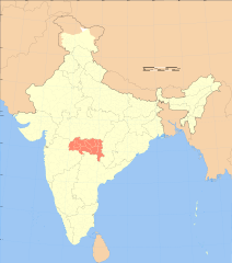
1376:
612:
390:
1004:
960:
916:
781:
495:
166:
1146:
805:
is almost entirely claimed by China as part of its
Tibetan territory.
613:
601:
149:
1123:
1083:
1032:
Click on a date/time to view the file as it appeared at that time.
784:). Since 1972, it is divided between all three countries. See also
1090:
with district boundaries. |Source=. |Date=September 2006 |Author=
721:
Please check local laws and modify the map accordingly before use.
208:
197:
1113:
240:
738:
153:
816:
For a detailed map of all disputed regions in South Asia, see
1087:
236:
82:(SVG file, nominally 1,639 × 1,852 pixels, file size: 795 KB)
88:
772:
The northern
Himalayan region of the disputed territory
857:
Add a one-line explanation of what this file represents
645:
586:
If inappropriate please set warp_status = skip to hide.
412:
179:
1256:
1216:
1206:
1186:
1176:
1102:
726:
1386:
1137:
1030:
967:
Creative Commons Attribution-ShareAlike 3.0 Unported
941:
Creative Commons Attribution-ShareAlike 3.0 Unported
112:
Commons is a freely licensed media file repository.
572:
161:
596:
130:
635:
420:
404:
1392:User:Daniel Mietchen/Wikidata lists/India/Places
655:
694:
1119:Proposed states and union territories of India
763:
371:https://creativecommons.org/licenses/by-sa/3.0
93:
377:Creative Commons Attribution-Share Alike 3.0
301:
280:
175:
140:
268:
185:
14:
337:– to copy, distribute and transmit the work
41:Size of this PNG preview of this SVG file:
127:
1139:The following other wikis use this file:
780:) and the Chinese-occupied territory of (
619:
408:second half of 20 century and 21 century
706:) and the National Geographic Society (
675:
580:Georeference the map in Wikimaps Warper
831:
665:
124:
324:Attribution-Share Alike 3.0 Unported
1023:
823:
312:
307:
13:
870:
864:
856:
818:Image:India disputed areas map.svg
737:
730:
727:Explanation of disputed boundaries
650:Explanation of disputed boundaries
614:
298:
294:
165:
125:
75:
1405:
869:
615:
1103:
847:
753:Line of Control/Line of Conflict
494:
389:
348:Under the following conditions:
319:This file is licensed under the
311:
306:
300:
92:
31:
21:
844:
776:is claimed by India including (
209:University of Texas map library
198:University of Texas map library
1134:
1027:
843:
801:The northeastern territory of
234:State and District boundaries:
143:India Vidarbha locator map.svg
26:
1:
1011:original creation by uploader
985:original creation by uploader
778:Pakistan-administered Kashmir
578:
148:Locator map of the region of
1099:
877:Items portrayed in this file
695:Depiction of India's borders
640:Depiction of India's borders
258:Survey of India Map Explorer
7:
1283:Usage on mai.wikipedia.org
774:Indian-administered Kashmir
764:Borders of disputed regions
660:Borders of disputed regions
10:
1410:
1383:Usage on www.wikidata.org
1373:Usage on ur.wikipedia.org
1363:Usage on uk.wikipedia.org
1353:Usage on te.wikipedia.org
1343:Usage on ta.wikipedia.org
1328:Usage on ru.wikipedia.org
1318:Usage on ne.wikipedia.org
1303:Usage on mr.wikipedia.org
1293:Usage on ml.wikipedia.org
1273:Usage on kn.wikipedia.org
1263:Usage on ja.wikipedia.org
1253:Usage on it.wikipedia.org
1243:Usage on hi.wikipedia.org
1233:Usage on gu.wikipedia.org
1223:Usage on fa.wikipedia.org
1213:Usage on eu.wikipedia.org
1203:Usage on es.wikipedia.org
1193:Usage on el.wikipedia.org
1183:Usage on de.wikipedia.org
1173:Usage on ca.wikipedia.org
1163:Usage on bn.wikipedia.org
1153:Usage on as.wikipedia.org
1143:Usage on ar.wikipedia.org
625:
424:
362:same or compatible license
1312:स्वतंत्र विदर्भराज्य चळवळ
1024:
591:
399:
190:
156:with district boundaries.
16:
865:भारताच्या नकाशावर विदर्भ
846:
747:Boundary of Indian claim
689:
413:Spatial reference system
328:
202:India Political map 2001
99:This is a file from the
36:
1081:
1060:16:40, 4 September 2006
103:. Information from its
840:for more information.
790:Line of Actual Control
742:
735:
602:WikiProject India Maps
400: Geotemporal data
241:2001 Census State Maps
195:International Borders:
170:
106:description page there
1337:Возможные штаты Индии
741:
734:
169:
1109:2020 Vidarbha floods
1094:|Thumbdir=CHANGE }}
245:Survey of India Maps
135:Vidarbha locator map
69:1,639 × 1,852 pixels
65:1,812 × 2,048 pixels
592: Archival data
343:– to adapt the work
262:Columbia University
254:US Army Map Service
225:Kashmir Region 2004
221:Western Sector 1988
217:Eastern Sector 1988
213:China-India Borders
47:Other resolutions:
832:Territorial waters
743:
736:
680:Territorial waters
171:
61:906 × 1,024 pixels
1135:Global file usage
1129:Vidarbha movement
1097:
951:copyright license
937:copyright license
863:
855:
803:Arunachal Pradesh
620:
607:
606:
587:
568:
567:
289:
286:Reusing this file
206:Disputed Borders:
121:
120:
101:Wikimedia Commons
32:Global file usage
1401:
1072:
1034:
907:copyright status
893:copyright status
861:
853:
824:Internal borders
681:
678:
671:
670:Internal borders
668:
661:
658:
651:
648:
641:
638:
631:
628:
621:
585:
584:
582:
581:
564:
562:
561:
560:
555:
551:
550:
547:
546:
543:
532:
530:
529:
528:
523:
519:
518:
515:
514:
511:
498:
487:
485:
484:
483:
478:
477:38.57°N 100.05°E
474:
473:
470:
469:
466:
455:
453:
452:
451:
446:
442:
441:
438:
437:
434:
425:
393:
384:
381:
378:
375:
372:
364:as the original.
321:Creative Commons
315:
314:
310:
309:
304:
303:
283:
192:
181:
144:
128:
117:
96:
95:
89:
83:
72:
57:680 × 768 pixels
53:425 × 480 pixels
49:212 × 240 pixels
43:530 × 599 pixels
1409:
1408:
1404:
1403:
1402:
1400:
1399:
1398:
1133:
1105:
1098:
1092:w:user:Planemad
1078:
1070:
1026:
1025:
1022:
1021:
1020:
1019:
1018:
1017:
1016:
1015:
1013:
1001:
1000:
999:
997:
978:
977:
976:
975:
974:
973:
972:
971:
969:
957:
956:
955:
953:
934:
933:
932:
931:
930:
929:
928:
927:
925:
913:
912:
911:
909:
890:
889:
888:
887:
886:
884:
868:
867:
866:
859:
858:
834:
826:
796:Siachen glacier
786:Line of Control
766:
729:
697:
692:
687:
679:
676:
669:
666:
659:
656:
649:
646:
639:
636:
629:
626:
622:
618:
608:
579:
576:
558:
556:
552:
548:
544:
541:
539:
537:
526:
524:
520:
516:
512:
509:
507:
505:
481:
479:
475:
471:
467:
464:
462:
460:
449:
447:
445:38.06°N 64.21°E
443:
439:
435:
432:
430:
428:
387:
386:
385:
382:
379:
376:
373:
370:
369:
327:
316:
297:
296:
276:
274:w:user:Planemad
237:Census of India
157:
142:
136:
123:
122:
111:
110:
109:is shown below.
85:
81:
74:
73:
46:
12:
11:
5:
1407:
1397:
1396:
1395:
1394:
1389:
1381:
1380:
1379:
1371:
1370:
1369:
1361:
1360:
1359:
1351:
1350:
1349:
1341:
1340:
1339:
1334:
1326:
1325:
1324:
1316:
1315:
1314:
1309:
1301:
1300:
1299:
1291:
1290:
1289:
1281:
1280:
1279:
1271:
1270:
1269:
1261:
1260:
1259:
1251:
1250:
1249:
1241:
1240:
1239:
1231:
1230:
1229:
1221:
1220:
1219:
1211:
1210:
1209:
1201:
1200:
1199:
1191:
1190:
1189:
1181:
1180:
1179:
1171:
1170:
1169:
1161:
1160:
1159:
1151:
1150:
1149:
1136:
1132:
1131:
1126:
1121:
1116:
1111:
1101:
1096:
1095:
1080:
1076:
1073:
1069:1,639 × 1,852
1067:
1062:
1057:
1053:
1052:
1049:
1046:
1043:
1040:
1037:
1029:
1014:
1009:
1007:
1006:
1005:
1003:
1002:
998:
995:source of file
993:
991:
990:
989:
988:
986:
982:
981:source of file
970:
965:
963:
962:
961:
959:
958:
954:
949:
947:
946:
945:
944:
942:
938:
926:
921:
919:
918:
917:
915:
914:
910:
905:
903:
902:
901:
900:
898:
894:
885:
880:
878:
875:
874:
873:
872:
860:
852:
851:
848:
845:
833:
830:
825:
822:
813:
812:
809:
806:
799:
793:
782:Ladakh plateau
765:
762:
761:
760:
750:
728:
725:
724:
723:
717:
716:verifiability.
713:
696:
693:
691:
688:
686:
685:
684:
683:
673:
663:
653:
643:
617:
605:
604:
598:
594:
593:
589:
588:
574:
573:Georeferencing
570:
569:
566:
565:
554:5.60°N 96.87°E
535:
533:
522:5.12°N 68.44°E
502:
501:
499:
492:
489:
488:
458:
456:
422:
418:
417:
414:
410:
409:
406:
402:
401:
397:
396:
368:
367:
366:
365:
355:
346:
345:
344:
338:
331:You are free:
318:
317:
299:
293:
292:
290:
278:
277:
272:
270:
266:
265:
251:Other sources:
187:
183:
182:
180:September 2006
177:
173:
172:
163:
159:
158:
147:
145:
138:
137:
134:
132:
126:
119:
118:
97:
87:
86:
40:
35:
34:
29:
24:
19:
9:
6:
4:
3:
2:
1406:
1393:
1390:
1388:
1385:
1384:
1382:
1378:
1375:
1374:
1372:
1368:
1365:
1364:
1362:
1358:
1355:
1354:
1352:
1348:
1345:
1344:
1342:
1338:
1335:
1333:
1330:
1329:
1327:
1323:
1320:
1319:
1317:
1313:
1310:
1308:
1305:
1304:
1302:
1298:
1295:
1294:
1292:
1288:
1285:
1284:
1282:
1278:
1275:
1274:
1272:
1268:
1265:
1264:
1262:
1258:
1255:
1254:
1252:
1248:
1245:
1244:
1242:
1238:
1235:
1234:
1232:
1228:
1225:
1224:
1222:
1218:
1215:
1214:
1212:
1208:
1205:
1204:
1202:
1198:
1195:
1194:
1192:
1188:
1185:
1184:
1182:
1178:
1175:
1174:
1172:
1168:
1165:
1164:
1162:
1158:
1155:
1154:
1152:
1148:
1145:
1144:
1142:
1141:
1140:
1130:
1127:
1125:
1122:
1120:
1117:
1115:
1112:
1110:
1107:
1106:
1093:
1089:
1085:
1079:
1074:
1068:
1066:
1063:
1061:
1058:
1055:
1054:
1050:
1047:
1044:
1041:
1038:
1036:
1035:
1033:
1012:
1008:
996:
992:
968:
964:
952:
948:
924:
920:
908:
904:
883:
879:
876:
849:
842:
841:
839:
829:
821:
820:
819:
810:
807:
804:
800:
797:
794:
791:
787:
783:
779:
775:
771:
770:
769:
758:
754:
751:
748:
745:
744:
740:
733:
722:
718:
714:
711:
708:
705:
702:
699:
698:
682:
674:
672:
664:
662:
654:
652:
644:
642:
634:
633:
632:
624:
623:
611:
610:
603:
599:
595:
590:
583:
575:
571:
563:
536:
534:
531:
504:
503:
500:
497:
493:
491:
490:
486:
482:38.57; 100.05
459:
457:
454:
427:
426:
423:
419:
415:
411:
407:
405:Date depicted
403:
398:
392:
388:
374:CC BY-SA 3.0
363:
359:
356:
353:
350:
349:
347:
342:
339:
336:
333:
332:
330:
329:
325:
322:
305:
291:
287:
282:
279:
275:
271:
267:
264:
263:
259:
255:
252:
249:
248:
246:
242:
238:
235:
232:
230:
226:
222:
218:
214:
210:
207:
204:
203:
199:
196:
193:
188:
184:
178:
174:
168:
164:
160:
155:
151:
146:
139:
133:
129:
115:
108:
107:
102:
98:
91:
90:
84:
79:
78:Original file
70:
66:
62:
58:
54:
50:
44:
39:
33:
30:
28:
25:
23:
20:
18:
15:
1138:
1031:
1028:File history
835:
827:
815:
814:
767:
756:
755: : The
752:
746:
720:
609:
450:38.06; 64.21
421:Bounding box
357:
351:
340:
334:
250:
233:
229:Kashmir Maps
205:
194:
189:
114:You can help
104:
76:
22:File history
923:copyrighted
897:copyrighted
559:5.60; 96.87
527:5.12; 68.44
358:share alike
352:attribution
141:Description
1227:برار (هند)
1100:File usage
1045:Dimensions
281:Permission
162:Map legend
27:File usage
1197:Βιντάρμπα
1042:Thumbnail
1039:Date/Time
1367:Відарбга
1332:Видарбха
1257:Vidarbha
1217:Vidarbha
1207:Vidarbha
1187:Vidarbha
1177:Vidarbha
1124:Vidarbha
1084:Vidarbha
1077:Planemad
1071:(795 KB)
850:Captions
757:de facto
616:Contents
600:Part of
468:100°03′E
341:to remix
335:to share
326:license.
191:Own work
150:Vidarbha
1387:Q568561
1347:விதர்பா
1114:Magadha
1056:current
1051:Comment
882:depicts
862:Marathi
854:English
545:96°52′E
513:68°26′E
465:38°34′N
436:64°13′E
433:38°04′N
269:Creator
80:
1357:విదర్భ
1322:विदर्भ
1307:विदर्भ
1287:विदर्भ
1277:ವಿದರ್ಭ
1247:विदर्भ
1237:વિદર્ભ
1167:বিদর্ভ
1157:বিদৰ্ভ
542:5°36′N
510:5°07′N
395:usage.
219:&
186:Source
1377:ودربھ
1297:വിദർഭ
1267:ヴィダルバ
1088:India
690:Notes
630:Notes
597:Notes
416:conic
154:India
131:Title
1147:برار
1048:User
838:this
788:and
383:true
380:true
176:Date
17:File
677:1.5
667:1.4
657:1.3
647:1.2
637:1.1
549:/
517:/
472:/
440:/
1086:,
709:,
703:,
557:/
525:/
480:/
448:/
260:,
256:,
243:-
239:-
227:-
223:-
215:-
211:-
200:-
152:,
67:|
63:|
59:|
55:|
51:|
45:.
792:.
712:)
627:1
288:)
284:(
247:.
231:.
116:.
71:.
Text is available under the Creative Commons Attribution-ShareAlike License. Additional terms may apply.

