38:
361:
828:
450:
555:
683:
367:
372:
835:
94:
1123:"}},"text\/plain":{"en":{"":"media type"}}},"{\"value\":\"image\\\/svg+xml\",\"type\":\"string\"}":{"text\/html":{"en":{"P1163":"image\/svg+xml"}},"text\/plain":{"en":{"P1163":"image\/svg+xml"}}}}": -->
1035:"}},"text\/plain":{"en":{"":"copyright license"}}},"{\"value\":{\"entity-type\":\"item\",\"numeric-id\":14946043,\"id\":\"Q14946043\"},\"type\":\"wikibase-entityid\"}":{"text\/html":{"en":{"P275":"
991:"}},"text\/plain":{"en":{"":"copyright status"}}},"{\"value\":{\"entity-type\":\"item\",\"numeric-id\":50423863,\"id\":\"Q50423863\"},\"type\":\"wikibase-entityid\"}":{"text\/html":{"en":{"P6216":"
1079:"}},"text\/plain":{"en":{"":"source of file"}}},"{\"value\":{\"entity-type\":\"item\",\"numeric-id\":66458942,\"id\":\"Q66458942\"},\"type\":\"wikibase-entityid\"}":{"text\/html":{"en":{"P7482":"
1119:
1199:
453:
The frontiers depicted on the Indian maps in
Knowledge are from a neutral point of view and may differ from official government maps of India, Pakistan and China. Please consult local laws governing publication of maps before
413:– You must give appropriate credit, provide a link to the license, and indicate if changes were made. You may do so in any reasonable manner, but not in any way that suggests the licensor endorses you or your use.
811:
This map is meant to be for illustrative purpose only and is not authenticated by official government sources. Please check the list of sources and references used to create the map for a measure of accuracy and
855:
administrative boundary recognised by the international community. This UN ceasefire line is considered as a temporary solution to an ongoing conflict since the departure of the
British Raj.
864:
The depicted extent of the former territory of the
British Indian Empire, succeeded by Republic of India, may not be accepted by few countries as legal due to ongoing border disputes:
815:
The usage of these maps in India, Pakistan and China are governed by different laws that restrict depictions of boundaries other than what is officially recognized by the state.
924:
The borders of the state of
Meghalaya, Assam and Arunachal Pradesh are shown as interpreted from the North-Eastern Areas (Reorganisation) Act, 1971, but has yet to be verified.
1080:
1036:
992:
1724:
166:
1889:
1120:
1076:
988:
904:
Minor areas of eastern
Kashmir's Ladakh division, Himachal Pradesh and Uttarakhand on the Chinese frontier are claimed by China. These areas are under Indian control.
1032:
1869:
796:
The territorial boundaries of India are shown as per the actual ground situation in accordance with international practices followed by the United
Nations (
1834:
1829:
2003:
1879:
1501:
68:
64:
1526:
1039:"}},"text\/plain":{"en":{"P275":"Creative Commons Attribution-ShareAlike 3.0 Unported"}}}}": -->
60:
56:
52:
48:
42:
803:
1496:
286:
1859:
314:
and include a link to this page. No explicit permission is needed from me, but id appreciate an email if my work has been of help to you.
1676:
1511:
800:
344:
105:
1661:
1486:
77:
597:
520:
488:
565:
1461:
1106:
1062:
1018:
1949:
1919:
1521:
1476:
1456:
420:
932:
The limit of the territorial waters of India extends to twelve nautical miles measured from the appropriate baseline. See
894:(shown white) is an actively contested region between India and Pakistan. Since 1984, the region is under Indian control.
1228:
1223:
1130:
1090:
1002:
1636:
1481:
1471:
1466:
1083:"}},"text\/plain":{"en":{"P7482":"original creation by uploader"}}}}": -->
913:
1046:
977:
1974:
1909:
1894:
1884:
1666:
1576:
1646:
1491:
907:
A small area of
Uttarakhand adjoining the Nepal border along the Sarda river is disputed between the two countries.
218:
1671:
1586:
222:
1451:
214:
1656:
1631:
1596:
382:
226:
1571:
1506:
1989:
1969:
1964:
1914:
1641:
1616:
1606:
1556:
869:
1824:
1581:
1541:
1516:
419:– If you remix, transform, or build upon the material, you must distribute your contributions under the
1651:
1626:
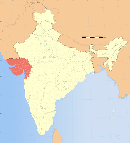
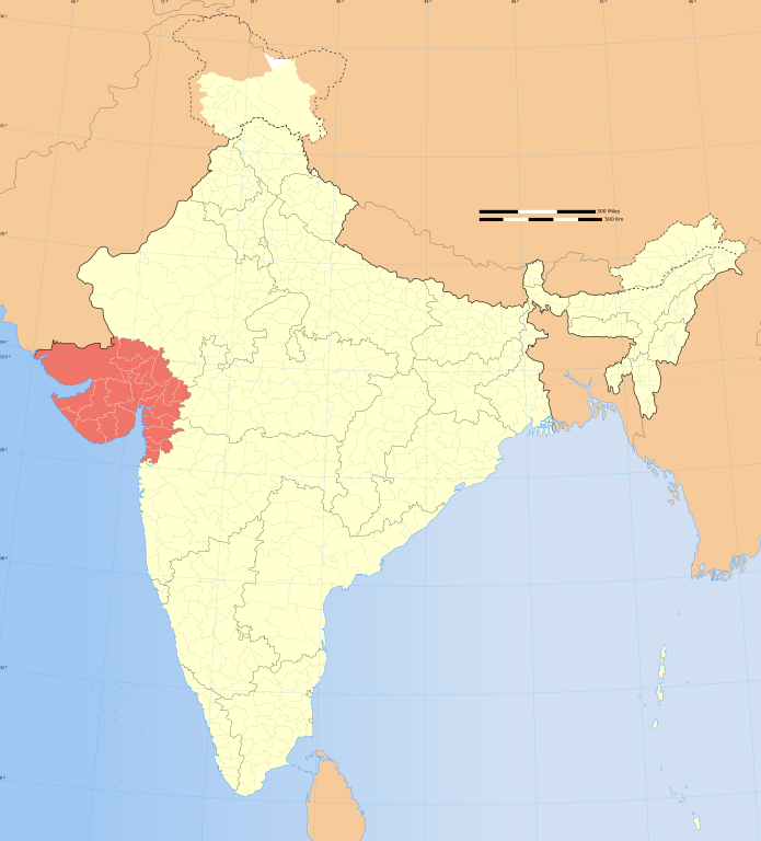
1591:
1566:
1531:
1799:
1246:{{WikiProject_India_Maps |Title=Gujarat locator map |Description=Locator map of the state of Gujarat,
845: : The territory India claims is legally theirs, but the claim is disputed by China and Pakistan.
203:
1341:
995:"}},"text\/plain":{"en":{"P6216":"copyrighted"}}}}": -->
1267:
The following pages on the
English Knowledge use this file (pages on other projects are not listed):
1939:
1904:
1874:
1849:
1844:
1754:
1744:
1714:
1704:
1611:
1601:
1551:
1546:
258:
1536:
885:
113:
1621:
1561:
1366:
1281:
1198:
1193:
37:
797:
1734:
1346:
933:
1316:
379:
262:
1994:
1984:
1954:
1944:
1924:
1899:
1794:
317:
If you dont want to release your work under a creative commons license, please mail me at
8:
1431:
1381:
1326:
1286:
1809:
1446:
1321:
1276:
1271:
898:
682:
1391:
1361:
1336:
1311:
1216:{{Information |Description= |Source= |Date= |Author= |Permission= |other_versions= }}
100:
967:
354:
I, the copyright holder of this work, hereby publish it under the following license:
1411:
1406:
1401:
1371:
1331:
891:
881:
636:
307:
1959:
1934:
1929:
1864:
1819:
1814:
1804:
1441:
1426:
1376:
296:
1396:
1296:
1291:
246:
806:
230:
1351:
1301:
1254:
1239:
1209:
873:
827:
701:
612:
599:
580:
567:
535:
522:
503:
490:
319:
254:
1421:
1306:
1251:
708:
449:
1436:
1386:
1356:
1140:
1100:
1056:
1012:
877:
1979:
1854:
554:
1416:
901:
is almost entirely claimed by China as part of its
Tibetan territory.
709:
668:
324:
1784:
1166:
Click on a date/time to view the file as it appeared at that time.
880:). Since 1972, it is divided between all three countries. See also
149:
817:
Please check local laws and modify the map accordingly before use.
210:
199:
1250:
with district boundaries. |Source=. |Date=August 6 2006 |Author=
242:
834:
153:
912:
For a detailed map of all disputed regions in South Asia, see
1247:
238:
82:(SVG file, nominally 1,574 × 1,738 pixels, file size: 836 KB)
181:
88:
868:
The northern
Himalayan region of the disputed territory
953:
Add a one-line explanation of what this file represents
741:
645:
If inappropriate please set warp_status = skip to hide.
471:
1694:
1774:
1265:
822:
1764:
1685:
1164:
1063:
Creative Commons Attribution-ShareAlike 3.0 Unported
1037:
Creative Commons Attribution-ShareAlike 3.0 Unported
112:
Commons is a freely licensed media file repository.
655:
631:
161:
663:
130:
731:
479:
463:
1502:Knowledge:Userboxes/WikiProjects/alphabetical/12
751:
328:to negotiate a custom license as per your needs.
790:
859:
430:https://creativecommons.org/licenses/by-sa/3.0
93:
1527:Knowledge:WikiProject India/userbox templates
436:Creative Commons Attribution-Share Alike 3.0
360:
339:
177:
140:
1497:Knowledge:Userboxes/WikiProjects/Regional/04
674:
274:
187:
14:
396:– to copy, distribute and transmit the work
165:
41:Size of this PNG preview of this SVG file:
1677:Category:Wikipedians interested in Gujarat
1512:Knowledge:WikiProject Gujarat/Participants
127:
1687:The following other wikis use this file:
1662:Category:WikiProject Gujarat participants
1487:Knowledge:Userboxes/Location/India/States
876:) and the Chinese-occupied territory of (
715:
467:second half of 20 century and 21 century
1462:Knowledge:Userboxes/Life/Citizenship/04
802:) and the National Geographic Society (
771:
639:Georeference the map in Wikimaps Warper
168:File:India map legdbsbsbsgsbend en.png
1522:Knowledge:WikiProject India/Templates
1477:Knowledge:Userboxes/Life/Residence/04
927:
761:
306:If you are using the image under the
124:
1457:Knowledge:Userboxes/Life/Ancestry/06
383:Attribution-Share Alike 3.0 Unported
308:creative commons share alike license
1157:
919:
371:
366:
13:
1637:Template:User interest Gujarat/doc
1482:Knowledge:Userboxes/Location/India
1472:Knowledge:Userboxes/Life/Origin/04
1467:Knowledge:Userboxes/Life/Ethnicity
966:
960:
952:
914:Image:India disputed areas map.svg
833:
826:
823:Explanation of disputed boundaries
746:Explanation of disputed boundaries
710:
357:
353:
125:
75:
2015:
1667:Category:Wikipedians from Gujarat
1577:Template:User citizen Gujarat/doc
965:
711:
1647:Template:User interest India/doc
1492:Knowledge:Userboxes/Travel/India
1266:
943:
849:Line of Control/Line of Conflict
681:
553:
448:
407:Under the following conditions:
378:This file is licensed under the
370:
365:
359:
279:
92:
31:
21:
1672:Category:Wikipedians in Gujarat
1587:Template:User citizen India/doc
940:
872:is claimed by India including (
211:University of Texas map library
200:University of Texas map library
1682:
1657:Template:User proud Indian/doc
1632:Template:User interest Gujarat
1597:Template:User from Gujarat/doc
1161:
939:
897:The northeastern territory of
236:State and District boundaries:
26:
1:
1572:Template:User citizen Gujarat
1507:Knowledge:WikiProject Gujarat
1107:original creation by uploader
1081:original creation by uploader
874:Pakistan-administered Kashmir
659:રખે ઠાકોર 21 કિલોમી ઠાકોર નથી
637:
143:India Gujarat locator map.svg
1642:Template:User interest India
1617:Template:User in Gujarat/doc
1607:Template:User from India/doc
1557:Template:User WP Gujarat/doc
1262:
973:Items portrayed in this file
791:Depiction of India's borders
736:Depiction of India's borders
282:
259:Survey of India Map Explorer
148:Locator map of the state of
7:
1781:Usage on ceb.wikipedia.org
1771:Usage on cdo.wikipedia.org
1691:Usage on ang.wikipedia.org
1582:Template:User citizen India
1542:Template:User IN states/doc
1517:Knowledge:WikiProject India
870:Indian-administered Kashmir
860:Borders of disputed regions
756:Borders of disputed regions
312:CC-by-sa PlaneMad/Wikimedia
10:
2020:
1841:Usage on gu.wikipedia.org
1791:Usage on fa.wikipedia.org
1761:Usage on br.wikipedia.org
1751:Usage on bn.wikipedia.org
1741:Usage on bh.wikipedia.org
1731:Usage on bg.wikipedia.org
1721:Usage on be.wikipedia.org
1711:Usage on ba.wikipedia.org
1701:Usage on as.wikipedia.org
1652:Template:User proud Indian
1627:Template:User in India/doc
1592:Template:User from Gujarat
1567:Template:User WP India/doc
1532:Template:User Gujarat/doc1
721:
483:
421:same or compatible license
1342:User:GujaratiHistoryinDNA
1158:
650:
458:
192:
156:with district boundaries.
16:
1612:Template:User in Gujarat
1602:Template:User from India
1552:Template:User WP Gujarat
1547:Template:User India/doc1
942:
843:Boundary of Indian claim
785:
704:: unknown parameter "1".
472:Spatial reference system
387:
310:please credit the photo
204:India Political map 2001
99:This is a file from the
36:
1725:Штаты і тэрыторыі Індыі
1537:Template:User IN states
1245:
1215:
1194:06:45, 29 December 2008
103:. Information from its
1622:Template:User in India
1562:Template:User WP India
1367:User:Mahesh Chhanga 78
1282:User:Ageo020/Userboxes
936:for more information.
886:Line of Actual Control
838:
831:
669:WikiProject India Maps
459: Geotemporal data
243:2001 Census State Maps
197:International Borders:
172:
106:description page there
1347:User:Hardyisback11188
837:
830:
268:Map specific sources:
171:
1317:User:Chariotrider555
1224:17:34, 6 August 2006
247:Survey of India Maps
69:1,574 × 1,738 pixels
65:1,855 × 2,048 pixels
1835:شورشهای ۱۹۸۵ گجرات
1830:شورشهای ۱۹۶۹ گجرات
1432:User:Suhebriazsaifi
1382:User:Manseta.devang
1327:User:Devansu rathod
1287:User:Akshay Das UTW
1257:|Thumbdir=CHANGE }}
651: Archival data
402:– to adapt the work
263:Columbia University
255:US Army Map Service
227:Kashmir Region 2004
223:Western Sector 1988
219:Eastern Sector 1988
215:China-India Borders
135:Gujarat locator map
47:Other resolutions:
1890:ભાત (તા. દસ્ક્રોઇ)
1447:User:WikiEdits2003
1322:User:ChautanRadhan
1277:1985 Gujarat riots
1272:1969 Gujarat riots
928:Territorial waters
839:
832:
776:Territorial waters
322:or catch me at my
173:
61:927 × 1,024 pixels
2004:more global usage
1683:Global file usage
1392:User:Nishantgohil
1362:User:KartikMistry
1337:User:GauravVDesai
1312:User:Buaidh/Test7
1260:
1047:copyright license
1033:copyright license
959:
951:
899:Arunachal Pradesh
716:
695:
694:
646:
627:
626:
348:
345:Reusing this file
334:
333:
208:Disputed Borders:
121:
120:
101:Wikimedia Commons
32:Global file usage
2011:
1880:ચલાલા (તા. ધારી)
1870:હાથબ (તા.ભાવનગર)
1785:State of Gujarāt
1412:User:Rillrilling
1407:User:Rahilarious
1402:User:Piyakapadia
1372:User:Mananshah15
1332:User:Dudhatjanak
1236:
1206:
1168:
1003:copyright status
989:copyright status
957:
949:
920:Internal borders
777:
774:
767:
766:Internal borders
764:
757:
754:
747:
744:
737:
734:
727:
724:
717:
705:
702:{{Map}} template
685:
644:
643:
641:
640:
623:
621:
620:
619:
614:
610:
609:
606:
605:
602:
591:
589:
588:
587:
582:
578:
577:
574:
573:
570:
557:
546:
544:
543:
542:
537:
533:
532:
529:
528:
525:
514:
512:
511:
510:
505:
501:
500:
497:
496:
493:
484:
452:
443:
440:
437:
434:
431:
423:as the original.
380:Creative Commons
374:
373:
369:
368:
363:
362:
342:
280:
194:
183:
182:29 December 2008
169:
144:
128:
117:
96:
95:
89:
83:
72:
57:695 × 768 pixels
53:435 × 480 pixels
49:217 × 240 pixels
43:543 × 600 pixels
2019:
2018:
2014:
2013:
2012:
2010:
2009:
2008:
1681:
1442:User:Vinitp2004
1427:User:SpunkyGeek
1377:User:Mangomasti
1268:
1261:
1255:w:user:Planemad
1242:
1234:
1212:
1204:
1160:
1159:
1156:
1155:
1154:
1153:
1152:
1151:
1150:
1149:
1147:
1137:
1136:
1135:
1133:
1118:
1117:
1116:
1115:
1114:
1113:
1112:
1111:
1109:
1097:
1096:
1095:
1093:
1074:
1073:
1072:
1071:
1070:
1069:
1068:
1067:
1065:
1053:
1052:
1051:
1049:
1030:
1029:
1028:
1027:
1026:
1025:
1024:
1023:
1021:
1009:
1008:
1007:
1005:
986:
985:
984:
983:
982:
980:
964:
963:
962:
955:
954:
930:
922:
892:Siachen glacier
882:Line of Control
862:
825:
793:
788:
783:
775:
772:
765:
762:
755:
752:
745:
742:
735:
732:
725:
722:
718:
714:
699:
696:
689:
686:
638:
635:
617:
615:
611:
607:
603:
600:
598:
596:
585:
583:
579:
575:
571:
568:
566:
564:
540:
538:
534:
530:
526:
523:
521:
519:
508:
506:
502:
498:
494:
491:
489:
487:
446:
445:
444:
441:
438:
435:
432:
429:
428:
386:
375:
356:
355:
335:
239:Census of India
167:
157:
142:
136:
123:
122:
111:
110:
109:is shown below.
85:
81:
74:
73:
46:
12:
11:
5:
2017:
2006:of this file.
2000:
1999:
1998:
1997:
1992:
1987:
1982:
1977:
1972:
1967:
1962:
1957:
1952:
1947:
1942:
1937:
1932:
1927:
1922:
1917:
1912:
1907:
1902:
1897:
1892:
1887:
1882:
1877:
1872:
1867:
1862:
1857:
1852:
1847:
1839:
1838:
1837:
1832:
1827:
1822:
1817:
1812:
1807:
1802:
1797:
1789:
1788:
1787:
1779:
1778:
1777:
1769:
1768:
1767:
1759:
1758:
1757:
1749:
1748:
1747:
1739:
1738:
1737:
1729:
1728:
1727:
1719:
1718:
1717:
1709:
1708:
1707:
1699:
1698:
1697:
1684:
1680:
1679:
1674:
1669:
1664:
1659:
1654:
1649:
1644:
1639:
1634:
1629:
1624:
1619:
1614:
1609:
1604:
1599:
1594:
1589:
1584:
1579:
1574:
1569:
1564:
1559:
1554:
1549:
1544:
1539:
1534:
1529:
1524:
1519:
1514:
1509:
1504:
1499:
1494:
1489:
1484:
1479:
1474:
1469:
1464:
1459:
1454:
1449:
1444:
1439:
1434:
1429:
1424:
1419:
1414:
1409:
1404:
1399:
1397:User:Njoy deep
1394:
1389:
1384:
1379:
1374:
1369:
1364:
1359:
1354:
1349:
1344:
1339:
1334:
1329:
1324:
1319:
1314:
1309:
1304:
1299:
1297:User:Ambaputra
1294:
1292:User:Amadavadi
1289:
1284:
1279:
1274:
1264:
1259:
1258:
1252:w:user:Nichalp
1244:
1240:
1237:
1233:1,639 × 1,852
1231:
1226:
1221:
1218:
1217:
1214:
1210:
1207:
1203:1,574 × 1,738
1201:
1196:
1191:
1187:
1186:
1183:
1180:
1177:
1174:
1171:
1163:
1148:
1145:
1143:
1142:
1141:
1139:
1138:
1134:
1129:
1127:
1126:
1125:
1124:
1122:
1110:
1105:
1103:
1102:
1101:
1099:
1098:
1094:
1091:source of file
1089:
1087:
1086:
1085:
1084:
1082:
1078:
1077:source of file
1066:
1061:
1059:
1058:
1057:
1055:
1054:
1050:
1045:
1043:
1042:
1041:
1040:
1038:
1034:
1022:
1017:
1015:
1014:
1013:
1011:
1010:
1006:
1001:
999:
998:
997:
996:
994:
990:
981:
976:
974:
971:
970:
969:
968:
961:ઇન્ડિયા ગુજરાત
956:
948:
947:
944:
941:
929:
926:
921:
918:
909:
908:
905:
902:
895:
889:
878:Ladakh plateau
861:
858:
857:
856:
846:
824:
821:
820:
819:
813:
812:verifiability.
809:
792:
789:
787:
784:
782:
781:
780:
779:
769:
759:
749:
739:
713:
707:
706:
693:
692:
691:
690:
687:
680:
676:
675:Other versions
672:
671:
665:
661:
660:
657:
653:
652:
648:
647:
633:
632:Georeferencing
629:
628:
625:
624:
613:6.25°N 96.09°E
594:
592:
561:
560:
558:
551:
548:
547:
536:37.23°N 99.0°E
517:
515:
504:36.70°N 64.8°E
481:
477:
476:
473:
469:
468:
465:
461:
460:
456:
455:
427:
426:
425:
424:
414:
405:
404:
403:
397:
390:You are free:
377:
376:
358:
352:
351:
349:
337:
336:
332:
331:
330:
329:
315:
292:was created by
283:
278:
276:
272:
271:
252:Other sources:
189:
185:
184:
179:
175:
174:
163:
159:
158:
147:
145:
138:
137:
134:
132:
126:
119:
118:
97:
87:
86:
40:
35:
34:
29:
24:
19:
9:
6:
4:
3:
2:
2016:
2007:
2005:
1996:
1993:
1991:
1988:
1986:
1983:
1981:
1978:
1976:
1973:
1971:
1968:
1966:
1963:
1961:
1958:
1956:
1953:
1951:
1948:
1946:
1943:
1941:
1938:
1936:
1933:
1931:
1928:
1926:
1923:
1921:
1918:
1916:
1913:
1911:
1908:
1906:
1903:
1901:
1898:
1896:
1893:
1891:
1888:
1886:
1883:
1881:
1878:
1876:
1873:
1871:
1868:
1866:
1863:
1861:
1860:માંડવી (કચ્છ)
1858:
1856:
1853:
1851:
1848:
1846:
1843:
1842:
1840:
1836:
1833:
1831:
1828:
1826:
1823:
1821:
1818:
1816:
1813:
1811:
1808:
1806:
1803:
1801:
1798:
1796:
1793:
1792:
1790:
1786:
1783:
1782:
1780:
1776:
1773:
1772:
1770:
1766:
1763:
1762:
1760:
1756:
1753:
1752:
1750:
1746:
1743:
1742:
1740:
1736:
1733:
1732:
1730:
1726:
1723:
1722:
1720:
1716:
1713:
1712:
1710:
1706:
1703:
1702:
1700:
1696:
1693:
1692:
1690:
1689:
1688:
1678:
1675:
1673:
1670:
1668:
1665:
1663:
1660:
1658:
1655:
1653:
1650:
1648:
1645:
1643:
1640:
1638:
1635:
1633:
1630:
1628:
1625:
1623:
1620:
1618:
1615:
1613:
1610:
1608:
1605:
1603:
1600:
1598:
1595:
1593:
1590:
1588:
1585:
1583:
1580:
1578:
1575:
1573:
1570:
1568:
1565:
1563:
1560:
1558:
1555:
1553:
1550:
1548:
1545:
1543:
1540:
1538:
1535:
1533:
1530:
1528:
1525:
1523:
1520:
1518:
1515:
1513:
1510:
1508:
1505:
1503:
1500:
1498:
1495:
1493:
1490:
1488:
1485:
1483:
1480:
1478:
1475:
1473:
1470:
1468:
1465:
1463:
1460:
1458:
1455:
1453:
1452:User:Арія Шах
1450:
1448:
1445:
1443:
1440:
1438:
1435:
1433:
1430:
1428:
1425:
1423:
1420:
1418:
1415:
1413:
1410:
1408:
1405:
1403:
1400:
1398:
1395:
1393:
1390:
1388:
1385:
1383:
1380:
1378:
1375:
1373:
1370:
1368:
1365:
1363:
1360:
1358:
1355:
1353:
1352:User:Harsh182
1350:
1348:
1345:
1343:
1340:
1338:
1335:
1333:
1330:
1328:
1325:
1323:
1320:
1318:
1315:
1313:
1310:
1308:
1305:
1303:
1302:User:Ashvin29
1300:
1298:
1295:
1293:
1290:
1288:
1285:
1283:
1280:
1278:
1275:
1273:
1270:
1269:
1256:
1253:
1249:
1243:
1238:
1232:
1230:
1227:
1225:
1222:
1220:
1219:
1213:
1208:
1202:
1200:
1197:
1195:
1192:
1189:
1188:
1184:
1181:
1178:
1175:
1172:
1170:
1169:
1167:
1146:image/svg+xml
1144:
1132:
1128:
1108:
1104:
1092:
1088:
1064:
1060:
1048:
1044:
1020:
1016:
1004:
1000:
979:
975:
972:
945:
938:
937:
935:
925:
917:
916:
915:
906:
903:
900:
896:
893:
890:
887:
883:
879:
875:
871:
867:
866:
865:
854:
850:
847:
844:
841:
840:
836:
829:
818:
814:
810:
807:
804:
801:
798:
795:
794:
778:
770:
768:
760:
758:
750:
748:
740:
738:
730:
729:
728:
720:
719:
703:
698:
697:
684:
679:
678:
677:
673:
670:
666:
662:
658:
654:
649:
642:
634:
630:
622:
595:
593:
590:
581:5.9°N 68.76°E
563:
562:
559:
556:
552:
550:
549:
545:
518:
516:
513:
486:
485:
482:
478:
474:
470:
466:
464:Date depicted
462:
457:
451:
447:
433:CC BY-SA 3.0
422:
418:
415:
412:
409:
408:
406:
401:
398:
395:
392:
391:
389:
388:
384:
381:
364:
350:
346:
341:
338:
327:
326:
321:
320:
316:
313:
309:
305:
304:
303:
302:
299:
298:
297:User:PlaneMad
294:
293:
290:
289:
284:
281:
277:
273:
269:
266:
265:
264:
260:
256:
253:
250:
248:
244:
240:
237:
234:
232:
228:
224:
220:
216:
212:
209:
206:
205:
201:
198:
195:
190:
186:
180:
176:
170:
164:
160:
155:
151:
146:
139:
133:
129:
115:
108:
107:
102:
98:
91:
90:
84:
79:
78:Original file
70:
66:
62:
58:
54:
50:
44:
39:
33:
30:
28:
25:
23:
20:
18:
15:
2001:
1686:
1422:User:Sagavaj
1307:User:B.arjun
1165:
1162:File history
931:
923:
911:
910:
863:
852:
851: : The
848:
842:
816:
480:Bounding box
416:
410:
399:
393:
323:
318:
311:
300:
295:
291:
287:
285:
267:
251:
235:
231:Kashmir Maps
207:
196:
191:
114:You can help
104:
76:
22:File history
1437:User:TSAray
1387:User:Naraaz
1357:User:Het666
1019:copyrighted
993:copyrighted
618:6.25; 96.09
541:37.23; 99.0
509:36.70; 64.8
417:share alike
411:attribution
141:Description
1825:سورندرانگر
1263:File usage
1179:Dimensions
1131:media type
1121:media type
586:5.9; 68.76
340:Permission
288:This Image
162:Map legend
27:File usage
1950:વલ્લભીપુર
1920:કીડીયાનગર
1800:گاندینگر
1715:Һиндостан
1417:User:Rs7j
1176:Thumbnail
1173:Date/Time
700:Error in
688:blank map
1975:ગાંધીધામ
1910:મુન્દ્રા
1895:પાલીતાણા
1885:ગાંધીનગર
1735:Гуджарат
1695:Gucgerat
1241:Planemad
1235:(751 KB)
1211:Planemad
1205:(836 KB)
958:Gujarati
946:Captions
853:de facto
712:Contents
667:Part of
400:to remix
394:to share
385:license.
193:Own work
1990:મહેસાણા
1970:પીરમબેટ
1965:લોયાધામ
1915:પોરબંદર
1810:جوناگاد
1795:جامنگر
1775:Gujarat
1765:Gujarat
1190:current
1185:Comment
978:depicts
950:English
604:96°05′E
572:68°46′E
527:99°00′E
524:37°14′N
495:64°48′E
492:36°42′N
325:Website
275:Creator
150:Gujarat
80:
1940:મોઢેરા
1905:રાજકોટ
1875:જામનગર
1850:ભાવનગર
1845:વડોદરા
1820:راجکوت
1815:نادیاد
1805:باونگر
1755:গুজরাত
1745:गुजरात
1705:গুজৰাট
656:Medium
601:6°15′N
569:5°54′N
454:usage.
221:&
188:Source
2002:View
1995:અડાલજ
1985:વડનગર
1955:પાજોદ
1945:બોટાદ
1925:કરમસદ
1900:ઉનાવા
1248:India
786:Notes
726:Notes
664:Notes
475:conic
154:India
131:Title
1960:માતર
1935:ભરૂચ
1930:ગઢડા
1865:અલંગ
1182:User
934:this
884:and
442:true
439:true
178:Date
17:File
1980:કડી
1855:ભુજ
773:1.5
763:1.4
753:1.3
743:1.2
733:1.1
608:/
576:/
531:/
499:/
805:,
799:,
616:/
584:/
539:/
507:/
261:,
257:,
245:-
241:-
229:-
225:-
217:-
213:-
202:-
152:,
67:|
63:|
59:|
55:|
51:|
45:.
888:.
808:)
723:1
347:)
343:(
301:.
270:.
249:.
233:.
116:.
71:.
Text is available under the Creative Commons Attribution-ShareAlike License. Additional terms may apply.
