924:"}},"text\/plain":{"en":{"":"coordinates of the point of view"}}},"{\"value\":{\"latitude\":53.00115,\"longitude\":-1.5988,\"altitude\":null,\"precision\":1.0e-5,\"globe\":\"http:\\\/\\\/www.wikidata.org\\\/entity\\\/Q2\"},\"type\":\"globecoordinate\"}":{"text\/html":{"en":{"P1259":"53\u00b00'4.14"N, 1\u00b035'55.68"W"}},"text\/plain":{"en":{"P1259":"53\u00b00'4.14\"N, 1\u00b035'55.68\"W"}}},"{\"value\":{\"entity-type\":\"property\",\"numeric-id\":7787,\"id\":\"P7787\"},\"type\":\"wikibase-entityid\"}":{"text\/html":{"en":{"":"
992:"}},"text\/plain":{"en":{"":"coordinates of depicted place"}}},"{\"value\":{\"latitude\":53.00115,\"longitude\":-1.5986,\"altitude\":null,\"precision\":1.0e-5,\"globe\":\"http:\\\/\\\/www.wikidata.org\\\/entity\\\/Q2\"},\"type\":\"globecoordinate\"}":{"text\/html":{"en":{"P9149":"53\u00b00'4.14"N, 1\u00b035'54.96"W"}},"text\/plain":{"en":{"P9149":"53\u00b00'4.14\"N, 1\u00b035'54.96\"W"}}},"{\"value\":{\"entity-type\":\"property\",\"numeric-id\":7787,\"id\":\"P7787\"},\"type\":\"wikibase-entityid\"}":{"text\/html":{"en":{"":"
584:"}},"text\/plain":{"en":{"":"author name string"}}},"{\"value\":\"Rob Bradford\",\"type\":\"string\"}":{"text\/html":{"en":{"P2093":"Rob Bradford"}},"text\/plain":{"en":{"P2093":"Rob Bradford"}}},"{\"value\":{\"entity-type\":\"property\",\"numeric-id\":2699,\"id\":\"P2699\"},\"type\":\"wikibase-entityid\"}":{"text\/html":{"en":{"":"
886:"}},"text\/plain":{"en":{"":"inception"}}},"{\"value\":{\"time\":\"+2005-05-06T00:00:00Z\",\"timezone\":0,\"before\":0,\"after\":0,\"precision\":11,\"calendarmodel\":\"http:\\\/\\\/www.wikidata.org\\\/entity\\\/Q1985727\"},\"type\":\"time\"}":{"text\/html":{"en":{"P571":"6 May 2005"}},"text\/plain":{"en":{"P571":"6 May 2005"}}}}": -->
763:
568:
292:
334:
284:
988:
306:
377:
415:
420:
246:
198:
72:
771:"}},"text\/plain":{"en":{"P7482":"file available on the internet"}}},"{\"value\":{\"entity-type\":\"property\",\"numeric-id\":7384,\"id\":\"P7384\"},\"type\":\"wikibase-entityid\"}":{"text\/html":{"en":{"":"
576:"}},"text\/plain":{"en":{"":"object of statement has role"}}},"{\"value\":{\"entity-type\":\"item\",\"numeric-id\":33231,\"id\":\"Q33231\"},\"type\":\"wikibase-entityid\"}":{"text\/html":{"en":{"P3831":"
787:"}},"text\/plain":{"en":{"P137":"Geograph Britain and Ireland"}}},"{\"value\":{\"entity-type\":\"property\",\"numeric-id\":973,\"id\":\"P973\"},\"type\":\"wikibase-entityid\"}":{"text\/html":{"en":{"":"
1060:"}},"text\/plain":{"en":{"":"media type"}}},"{\"value\":\"image\\\/jpeg\",\"type\":\"string\"}":{"text\/html":{"en":{"P1163":"image\/jpeg"}},"text\/plain":{"en":{"P1163":"image\/jpeg"}}}}": -->
1098:"}},"text\/plain":{"en":{"":"location of creation"}}},"{\"value\":{\"entity-type\":\"item\",\"numeric-id\":615065,\"id\":\"Q615065\"},\"type\":\"wikibase-entityid\"}":{"text\/html":{"en":{"P1071":"
723:"}},"text\/plain":{"en":{"":"copyright license"}}},"{\"value\":{\"entity-type\":\"item\",\"numeric-id\":19068220,\"id\":\"Q19068220\"},\"type\":\"wikibase-entityid\"}":{"text\/html":{"en":{"P275":"
679:"}},"text\/plain":{"en":{"":"copyright status"}}},"{\"value\":{\"entity-type\":\"item\",\"numeric-id\":50423863,\"id\":\"Q50423863\"},\"type\":\"wikibase-entityid\"}":{"text\/html":{"en":{"P6216":"
767:"}},"text\/plain":{"en":{"":"source of file"}}},"{\"value\":{\"entity-type\":\"item\",\"numeric-id\":74228490,\"id\":\"Q74228490\"},\"type\":\"wikibase-entityid\"}":{"text\/html":{"en":{"P7482":"
580:"}},"text\/plain":{"en":{"P3831":"photographer"}}},"{\"value\":{\"entity-type\":\"property\",\"numeric-id\":2093,\"id\":\"P2093\"},\"type\":\"wikibase-entityid\"}":{"text\/html":{"en":{"":"
525:"}},"text\/plain":{"en":{"":"depicts"}}},"{\"value\":{\"entity-type\":\"item\",\"numeric-id\":26452232,\"id\":\"Q26452232\"},\"type\":\"wikibase-entityid\"}":{"text\/html":{"en":{"P180":"
783:"}},"text\/plain":{"en":{"":"operator"}}},"{\"value\":{\"entity-type\":\"item\",\"numeric-id\":1503119,\"id\":\"Q1503119\"},\"type\":\"wikibase-entityid\"}":{"text\/html":{"en":{"P137":"
996:"}},"text\/plain":{"en":{"":"heading"}}},"{\"value\":{\"amount\":\"+22\",\"unit\":\"http:\\\/\\\/www.wikidata.org\\\/entity\\\/Q28390\"},\"type\":\"quantity\"}":{"text\/html":{"en":{"P7787":"22
928:"}},"text\/plain":{"en":{"":"heading"}}},"{\"value\":{\"amount\":\"+22\",\"unit\":\"http:\\\/\\\/www.wikidata.org\\\/entity\\\/Q28390\"},\"type\":\"quantity\"}":{"text\/html":{"en":{"P7787":"22
779:"}},"text\/plain":{"en":{"P7384":"11358"}}},"{\"value\":{\"entity-type\":\"property\",\"numeric-id\":137,\"id\":\"P137\"},\"type\":\"wikibase-entityid\"}":{"text\/html":{"en":{"":"
572:"}},"text\/plain":{"en":{"":"creator"}}},"{\"value\":{\"entity-type\":\"property\",\"numeric-id\":3831,\"id\":\"P3831\"},\"type\":\"wikibase-entityid\"}":{"text\/html":{"en":{"":"
1180:
1094:
325:
775:"}},"text\/plain":{"en":{"":"geograph.org.uk image ID"}}},"{\"value\":\"11358\",\"type\":\"string\"}":{"text\/html":{"en":{"P7384":"
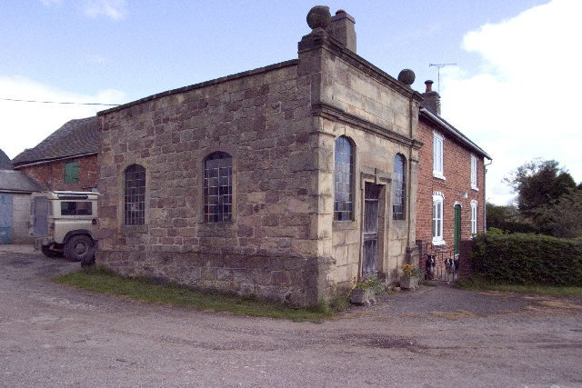
1197:== {{int:filedesc}} == {{Information |description={{en|1=Halter Devils Chapel. Halter Devils Chapel, Between Muggington and Mercaston, Derbyshire, SK267439
The Legend: One stormy night in 1723, a very drunken farmer called Francis Brown, decided to rid
275:
129:
lightning revealed that the animal had horns. He was so overcome by this that he remained sober for the rest of his life and built the chapel next to his house. In reality he had tried to halter one of his cows in his drunken state.
467:– You must give appropriate credit, provide a link to the license, and indicate if changes were made. You may do so in any reasonable manner, but not in any way that suggests the licensor endorses you or your use.
131:
A service is still held at this chapel on the last Sunday of the month, the farmer will give the key to see inside, (very nice) if you can find him and/or get past the noisy pack of dogs that roam around the
339:
289:
83:
768:
724:
680:
526:
51:
776:
784:
1099:
577:
1095:
1057:
993:
989:
925:
921:
772:
764:
676:
585:
581:
573:
883:
788:
780:
720:
569:
522:
792:
589:
1190:
727:"}},"text\/plain":{"en":{"P275":"Creative Commons Attribution-ShareAlike 2.0 Generic"}}}}": -->
592:"}},"text\/plain":{"en":{"P2699":"https:\/\/www.geograph.org.uk\/profile\/430"}}}}": -->
795:"}},"text\/plain":{"en":{"P973":"https:\/\/www.geograph.org.uk\/photo\/11358"}}}}": -->
818:
750:
706:
555:
349:
299:
853:
384:
1267:
This file contains additional information, probably added from the digital camera or scanner used to create or digitize it.
1125:
474:
633:
1109:
1067:
1034:
1007:
966:
939:
831:
802:
690:
654:
641:
626:
893:
861:
846:
734:
599:
539:
1179:
1174:
42:
1211:
430:
1270:
If the file has been modified from its original state, some details may not fully reflect the modified file.
529:"}},"text\/plain":{"en":{"P180":"Halter Devil Chapel"}}}}": -->
473:– If you remix, transform, or build upon the material, you must distribute your contributions under the
391:
on the
Geograph website for the photographer's contact details. The copyright on this image is owned by
1102:"}},"text\/plain":{"en":{"P1071":"Hulland Ward"}}}}": -->
224:
176:
683:"}},"text\/plain":{"en":{"P6216":"copyrighted"}}}}": -->
229:
181:
1207:
The following pages on the
English Knowledge use this file (pages on other projects are not listed):
1000:"}},"text\/plain":{"en":{"P7787":"22 degree"}}}}": -->
932:"}},"text\/plain":{"en":{"P7787":"22 degree"}}}}": -->
251:
203:
126:
Halter Devils Chapel. Halter Devils Chapel, Between
Mugginton and Mercaston, Derbyshire, SK267439
91:
427:
868:
838:
661:
8:
371:
1234:
355:
305:
396:
78:
255:
207:
162:
152:
1119:
1077:
1017:
949:
903:
812:
744:
700:
609:
549:
376:
1216:
388:
1147:
Click on a date/time to view the file as it appeared at that time.
245:
197:
341:
291:
326:
53° 00′ 04″ N, 1° 35′ 55″ W
276:
53° 00′ 04″ N, 1° 35′ 56″ W
141:
66:
515:
Add a one-line explanation of what this file represents
1254:
1244:
1205:
1225:
1145:
90:
Commons is a freely licensed media file repository.
751:
Creative
Commons Attribution-ShareAlike 2.0 Generic
725:
Creative
Commons Attribution-ShareAlike 2.0 Generic
116:Halter Devils Chapel - geograph.org.uk - 11358.jpg
52:Halter_Devils_Chapel_-_geograph.org.uk_-_11358.jpg
56:(640 × 427 pixels, file size: 86 KB, MIME type:
484:https://creativecommons.org/licenses/by-sa/2.0
71:
490:Creative Commons Attribution-Share Alike 2.0
408:
137:
113:
158:
147:
14:
997:
929:
793:https:\/\/www.geograph.org.uk\/photo\/11358
590:https:\/\/www.geograph.org.uk\/profile\/430
450:– to copy, distribute and transmit the work
1227:The following other wikis use this file:
869:https://www.geograph.org.uk/photo/11358
662:https://www.geograph.org.uk/profile/430
348:View this and other nearby images on:
298:View this and other nearby images on:
102:
395:and is licensed for reuse under the
316:
266:
256:entry Halter Devil Chapel Farmhouse
240:
192:
1138:
431:Attribution-Share Alike 2.0 Generic
419:
414:
399:Attribution-ShareAlike 2.0 license.
13:
1265:
520:
514:
405:
382:
222:
174:
120:
103:
49:
1291:
1272:
519:
1212:Listed buildings in Hulland Ward
1206:
940:coordinates of the point of view
922:coordinates of the point of view
505:
461:Under the following conditions:
426:This file is licensed under the
418:
413:
407:
375:
354:
340:
332:
304:
290:
282:
244:
196:
70:
31:
21:
502:
261:with data related to this item.
213:with data related to this item.
121:
46:No higher resolution available.
1222:
1142:
819:file available on the internet
769:file available on the internet
501:
383:This image was taken from the
26:
1:
1008:coordinates of depicted place
990:coordinates of depicted place
36:
1202:
854:Geograph Britain and Ireland
785:Geograph Britain and Ireland
627:object of statement has role
574:object of statement has role
535:Items portrayed in this file
367:
7:
1262:
331:
281:
10:
1296:
1251:Usage on pl.wikipedia.org
1241:Usage on fr.wikipedia.org
1231:Usage on fa.wikipedia.org
475:same or compatible license
218:
208:entry Halter Devil Chapel
170:
110:
105:
1139:
1023:53°0'4.14"N, 1°35'54.96"W
955:53°0'4.14"N, 1°35'55.68"W
16:
832:geograph.org.uk image ID
773:geograph.org.uk image ID
504:
441:
77:This is a file from the
41:
1196:
243:
195:
140:
81:. Information from its
1175:03:09, 30 January 2010
389:this photograph's page
360:53.001150; -1.598600
310:53.001150; -1.598800
84:description page there
1110:location of creation
1096:location of creation
556:Halter Devil Chapel
527:Halter Devil Chapel
456:– to adapt the work
223:This is a photo of
175:This is a photo of
642:author name string
582:author name string
1283:
1282:
1223:Global file usage
1200:
999:
931:
735:copyright license
721:copyright license
513:
404:
403:
387:collection. See
365:
364:
315:
314:
265:
264:
259:
239:
238:
217:
216:
211:
191:
190:
168:
167:
99:
98:
79:Wikimedia Commons
32:Global file usage
1287:
1273:
1187:
1149:
1045:
1044:
1039:
977:
976:
971:
871:
866:
862:described at URL
856:
851:
841:
836:
789:described at URL
691:copyright status
677:copyright status
664:
659:
649:
646:
636:
631:
511:
497:
494:
491:
488:
485:
477:as the original.
439:
428:Creative Commons
422:
421:
417:
416:
411:
410:
397:Creative Commons
385:Geograph project
379:
372:
361:
358:
344:
343:
337:
336:
335:
329:
328:
317:
311:
308:
294:
293:
287:
286:
285:
279:
278:
267:
257:
248:
241:
232:
219:
209:
200:
193:
184:
171:
143:
125:
117:
111:
95:
74:
73:
67:
61:
59:
1295:
1294:
1290:
1289:
1288:
1286:
1285:
1284:
1261:
1221:
1208:
1201:
1193:
1185:
1141:
1140:
1137:
1136:
1135:
1134:
1133:
1132:
1131:
1130:
1128:
1116:
1115:
1114:
1112:
1093:
1092:
1091:
1090:
1089:
1088:
1087:
1086:
1084:
1074:
1073:
1072:
1070:
1055:
1054:
1053:
1052:
1051:
1050:
1049:
1048:
1047:
1046:
1042:
1040:
1037:
1028:
1027:
1026:
1024:
1014:
1013:
1012:
1010:
987:
986:
985:
984:
983:
982:
981:
980:
979:
978:
974:
972:
969:
960:
959:
958:
956:
946:
945:
944:
942:
919:
918:
917:
916:
915:
914:
913:
912:
910:
900:
899:
898:
896:
881:
880:
879:
878:
877:
876:
875:
874:
873:
872:
867:
864:
858:
857:
852:
849:
843:
842:
837:
834:
825:
824:
823:
821:
809:
808:
807:
805:
762:
761:
760:
759:
758:
757:
756:
755:
753:
741:
740:
739:
737:
718:
717:
716:
715:
714:
713:
712:
711:
709:
697:
696:
695:
693:
674:
673:
672:
671:
670:
669:
668:
667:
666:
665:
660:
657:
651:
650:
647:
644:
638:
637:
632:
629:
620:
619:
618:
616:
606:
605:
604:
602:
567:
566:
565:
564:
563:
562:
561:
560:
558:
546:
545:
544:
542:
518:
517:
516:
499:
498:
495:
492:
489:
486:
483:
482:
440:
437:
434:
423:
400:
370:
359:
333:
324:
323:
320:Object location
309:
283:
274:
273:
270:Camera location
234:
228:
225:listed building
186:
180:
177:listed building
169:
153:geograph.org.uk
133:
115:
108:
101:
100:
89:
88:
87:is shown below.
63:
57:
55:
48:
47:
12:
11:
5:
1293:
1281:
1280:
1277:
1264:
1260:
1259:
1258:
1257:
1249:
1248:
1247:
1239:
1238:
1237:
1224:
1220:
1219:
1214:
1204:
1199:
1198:
1195:
1191:
1188:
1182:
1177:
1172:
1168:
1167:
1164:
1161:
1158:
1155:
1152:
1144:
1129:
1124:
1122:
1121:
1120:
1118:
1117:
1113:
1108:
1106:
1105:
1104:
1103:
1101:
1097:
1085:
1082:
1080:
1079:
1078:
1076:
1075:
1071:
1066:
1064:
1063:
1062:
1061:
1059:
1033:
1032:
1031:
1030:
1029:
1025:
1022:
1020:
1019:
1018:
1016:
1015:
1011:
1006:
1004:
1003:
1002:
1001:
995:
991:
965:
964:
963:
962:
961:
957:
954:
952:
951:
950:
948:
947:
943:
938:
936:
935:
934:
933:
927:
923:
911:
908:
906:
905:
904:
902:
901:
897:
892:
890:
889:
888:
887:
885:
860:
859:
845:
844:
830:
829:
828:
827:
826:
822:
817:
815:
814:
813:
811:
810:
806:
803:source of file
801:
799:
798:
797:
796:
794:
790:
786:
782:
778:
774:
770:
766:
765:source of file
754:
749:
747:
746:
745:
743:
742:
738:
733:
731:
730:
729:
728:
726:
722:
710:
705:
703:
702:
701:
699:
698:
694:
689:
687:
686:
685:
684:
682:
678:
653:
652:
640:
639:
625:
624:
623:
622:
621:
617:
614:
612:
611:
610:
608:
607:
603:
598:
596:
595:
594:
593:
591:
587:
583:
579:
575:
571:
559:
554:
552:
551:
550:
548:
547:
543:
538:
536:
533:
532:
531:
530:
528:
524:
510:
509:
506:
503:
481:
480:
479:
478:
468:
459:
458:
457:
451:
444:You are free:
435:
425:
424:
406:
402:
401:
380:
369:
366:
363:
362:
352:
346:
321:
313:
312:
302:
296:
271:
263:
262:
249:
237:
236:
215:
214:
201:
189:
188:
166:
165:
160:
156:
155:
149:
145:
144:
139:
135:
134:
118:
109:
107:
104:
97:
96:
75:
65:
64:
45:
40:
39:
34:
29:
24:
19:
9:
6:
4:
3:
2:
1292:
1278:
1275:
1274:
1271:
1268:
1256:
1253:
1252:
1250:
1246:
1243:
1242:
1240:
1236:
1233:
1232:
1230:
1229:
1228:
1218:
1215:
1213:
1210:
1209:
1194:
1189:
1183:
1181:
1178:
1176:
1173:
1170:
1169:
1165:
1162:
1159:
1156:
1153:
1151:
1150:
1148:
1127:
1123:
1111:
1107:
1081:
1069:
1065:
1036:
1021:
1009:
1005:
968:
953:
941:
937:
907:
895:
891:
870:
863:
855:
848:
840:
833:
820:
816:
804:
800:
752:
748:
736:
732:
708:
704:
692:
688:
663:
656:
643:
635:
628:
613:
601:
597:
557:
553:
541:
537:
534:
507:
500:
487:CC BY-SA 2.0
476:
472:
469:
466:
463:
462:
460:
455:
452:
449:
446:
445:
443:
442:
436:Attribution:
432:
429:
412:
398:
394:
390:
386:
381:
378:
374:
373:
357:
353:
351:
350:OpenStreetMap
347:
345:
327:
322:
319:
318:
307:
303:
301:
300:OpenStreetMap
297:
295:
277:
272:
269:
268:
260:
253:
250:
247:
242:
235:
231:
226:
221:
220:
212:
205:
202:
199:
194:
187:
183:
178:
173:
172:
164:
161:
157:
154:
150:
146:
136:
130:
124:
119:
112:
93:
86:
85:
80:
76:
69:
68:
62:
53:
44:
38:
35:
33:
30:
28:
25:
23:
20:
18:
15:
1269:
1266:
1226:
1146:
1143:File history
1126:Hulland Ward
1100:Hulland Ward
648:Rob Bradford
634:photographer
578:photographer
470:
464:
453:
447:
438:Rob Bradford
393:Rob Bradford
392:
330:
280:
163:Rob Bradford
127:
122:
92:You can help
82:
50:
22:File history
1192:GeographBot
707:copyrighted
681:copyrighted
471:share alike
465:attribution
258:(Q26403415)
210:(Q26452232)
114:Description
1276:_error
1203:File usage
1184:640 × 427
1160:Dimensions
1083:image/jpeg
1068:media type
1058:media type
909:6 May 2005
615:some value
142:6 May 2005
58:image/jpeg
27:File usage
1255:Mercaston
1245:Mercaston
1217:Mercaston
1157:Thumbnail
1154:Date/Time
894:inception
884:inception
368:Licensing
123:English:
1263:Metadata
847:operator
781:operator
508:Captions
454:to remix
448:to share
433:license.
252:Wikidata
204:Wikidata
37:Metadata
1235:مرکستون
1186:(86 KB)
1171:current
1166:Comment
1035:heading
994:heading
967:heading
926:heading
600:creator
570:creator
540:depicts
523:depicts
512:English
230:1109720
227:number
182:1158486
179:number
106:Summary
54:
1043:degree
998:degree
975:degree
930:degree
338:
288:
159:Author
148:Source
839:11358
777:11358
151:From
132:farm!
1163:User
496:true
493:true
254:has
206:has
138:Date
17:File
1041:22
973:22
655:URL
586:URL
1038::
970::
865::
850::
835::
658::
645::
630::
1279:0
233:.
185:.
94:.
60:)
Text is available under the Creative Commons Attribution-ShareAlike License. Additional terms may apply.
_heading:22.00&language=en)
_heading:22.00&language=en)