1262:"}},"text\/plain":{"en":{"":"author name string"}}},"{\"value\":\"Tom Fish\",\"type\":\"string\"}":{"text\/html":{"en":{"P2093":"Tom Fish"}},"text\/plain":{"en":{"P2093":"Tom Fish"}}},"{\"value\":{\"entity-type\":\"property\",\"numeric-id\":4174,\"id\":\"P4174\"},\"type\":\"wikibase-entityid\"}":{"text\/html":{"en":{"":"
43:
762:
1127:
1254:
393:
1133:
1103:
137:
161:
1138:
809:
724:
599:
99:
657:
1409:"}},"text\/plain":{"en":{"":"copyright license"}}},"{\"value\":{\"entity-type\":\"item\",\"numeric-id\":18199165,\"id\":\"Q18199165\"},\"type\":\"wikibase-entityid\"}":{"text\/html":{"en":{"P275":"
1365:"}},"text\/plain":{"en":{"":"copyright status"}}},"{\"value\":{\"entity-type\":\"item\",\"numeric-id\":50423863,\"id\":\"Q50423863\"},\"type\":\"wikibase-entityid\"}":{"text\/html":{"en":{"P6216":"
1497:"}},"text\/plain":{"en":{"":"media type"}}},"{\"value\":\"image\\\/png\",\"type\":\"string\"}":{"text\/html":{"en":{"P1163":"image\/png"}},"text\/plain":{"en":{"P1163":"image\/png"}}}}": -->
1453:"}},"text\/plain":{"en":{"":"source of file"}}},"{\"value\":{\"entity-type\":\"item\",\"numeric-id\":66458942,\"id\":\"Q66458942\"},\"type\":\"wikibase-entityid\"}":{"text\/html":{"en":{"P7482":"
1270:"}},"text\/plain":{"en":{"P4174":"Guerillero"}}},"{\"value\":{\"entity-type\":\"property\",\"numeric-id\":2699,\"id\":\"P2699\"},\"type\":\"wikibase-entityid\"}":{"text\/html":{"en":{"":"
1258:"}},"text\/plain":{"en":{"":"creator"}}},"{\"value\":{\"entity-type\":\"property\",\"numeric-id\":2093,\"id\":\"P2093\"},\"type\":\"wikibase-entityid\"}":{"text\/html":{"en":{"":"
1603:
1493:
615:
All versions of
Natural Earth raster + vector map data found on this website are in the public domain. You may use the maps in any manner, including modifying the content and design, electronic dissemination, and offset printing. The primary authors, Tom Patterson and Nathaniel Vaughn Kelso, and all
1274:"}},"text\/plain":{"en":{"":"URL"}}},"{\"value\":\"https:\\\/\\\/commons.wikimedia.org\\\/wiki\\\/User:Guerillero\",\"type\":\"string\"}":{"text\/html":{"en":{"P2699":"
1266:"}},"text\/plain":{"en":{"":"Wikimedia username"}}},"{\"value\":\"Guerillero\",\"type\":\"string\"}":{"text\/html":{"en":{"P4174":"
1624:. Reference: ''White Hurricane'', by David G. Brown, 2002. All text and icons were added to the PD blank map located at: http://walrus.wr.usgs.gov/infobank/gazette/jpg/regions/fr_glez.jpg {{PD-s
412:" either below the image, or make sure it is displayed after clicking on the photo; for printed media or for videos it is sufficient to mention the authorship in the imprint section or the description respectively)
1179:– You must give appropriate credit, provide a link to the license, and indicate if changes were made. You may do so in any reasonable manner, but not in any way that suggests the licensor endorses you or your use.
1267:
1643:
738:
1454:
1410:
1366:
1275:
1494:
1450:
1362:
1271:
1263:
1259:
1406:
1255:
65:
61:
57:
53:
47:
110:
78:
153:
1413:"}},"text\/plain":{"en":{"P275":"Creative Commons Attribution-ShareAlike 4.0 International"}}}}": -->
1278:"}},"text\/plain":{"en":{"P2699":"https:\/\/commons.wikimedia.org\/wiki\/User:Guerillero"}}}}": -->
616:
other contributors renounce all financial claim to the maps and invites you to use them for personal, educational, and commercial purposes.
455:
More information about the copyright of the data used and the current licenses of this image can be found on the file discription page in
437:
380:
827:
1602:
1597:
1480:
1436:
1392:
1799:
1648:
444:
1764:
This file contains additional information, probably added from the digital camera or scanner used to create or digitize it.
1186:
1504:
1464:
1376:
1340:
1325:
1312:
732:
1457:"}},"text\/plain":{"en":{"P7482":"original creation by uploader"}}}}": -->
516:
1741:
1420:
1285:
1244:
677:
831:
823:
1332:
778:
1148:
1658:
297:
1767:
If the file has been modified from its original state, some details may not fully reflect the modified file.
1093:
463:. Please ignore the mediaviewer used on Knowledge if it says this map is in the public domain. There is a
1185:– If you remix, transform, or build upon the material, you must distribute your contributions under the
459:. While some of the data used in this map may be in the public domain and tagged as such, the final map
1572:
1567:
69:
42:
1638:
1621:
1369:"}},"text\/plain":{"en":{"P6216":"copyrighted"}}}}": -->
1634:
The following pages on the
English Knowledge use this file (pages on other projects are not listed):
118:
1347:
148:
1145:
8:
369:
136:
629:
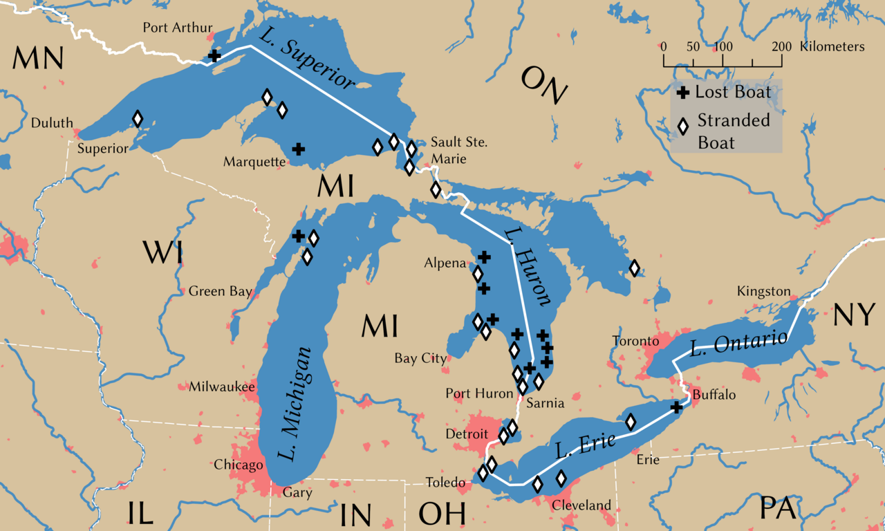
The locations of the shipwrecks are facts and are not eligible for copyright protection
609:
464:
822:
in the United States because it only contains materials that originally came from the
504:
White
Hurricane: A Great Lakes November Gale and America's Deadliest Maritime Disaster
160:
1721:
429:
I would appreciate being notified if you use my work outside of a
Wikimedia Project.
105:
1234:
1120:
I, the copyright holder of this work, hereby publish it under the following license:
331:
1676:
693:
467:
that the
Wikimedia Foundation is uninterested in fixing that causes this behavior.
1613:
1583:
753:
399:
If you wish to reuse this map outside
Wikimedia Foundation projects, you should:
1065:
1056:
745:
818:
672:
1793:
1653:
957:
1083:
1074:
1047:
1038:
1029:
1020:
1011:
1002:
993:
984:
975:
966:
948:
939:
930:
921:
912:
903:
894:
885:
876:
867:
858:
849:
840:
1644:
List of Great Lakes shipwrecks on the
National Register of Historic Places
535:
175:
1514:
1474:
1430:
1386:
1295:
666:
546:
392:
736:
employee, taken or made as part of that person's official duties. As a
1731:
1696:
434:
This tag does not indicate the copyright status of the attached work.
176:
143:
605:
1540:
Click on a date/time to view the file as it appeared at that time.
1751:
509:
1711:
422:
350:
542:
1437:
Creative
Commons Attribution-ShareAlike 4.0 International
1411:
Creative
Commons Attribution-ShareAlike 4.0 International
310:
93:
1686:
358:
1228:
Add a one-line explanation of what this file represents
497:
476:
1706:
1276:
https:\/\/commons.wikimedia.org\/wiki\/User:Guerillero
1632:
83:(4,000 × 2,400 pixels, file size: 799 KB, MIME type:
1667:
1538:
676:
because it consists entirely of information that is
117:
Commons is a freely licensed media file repository.
678:
common property and contains no original authorship
407:
364:
340:
218:
692:The international boundaries are sourced from the
484:
1691:
569:
403:Credit me as the cartographer (place the notice "
1791:
300:. Wreck locations come from Brown (2002, p. 203)
1196:https://creativecommons.org/licenses/by-sa/4.0
98:
1348:https://commons.wikimedia.org/User:Guerillero
1202:Creative Commons Attribution-Share Alike 4.0
1126:
375:
306:
282:
326:
316:
14:
1162:– to copy, distribute and transmit the work
238:
604:This file uses data that was sourced from
279:
1669:The following other wikis use this file:
1149:Attribution-Share Alike 4.0 International
687:
501:
828:United States Department of the Interior
696:published by the US Department of State
228:
182:
129:
1792:
777:The state boundaries are sourced from
752:per 17 U.S.C. § 101 and § 105 and the
624:
1649:List of shipwrecks in the Great Lakes
808:
723:
598:
285:Great Lakes 1913 Storm Shipwrecks.png
173:
803:
781:the United States Geological Survey
718:
694:Large Scale International Boundaries
651:
608:, a public domain dataset. From the
593:
506:, International Marine/McGraw-Hill
387:
131:
1722:Tempête de 1913 sur les Grands Lacs
1677:Grans Llacs d'Amèrica del Nord
1531:
1137:
1132:
746:
744:
739:work of the U.S. federal government
737:
731:
510:
508:
248:
142:This image appeared on Knowledge's
13:
1762:
1233:
1227:
1123:
1119:
1101:
832:the official USGS copyright policy
814:
760:
540:
480:NAD 1983 Great Lakes Basin Albers
290:
177:
174:
159:
130:
76:
1811:
1769:
1232:
772:
733:United States Department of State
178:
1633:
1218:
1173:Under the following conditions:
1144:This file is licensed under the
1136:
1131:
1125:
807:
754:Department Copyright Information
722:
655:
597:
534:
425:about other licenses/permissions
391:
135:
97:
31:
21:
1215:
824:United States Geological Survey
291:
152:column on 7 February 2005 (see
1664:
1535:
1214:
570:Rivers, lakes, and urban areas
456:
260:
223:Rivers, lakes, and urban areas
198:
26:
1:
1800:Knowledge Did you know images
1659:Knowledge:Recent additions 24
1481:original creation by uploader
1455:original creation by uploader
1066:
1057:
830:. For more information, see
36:
1629:
1622:en:Great Lakes Storm of 1913
1240:Items portrayed in this file
1113:
559:
502:Brown, David G. (2002)
188:
7:
1759:
1703:Usage on de.wiktionary.org
10:
1816:
1748:Usage on uz.wikipedia.org
1738:Usage on ru.wikipedia.org
1728:Usage on nl.wikipedia.org
1718:Usage on fr.wikipedia.org
1683:Usage on de.wikipedia.org
1673:Usage on ca.wikipedia.org
1187:same or compatible license
730:This image is a work of a
274:
1732:Grote Merenstorm van 1913
1697:Great Lakes Storm of 1913
1639:Great Lakes Storm of 1913
1532:
958:
492:
471:
320:
298:Great Lakes Storm of 1913
208:
16:
1217:
1153:
1084:
1075:
1048:
1039:
1030:
1021:
1012:
1003:
994:
985:
976:
967:
949:
940:
931:
922:
913:
904:
895:
886:
877:
868:
859:
850:
841:
477:Spatial reference system
104:This is a file from the
41:
1619:
1598:19:07, 27 February 2007
1590:Remedy copyright issues
1589:
564:
108:. Information from its
1620:Shipwrecks during the
1568:23:54, 8 November 2021
1106:
765:
742:, the image is in the
688:International boundary
472: Geotemporal data
296:Shipwrecks during the
243:International boundary
165:
111:description page there
46:Size of this preview:
1773:Horizontal resolution
1105:
816:This image is in the
764:
670:and therefore in the
163:
526:PNG development
368:// Creative Commons
70:4,000 × 2,400 pixels
66:2,560 × 1,536 pixels
1781:Vertical resolution
1168:– to adapt the work
826:, an agency of the
625:Shipwreck locations
493: Archival data
233:Shipwreck locations
52:Other resolutions:
1326:Wikimedia username
1313:author name string
1264:Wikimedia username
1260:author name string
1107:
766:
498:artwork-references
440:is still required.
166:
62:1,280 × 768 pixels
58:1,024 × 614 pixels
1788:
1787:
1665:Global file usage
1627:
1421:copyright license
1407:copyright license
1226:
1111:
1110:
1096:
802:
801:
770:
769:
717:
716:
685:
684:
650:
649:
622:
621:
592:
591:
556:
555:
545:was created with
520:
454:
453:
449:
445:Commons:Licensing
384:
381:Reusing this file
183:
170:
169:
126:
125:
106:Wikimedia Commons
32:Global file usage
1807:
1770:
1610:
1580:
1542:
1377:copyright status
1363:copyright status
1350:
1345:
1335:
1330:
1320:
1317:
1224:
1209:
1206:
1203:
1200:
1197:
1189:as the original.
1146:Creative Commons
1140:
1139:
1135:
1134:
1129:
1128:
1104:
1097:
1092:
842:Bahasa Indonesia
811:
810:
804:
798:
795:
792:
789:
784:
783:
763:
750:
748:
741:
735:
726:
725:
719:
713:
710:
707:
704:
699:
698:
659:
658:
652:
646:
643:
640:
637:
632:
631:
601:
600:
594:
588:
585:
582:
579:
574:
573:
538:
521:
514:
512:
507:
448:
441:
433:
410:
395:
388:
378:
367:
353:
343:
322:
312:
311:10 November 2021
295:
286:
280:
266:
263:
254:
251:
244:
241:
234:
231:
224:
221:
214:
211:
204:
201:
194:
191:
184:
139:
132:
122:
101:
100:
94:
88:
86:
73:
54:320 × 192 pixels
48:800 × 480 pixels
1815:
1814:
1810:
1809:
1808:
1806:
1805:
1804:
1790:
1789:
1758:
1663:
1635:
1628:
1616:
1608:
1586:
1578:
1534:
1533:
1530:
1529:
1528:
1527:
1526:
1525:
1524:
1523:
1521:
1511:
1510:
1509:
1507:
1492:
1491:
1490:
1489:
1488:
1487:
1486:
1485:
1483:
1471:
1470:
1469:
1467:
1448:
1447:
1446:
1445:
1444:
1443:
1442:
1441:
1439:
1427:
1426:
1425:
1423:
1404:
1403:
1402:
1401:
1400:
1399:
1398:
1397:
1395:
1383:
1382:
1381:
1379:
1360:
1359:
1358:
1357:
1356:
1355:
1354:
1353:
1352:
1351:
1346:
1343:
1337:
1336:
1331:
1328:
1322:
1321:
1318:
1315:
1306:
1305:
1304:
1302:
1292:
1291:
1290:
1288:
1253:
1252:
1251:
1250:
1249:
1247:
1231:
1230:
1229:
1212:
1211:
1210:
1207:
1204:
1201:
1198:
1195:
1194:
1152:
1141:
1122:
1121:
1116:
1102:
1086:
1077:
1068:
1059:
1050:
1041:
1032:
1023:
1014:
1005:
996:
987:
978:
969:
960:
951:
942:
933:
924:
915:
906:
897:
888:
879:
870:
861:
852:
843:
839:
836:
796:
793:
790:
787:
775:
761:
711:
708:
705:
702:
690:
665:ineligible for
656:
644:
641:
638:
635:
627:
586:
583:
580:
577:
572:
567:
562:
557:
552:
551:
550:
529:
442:
435:
406:
363:
354:
349:
339:
302:
301:
284:
277:
272:
264:
261:
252:
249:
242:
239:
232:
229:
222:
219:
212:
209:
202:
199:
192:
189:
185:
181:
172:
171:
128:
127:
116:
115:
114:is shown below.
90:
84:
82:
75:
74:
51:
12:
11:
5:
1813:
1803:
1802:
1786:
1785:
1782:
1778:
1777:
1774:
1761:
1757:
1756:
1755:
1754:
1746:
1745:
1744:
1736:
1735:
1734:
1726:
1725:
1724:
1716:
1715:
1714:
1709:
1701:
1700:
1699:
1694:
1689:
1681:
1680:
1679:
1666:
1662:
1661:
1656:
1651:
1646:
1641:
1631:
1626:
1625:
1618:
1614:
1611:
1607:1,786 × 1,194
1605:
1600:
1595:
1592:
1591:
1588:
1584:
1581:
1577:4,000 × 2,400
1575:
1570:
1565:
1561:
1560:
1557:
1554:
1551:
1548:
1545:
1537:
1522:
1519:
1517:
1516:
1515:
1513:
1512:
1508:
1503:
1501:
1500:
1499:
1498:
1496:
1484:
1479:
1477:
1476:
1475:
1473:
1472:
1468:
1465:source of file
1463:
1461:
1460:
1459:
1458:
1456:
1452:
1451:source of file
1440:
1435:
1433:
1432:
1431:
1429:
1428:
1424:
1419:
1417:
1416:
1415:
1414:
1412:
1408:
1396:
1391:
1389:
1388:
1387:
1385:
1384:
1380:
1375:
1373:
1372:
1371:
1370:
1368:
1364:
1339:
1338:
1324:
1323:
1311:
1310:
1309:
1308:
1307:
1303:
1300:
1298:
1297:
1296:
1294:
1293:
1289:
1284:
1282:
1281:
1280:
1279:
1277:
1273:
1269:
1265:
1261:
1257:
1248:
1243:
1241:
1238:
1237:
1236:
1235:
1223:
1222:
1219:
1216:
1193:
1192:
1191:
1190:
1180:
1171:
1170:
1169:
1163:
1156:You are free:
1143:
1142:
1124:
1118:
1117:
1115:
1112:
1109:
1108:
1099:
812:
800:
799:
774:
773:State boundary
771:
768:
767:
758:
727:
715:
714:
689:
686:
683:
682:
660:
648:
647:
626:
623:
620:
619:
602:
590:
589:
571:
568:
566:
563:
561:
558:
554:
553:
533:
532:
530:
527:
523:
522:
499:
495:
494:
490:
489:
486:
482:
481:
478:
474:
473:
469:
468:
452:
451:
427:
426:
414:
413:
396:
385:
373:
372:
360:
356:
355:
330:
328:
324:
323:
318:
314:
313:
308:
304:
303:
289:
287:
278:
276:
273:
271:
270:
269:
268:
258:
257:
256:
253:State boundary
246:
236:
226:
196:
180:
168:
167:
157:
140:
124:
123:
102:
92:
91:
45:
40:
39:
34:
29:
24:
19:
9:
6:
4:
3:
2:
1812:
1801:
1798:
1797:
1795:
1783:
1780:
1779:
1775:
1772:
1771:
1768:
1765:
1753:
1752:Buyuk koʻllar
1750:
1749:
1747:
1743:
1742:Великие озёра
1740:
1739:
1737:
1733:
1730:
1729:
1727:
1723:
1720:
1719:
1717:
1713:
1710:
1708:
1705:
1704:
1702:
1698:
1695:
1693:
1690:
1688:
1685:
1684:
1682:
1678:
1675:
1674:
1672:
1671:
1670:
1660:
1657:
1655:
1654:November 1913
1652:
1650:
1647:
1645:
1642:
1640:
1637:
1636:
1623:
1617:
1612:
1606:
1604:
1601:
1599:
1596:
1594:
1593:
1587:
1582:
1576:
1574:
1571:
1569:
1566:
1563:
1562:
1558:
1555:
1552:
1549:
1546:
1544:
1543:
1541:
1518:
1506:
1502:
1482:
1478:
1466:
1462:
1438:
1434:
1422:
1418:
1394:
1390:
1378:
1374:
1349:
1342:
1334:
1327:
1314:
1299:
1287:
1283:
1246:
1242:
1239:
1220:
1213:
1199:CC BY-SA 4.0
1188:
1184:
1181:
1178:
1175:
1174:
1172:
1167:
1164:
1161:
1158:
1157:
1155:
1154:
1150:
1147:
1130:
1100:
1098:
1095:
1091:
1087:
1082:
1078:
1073:
1069:
1064:
1060:
1055:
1051:
1046:
1042:
1037:
1033:
1028:
1024:
1019:
1015:
1010:
1006:
1001:
997:
992:
988:
983:
979:
974:
970:
965:
961:
956:
952:
947:
943:
938:
934:
929:
925:
920:
916:
911:
907:
902:
898:
893:
889:
884:
880:
875:
871:
866:
862:
857:
853:
848:
844:
837:
834:
833:
829:
825:
821:
820:
819:public domain
813:
806:
805:
791:Public domain
788:Public domain
786:
785:
782:
780:
759:
757:
755:
751:
749:
747:public domain
740:
734:
728:
721:
720:
706:Public domain
703:Public domain
701:
700:
697:
695:
681:
679:
675:
674:
673:public domain
669:
668:
663:This work is
661:
654:
653:
639:Public domain
636:Public domain
634:
633:
630:
618:
617:
611:
607:
606:Natural Earth
603:
596:
595:
581:Public domain
578:Public domain
576:
575:
548:
544:
537:
531:
525:
524:
518:
517:0-07-138037-X
513:
505:
500:
496:
491:
487:
483:
479:
475:
470:
466:
462:
458:
450:
446:
439:
438:copyright tag
432:
430:
424:
421:
420:
419:
418:
411:
409:
402:
401:
400:
397:
394:
390:
389:
386:
382:
377:
374:
371:
366:
361:
357:
352:
347:
342:
337:
333:
329:
325:
319:
315:
309:
305:
299:
294:
288:
281:
267:
259:
255:
247:
245:
237:
235:
227:
225:
217:
216:
215:
207:
206:
205:
197:
195:
187:
186:
162:
158:
155:
151:
150:
149:Did you know?
145:
141:
138:
134:
133:
120:
113:
112:
107:
103:
96:
95:
89:
80:
79:Original file
71:
67:
63:
59:
55:
49:
44:
38:
35:
33:
30:
28:
25:
23:
20:
18:
15:
1766:
1763:
1668:
1539:
1536:File history
1182:
1176:
1165:
1159:
1089:
1080:
1071:
1062:
1053:
1044:
1035:
1026:
1017:
1008:
999:
990:
981:
972:
963:
954:
945:
936:
927:
918:
909:
900:
891:
882:
873:
864:
855:
846:
838:
817:
815:
779:STATE_BOUNDS
776:
743:
729:
691:
671:
664:
662:
628:
614:
613:
610:terms of use
503:
488:1:11,792,324
460:
431:
428:
416:
415:
405:© Tom Fish,
404:
398:
362:© Tom Fish,
345:
335:
292:
147:
119:You can help
109:
77:
22:File history
1687:9. November
1393:copyrighted
1367:copyrighted
1183:share alike
1177:attribution
359:Credit line
283:Description
1784:314.96 dpc
1776:314.96 dpc
1712:Große Seen
1630:File usage
1615:SalomonCeb
1585:Guerillero
1553:Dimensions
1505:media type
1495:media type
1333:Guerillero
1301:some value
1268:Guerillero
1004:македонски
977:Tiếng Việt
932:Nederlands
547:ArcGIS Pro
457:#Licensing
423:Contact me
376:Permission
27:File usage
1609:(1.05 MB)
1550:Thumbnail
1547:Date/Time
1520:image/png
1114:Final Map
995:български
959:sicilianu
941:português
667:copyright
560:Licensing
528:InfoField
465:known bug
436:A normal
370:BY-SA 4.0
293:English:
265:Final Map
203:Licensing
164:Knowledge
144:Main Page
85:image/png
1794:Category
1760:Metadata
1707:Huronsee
1579:(799 KB)
1319:Tom Fish
1221:Captions
1166:to remix
1160:to share
1151:license.
923:italiano
905:français
408:geo.fish
365:geo.fish
351:Fish Eye
341:geo.fish
332:Tom Fish
321:Own work
179:Contents
154:archives
37:Metadata
1564:current
1559:Comment
1286:creator
1256:creator
1245:depicts
1225:English
1076:العربية
1013:русский
896:español
887:English
869:Deutsch
860:čeština
327:Creator
275:Summary
193:Summary
146:in the
81:
1088:
1079:
1070:
1067:中文(繁體)
1061:
1058:中文(简体)
1052:
1043:
1034:
1025:
1022:മലയാളം
1016:
1007:
998:
989:
986:Türkçe
980:
971:
962:
953:
950:polski
944:
935:
926:
917:
914:galego
908:
899:
890:
881:
872:
863:
854:
851:català
845:
541:This
539:
461:is not
348:
344:
338:
334:
317:Source
1085:فارسی
968:suomi
878:eesti
797:false
794:false
712:false
709:false
645:false
642:false
587:false
584:false
485:Scale
250:2.1.4
240:2.1.3
230:2.1.2
220:2.1.1
1692:1913
1556:User
1208:true
1205:true
565:Data
511:ISBN
443:See
307:Date
213:Data
17:File
1341:URL
1272:URL
1094:+/−
1040:日本語
1031:한국어
543:map
515::
262:2.2
210:2.1
1796::
1344::
1329::
1316::
1049:中文
612::
519:.
417:or
156:).
68:|
64:|
60:|
56:|
50:.
1090:∙
1081:∙
1072:∙
1063:∙
1054:∙
1045:∙
1036:∙
1027:∙
1018:∙
1009:∙
1000:∙
991:∙
982:∙
973:∙
964:∙
955:∙
946:∙
937:∙
928:∙
919:∙
910:∙
901:∙
892:∙
883:∙
874:∙
865:∙
856:∙
847:∙
835:.
756:.
680:.
549:.
447:.
383:)
379:(
346:·
336:·
200:2
190:1
121:.
87:)
72:.
Text is available under the Creative Commons Attribution-ShareAlike License. Additional terms may apply.
