1623:"}},"text\/plain":{"en":{"":"coordinates of the point of view"}}},"{\"value\":{\"latitude\":-23.686266,\"longitude\":132.673253,\"altitude\":null,\"precision\":1.0e-6,\"globe\":\"http:\\\/\\\/www.wikidata.org\\\/entity\\\/Q2\"},\"type\":\"globecoordinate\"}":{"text\/html":{"en":{"P1259":"23\u00b041'10.558"S, 132\u00b040'23.711"E"}},"text\/plain":{"en":{"P1259":"23\u00b041'10.558\"S, 132\u00b040'23.711\"E"}}}}": -->
797:
43:
1234:"}},"text\/plain":{"en":{"":"author name string"}}},"{\"value\":\"Toby Hudson\",\"type\":\"string\"}":{"text\/html":{"en":{"P2093":"Toby Hudson"}},"text\/plain":{"en":{"P2093":"Toby Hudson"}}},"{\"value\":{\"entity-type\":\"property\",\"numeric-id\":2699,\"id\":\"P2699\"},\"type\":\"wikibase-entityid\"}":{"text\/html":{"en":{"":"
807:
1453:"}},"text\/plain":{"en":{"":"inception"}}},"{\"value\":{\"time\":\"+2009-07-12T00:00:00Z\",\"timezone\":0,\"before\":0,\"after\":0,\"precision\":11,\"calendarmodel\":\"http:\\\/\\\/www.wikidata.org\\\/entity\\\/Q1985727\"},\"type\":\"time\"}":{"text\/html":{"en":{"P571":"12 July 2009"}},"text\/plain":{"en":{"P571":"12 July 2009"}}}}": -->
1210:
836:
778:
878:
1000:
850:
150:
915:
158:
168:
920:
232:
863:
103:
1392:"}},"text\/plain":{"en":{"P275":"Creative Commons Attribution-ShareAlike 3.0 Unported"}}},"{\"value\":{\"entity-type\":\"item\",\"numeric-id\":50829104,\"id\":\"Q50829104\"},\"type\":\"wikibase-entityid\"}":{"text\/html":{"en":{"P275":"
1813:
1535:"}},"text\/plain":{"en":{"":"Commons quality assessment"}}},"{\"value\":{\"entity-type\":\"item\",\"numeric-id\":63348049,\"id\":\"Q63348049\"},\"type\":\"wikibase-entityid\"}":{"text\/html":{"en":{"P6731":"
1226:"}},"text\/plain":{"en":{"":"object of statement has role"}}},"{\"value\":{\"entity-type\":\"item\",\"numeric-id\":33231,\"id\":\"Q33231\"},\"type\":\"wikibase-entityid\"}":{"text\/html":{"en":{"P3831":"
1388:"}},"text\/plain":{"en":{"":"copyright license"}}},"{\"value\":{\"entity-type\":\"item\",\"numeric-id\":14946043,\"id\":\"Q14946043\"},\"type\":\"wikibase-entityid\"}":{"text\/html":{"en":{"P275":"
1344:"}},"text\/plain":{"en":{"":"copyright status"}}},"{\"value\":{\"entity-type\":\"item\",\"numeric-id\":50423863,\"id\":\"Q50423863\"},\"type\":\"wikibase-entityid\"}":{"text\/html":{"en":{"P6216":"
1491:"}},"text\/plain":{"en":{"":"source of file"}}},"{\"value\":{\"entity-type\":\"item\",\"numeric-id\":66458942,\"id\":\"Q66458942\"},\"type\":\"wikibase-entityid\"}":{"text\/html":{"en":{"P7482":"
1759:
1729:
1230:"}},"text\/plain":{"en":{"P3831":"photographer"}}},"{\"value\":{\"entity-type\":\"property\",\"numeric-id\":2093,\"id\":\"P2093\"},\"type\":\"wikibase-entityid\"}":{"text\/html":{"en":{"":"
1579:"}},"text\/plain":{"en":{"":"captured with"}}},"{\"value\":{\"entity-type\":\"item\",\"numeric-id\":64100,\"id\":\"Q64100\"},\"type\":\"wikibase-entityid\"}":{"text\/html":{"en":{"P4082":"
1167:"}},"text\/plain":{"en":{"":"depicts"}}},"{\"value\":{\"entity-type\":\"item\",\"numeric-id\":60760428,\"id\":\"Q60760428\"},\"type\":\"wikibase-entityid\"}":{"text\/html":{"en":{"P180":"
1222:"}},"text\/plain":{"en":{"P4174":"99of9"}}},"{\"value\":{\"entity-type\":\"property\",\"numeric-id\":3831,\"id\":\"P3831\"},\"type\":\"wikibase-entityid\"}":{"text\/html":{"en":{"":"
1214:"}},"text\/plain":{"en":{"":"creator"}}},"{\"value\":{\"entity-type\":\"property\",\"numeric-id\":4174,\"id\":\"P4174\"},\"type\":\"wikibase-entityid\"}":{"text\/html":{"en":{"":"
1619:
729:
australien. L'orogénie d'Alice
Springs a redressé une dalle de 12 km de quartzites rouges sur une longueur de 644 km. La gorge a été creusée dans cette dalle, qui a mieux supporté l'érosion que les roches plus tendres qui l'entouraient au moment de l'orogénie. La chaine est totalement incluse dans un
705:
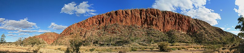
This geological formation is part of the West MacDonnell Ranges in
Australia's Northern Territory. The layers once lay horizontal at the bottom of the Amadeus basin. The Alice Springs orogeny pushed a 12km thick slab vertical, running roughly east-west for 644km. This gorge is primarily formed of
701:
A panoramic view of the western wall of the Glen Helen Gorge in the late afternoon. The Gorge itself can be seen in between peaks on the left. The Finke river, with its mostly dry river bed and glimpses of water, can be seen in the foreground. The trees along the river bed are primarily River Red
294:
in die MacDonnellgebergte. Die gebergte bestaan uit 'n aantal ewewydig gerangskikte bergkettings in die territorium. Dit is gevorm toe die Alice
Springs orogenese ('n bergvorming vernoem na die gelyknamige dorp) oor 'n lengte van 644km 'n laag rots van 12km dikte, rofweg van oos na wes, vertikaal
1238:"}},"text\/plain":{"en":{"":"URL"}}},"{\"value\":\"https:\\\/\\\/commons.wikimedia.org\\\/wiki\\\/User:99of9\",\"type\":\"string\"}":{"text\/html":{"en":{"P2699":"
717:
Vue panoramique du bord ouest de la gorge Glen Helen en fin d'après-midi. La gorge elle même est visible entre les sommets sur la gauche de l'image. Le lit de la rivière Finke, avec un peu d'eau, est au premier plan. Les arbres qui la bordent sont principalement des
289:
Vandag is dit "Territory Day" (d.w.s. "Territoriumdag") in die
Australiese Noordelike Territorium, 'n dag wat geskiedkundig beskou word as die dag waarop die territorium selfbestuur verkry het, naamlik 1 Julie 1978. Die foto toon die westelike rand van die
1218:"}},"text\/plain":{"en":{"":"Wikimedia username"}}},"{\"value\":\"99of9\",\"type\":\"string\"}":{"text\/html":{"en":{"P4174":"
1776:{{Information |Description={{en|1=A panoramic view of the western wall of the Glen Helen Gorge in the late afternoon. The Gorge itself can be seen in between peaks on the left. The Finke river, with its mostly dry river bed, and glimpses of water can be
616:আজ অস্ট্রেলিয়ার নর্দার্ন টেরিটতে আজকে ‘টেরিটরি দিবস’। এই দিনে এখানে ১৯৭৮ সালের ১ জুলাই পাওয়া স্বায়ত্বশাসন উদযাপন করা হয়। এই আলোকচিত্রে গ্লেন হেলেন জর্জের পশ্চিম দিকের দেওয়ালটি ফুটিয়ে তোলা হয়েছে। এটি নর্দার্ন টেরিটরির পশ্চিম ম্যাকডানেল রেঞ্জের অংশ।
601:
185:
827:
961:– You must give appropriate credit, provide a link to the license, and indicate if changes were made. You may do so in any reasonable manner, but not in any way that suggests the licensor endorses you or your use.
833:
1973:
1219:
1983:
644:今日7月1日はノーザンテリトリー(オーストラリア)の「テリトリー・デー」。ノーザンテリトリーは準州として1978年7月1日に自治権を獲得した。写真は同テリトリーに位置する西マクドネル山脈の一部をなすグレン・ヘレン峡谷の西壁。マクドネル山脈はアリススプリングス造山運動の際、概ね東西方向644kmにわたる厚さ12kmの岩盤が押されることで形成されたものである。
580:
1536:
1492:
1393:
1389:
1345:
1168:
530:
til minne om innførselen av selvstyre for territoriet 1. juli 1978. Dette bildet viser vestsiden av Glen Helen Gorge, som er en del av MacDonnell Ranges i
Nordterritoriet.
1239:
69:
65:
61:
1580:
1227:
57:
53:
47:
407:
en
Australia Central. Hoy es el Territory Day (‘día del territorio’) en el Territorio del Norte, el aniversario de la institución del gobierno federal (1 de julio de
1620:
1576:
1532:
1488:
1341:
1235:
1231:
1223:
1215:
114:
1450:
1385:
1211:
1164:
788:
82:
370:, and marks the commencement of self-government in the Territory on 1st July 1978. This photograph is of the western wall of the Glen Helen Gorge, part of the
264:, and marks the commencement of self-government in the Territory on 1st July 1978. This photograph is of the western wall of the Glen Helen Gorge, part of the
345:. Das Datum markiert den Beginn der Selbstverwaltung dieses Territoriums am 1. Juli 1978. Dieses Foto zeigt die Westwand der Glen Helen Gorge, ein Teil der
1017:
1928:
706:
red quartzite, which withstood subsequent erosion better than the softer layers around it. The entire Ranges have been classified as
National Park.
2073:
1396:"}},"text\/plain":{"en":{"P275":"GNU Free Documentation License, version 1.2 or later"}}}}": -->
1242:"}},"text\/plain":{"en":{"P2699":"https:\/\/commons.wikimedia.org\/wiki\/User:99of9"}}}}": -->
560:
1758:
1753:
1728:
1723:
597:
1015:; with no Invariant Sections, no Front-Cover Texts, and no Back-Cover Texts. A copy of the license is included in the section entitled
328:
til minde om indførelsen af selvstyre for territoriet 1. juli 1978. Dette foto viser vestsiden af Glen Helen Gorge, der er en del af
709:
In the right foreground a couple can be seen enjoying the romantic scene on a bench below the balcony of the Glen Helen camp ground.
2078:
513:) over een lengte van 644 kilometer een 12 kilometer dikke laag rots verticaal omhoog drukte, grofweg in oost-westelijke richting.
544:
1562:
1518:
1436:
1419:
1371:
1197:
843:
667:
654:
625:
497:, historisch gezien de dag waarop het territorium zelfbestuur verkreeg op 1 juli 1978. De foto toont de westelijke rand van de
2118:
505:. Dit gebergte bestaat uit een aantal evenwijdig aan elkaar gelegen bergketens in het territorium die werden gevormd toen de
2131:
This file contains additional information, probably added from the digital camera or scanner used to create or digitize it.
1539:"}},"text\/plain":{"en":{"P6731":"Wikimedia Commons featured picture"}}}}": -->
968:
584:
205:
1606:
1298:
1630:
1590:
1546:
1502:
1355:
1319:
1306:
1291:
1276:
605:
387:
La pared occidental del Glen Helen Gorge, en la cadena montañosa de 640 km de longitud del West MacDonnell Ranges en el
1495:"}},"text\/plain":{"en":{"P7482":"original creation by uploader"}}}}": -->
1007:
1460:
1403:
1249:
1181:
796:
2108:
733:
Sur la droite, un couple admire le paysage depuis un banc situé au pied de la terrasse du camping de Glen Helen.
2218:
1698:
1693:
73:
42:
930:
702:
Gums. The cloud cover is the start of an infrequent dry season cold front which brought rains to the region.
632:
353:
von Alice
Springs eine 12km dicke Felsplatte vertikal verschob. Sie verläuft etwa 644km in Ost/West-Richtung.
2134:
If the file has been modified from its original state, some details may not fully reflect the modified file.
2113:
1908:
1283:
1012:
1746:
Resaved with EXIF data embedded and cloned dark regions of upper left sky (per User:Sting, thanks again!)
1171:"}},"text\/plain":{"en":{"P180":"Glen Helen Gorge"}}}}": -->
722:. Les nuages annoncent un front froid porteur de pluie, un évènement peu fréquent durant la saison sèche.
240:
1583:"}},"text\/plain":{"en":{"P4082":"Canon EOS 400D"}}}}": -->
967:– If you remix, transform, or build upon the material, you must distribute your contributions under the
149:
181:
1348:"}},"text\/plain":{"en":{"P6216":"copyrighted"}}}}": -->
494:
2063:
1786:
The following pages on the
English Knowledge use this file (pages on other projects are not listed):
1059:
400:
628:
308:
388:
371:
265:
245:
201:
122:
2153:
2098:
2048:
2003:
1948:
1938:
806:
473:
441:
433:
375:
269:
2058:
2028:
1993:
1853:
2038:
1005:
Permission is granted to copy, distribute and/or modify this document under the terms of the
726:
502:
342:
321:
311:; dnes se v Severním teritoriu slaví výročí získání autonomie 1. července 1978
2018:
1326:
927:
481:
456:) nel Territorio del Nord, l'anniversario dell'istituzione del governo federale (1º luglio
346:
329:
8:
2195:
567:
480:ünnepe, a Territory önkormányzatának 1978. július 1-jei születésére emlékezik. A fotón a
363:
257:
2013:
884:
849:
523:
506:
425:
193:
1790:
902:
I, the copyright holder of this work, hereby publish it under the following licenses:
869:
350:
109:
470:
1903:
719:
510:
396:
2143:
197:
1963:
725:
Cette formation géologique fait partie de la chaine des West MacDonnell dans le
305:
378:
pushed a 12km thick slab of rock vertical, running roughly east-west for 644km.
272:
pushed a 12km thick slab of rock vertical, running roughly east-west for 644km.
226:
579:Западниот бедем на клисурата Глен Хелен на планинскиот венец Вест Макдонел во
325:
527:
437:
392:
877:
2266:
1640:
1600:
1556:
1512:
1470:
1430:
1413:
1365:
1259:
1191:
777:
762:
564:
1958:
1795:
1769:
1739:
1709:
548:
436:, in Australia. Queste frastagliate montagne si sono formate durante l'
367:
261:
1843:
493:
Vandaag is het "Territory Day" ("Territoriumdag") in het
Australische
304:
Západní stěna Glen Helen Gorge, části pohoří MacDonnell Ranges v
192:
If you have an image of similar quality that can be published under a
994:
404:
1666:
Click on a date/time to view the file as it appeared at that time.
445:
1893:
1883:
1823:
862:
828:
23° 41′ 10.56″ S, 132° 40′ 23.71″ E
457:
408:
184:) and is considered one of the finest images. See its nomination
1863:
835:
1833:
1873:
888:
374:
in the Northern Territory. These ranges were formed when the
268:
in the Northern Territory. These ranges were formed when the
349:. Diese Gebirgszüge wurden gebildet, als sich während der
742:
97:
1868:
1918:
1157:
Add a one-line explanation of what this file represents
87:(10,609 × 2,340 pixels, file size: 17.6 MB, MIME type:
2074:
Knowledge:Danh sách hình ảnh chọn lọc của Commons/2009
2088:
1784:
1804:
1664:
1437:
GNU Free Documentation License, version 1.2 or later
1420:
Creative Commons Attribution-ShareAlike 3.0 Unported
1394:
GNU Free Documentation License, version 1.2 or later
1390:
Creative Commons Attribution-ShareAlike 3.0 Unported
1011:, Version 1.2 or any later version published by the
121:
Commons is a freely licensed media file repository.
789:
Red Centre Itinerary (GlenHelenGorge) WV banner.jpg
135:
2004:Wikiprojekt:Ilustrowanie/Medalowe zasoby Commons/7
1133:
1108:
1083:
1240:https:\/\/commons.wikimedia.org\/wiki\/User:99of9
1130:
1105:
1080:
136:
2019:Knowledge:Imagem em destaque/1 de julho de 2010
1716:Same image but with sRGB color profile embedded
341:Heute ist "Territory Day" in den australischen
1136:
1111:
1086:
978:https://creativecommons.org/licenses/by-sa/3.0
395:. Esta fracturada montaña se formó durante la
102:
1127:
1124:
1121:
1118:
1102:
1099:
1096:
1093:
1077:
1074:
1071:
1068:
984:Creative Commons Attribution-Share Alike 3.0
908:
738:
691:GlenHelenGorge NorthernTerritory Panorama.jpg
688:
768:
758:
748:
670:格蘭海倫峽谷風景。這些山脈因艾麗絲泉造山運動形成12公里厚的垂直岩石板,延綿644公里。
657:格兰海伦峡谷风景。这些山脉因艾丽丝泉造山运动形成12公里厚的垂直岩石板,延绵644公里。
14:
1909:Wikipédia:Kezdőlapműhely/A nap képe/2010-07
1117:
1092:
1067:
944:– to copy, distribute and transmit the work
2014:Knowledge:Imagem em destaque/Julho de 2010
1814:উইকিপিডিয়া:আজকের নির্বাচিত ছবি/জুলাই ২০১০
1043:You may select the license of your choice.
231:
2079:Thành viên:Phương Huy/Phong cảnh/Chọn lọc
1806:The following other wikis use this file:
167:
1327:https://commons.wikimedia.org/User:99of9
805:
563:över västra sidan av Glen Helen Gorge i
157:
659:
1138:Couple enjoying the romantic scenery.
842:View this and other nearby images on:
448:fa nell'Australia Centrale. Oggi è il
133:
1047:
1023:http://www.gnu.org/copyleft/fdl.html
931:Attribution-Share Alike 3.0 Unported
818:
772:
1964:Knowledge:Sary/*/Herinandro 48 2019
1657:
919:
914:
13:
2129:
1974:Википедија:Избрана слика/2010/јули
1563:Wikimedia Commons featured picture
1537:Wikimedia Commons featured picture
1162:
1156:
1042:
905:
901:
882:
867:
711:
695:
646:
637:
618:
609:
589:
572:
553:
532:
515:
486:
462:
413:
380:
355:
334:
313:
297:
282:
250:
148:
134:
80:
2291:
2136:
1161:
2279:804ec332263974d9197fcd02f9e605c8
2160:Date and time of data generation
1785:
1631:coordinates of the point of view
1621:coordinates of the point of view
1147:
999:
998:
955:Under the following conditions:
926:This file is licensed under the
918:
913:
907:
876:
861:
848:
834:
795:
776:
362:Today is "Territory Day" in the
256:Today is "Territory Day" in the
230:
166:
156:
101:
31:
21:
1646:23°41'10.558"S, 132°40'23.711"E
1144:
1060:View the annotations at Commons
696:
522:I dag er det «Territory Day» i
320:I dag er det "Territory Day" i
251:
1801:
1661:
1143:
1029:GNU Free Documentation License
1018:GNU Free Documentation License
1008:GNU Free Documentation License
712:
660:
403:ocurrido hace entre 450 y 300
248:. It was captioned as follows:
26:
1:
1519:original creation by uploader
1493:original creation by uploader
868:This image was created with
444:intercorso tra i 450 e i 300
36:
1904:Wikipédia:A nap képe/2010-07
1781:
1292:object of statement has role
1224:object of statement has role
1177:Items portrayed in this file
895:
509:van Alice Springs (naar het
440:di Alice Springs, un evento
7:
2229:Date and time of digitizing
2126:
2095:Usage on xal.wikipedia.org
2045:Usage on sah.wikipedia.org
1959:Knowledge:Sary/*/taona 2019
1945:Usage on lbe.wikipedia.org
1935:Usage on krc.wikipedia.org
1915:Usage on it.wikivoyage.org
1860:Usage on en.wikivoyage.org
1840:Usage on crh.wikipedia.org
1830:Usage on ceb.wikipedia.org
397:orogenésis de Alice Springs
238:This image was selected as
10:
2296:
2258:Supported Flashpix version
2105:Usage on zh.wikipedia.org
2085:Usage on www.wikidata.org
2070:Usage on vi.wikipedia.org
2055:Usage on uk.wikipedia.org
2025:Usage on ru.wikipedia.org
2010:Usage on pt.wikipedia.org
2000:Usage on pl.wikipedia.org
1990:Usage on os.wikipedia.org
1980:Usage on ml.wikipedia.org
1970:Usage on mk.wikipedia.org
1955:Usage on mg.wikipedia.org
1925:Usage on ko.wikipedia.org
1900:Usage on hu.wikipedia.org
1890:Usage on eu.wikipedia.org
1880:Usage on es.wikipedia.org
1850:Usage on cv.wikipedia.org
1820:Usage on ca.wikipedia.org
1810:Usage on bn.wikipedia.org
1547:Commons quality assessment
1533:Commons quality assessment
969:same or compatible license
685:
680:
428:(640 km di lunghezza) dei
420:La parete occidentale del
194:suitable copyright license
140:
2237:Meaning of each component
2202:File change date and time
2035:Usage on ru.wikinews.org
1658:
1057:This image is annotated:
752:
647:
638:
619:
610:
590:
573:
554:
533:
516:
487:
463:
414:
381:
356:
335:
314:
298:
283:
244:on Wikimedia Commons for
164:
147:
16:
2119:Knowledge:每日图片/2010年7月1日
1146:
1013:Free Software Foundation
935:
237:
108:This is a file from the
41:
1775:
1745:
1715:
854:-23.686266; 132.673253
775:
741:
454:«giorno del territorio»
112:. Information from its
2205:19:14, 29 October 2009
2154:Canon EOS 400D DIGITAL
2109:Knowledge:每日图片/2010年7月
1754:07:00, 23 October 2009
1724:14:04, 23 October 2009
1694:21:24, 29 October 2009
811:
495:Noordelijk Territorium
430:West MacDonnell Ranges
372:West MacDonnell Ranges
347:West MacDonnell Ranges
332:i Northern Territory.
266:West MacDonnell Ranges
180:on Wikimedia Commons (
154:
115:description page there
46:Size of this preview:
2176:Horizontal resolution
1894:MacDonnell mendikatea
1884:Cordillera MacDonnell
809:
474:Northern Territoryban
376:Alice Springs Orogeny
270:Alice Springs Orogeny
152:
74:10,609 × 2,340 pixels
1929:위키백과:오늘의 그림/2010년 7월
1824:Serralada MacDonnell
602:Северных Территориях
581:Северната Територија
484:nyugati fala látható
389:Territorio del Norte
2232:16:57, 12 July 2009
2210:Y and C positioning
2196:Adobe Photoshop 7.0
2184:Vertical resolution
2163:16:57, 12 July 2009
2140:Camera manufacturer
2099:Кевләр:Potd/2010-07
2059:Шаблон:Potd/2010-07
2049:Халыып:Potd/2010-07
2039:Шаблон:Potd/2010-07
2029:Шаблон:Potd/2010-07
1994:Шаблон:Potd/2010-07
1949:Шаблон:Potd/2010-07
1939:Шаблон:Potd/2010-07
1854:Шаблон:Potd/2010-07
1844:Şablon:Potd/2010-07
950:– to adapt the work
545:Território do Norte
511:gelijknamige stadje
501:, een kloof in het
434:Territorio del Nord
153:Picture of the year
52:Other resolutions:
1864:Northern Territory
1307:author name string
1277:Wikimedia username
1232:author name string
1216:Wikimedia username
812:
727:Territoire du Nord
568:Northern Territory
503:MacDonnellgebergte
364:Northern Territory
343:Northern Territory
322:Northern Territory
309:Severním teritoriu
295:omhoog gedruk het.
258:Northern Territory
241:picture of the day
155:
70:2,560 × 565 pixels
66:1,280 × 282 pixels
62:1,024 × 226 pixels
2283:
2282:
1834:Macdonnell Ranges
1802:Global file usage
1791:MacDonnell Ranges
1779:
1404:copyright license
1386:copyright license
1155:
1088:Glen Helen Gorge
1066:
1065:
1040:
1039:
887:was created with
859:
858:
816:
815:
804:
803:
783:This file has an
678:
677:
330:MacDonnell Ranges
222:
221:
218:
217:
214:
213:
182:Featured pictures
130:
129:
110:Wikimedia Commons
32:Global file usage
2287:
2137:
1984:മക്ഡൊണെൽ റേഞ്ചസ്
1766:
1736:
1706:
1668:
1356:copyright status
1342:copyright status
1329:
1324:
1314:
1311:
1301:
1296:
1286:
1281:
1198:Glen Helen Gorge
1169:Glen Helen Gorge
1153:
1113:Finke River bed
1048:
1036:
1033:
1030:
1027:
1024:
1002:
1001:
995:
991:
988:
985:
982:
979:
971:as the original.
928:Creative Commons
922:
921:
917:
916:
911:
910:
880:
865:
855:
852:
838:
837:
831:
830:
819:
799:
780:
773:
754:
744:
716:
714:Français :
700:
692:
686:
665:
652:
643:
624:
615:
595:
578:
559:
541:Glen Helen Gorge
538:
521:
499:Glen Helen Gorge
492:
482:Glen Helen Gorge
468:
422:Glen Helen Gorge
419:
405:millones de años
386:
361:
340:
319:
303:
292:Glen Helen Kloof
288:
278:
277:Other languages:
255:
234:
233:
227:
178:featured picture
170:
169:
160:
159:
145:
144:
141:
137:
126:
105:
104:
98:
92:
90:
77:
58:640 × 141 pixels
48:798 × 176 pixels
2295:
2294:
2290:
2289:
2288:
2286:
2285:
2284:
2276:Unique image ID
2125:
1874:Mountain ranges
1800:
1787:
1780:
1772:
1764:
1763:10,609 × 2,340
1742:
1734:
1733:10,609 × 2,340
1712:
1704:
1703:10,609 × 2,340
1660:
1659:
1656:
1655:
1654:
1653:
1652:
1651:
1650:
1649:
1647:
1637:
1636:
1635:
1633:
1618:
1617:
1616:
1615:
1614:
1613:
1612:
1611:
1609:
1597:
1596:
1595:
1593:
1574:
1573:
1572:
1571:
1570:
1569:
1568:
1567:
1565:
1553:
1552:
1551:
1549:
1530:
1529:
1528:
1527:
1526:
1525:
1524:
1523:
1521:
1509:
1508:
1507:
1505:
1486:
1485:
1484:
1483:
1482:
1481:
1480:
1479:
1477:
1467:
1466:
1465:
1463:
1448:
1447:
1446:
1445:
1444:
1443:
1442:
1441:
1439:
1428:
1427:
1426:
1425:
1424:
1422:
1410:
1409:
1408:
1406:
1383:
1382:
1381:
1380:
1379:
1378:
1377:
1376:
1374:
1362:
1361:
1360:
1358:
1339:
1338:
1337:
1336:
1335:
1334:
1333:
1332:
1331:
1330:
1325:
1322:
1316:
1315:
1312:
1309:
1303:
1302:
1297:
1294:
1288:
1287:
1282:
1279:
1270:
1269:
1268:
1266:
1256:
1255:
1254:
1252:
1209:
1208:
1207:
1206:
1205:
1204:
1203:
1202:
1200:
1188:
1187:
1186:
1184:
1160:
1159:
1158:
1141:
1140:
1135:
1132:
1129:
1126:
1123:
1120:
1116:
1115:
1110:
1107:
1104:
1101:
1098:
1095:
1091:
1090:
1085:
1082:
1079:
1076:
1073:
1070:
1054:
1046:
1045:
1044:
1034:
1031:
1028:
1025:
1022:
993:
992:
989:
986:
983:
980:
977:
976:
934:
923:
904:
903:
898:
893:
892:
874:
873:
853:
826:
825:
822:Camera location
817:
810:The Gorge only.
800:
785:extracted image
734:
720:Gommiers rouges
710:
690:
683:
674:
673:
672:
671:
663:
658:
650:
645:
641:
636:
622:
617:
613:
608:
593:
588:
576:
571:
557:
552:
536:
531:
524:Nordterritoriet
519:
514:
490:
485:
466:
461:
450:“Territory Day”
426:catena montuosa
417:
412:
384:
379:
359:
354:
338:
333:
317:
312:
301:
296:
286:
279:
276:
273:
249:
223:
132:
131:
120:
119:
118:is shown below.
94:
88:
86:
79:
78:
54:320 × 71 pixels
51:
12:
11:
5:
2293:
2281:
2280:
2277:
2273:
2272:
2269:
2263:
2262:
2259:
2255:
2254:
2253:
2252:
2251:does not exist
2249:
2246:
2243:
2238:
2234:
2233:
2230:
2226:
2225:
2222:
2215:
2214:
2211:
2207:
2206:
2203:
2199:
2198:
2193:
2189:
2188:
2185:
2181:
2180:
2177:
2173:
2172:
2169:
2165:
2164:
2161:
2157:
2156:
2151:
2147:
2146:
2141:
2128:
2124:
2123:
2122:
2121:
2116:
2111:
2103:
2102:
2101:
2093:
2092:
2091:
2083:
2082:
2081:
2076:
2068:
2067:
2066:
2061:
2053:
2052:
2051:
2043:
2042:
2041:
2033:
2032:
2031:
2023:
2022:
2021:
2016:
2008:
2007:
2006:
1998:
1997:
1996:
1988:
1987:
1986:
1978:
1977:
1976:
1968:
1967:
1966:
1961:
1953:
1952:
1951:
1943:
1942:
1941:
1933:
1932:
1931:
1923:
1922:
1921:
1913:
1912:
1911:
1906:
1898:
1897:
1896:
1888:
1887:
1886:
1878:
1877:
1876:
1871:
1866:
1858:
1857:
1856:
1848:
1847:
1846:
1838:
1837:
1836:
1828:
1827:
1826:
1818:
1817:
1816:
1803:
1799:
1798:
1793:
1783:
1778:
1777:
1774:
1770:
1767:
1761:
1756:
1751:
1748:
1747:
1744:
1740:
1737:
1731:
1726:
1721:
1718:
1717:
1714:
1710:
1707:
1701:
1696:
1691:
1687:
1686:
1683:
1680:
1677:
1674:
1671:
1663:
1648:
1645:
1643:
1642:
1641:
1639:
1638:
1634:
1629:
1627:
1626:
1625:
1624:
1622:
1610:
1607:Canon EOS 400D
1605:
1603:
1602:
1601:
1599:
1598:
1594:
1589:
1587:
1586:
1585:
1584:
1582:
1581:Canon EOS 400D
1578:
1566:
1561:
1559:
1558:
1557:
1555:
1554:
1550:
1545:
1543:
1542:
1541:
1540:
1538:
1534:
1522:
1517:
1515:
1514:
1513:
1511:
1510:
1506:
1503:source of file
1501:
1499:
1498:
1497:
1496:
1494:
1490:
1489:source of file
1478:
1475:
1473:
1472:
1471:
1469:
1468:
1464:
1459:
1457:
1456:
1455:
1454:
1452:
1440:
1435:
1433:
1432:
1431:
1429:
1423:
1418:
1416:
1415:
1414:
1412:
1411:
1407:
1402:
1400:
1399:
1398:
1397:
1395:
1391:
1387:
1375:
1370:
1368:
1367:
1366:
1364:
1363:
1359:
1354:
1352:
1351:
1350:
1349:
1347:
1343:
1318:
1317:
1305:
1304:
1290:
1289:
1275:
1274:
1273:
1272:
1271:
1267:
1264:
1262:
1261:
1260:
1258:
1257:
1253:
1248:
1246:
1245:
1244:
1243:
1241:
1237:
1233:
1229:
1225:
1221:
1217:
1213:
1201:
1196:
1194:
1193:
1192:
1190:
1189:
1185:
1180:
1178:
1175:
1174:
1173:
1172:
1170:
1166:
1152:
1151:
1148:
1145:
1064:
1063:
1055:
1052:
1041:
1038:
1037:
1003:
975:
974:
973:
972:
962:
953:
952:
951:
945:
938:You are free:
925:
924:
906:
900:
899:
897:
894:
875:
860:
857:
856:
846:
840:
823:
814:
813:
802:
801:
794:
792:
781:
770:
769:Other versions
766:
765:
760:
756:
755:
750:
746:
745:
740:
736:
735:
730:parc national.
693:
684:
682:
679:
676:
675:
661:
648:
639:
620:
611:
591:
574:
555:
534:
517:
488:
464:
415:
382:
357:
336:
315:
299:
284:
281:
280:
275:
274:
235:
220:
219:
216:
215:
212:
211:
173:
172:
163:
161:
128:
127:
106:
96:
95:
45:
40:
39:
34:
29:
24:
19:
9:
6:
4:
3:
2:
2292:
2278:
2275:
2274:
2270:
2268:
2265:
2264:
2260:
2257:
2256:
2250:
2247:
2244:
2241:
2240:
2239:
2236:
2235:
2231:
2228:
2227:
2223:
2220:
2217:
2216:
2212:
2209:
2208:
2204:
2201:
2200:
2197:
2194:
2192:Software used
2191:
2190:
2186:
2183:
2182:
2178:
2175:
2174:
2170:
2167:
2166:
2162:
2159:
2158:
2155:
2152:
2149:
2148:
2145:
2142:
2139:
2138:
2135:
2132:
2120:
2117:
2115:
2112:
2110:
2107:
2106:
2104:
2100:
2097:
2096:
2094:
2090:
2087:
2086:
2084:
2080:
2077:
2075:
2072:
2071:
2069:
2065:
2062:
2060:
2057:
2056:
2054:
2050:
2047:
2046:
2044:
2040:
2037:
2036:
2034:
2030:
2027:
2026:
2024:
2020:
2017:
2015:
2012:
2011:
2009:
2005:
2002:
2001:
1999:
1995:
1992:
1991:
1989:
1985:
1982:
1981:
1979:
1975:
1972:
1971:
1969:
1965:
1962:
1960:
1957:
1956:
1954:
1950:
1947:
1946:
1944:
1940:
1937:
1936:
1934:
1930:
1927:
1926:
1924:
1920:
1917:
1916:
1914:
1910:
1907:
1905:
1902:
1901:
1899:
1895:
1892:
1891:
1889:
1885:
1882:
1881:
1879:
1875:
1872:
1870:
1867:
1865:
1862:
1861:
1859:
1855:
1852:
1851:
1849:
1845:
1842:
1841:
1839:
1835:
1832:
1831:
1829:
1825:
1822:
1821:
1819:
1815:
1812:
1811:
1809:
1808:
1807:
1797:
1794:
1792:
1789:
1788:
1773:
1768:
1762:
1760:
1757:
1755:
1752:
1750:
1749:
1743:
1738:
1732:
1730:
1727:
1725:
1722:
1720:
1719:
1713:
1708:
1702:
1700:
1697:
1695:
1692:
1689:
1688:
1684:
1681:
1678:
1675:
1672:
1670:
1669:
1667:
1644:
1632:
1628:
1608:
1604:
1592:
1591:captured with
1588:
1577:captured with
1564:
1560:
1548:
1544:
1520:
1516:
1504:
1500:
1474:
1462:
1458:
1438:
1434:
1421:
1417:
1405:
1401:
1373:
1369:
1357:
1353:
1328:
1321:
1308:
1300:
1293:
1285:
1278:
1263:
1251:
1247:
1199:
1195:
1183:
1179:
1176:
1149:
1142:
1139:
1114:
1089:
1062:
1061:
1056:
1050:
1049:
1020:
1019:
1014:
1010:
1009:
1004:
997:
996:
981:CC BY-SA 3.0
970:
966:
963:
960:
957:
956:
954:
949:
946:
943:
940:
939:
937:
936:
932:
929:
912:
890:
886:
879:
871:
864:
851:
847:
845:
844:OpenStreetMap
841:
839:
829:
824:
821:
820:
808:
798:
793:
790:
786:
782:
779:
774:
771:
767:
764:
761:
757:
751:
747:
737:
732:
731:
728:
723:
721:
715:
708:
707:
703:
699:
694:
687:
669:
656:
634:
630:
627:
607:
603:
599:
586:
582:
569:
566:
562:
550:
546:
542:
529:
525:
512:
508:
504:
500:
496:
483:
479:
478:Territory Day
475:
472:
469:A mai nap az
459:
455:
451:
447:
443:
439:
435:
431:
427:
423:
410:
406:
402:
398:
394:
390:
377:
373:
369:
365:
352:
348:
344:
331:
327:
323:
310:
307:
293:
271:
267:
263:
259:
254:
247:
243:
242:
236:
229:
228:
225:
210:
209:
207:
203:
199:
196:, be sure to
195:
190:
189:
187:
183:
179:
175:
174:
171:
162:
151:
146:
143:
142:
139:
138:
124:
117:
116:
111:
107:
100:
99:
93:
84:
83:Original file
75:
71:
67:
63:
59:
55:
49:
44:
38:
35:
33:
30:
28:
25:
23:
20:
18:
15:
2150:Camera model
2133:
2130:
1805:
1665:
1662:File history
1476:12 July 2009
1299:photographer
1228:photographer
1137:
1112:
1087:
1058:
1016:
1006:
964:
958:
947:
941:
784:
743:12 July 2009
724:
713:
704:
697:
635:서쪽의 글렌헬렌 협곡.
598:Алис-Спрингс
540:
539:Panorama de
518:Norsk bokmål
498:
477:
453:
449:
429:
421:
399:, un evento
291:
252:
239:
224:
191:
177:
165:
123:You can help
113:
81:
22:File history
2267:Color space
2168:Orientation
1372:copyrighted
1346:copyrighted
1313:Toby Hudson
1051:Annotations
965:share alike
959:attribution
763:Toby Hudson
689:Description
565:Australiens
543:situada no
471:ausztráliai
306:australském
246:1 July 2010
206:nominate it
2064:Мак-Донелл
1869:Red Centre
1796:User:99of9
1782:File usage
1765:(17.37 MB)
1735:(17.29 MB)
1679:Dimensions
1265:some value
883:This JPG
585:Австралија
575:Македонски
489:Nederlands
326:Australien
176:This is a
89:image/jpeg
27:File usage
1919:Australia
1705:(17.6 MB)
1676:Thumbnail
1673:Date/Time
1461:inception
1451:inception
1053:InfoField
896:Licensing
698:English:
606:Австралия
596:Панорама
549:Austrália
535:Português
528:Australia
507:Orogenese
442:tettonico
438:orogenesi
401:tectónico
393:Australia
368:Australia
351:Orogenese
285:Afrikaans
262:Australia
253:English:
2213:Centered
2127:Metadata
2089:Q1475441
1150:Captions
948:to remix
942:to share
933:license.
753:Own work
614: :
561:Panorama
424:, nella
416:Italiano
204:it, and
37:Metadata
2221:version
2114:麦克唐奈尔山脉
1690:current
1685:Comment
1250:creator
1212:creator
1182:depicts
1165:depicts
1154:English
885:graphic
681:Summary
668:麥克唐奈爾山脈
655:麦克唐奈尔山脉
653:澳大利亚北领地
626:오스트레일리아
592:Русский
556:Svenska
383:Español
358:English
337:Deutsch
300:Čeština
85:
2187:96 dpi
2179:96 dpi
2171:Normal
881:
866:
832:
759:Author
749:Source
662:中文(繁體)
633:맥도널 산맥
465:Magyar
198:upload
2144:Canon
1771:99of9
1741:99of9
1711:Sting
1284:99of9
1220:99of9
1131:10609
1119:10026
1106:10609
1081:10609
870:Hugin
666:澳洲北領地
629:노던 준주
612:বাংলা
316:Dansk
2271:sRGB
2219:Exif
1682:User
1134:2340
1122:1928
1109:2340
1100:3368
1097:2061
1094:3421
1084:2340
1072:1396
1069:2135
1035:true
1032:true
1026:GFDL
990:true
987:true
889:GIMP
739:Date
458:1978
432:nel
409:1978
200:it,
186:here
17:File
2224:2.2
1320:URL
1236:URL
1128:213
1125:239
1103:199
1078:598
1075:835
640:日本語
631:남부
621:한국어
600:на
366:of
260:of
202:tag
2248:Cr
2245:Cb
1323::
1310::
1295::
1280::
787::
649:中文
623::
604:,
594::
583:,
577::
558::
547:,
537::
526:i
520::
491::
476:a
467::
460:).
446:Ma
418::
411:).
391:,
385::
360::
339::
324:i
318::
302::
287::
72:|
68:|
64:|
60:|
56:|
50:.
2261:1
2242:Y
1021:.
891:.
872:.
791:.
664::
651::
642::
587:.
570:.
551:.
452:(
208:.
188:.
125:.
91:)
76:.
Text is available under the Creative Commons Attribution-ShareAlike License. Additional terms may apply.
