547:
986:"}},"text\/plain":{"en":{"":"inception"}}},"{\"value\":{\"time\":\"+2004-06-03T00:00:00Z\",\"timezone\":0,\"before\":0,\"after\":0,\"precision\":11,\"calendarmodel\":\"http:\\\/\\\/www.wikidata.org\\\/entity\\\/Q1985727\"},\"type\":\"time\"}":{"text\/html":{"en":{"P571":"3 June 2004"}},"text\/plain":{"en":{"P571":"3 June 2004"}}}}": -->
558:
580:
414:
276:
38:
602:
591:
367:
709:
613:
536:
420:
282:
569:
624:
782:(Löschen) (Aktuell) 16:54, 15. Jan 2005 . . Sansculotte . . 1200x1184 (602233 Byte) (korr.) (Löschen) (Zurücksetzen) 05:01, 3. Jun 2004 . . Sansculotte . . 1000x987 (262710 Byte) (eigene Darstellung, GNU FDL, Europäische Flußeinzugsgebiete und Hauptwasserscheiden) (Löschen) (Zurücksetzen) 04:21, 3. Jun 2004 . . Sansculotte . . 1000x987 (183238 Byte) (eigene Darstellung, GNU FDL, Europäische Flußeinzugsgebiete und Hauptwasserscheiden)
287:
719:
1635:
1640:
90:
904:"}},"text\/plain":{"en":{"P275":"GNU Free Documentation License, version 1.2 or later"}}},"{\"value\":{\"entity-type\":\"item\",\"numeric-id\":19068220,\"id\":\"Q19068220\"},\"type\":\"wikibase-entityid\"}":{"text\/html":{"en":{"P275":"
908:"}},"text\/plain":{"en":{"P275":"Creative Commons Attribution-ShareAlike 2.0 Generic"}}},"{\"value\":{\"entity-type\":\"item\",\"numeric-id\":14946043,\"id\":\"Q14946043\"},\"type\":\"wikibase-entityid\"}":{"text\/html":{"en":{"P275":"
425:
1630:
900:"}},"text\/plain":{"en":{"":"copyright license"}}},"{\"value\":{\"entity-type\":\"item\",\"numeric-id\":50829104,\"id\":\"Q50829104\"},\"type\":\"wikibase-entityid\"}":{"text\/html":{"en":{"P275":"
856:"}},"text\/plain":{"en":{"":"copyright status"}}},"{\"value\":{\"entity-type\":\"item\",\"numeric-id\":50423863,\"id\":\"Q50423863\"},\"type\":\"wikibase-entityid\"}":{"text\/html":{"en":{"P6216":"
1024:"}},"text\/plain":{"en":{"":"media type"}}},"{\"value\":\"image\\\/png\",\"type\":\"string\"}":{"text\/html":{"en":{"P1163":"image\/png"}},"text\/plain":{"en":{"P1163":"image\/png"}}}}": -->
1383:
809:"}},"text\/plain":{"en":{"":"depicts"}}},"{\"value\":{\"entity-type\":\"item\",\"numeric-id\":46,\"id\":\"Q46\"},\"type\":\"wikibase-entityid\"}":{"text\/html":{"en":{"P180":"
1263:
1233:
1203:
1020:
1323:
1293:
1413:
1173:
982:
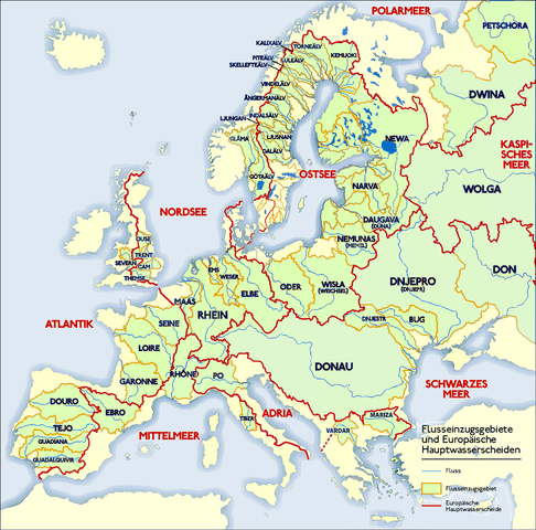
1190:- Klare Farben für klar eInformationen - Ladogasee und finnische Flüsse nachgetragen - Wasser aus den Kattegat-Zuflüssen fließt nicht in die Ostsee; Zuordnung des Kattegat zur Ostsee nautisch und mangels eigener Meereseinheit
731:
473:– You must give appropriate credit, provide a link to the license, and indicate if changes were made. You may do so in any reasonable manner, but not in any way that suggests the licensor endorses you or your use.
328:– You must give appropriate credit, provide a link to the license, and indicate if changes were made. You may do so in any reasonable manner, but not in any way that suggests the licensor endorses you or your use.
1340:
Drainage divide in Italy, Denmark, UK and
Gibraltar corrected. By the way: If someone have time and a better map than me, the doted line in Finnland should be replaced by "full line".
541:
909:
905:
901:
857:
1507:
1021:
853:
983:
897:
806:
810:
1273:
1243:
1213:
1849:
384:
650:
for more information. If an SVG form of this image is available, please upload it and afterwards replace this template with
56:
52:
48:
42:
1560:
552:
101:
912:"}},"text\/plain":{"en":{"P275":"Creative Commons Attribution-ShareAlike 3.0 Unported"}}}}": -->
647:
69:
1555:
1512:
193:
175:
154:
1448:
1083:
382:; with no Invariant Sections, no Front-Cover Texts, and no Back-Cover Texts. A copy of the license is included in the section entitled
265:
574:
969:
952:
935:
883:
596:
1412:
1407:
1382:
1377:
1352:
1347:
1322:
1317:
1292:
1287:
1262:
1257:
1232:
1227:
1202:
1197:
1172:
1167:
1310:
a small part of the Adria-Mittelmeer drainage was missing. But i don t have time to check exactly, thats why only doted line.
1472:
1468:
1464:
1107:
1103:
1099:
1460:
1456:
1095:
1091:
757:
739:
480:
335:
1031:
867:
667:
653:
374:
993:
919:
823:
839:
585:
1570:
727:
607:
530:
1600:
1440:
1075:
434:
297:
546:
563:
379:
1590:
1765:
1610:
479:– If you remix, transform, or build upon the material, you must distribute your contributions under the
334:– If you remix, transform, or build upon the material, you must distribute your contributions under the
1142:
1137:
860:"}},"text\/plain":{"en":{"P6216":"copyrighted"}}}}": -->
641:
60:
37:
1795:
1483:
The following pages on the
English Knowledge use this file (pages on other projects are not listed):
1497:
1280:
Grenze im Nord-Osten zwischen Newa und
Kemijoki verbessert. Gebiete westlich des Newas hinzugefügt.
753:
186:
168:
147:
109:
1502:
813:"}},"text\/plain":{"en":{"P180":"Europe"}}}}": -->
494:
372:
Permission is granted to copy, distribute and/or modify this document under the terms of the
557:
431:
294:
666:
It is recommended to name the SVG file “Europäische
Wasserscheiden.svg”—then the template
8:
1780:
254:
1625:
1492:
745:
579:
171:. The image is released under the Creative Commons Share Alike license for futher use.
150:. Bild ist unter der Creative Commons Share Alike zur weiteren Verwendung freigegeben.
1835:
1423:
738:
If you think this file should be featured on
Wikimedia Commons as well, feel free to
96:
219:
185:
Carte des bassins fluviaux d'Europe. Carte établie en juin 2004 par le contributeur
1840:
1333:
1303:
637:
1220:
Grenzen in Südschweden, im Osten von Dänemark und westliche Ostsee ergänzt (jetzt)
209:
1487:
1153:
749:
601:
1805:
1825:
1755:
1393:
671:
590:
144:
1250:
Grenzen in Südschweden, im Osten von Dänemark und westliche Ostsee ergänzt
612:
535:
1800:
1770:
1540:
1041:
1003:
963:
946:
929:
877:
833:
165:
The map shows the
European rivers' catchment areas and main watersheds.
1815:
1636:Списък на реките в Европа (водосборен басейн на Северния ледовит океан)
1183:
568:
1641:Списък на реките в Европа (водосборни басейни на безотточните области)
744:
If you have an image of similar quality that can be published under a
1820:
1715:
1620:
1363:
1631:Списък на реките в Европа (водосборен басейн на Атлантическия океан)
361:
1745:
1705:
1650:
1067:
Click on a date/time to view the file as it appeared at that time.
1775:
1695:
1685:
730:) and is considered one of the finest images. See its nomination
1830:
1810:
1790:
493:
This licensing tag was added to this file as part of the GFDL
1690:
1508:
Knowledge:Graphics Lab/Illustration workshop/Archive/Oct 2014
1660:
1545:
1785:
1750:
1730:
1530:
246:
Source: German
Knowledge, original upload see file history
1680:
236:
84:
1675:
1796:
1766:
Knowledge:Kandidaten für exzellente Bilder/Archiv2005/1
1580:
542:
1760:
1481:
74:(1,200 × 1,184 pixels, file size: 526 KB, MIME type:
1521:
1065:
970:
Creative Commons Attribution-ShareAlike 3.0 Unported
936:
GNU Free Documentation License, version 1.2 or later
910:
Creative Commons Attribution-ShareAlike 3.0 Unported
902:
GNU Free Documentation License, version 1.2 or later
799:
The main rivers of Europe and their catchment areas.
378:, Version 1.2 or any later version published by the
108:
Commons is a freely licensed media file repository.
1735:
953:
Creative Commons Attribution-ShareAlike 2.0 Generic
906:
Creative Commons Attribution-ShareAlike 2.0 Generic
689:
1740:
1725:
1670:
1710:
1430:Danube corrected, plus names of Vardar and Mariza
777:
690:
500:http://creativecommons.org/licenses/by-sa/3.0/
345:https://creativecommons.org/licenses/by-sa/2.0
89:
413:
351:Creative Commons Attribution-Share Alike 2.0
275:
260:
232:
131:
1781:Portal Diskussion:Geographie/Bild des Monats
521:
506:Creative Commons Attribution-Share Alike 3.0
250:
242:
174:Reference and sources can be requested from
14:
1513:Knowledge talk:WikiProject Rivers/Archive 3
456:– to copy, distribute and transmit the work
311:– to copy, distribute and transmit the work
1523:The following other wikis use this file:
1836:Benutzer Diskussion:Watzmann/Archiv/2013
646:. This has several advantages; see
192:Sources (!) disponibles par demande à
1841:Lichtenstein (Gemeinde Schenkenfelden)
553:Europäische Wasserscheiden Danube.png
120:
618:
435:Attribution-Share Alike 3.0 Unported
408:
390:http://www.gnu.org/copyleft/fdl.html
1058:
424:
419:
298:Attribution-Share Alike 2.0 Generic
286:
281:
13:
804:
798:
726:on the German language Knowledge (
629:
272:
179:
159:
138:
121:
67:
1861:
1826:Benutzer:Mikullovci11/Work/Karten
1597:Usage on be-tarask.wikipedia.org
803:
708:
575:Europäische-Wasserscheiden-NO.jpg
1482:
789:
717:
707:
622:
611:
600:
597:Wasserscheide Nordsee Ostsee.PNG
589:
578:
567:
556:
545:
534:
467:Under the following conditions:
430:This file is licensed under the
423:
418:
412:
366:
365:
322:Under the following conditions:
293:This file is licensed under the
285:
280:
274:
88:
31:
21:
786:
526:Derivative works of this file:
160:
146:Zeichnung erstellt 06/2004 von
1806:Europäische Hauptwasserscheide
1518:
1062:
785:
396:GNU Free Documentation License
385:GNU Free Documentation License
375:GNU Free Documentation License
180:
139:
134:Europäische Wasserscheiden.png
26:
1:
778:File history German Knowledge
216:Europäische Hauptwassercheide
1478:
819:Items portrayed in this file
7:
1771:Wasserscheiden in den Alpen
1756:Liste von Flüssen in Europa
1657:Usage on ceb.wikipedia.org
1567:Usage on arz.wikipedia.org
1537:Usage on als.wikipedia.org
153:Quellenangabe und Beleg an
10:
1866:
1816:Benutzer:NatiSythen/Karten
1722:Usage on de.wikipedia.org
1702:Usage on da.wikipedia.org
1667:Usage on cs.wikipedia.org
1647:Usage on bs.wikipedia.org
1617:Usage on bg.wikipedia.org
1607:Usage on be.wikipedia.org
1587:Usage on ba.wikipedia.org
1577:Usage on az.wikipedia.org
1552:Usage on ar.wikipedia.org
1541:Einzugsgebiet (Hydrologie)
1527:Usage on af.wikipedia.org
1400:Remove watermark, pngcrush
746:suitable copyright license
694:
634:image could be re-created
586:Main chain of the Alps.jpg
481:same or compatible license
336:same or compatible license
128:
123:
1059:
705:
701:
648:Commons:Media for cleanup
608:Lignedepartagedeseaux.png
531:Lignedepartagedeseaux.png
439:
411:
167:Chart made on 06/2004 by
16:
1821:Benutzer:WA1TF0R/Galerie
1498:List of rivers of Europe
788:
668:Vector version available
654:vector version available
380:Free Software Foundation
302:
95:This is a file from the
36:
1801:Diskussion:Schartenhöhe
1429:
1399:
1378:14:44, 24 February 2010
1369:
1339:
1309:
1279:
1249:
1219:
1189:
1159:
235:
99:. Information from its
1651:Spisak rijeka u Evropi
1503:Nature Restoration Law
1258:20:21, 16 January 2016
1228:21:59, 16 January 2016
1198:22:03, 16 January 2016
564:Euroopa veelahkmed.png
102:description page there
41:Size of this preview:
1776:Benutzer:Alopex/Tipps
1348:13:59, 7 January 2011
1696:Geografie Chorvatska
1318:18:14, 11 March 2011
1288:19:12, 11 March 2011
674:) does not need the
61:1,200 × 1,184 pixels
1716:Europæiske vandskel
1138:08:45, 31 July 2019
462:– to adapt the work
317:– to adapt the work
47:Other resolutions:
1831:Benutzer:Wesn/todo
1811:Wasserscheidepunkt
1791:Geographie Europas
1561:قائمة أنهار أوروبا
1493:European watershed
1408:19:26, 2 July 2009
1168:01:21, 16 May 2016
1850:more global usage
1746:Elbe-Lübeck-Kanal
1706:Europæiske floder
1556:خط التصريف المائي
1519:Global file usage
1433:
920:copyright license
898:copyright license
797:
774:
773:
770:
769:
766:
765:
728:Exzellente Bilder
687:
686:
683:
682:
517:
516:
407:
406:
269:
266:Reusing this file
206:Flußeinzugsgebiet
117:
116:
97:Wikimedia Commons
32:Global file usage
1857:
1691:Geografie Srbska
1454:
1446:
1438:
1420:
1390:
1360:
1330:
1300:
1270:
1240:
1210:
1180:
1150:
1112:
1089:
1081:
1073:
868:copyright status
854:copyright status
795:
724:featured picture
722: This is a
721:
720:
711:
710:
699:
698:
695:
691:
661:
626:
625:
619:
615:
604:
593:
582:
571:
560:
549:
538:
513:
510:
507:
504:
501:
498:
495:licensing update
483:as the original.
432:Creative Commons
427:
426:
422:
421:
416:
415:
409:
403:
400:
397:
394:
391:
369:
368:
362:
358:
355:
352:
349:
346:
338:as the original.
295:Creative Commons
289:
288:
284:
283:
278:
277:
263:
238:
220:drainage divides
218:= European main
212:= Bassin fluvial
202:= River = Fleuve
184:
182:Français :
164:
143:
135:
129:
113:
92:
91:
85:
79:
77:
64:
57:778 × 768 pixels
53:486 × 480 pixels
49:243 × 240 pixels
43:608 × 600 pixels
1865:
1864:
1860:
1859:
1858:
1856:
1855:
1854:
1686:Geografie Česka
1517:
1488:Drainage divide
1484:
1477:
1476:
1452:
1444:
1436:
1426:
1418:
1396:
1388:
1366:
1358:
1336:
1328:
1306:
1298:
1276:
1275:Francis McLloyd
1268:
1246:
1245:Francis McLloyd
1238:
1216:
1215:Francis McLloyd
1208:
1186:
1178:
1156:
1148:
1111:
1087:
1079:
1071:
1061:
1060:
1057:
1056:
1055:
1054:
1053:
1052:
1051:
1050:
1048:
1038:
1037:
1036:
1034:
1019:
1018:
1017:
1016:
1015:
1014:
1013:
1012:
1010:
1000:
999:
998:
996:
981:
980:
979:
978:
977:
976:
975:
974:
972:
961:
960:
959:
958:
957:
955:
944:
943:
942:
941:
940:
938:
926:
925:
924:
922:
895:
894:
893:
892:
891:
890:
889:
888:
886:
874:
873:
872:
870:
851:
850:
849:
848:
847:
846:
845:
844:
842:
830:
829:
828:
826:
802:
801:
800:
783:
780:
775:
718:
688:
679:
651:
638:vector graphics
623:
511:
508:
505:
502:
499:
492:
401:
398:
395:
392:
389:
360:
359:
356:
353:
350:
347:
344:
343:
301:
290:
189:
178:
158:
133:
126:
119:
118:
107:
106:
105:is shown below.
81:
75:
73:
66:
65:
46:
12:
11:
5:
1863:
1852:of this file.
1846:
1845:
1844:
1843:
1838:
1833:
1828:
1823:
1818:
1813:
1808:
1803:
1798:
1793:
1788:
1783:
1778:
1773:
1768:
1763:
1758:
1753:
1748:
1743:
1738:
1733:
1728:
1720:
1719:
1718:
1713:
1708:
1700:
1699:
1698:
1693:
1688:
1683:
1678:
1673:
1665:
1664:
1663:
1655:
1654:
1653:
1645:
1644:
1643:
1638:
1633:
1628:
1623:
1615:
1614:
1613:
1605:
1604:
1603:
1595:
1594:
1593:
1585:
1584:
1583:
1575:
1574:
1573:
1565:
1564:
1563:
1558:
1550:
1549:
1548:
1543:
1535:
1534:
1533:
1520:
1516:
1515:
1510:
1505:
1500:
1495:
1490:
1480:
1434:
1432:
1431:
1428:
1424:
1421:
1417:1,200 × 1,184
1415:
1410:
1405:
1402:
1401:
1398:
1394:
1391:
1387:1,200 × 1,184
1385:
1380:
1375:
1372:
1371:
1368:
1364:
1361:
1357:1,200 × 1,184
1355:
1350:
1345:
1342:
1341:
1338:
1334:
1331:
1327:1,200 × 1,184
1325:
1320:
1315:
1312:
1311:
1308:
1304:
1301:
1297:1,200 × 1,184
1295:
1290:
1285:
1282:
1281:
1278:
1274:
1271:
1267:1,200 × 1,184
1265:
1260:
1255:
1252:
1251:
1248:
1244:
1241:
1237:1,200 × 1,184
1235:
1230:
1225:
1222:
1221:
1218:
1214:
1211:
1207:1,200 × 1,184
1205:
1200:
1195:
1192:
1191:
1188:
1184:
1181:
1177:1,200 × 1,184
1175:
1170:
1165:
1162:
1161:
1158:
1154:
1151:
1147:1,200 × 1,184
1145:
1140:
1135:
1131:
1130:
1127:
1124:
1121:
1118:
1115:
1069:
1064:
1049:
1046:
1044:
1043:
1042:
1040:
1039:
1035:
1030:
1028:
1027:
1026:
1025:
1023:
1011:
1008:
1006:
1005:
1004:
1002:
1001:
997:
992:
990:
989:
988:
987:
985:
973:
968:
966:
965:
964:
962:
956:
951:
949:
948:
947:
945:
939:
934:
932:
931:
930:
928:
927:
923:
918:
916:
915:
914:
913:
911:
907:
903:
899:
887:
882:
880:
879:
878:
876:
875:
871:
866:
864:
863:
862:
861:
859:
855:
843:
838:
836:
835:
834:
832:
831:
827:
822:
820:
817:
816:
815:
814:
812:
808:
794:
793:
790:
787:
781:
779:
776:
772:
771:
768:
767:
764:
763:
714:
713:
704:
702:
685:
684:
681:
680:
676:new image name
658:new image name
627:
617:
616:
605:
594:
583:
572:
561:
550:
539:
523:
522:Other versions
519:
518:
515:
514:
489:
488:
487:
486:
485:
484:
474:
465:
464:
463:
457:
450:You are free:
445:
444:
441:
440:
438:
428:
405:
404:
370:
342:
341:
340:
339:
329:
320:
319:
318:
312:
305:You are free:
292:
291:
273:
270:
258:
257:
252:
248:
247:
244:
240:
239:
234:
230:
229:
228:
227:
213:
210:drainage basin
203:
187:de:Sansculotte
169:de:Sansculotte
136:
127:
125:
122:
115:
114:
93:
83:
82:
40:
35:
34:
29:
24:
19:
9:
6:
4:
3:
2:
1862:
1853:
1851:
1842:
1839:
1837:
1834:
1832:
1829:
1827:
1824:
1822:
1819:
1817:
1814:
1812:
1809:
1807:
1804:
1802:
1799:
1797:
1794:
1792:
1789:
1787:
1786:Einzugsgebiet
1784:
1782:
1779:
1777:
1774:
1772:
1769:
1767:
1764:
1762:
1759:
1757:
1754:
1752:
1751:Wasserscheide
1749:
1747:
1744:
1742:
1739:
1737:
1734:
1732:
1731:Niedersachsen
1729:
1727:
1724:
1723:
1721:
1717:
1714:
1712:
1709:
1707:
1704:
1703:
1701:
1697:
1694:
1692:
1689:
1687:
1684:
1682:
1679:
1677:
1674:
1672:
1669:
1668:
1666:
1662:
1661:Tubig-saluran
1659:
1658:
1656:
1652:
1649:
1648:
1646:
1642:
1639:
1637:
1634:
1632:
1629:
1627:
1624:
1622:
1619:
1618:
1616:
1612:
1609:
1608:
1606:
1602:
1599:
1598:
1596:
1592:
1589:
1588:
1586:
1582:
1579:
1578:
1576:
1572:
1569:
1568:
1566:
1562:
1559:
1557:
1554:
1553:
1551:
1547:
1546:Wasserscheide
1544:
1542:
1539:
1538:
1536:
1532:
1531:Waterskeiding
1529:
1528:
1526:
1525:
1524:
1514:
1511:
1509:
1506:
1504:
1501:
1499:
1496:
1494:
1491:
1489:
1486:
1485:
1474:
1470:
1466:
1462:
1458:
1450:
1442:
1427:
1422:
1416:
1414:
1411:
1409:
1406:
1404:
1403:
1397:
1392:
1386:
1384:
1381:
1379:
1376:
1374:
1373:
1367:
1362:
1356:
1354:
1351:
1349:
1346:
1344:
1343:
1337:
1332:
1326:
1324:
1321:
1319:
1316:
1314:
1313:
1307:
1302:
1296:
1294:
1291:
1289:
1286:
1284:
1283:
1277:
1272:
1266:
1264:
1261:
1259:
1256:
1254:
1253:
1247:
1242:
1236:
1234:
1231:
1229:
1226:
1224:
1223:
1217:
1212:
1206:
1204:
1201:
1199:
1196:
1194:
1193:
1187:
1182:
1176:
1174:
1171:
1169:
1166:
1164:
1163:
1157:
1152:
1146:
1144:
1141:
1139:
1136:
1133:
1132:
1128:
1125:
1122:
1119:
1116:
1114:
1113:
1109:
1105:
1101:
1097:
1093:
1085:
1077:
1068:
1045:
1033:
1029:
1007:
995:
991:
971:
967:
954:
950:
937:
933:
921:
917:
885:
881:
869:
865:
841:
837:
825:
821:
818:
791:
784:
762:
761:
759:
755:
751:
748:, be sure to
747:
743:
741:
736:
735:
733:
729:
725:
716:
715:
712:
703:
700:
697:
696:
693:
692:
677:
673:
669:
665:
664:
659:
655:
649:
645:
643:
639:
633:
628:
621:
620:
614:
609:
606:
603:
598:
595:
592:
587:
584:
581:
576:
573:
570:
565:
562:
559:
554:
551:
548:
543:
540:
537:
532:
529:
528:
527:
524:
520:
496:
491:
490:
482:
478:
475:
472:
469:
468:
466:
461:
458:
455:
452:
451:
449:
448:
447:
446:
443:
442:
436:
433:
429:
417:
410:
387:
386:
381:
377:
376:
371:
364:
363:
348:CC BY-SA 2.0
337:
333:
330:
327:
324:
323:
321:
316:
313:
310:
307:
306:
304:
303:
299:
296:
279:
271:
267:
262:
259:
256:
253:
249:
245:
241:
231:
225:
221:
217:
214:
211:
207:
204:
201:
198:
197:
196:
195:
194:
188:
183:
177:
176:
172:
170:
163:
157:
155:
151:
149:
142:
137:
130:
111:
104:
103:
98:
94:
87:
86:
80:
71:
70:Original file
62:
58:
54:
50:
44:
39:
33:
30:
28:
25:
23:
20:
18:
15:
1847:
1571:انهار اوروبا
1522:
1425:NordNordWest
1160:entschleiert
1066:
1063:File history
737:
723:
706:
675:
663:
657:
635:
631:
525:
503:CC BY-SA 3.0
476:
470:
459:
453:
383:
373:
331:
325:
314:
308:
223:
215:
205:
199:
191:
190:
181:
173:
166:
161:
152:
145:
140:
110:You can help
100:
68:
22:File history
1591:Һыу айырғыс
1335:W like wiki
1305:W like wiki
1009:3 June 2004
884:copyrighted
858:copyrighted
758:nominate it
740:nominate it
477:share alike
471:attribution
332:share alike
326:attribution
255:Sansculotte
237:3 June 2004
148:Sansculotte
132:Description
1611:Водападзел
1601:Водападзел
1581:Axar-baxar
1479:File usage
1370:Saimaa fix
1155:1970gemini
1123:Dimensions
1032:media type
1022:media type
678:parameter.
261:Permission
224:watersheds
27:File usage
1120:Thumbnail
1117:Date/Time
1047:image/png
994:inception
984:inception
437:license.
162:English:
141:Deutsch:
76:image/png
1761:Dietweis
1449:older 10
1445:newer 10
1443:) View (
1419:(552 KB)
1395:Dcoetzee
1389:(564 KB)
1359:(849 KB)
1329:(724 KB)
1299:(723 KB)
1269:(760 KB)
1239:(763 KB)
1209:(766 KB)
1179:(279 KB)
1149:(526 KB)
1084:older 10
1080:newer 10
1078:) View (
792:Captions
756:it, and
460:to remix
454:to share
315:to remix
309:to share
300:license.
208:= River
156:erbeten.
1681:Rozvodí
1626:Вододел
1134:current
1129:Comment
824:depicts
807:depicts
796:English
632:geology
610::
599::
588::
577::
566::
555::
544::
533::
124:Summary
72:
1736:Ostsee
1676:Povodí
1441:oldest
1437:newest
1076:oldest
1072:newest
840:Europe
811:Europe
750:upload
640:as an
636:using
251:Author
243:Source
1848:View
1741:Rhein
1726:Donau
1671:Dunaj
1185:Ulamm
630:This
222:(GB:
1711:Lviv
1621:Рейн
1365:Care
1126:User
752:it,
732:here
670:(or
644:file
512:true
509:true
402:true
399:true
393:GFDL
357:true
354:true
233:Date
200:Fluß
17:File
1473:500
1469:250
1465:100
1451:) (
1447:|
1108:500
1104:250
1100:100
1086:) (
1082:|
754:tag
672:Vva
642:SVG
1471:|
1467:|
1463:|
1461:50
1459:|
1457:20
1455:|
1453:10
1439:|
1106:|
1102:|
1098:|
1096:50
1094:|
1092:20
1090:|
1088:10
1074:|
660:}}
652:{{
59:|
55:|
51:|
45:.
1475:)
1435:(
1110:)
1070:(
760:.
742:.
734:.
662:.
656:|
497:.
388:.
268:)
264:(
226:)
112:.
78:)
63:.
Text is available under the Creative Commons Attribution-ShareAlike License. Additional terms may apply.
