332:
479:"}},"text\/plain":{"en":{"":"inception"}}},"{\"value\":{\"time\":\"+2010-03-28T00:00:00Z\",\"timezone\":0,\"before\":0,\"after\":0,\"precision\":11,\"calendarmodel\":\"http:\\\/\\\/www.wikidata.org\\\/entity\\\/Q1985727\"},\"type\":\"time\"}":{"text\/html":{"en":{"P571":"28 March 2010"}},"text\/plain":{"en":{"P571":"28 March 2010"}}}}": -->
38:
244:
250:
94:
1007:
1002:
517:"}},"text\/plain":{"en":{"":"media type"}}},"{\"value\":\"image\\\/jpeg\",\"type\":\"string\"}":{"text\/html":{"en":{"P1163":"image\/jpeg"}},"text\/plain":{"en":{"P1163":"image\/jpeg"}}}}": -->
435:"}},"text\/plain":{"en":{"":"copyright license"}}},"{\"value\":{\"entity-type\":\"item\",\"numeric-id\":14947546,\"id\":\"Q14947546\"},\"type\":\"wikibase-entityid\"}":{"text\/html":{"en":{"P275":"
391:"}},"text\/plain":{"en":{"":"copyright status"}}},"{\"value\":{\"entity-type\":\"item\",\"numeric-id\":50423863,\"id\":\"Q50423863\"},\"type\":\"wikibase-entityid\"}":{"text\/html":{"en":{"P6216":"
513:
593:
640:{{Information |Description={{de|Physische Positionskarte von {{w|Osttimor|3=de}}}} Quadratische Plattkarte. Geographische Begrenzung der Karte: * N: 7.8° S * S: 10.0° S * W: 123.9° O * O: 127.5° O {{en|Physical location map of {{w|East Timor}}}} Equir
1062:
1047:
291:– You must give appropriate credit, provide a link to the license, and indicate if changes were made. You may do so in any reasonable manner, but not in any way that suggests the licensor endorses you or your use.
882:
947:
977:
854:
849:
844:
436:
392:
992:
514:
388:
476:
432:
1216:
60:
56:
52:
48:
42:
829:
784:
105:
633:
73:
233:
439:"}},"text\/plain":{"en":{"P275":"Creative Commons Attribution 3.0 Unported"}}}}": -->
864:
462:
418:
622:
617:
331:
859:
524:
402:
486:
446:
377:
1027:
897:
1057:
892:
967:
260:
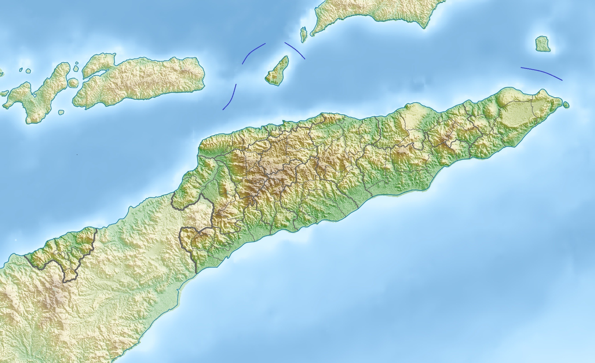
214:, using map data from administrative map by NordNordWest. The relief was created from SRTM-3 relief data
912:
395:"}},"text\/plain":{"en":{"P6216":"copyrighted"}}}}": -->
323:
962:
650:
The following pages on the
English Knowledge use this file (pages on other projects are not listed):
592:
587:
64:
37:
113:
957:
1177:
1017:
610:
Borders between islands marked in reference to the map "File:Vychodni Timor.png";
257:
8:
1072:
1127:
659:
654:
1137:
799:
759:
100:
367:
774:
694:
674:
1087:
764:
907:
794:
1037:
729:
684:
664:
1107:
754:
714:
679:
222:
1142:
937:
839:
804:
769:
724:
689:
603:
789:
719:
669:
534:
496:
456:
412:
173:
144:
834:
824:
814:
749:
734:
709:
1192:
987:
819:
704:
699:
855:
User:Ty654/List of earthquakes from 1960-1964 exceeding magnitude 6+
850:
User:Ty654/List of earthquakes from 1955-1959 exceeding magnitude 6+
845:
User:Ty654/List of earthquakes from 1950-1954 exceeding magnitude 6+
809:
779:
744:
739:
560:
Click on a date/time to view the file as it appeared at that time.
1207:
1202:
1112:
1167:
1147:
922:
1028:
Resolució 1480 del
Consell de Seguretat de les Nacions Unides
150:
Quadratische
Plattkarte. Geographische Begrenzung der Karte:
1102:
917:
968:
Module:Mapa nin kinamumugtakan/datos/Subangan na Timor/doc
178:
Equirectangular projection. Geographic limits of the map:
201:
88:
1182:
1157:
1152:
1117:
1077:
927:
361:
Add a one-line explanation of what this file represents
963:
Module:Mapa nin kinamumugtakan/datos/Subangan na Timor
1187:
1162:
1122:
1097:
898:
Módulu:Mapa de llocalización/datos/Timor
Oriental/usu
648:
78:(2,000 × 1,223 pixels, file size: 657 KB, MIME type:
1197:
1172:
873:
558:
112:
Commons is a freely licensed media file repository.
1132:
893:Módulu:Mapa de llocalización/datos/Timor Oriental
1178:Knowledge:Kartenwerkstatt/Positionskarten/Asien
958:Module:Mapa nin kinamumugtakan/datos/East Timor
830:United Nations Security Council Resolution 1480
785:Presidente Nicolau Lobato International Airport
93:
1008:মডিউল:অবস্থান মানচিত্র/উপাত্ত/পূর্ব তিমুর/নথি
243:
228:
197:
130:
317:
218:
207:
14:
298:https://creativecommons.org/licenses/by/3.0
274:– to copy, distribute and transmit the work
1003:মডিউল:অবস্থান মানচিত্র/উপাত্ত/পূর্ব তিমুর
875:The following other wikis use this file:
463:Creative Commons Attribution 3.0 Unported
437:Creative Commons Attribution 3.0 Unported
1138:Vorlage Diskussion:Infobox Berg/Archiv/1
865:Module:Location map/data/East Timor/doc
1128:Benutzer:J. Patrick Fischer/Nützliches
1018:Šablon:Lokacijska karta Istočni Timor
322:Derivative works of this file:
124:
860:Module:Location map/data/East Timor
551:
249:
13:
1048:Кеп:Меттиган карта Малхбален Тимор
366:
360:
265:
240:
166:
137:
133:East Timor relief location map.jpg
125:
71:
1228:
1063:بڕیارنامەی ١٤٨٠ی ئەنجومەنی ئاسایش
1038:Plantilya:Location map East Timor
365:
304:Creative Commons Attribution 3.0
1088:Skabelon:Kortpositioner Østtimor
649:
351:
330:
285:Under the following conditions:
256:This file is licensed under the
248:
242:
92:
31:
21:
1143:Vorlage:Positionskarte Osttimor
913:Şablon:Yer xəritəsi Şərqi Timor
348:
167:
1058:داڕێژە:Location map East Timor
938:Vorlog:Positionskarte Osttimor
908:Nino Konis Santana Milli Parkı
883:قالب:خريطة مواقع تيمور الشرقية
870:
555:
347:
138:
26:
1:
1073:Šablona:LocMap Východní Timor
978:Шаблон:На карце/Усходні Тымор
948:Ҡалып:ПозКарта Көнсығыш Тимор
337:Equivalent administrative map
143:Physische Positionskarte von
1108:Liste der Städte in Osttimor
645:
373:Items portrayed in this file
7:
1054:Usage on ckb.wikipedia.org
1034:Usage on ceb.wikipedia.org
954:Usage on bcl.wikipedia.org
934:Usage on bar.wikipedia.org
889:Usage on ast.wikipedia.org
10:
1233:
1094:Usage on de.wikipedia.org
1084:Usage on da.wikipedia.org
1069:Usage on cs.wikipedia.org
1044:Usage on ce.wikipedia.org
1024:Usage on ca.wikipedia.org
1014:Usage on bs.wikipedia.org
999:Usage on bn.wikipedia.org
984:Usage on bg.wikipedia.org
974:Usage on be.wikipedia.org
944:Usage on ba.wikipedia.org
904:Usage on az.wikipedia.org
879:Usage on ar.wikipedia.org
127:
552:
211:
172:Physical location map of
16:
1193:Benutzer:Carport/Galerie
350:
261:Attribution 3.0 Unported
99:This is a file from the
36:
993:Шаблон:ПК Източен Тимор
639:
609:
588:10:36, 17 November 2012
200:
147:, Grenzen von 2003–2015
103:. Information from its
106:description page there
41:Size of this preview:
1113:Geschichte Osttimors
618:09:26, 28 March 2010
65:2,000 × 1,223 pixels
1168:Monte Mundo Perdido
324:Fuiloro Plateau.jpg
280:– to adapt the work
47:Other resolutions:
1148:Kisar (Indonesien)
660:Bandeira Waterfall
655:Areia Branca Beach
61:1,280 × 783 pixels
57:1,024 × 626 pixels
1217:more global usage
871:Global file usage
800:South Laclo River
760:North Laclo River
643:
447:copyright license
433:copyright license
359:
344:
343:
237:
234:Reusing this file
121:
120:
101:Wikimedia Commons
32:Global file usage
1224:
1208:Straße von Wetar
1203:Straße von Ombai
775:One Dollar Beach
695:Cristo Rei Beach
675:Berloi Waterfall
630:
600:
562:
403:copyright status
389:copyright status
357:
334:
311:
308:
305:
302:
299:
258:Creative Commons
252:
251:
246:
245:
231:
213:
203:
171:
142:
134:
128:
117:
96:
95:
89:
83:
81:
68:
53:640 × 391 pixels
49:320 × 196 pixels
43:800 × 489 pixels
1232:
1231:
1227:
1226:
1225:
1223:
1222:
1221:
1103:Jaco (Osttimor)
869:
765:Oecusse Airport
651:
644:
636:
628:
606:
598:
554:
553:
550:
549:
548:
547:
546:
545:
544:
543:
541:
531:
530:
529:
527:
512:
511:
510:
509:
508:
507:
506:
505:
503:
493:
492:
491:
489:
474:
473:
472:
471:
470:
469:
468:
467:
465:
453:
452:
451:
449:
430:
429:
428:
427:
426:
425:
424:
423:
421:
409:
408:
407:
405:
386:
385:
384:
383:
382:
380:
364:
363:
362:
345:
338:
335:
313:
312:
309:
306:
303:
300:
297:
296:
264:
253:
176:
148:
132:
123:
122:
111:
110:
109:is shown below.
85:
79:
77:
70:
69:
46:
12:
11:
5:
1230:
1219:of this file.
1213:
1212:
1211:
1210:
1205:
1200:
1195:
1190:
1185:
1180:
1175:
1170:
1165:
1160:
1155:
1150:
1145:
1140:
1135:
1130:
1125:
1120:
1115:
1110:
1105:
1100:
1092:
1091:
1090:
1082:
1081:
1080:
1075:
1067:
1066:
1065:
1060:
1052:
1051:
1050:
1042:
1041:
1040:
1032:
1031:
1030:
1022:
1021:
1020:
1012:
1011:
1010:
1005:
997:
996:
995:
990:
982:
981:
980:
972:
971:
970:
965:
960:
952:
951:
950:
942:
941:
940:
932:
931:
930:
925:
920:
915:
910:
902:
901:
900:
895:
887:
886:
885:
872:
868:
867:
862:
857:
852:
847:
842:
837:
832:
827:
822:
817:
812:
807:
802:
797:
792:
787:
782:
777:
772:
767:
762:
757:
752:
747:
742:
737:
732:
730:Lene Hara cave
727:
722:
717:
712:
707:
702:
697:
692:
687:
685:Caraulun River
682:
677:
672:
667:
665:Baucau Airport
662:
657:
647:
642:
641:
638:
634:
631:
627:2,000 × 1,223
625:
620:
615:
612:
611:
608:
604:
601:
597:2,000 × 1,223
595:
590:
585:
581:
580:
577:
574:
571:
568:
565:
557:
542:
539:
537:
536:
535:
533:
532:
528:
523:
521:
520:
519:
518:
516:
504:
501:
499:
498:
497:
495:
494:
490:
485:
483:
482:
481:
480:
478:
466:
461:
459:
458:
457:
455:
454:
450:
445:
443:
442:
441:
440:
438:
434:
422:
417:
415:
414:
413:
411:
410:
406:
401:
399:
398:
397:
396:
394:
390:
381:
376:
374:
371:
370:
369:
368:
356:
355:
352:
349:
342:
341:
340:
339:
336:
329:
319:
318:Other versions
315:
314:
295:
294:
293:
292:
283:
282:
281:
275:
268:You are free:
255:
254:
241:
238:
226:
225:
220:
216:
215:
209:
205:
204:
199:
195:
194:
193:
192:
189:
186:
183:
165:
164:
161:
158:
155:
135:
126:
119:
118:
97:
87:
86:
40:
35:
34:
29:
24:
19:
9:
6:
4:
3:
2:
1229:
1220:
1218:
1209:
1206:
1204:
1201:
1199:
1196:
1194:
1191:
1189:
1186:
1184:
1181:
1179:
1176:
1174:
1171:
1169:
1166:
1164:
1161:
1159:
1156:
1154:
1151:
1149:
1146:
1144:
1141:
1139:
1136:
1134:
1131:
1129:
1126:
1124:
1121:
1119:
1116:
1114:
1111:
1109:
1106:
1104:
1101:
1099:
1096:
1095:
1093:
1089:
1086:
1085:
1083:
1079:
1076:
1074:
1071:
1070:
1068:
1064:
1061:
1059:
1056:
1055:
1053:
1049:
1046:
1045:
1043:
1039:
1036:
1035:
1033:
1029:
1026:
1025:
1023:
1019:
1016:
1015:
1013:
1009:
1006:
1004:
1001:
1000:
998:
994:
991:
989:
986:
985:
983:
979:
976:
975:
973:
969:
966:
964:
961:
959:
956:
955:
953:
949:
946:
945:
943:
939:
936:
935:
933:
929:
926:
924:
921:
919:
916:
914:
911:
909:
906:
905:
903:
899:
896:
894:
891:
890:
888:
884:
881:
880:
878:
877:
876:
866:
863:
861:
858:
856:
853:
851:
848:
846:
843:
841:
838:
836:
833:
831:
828:
826:
823:
821:
818:
816:
813:
811:
808:
806:
803:
801:
798:
796:
793:
791:
788:
786:
783:
781:
778:
776:
773:
771:
768:
766:
763:
761:
758:
756:
755:Mount Diatuto
753:
751:
748:
746:
743:
741:
738:
736:
733:
731:
728:
726:
723:
721:
718:
716:
715:Irabere River
713:
711:
708:
706:
703:
701:
698:
696:
693:
691:
688:
686:
683:
681:
680:Cape Fatucama
678:
676:
673:
671:
668:
666:
663:
661:
658:
656:
653:
652:
637:
632:
626:
624:
621:
619:
616:
614:
613:
607:
602:
596:
594:
591:
589:
586:
583:
582:
578:
575:
572:
569:
566:
564:
563:
561:
538:
526:
522:
502:28 March 2010
500:
488:
484:
464:
460:
448:
444:
420:
416:
404:
400:
379:
375:
372:
353:
346:
333:
328:
327:
326:
325:
320:
316:
290:
287:
286:
284:
279:
276:
273:
270:
269:
267:
266:
262:
259:
247:
239:
235:
230:
227:
224:
221:
217:
210:
206:
202:28 March 2010
196:
190:
187:
184:
181:
180:
179:
175:
170:
162:
159:
156:
153:
152:
151:
146:
141:
136:
129:
115:
108:
107:
102:
98:
91:
90:
84:
75:
74:Original file
66:
62:
58:
54:
50:
44:
39:
33:
30:
28:
25:
23:
20:
18:
15:
1214:
923:Atauro adası
874:
840:Wetar Strait
805:Suai Airport
795:Seiçal River
770:Ombai Strait
725:Laleia River
690:Comoro River
559:
556:File history
321:
288:
277:
271:
177:
168:
149:
139:
114:You can help
104:
72:
22:File history
1183:Curi (Berg)
790:Sahen River
720:Jaco Island
670:Bay of Dili
419:copyrighted
393:copyrighted
289:attribution
191:E: 127.5° E
188:W: 123.9° E
163:O: 127.5° O
160:W: 123.9° O
131:Description
1158:Maubarasee
1153:Ira Lalaro
1118:Tatamailau
1078:Tatamailau
928:Tatamaylau
918:Jaku adası
835:Valu Beach
825:Tono River
815:Tatamailau
750:Mount Curi
735:Loes River
710:Ira Lalaro
646:File usage
573:Dimensions
540:image/jpeg
525:media type
515:media type
301:CC BY 3.0
229:Permission
185:S: 10.0° S
174:East Timor
157:S: 10.0° S
80:image/jpeg
27:File usage
820:Tibar Bay
705:Fatumasin
700:Dolok Oan
570:Thumbnail
567:Date/Time
487:inception
477:inception
182:N: 7.8° S
169:English:
154:N: 7.8° S
140:Deutsch:
1188:Paitchau
1163:Tasitolu
1123:Matebian
1098:Osttimor
810:Tasitolu
780:Paitchau
745:Matebian
740:Manucoco
629:(748 KB)
599:(657 KB)
354:Captions
278:to remix
272:to share
263:license.
212:Own work
145:Osttimor
1198:Legumau
1173:Leolaco
635:Carport
605:Jaybear
584:current
579:Comment
378:depicts
358:English
223:Carport
76:
1133:Cablac
219:Author
208:Source
1215:View
988:Дили
576:User
310:true
307:true
198:Date
17:File
63:|
59:|
55:|
51:|
45:.
236:)
232:(
116:.
82:)
67:.
