865:"}},"text\/plain":{"en":{"":"coordinates of the point of view"}}},"{\"value\":{\"latitude\":51.8784,\"longitude\":-4.591,\"altitude\":null,\"precision\":0.0001,\"globe\":\"http:\\\/\\\/www.wikidata.org\\\/entity\\\/Q2\"},\"type\":\"globecoordinate\"}":{"text\/html":{"en":{"P1259":"51\u00b052'42.2"N, 4\u00b035'27.6"W"}},"text\/plain":{"en":{"P1259":"51\u00b052'42.2\"N, 4\u00b035'27.6\"W"}}},"{\"value\":{\"entity-type\":\"property\",\"numeric-id\":7787,\"id\":\"P7787\"},\"type\":\"wikibase-entityid\"}":{"text\/html":{"en":{"":"
933:"}},"text\/plain":{"en":{"":"coordinates of depicted place"}}},"{\"value\":{\"latitude\":51.8784,\"longitude\":-4.591,\"altitude\":null,\"precision\":0.0001,\"globe\":\"http:\\\/\\\/www.wikidata.org\\\/entity\\\/Q2\"},\"type\":\"globecoordinate\"}":{"text\/html":{"en":{"P9149":"51\u00b052'42.2"N, 4\u00b035'27.6"W"}},"text\/plain":{"en":{"P9149":"51\u00b052'42.2\"N, 4\u00b035'27.6\"W"}}},"{\"value\":{\"entity-type\":\"property\",\"numeric-id\":7787,\"id\":\"P7787\"},\"type\":\"wikibase-entityid\"}":{"text\/html":{"en":{"":"
517:"}},"text\/plain":{"en":{"":"author name string"}}},"{\"value\":\"Humphrey Bolton\",\"type\":\"string\"}":{"text\/html":{"en":{"P2093":"Humphrey Bolton"}},"text\/plain":{"en":{"P2093":"Humphrey Bolton"}}},"{\"value\":{\"entity-type\":\"property\",\"numeric-id\":2699,\"id\":\"P2699\"},\"type\":\"wikibase-entityid\"}":{"text\/html":{"en":{"":"
827:"}},"text\/plain":{"en":{"":"inception"}}},"{\"value\":{\"time\":\"+2007-10-04T00:00:00Z\",\"timezone\":0,\"before\":0,\"after\":0,\"precision\":11,\"calendarmodel\":\"http:\\\/\\\/www.wikidata.org\\\/entity\\\/Q1985727\"},\"type\":\"time\"}":{"text\/html":{"en":{"P571":"4 October 2007"}},"text\/plain":{"en":{"P571":"4 October 2007"}}}}": -->
704:
310:
260:
43:
929:
252:
324:
274:
345:
383:
388:
87:
525:"}},"text\/plain":{"en":{"P2699":"https:\/\/www.geograph.org.uk\/profile\/1712"}}},"{\"value\":{\"entity-type\":\"property\",\"numeric-id\":3831,\"id\":\"P3831\"},\"type\":\"wikibase-entityid\"}":{"text\/html":{"en":{"":"
712:"}},"text\/plain":{"en":{"P7482":"file available on the internet"}}},"{\"value\":{\"entity-type\":\"property\",\"numeric-id\":7384,\"id\":\"P7384\"},\"type\":\"wikibase-entityid\"}":{"text\/html":{"en":{"":"
529:"}},"text\/plain":{"en":{"":"object of statement has role"}}},"{\"value\":{\"entity-type\":\"item\",\"numeric-id\":33231,\"id\":\"Q33231\"},\"type\":\"wikibase-entityid\"}":{"text\/html":{"en":{"P3831":"
728:"}},"text\/plain":{"en":{"P137":"Geograph Britain and Ireland"}}},"{\"value\":{\"entity-type\":\"property\",\"numeric-id\":973,\"id\":\"P973\"},\"type\":\"wikibase-entityid\"}":{"text\/html":{"en":{"":"
1039:
664:"}},"text\/plain":{"en":{"":"copyright license"}}},"{\"value\":{\"entity-type\":\"item\",\"numeric-id\":19068220,\"id\":\"Q19068220\"},\"type\":\"wikibase-entityid\"}":{"text\/html":{"en":{"P275":"
620:"}},"text\/plain":{"en":{"":"copyright status"}}},"{\"value\":{\"entity-type\":\"item\",\"numeric-id\":50423863,\"id\":\"Q50423863\"},\"type\":\"wikibase-entityid\"}":{"text\/html":{"en":{"P6216":"
708:"}},"text\/plain":{"en":{"":"source of file"}}},"{\"value\":{\"entity-type\":\"item\",\"numeric-id\":74228490,\"id\":\"Q74228490\"},\"type\":\"wikibase-entityid\"}":{"text\/html":{"en":{"P7482":"
937:"}},"text\/plain":{"en":{"":"heading"}}},"{\"value\":{\"amount\":\"+225\",\"unit\":\"http:\\\/\\\/www.wikidata.org\\\/entity\\\/Q28390\"},\"type\":\"quantity\"}":{"text\/html":{"en":{"P7787":"225
869:"}},"text\/plain":{"en":{"":"heading"}}},"{\"value\":{\"amount\":\"+225\",\"unit\":\"http:\\\/\\\/www.wikidata.org\\\/entity\\\/Q28390\"},\"type\":\"quantity\"}":{"text\/html":{"en":{"P7787":"225
724:"}},"text\/plain":{"en":{"":"operator"}}},"{\"value\":{\"entity-type\":\"item\",\"numeric-id\":1503119,\"id\":\"Q1503119\"},\"type\":\"wikibase-entityid\"}":{"text\/html":{"en":{"P137":"
720:"}},"text\/plain":{"en":{"P7384":"602813"}}},"{\"value\":{\"entity-type\":\"property\",\"numeric-id\":137,\"id\":\"P137\"},\"type\":\"wikibase-entityid\"}":{"text\/html":{"en":{"":"
513:"}},"text\/plain":{"en":{"":"creator"}}},"{\"value\":{\"entity-type\":\"property\",\"numeric-id\":2093,\"id\":\"P2093\"},\"type\":\"wikibase-entityid\"}":{"text\/html":{"en":{"":"
616:
716:"}},"text\/plain":{"en":{"":"geograph.org.uk image ID"}}},"{\"value\":\"602813\",\"type\":\"string\"}":{"text\/html":{"en":{"P7384":"
243:
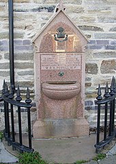
1056:== {{int:filedesc}} == {{Information |description={{en|1=Drinking Fountain, Llanboidy Outside the village hall, and inscribed This fountain is erected to commemorate the completion of the work for supplying this village with water in compliance with the
435:– You must give appropriate credit, provide a link to the license, and indicate if changes were made. You may do so in any reasonable manner, but not in any way that suggests the licensor endorses you or your use.
53:
47:
307:
257:
98:
66:
717:
709:
665:
621:
725:
530:
934:
930:
866:
862:
713:
705:
617:
526:
518:
514:
824:
733:
729:
721:
661:
522:
510:
1049:
668:"}},"text\/plain":{"en":{"P275":"Creative Commons Attribution-ShareAlike 2.0 Generic"}}}}": -->
736:"}},"text\/plain":{"en":{"P973":"https:\/\/www.geograph.org.uk\/photo\/602813"}}}}": -->
759:
691:
647:
317:
267:
1038:
1033:
57:
42:
794:
352:
1106:
This file contains additional information, probably added from the digital camera or scanner used to create or digitize it.
442:
602:
975:
948:
907:
880:
772:
743:
631:
595:
580:
567:
834:
802:
787:
675:
540:
499:
398:
1109:
If the file has been modified from its original state, some details may not fully reflect the modified file.
441:– If you remix, transform, or build upon the material, you must distribute your contributions under the
359:
on the
Geograph website for the photographer's contact details. The copyright on this image is owned by
533:"}},"text\/plain":{"en":{"P3831":"photographer"}}}}": -->
624:"}},"text\/plain":{"en":{"P6216":"copyrighted"}}}}": -->
1066:
The following pages on the
English Knowledge use this file (pages on other projects are not listed):
941:"}},"text\/plain":{"en":{"P7787":"225 degree"}}}}": -->
873:"}},"text\/plain":{"en":{"P7787":"225 degree"}}}}": -->
106:
199:
809:
779:
587:
395:
183:
142:
supply and sewerage system was installed in 1890, the first piped water in
Carmarthenshire.
8:
339:
323:
273:
1088:
364:
93:
489:
1070:
226:
172:
162:
958:
890:
844:
753:
685:
641:
550:
344:
1093:
356:
1006:
Click on a date/time to view the file as it appeared at that time.
309:
259:
131:
Drinking
Fountain, Llanboidy - geograph.org.uk - 602813.jpg
294:
51° 52′ 42″ N, 4° 35′ 28″ W
244:
51° 52′ 42″ N, 4° 35′ 28″ W
151:
81:
483:
Add a one-line explanation of what this file represents
1064:
1079:
1004:
105:
Commons is a freely licensed media file repository.
692:
Creative
Commons Attribution-ShareAlike 2.0 Generic
666:
Creative
Commons Attribution-ShareAlike 2.0 Generic
71:(455 × 640 pixels, file size: 95 KB, MIME type:
452:https://creativecommons.org/licenses/by-sa/2.0
86:
458:Creative Commons Attribution-Share Alike 2.0
376:
147:
128:
734:https:\/\/www.geograph.org.uk\/photo\/602813
523:https:\/\/www.geograph.org.uk\/profile\/1712
168:
157:
14:
938:
870:
418:– to copy, distribute and transmit the work
1089:Siryfion Sir Gaerfyrddin yn y 19eg ganrif
1081:The following other wikis use this file:
810:https://www.geograph.org.uk/photo/602813
588:https://www.geograph.org.uk/profile/1712
316:View this and other nearby images on:
266:View this and other nearby images on:
206:
117:
363:and is licensed for reuse under the
284:
234:
997:
399:Attribution-Share Alike 2.0 Generic
387:
382:
367:Attribution-ShareAlike 2.0 license.
13:
1104:
488:
482:
373:
350:
135:
118:
64:
1130:
1111:
487:
1065:
881:coordinates of the point of view
863:coordinates of the point of view
473:
429:Under the following conditions:
394:This file is licensed under the
386:
381:
375:
343:
322:
308:
300:
272:
258:
250:
85:
31:
21:
470:
136:
1076:
1001:
760:file available on the internet
710:file available on the internet
469:
351:This image was taken from the
26:
1:
949:coordinates of depicted place
931:coordinates of depicted place
36:
1061:
795:Geograph Britain and Ireland
726:Geograph Britain and Ireland
596:object of statement has role
527:object of statement has role
495:Items portrayed in this file
335:
299:
249:
214:Drinking Fountain, Llanboidy
212:Humphrey Bolton /
195:Drinking Fountain, Llanboidy
193:Humphrey Bolton /
7:
1101:
10:
1135:
1085:Usage on cy.wikipedia.org
443:same or compatible license
125:
120:
1094:Walter Rice Howell Powell
998:
964:51°52'42.2"N, 4°35'27.6"W
896:51°52'42.2"N, 4°35'27.6"W
16:
773:geograph.org.uk image ID
714:geograph.org.uk image ID
472:
409:
92:This is a file from the
41:
1055:
184:required by the license
150:
96:. Information from its
1034:22:57, 6 February 2011
357:this photograph's page
328:51.878400; -4.591000
278:51.878400; -4.591000
227:Link to Openstreetmap
99:description page there
46:Size of this preview:
424:– to adapt the work
220:Openstreetmap entry
52:Other resolutions:
568:author name string
515:author name string
1122:
1121:
1077:Global file usage
1059:
940:
872:
676:copyright license
662:copyright license
481:
372:
371:
355:collection. See
333:
332:
283:
282:
232:
231:
187:
114:
113:
94:Wikimedia Commons
32:Global file usage
1126:
1112:
1046:
1008:
986:
985:
980:
918:
917:
912:
812:
807:
803:described at URL
797:
792:
782:
777:
730:described at URL
632:copyright status
618:copyright status
605:
600:
590:
585:
575:
572:
479:
465:
462:
459:
456:
453:
445:as the original.
407:
396:Creative Commons
390:
389:
385:
384:
379:
378:
365:Creative Commons
353:Geograph project
347:
340:
329:
326:
312:
311:
305:
304:
303:
297:
296:
285:
279:
276:
262:
261:
255:
254:
253:
247:
246:
235:
181:
153:
140:
132:
126:
110:
89:
88:
82:
76:
74:
61:
58:455 × 640 pixels
54:170 × 240 pixels
48:426 × 599 pixels
1134:
1133:
1129:
1128:
1127:
1125:
1124:
1123:
1100:
1075:
1071:W. R. H. Powell
1067:
1060:
1052:
1044:
1000:
999:
996:
995:
994:
993:
992:
991:
990:
989:
988:
987:
983:
981:
978:
969:
968:
967:
965:
955:
954:
953:
951:
928:
927:
926:
925:
924:
923:
922:
921:
920:
919:
915:
913:
910:
901:
900:
899:
897:
887:
886:
885:
883:
860:
859:
858:
857:
856:
855:
854:
853:
851:
841:
840:
839:
837:
822:
821:
820:
819:
818:
817:
816:
815:
814:
813:
808:
805:
799:
798:
793:
790:
784:
783:
778:
775:
766:
765:
764:
762:
750:
749:
748:
746:
703:
702:
701:
700:
699:
698:
697:
696:
694:
682:
681:
680:
678:
659:
658:
657:
656:
655:
654:
653:
652:
650:
638:
637:
636:
634:
615:
614:
613:
612:
611:
610:
609:
608:
607:
606:
601:
598:
592:
591:
586:
583:
577:
576:
574:Humphrey Bolton
573:
570:
561:
560:
559:
557:
547:
546:
545:
543:
508:
507:
506:
505:
504:
502:
486:
485:
484:
467:
466:
463:
460:
457:
454:
451:
450:
408:
406:Humphrey Bolton
405:
402:
391:
368:
361:Humphrey Bolton
338:
327:
301:
292:
291:
288:Object location
277:
251:
242:
241:
238:Camera location
233:
223:
209:
202:
190:
173:Humphrey Bolton
163:geograph.org.uk
143:
130:
123:
116:
115:
104:
103:
102:is shown below.
78:
72:
70:
63:
62:
51:
12:
11:
5:
1132:
1120:
1119:
1116:
1103:
1099:
1098:
1097:
1096:
1091:
1078:
1074:
1073:
1063:
1058:
1057:
1054:
1050:
1047:
1041:
1036:
1031:
1027:
1026:
1023:
1020:
1017:
1014:
1011:
1003:
974:
973:
972:
971:
970:
966:
963:
961:
960:
959:
957:
956:
952:
947:
945:
944:
943:
942:
936:
932:
906:
905:
904:
903:
902:
898:
895:
893:
892:
891:
889:
888:
884:
879:
877:
876:
875:
874:
868:
864:
852:
850:4 October 2007
849:
847:
846:
845:
843:
842:
838:
833:
831:
830:
829:
828:
826:
801:
800:
786:
785:
771:
770:
769:
768:
767:
763:
758:
756:
755:
754:
752:
751:
747:
744:source of file
742:
740:
739:
738:
737:
735:
731:
727:
723:
719:
715:
711:
707:
706:source of file
695:
690:
688:
687:
686:
684:
683:
679:
674:
672:
671:
670:
669:
667:
663:
651:
646:
644:
643:
642:
640:
639:
635:
630:
628:
627:
626:
625:
623:
619:
594:
593:
579:
578:
566:
565:
564:
563:
562:
558:
555:
553:
552:
551:
549:
548:
544:
539:
537:
536:
535:
534:
532:
528:
524:
520:
516:
512:
503:
498:
496:
493:
492:
491:
490:
478:
477:
474:
471:
449:
448:
447:
446:
436:
427:
426:
425:
419:
412:You are free:
403:
393:
392:
374:
370:
369:
348:
337:
334:
331:
330:
320:
314:
289:
281:
280:
270:
264:
239:
230:
229:
224:
221:
217:
216:
210:
207:
204:
203:
198:
191:
188:
176:
175:
170:
166:
165:
159:
155:
154:
152:4 October 2007
149:
145:
144:
133:
124:
122:
119:
112:
111:
90:
80:
79:
45:
40:
39:
34:
29:
24:
19:
9:
6:
4:
3:
2:
1131:
1117:
1114:
1113:
1110:
1107:
1095:
1092:
1090:
1087:
1086:
1084:
1083:
1082:
1072:
1069:
1068:
1053:
1048:
1042:
1040:
1037:
1035:
1032:
1029:
1028:
1024:
1021:
1018:
1015:
1012:
1010:
1009:
1007:
977:
962:
950:
946:
909:
894:
882:
878:
848:
836:
832:
811:
804:
796:
789:
781:
774:
761:
757:
745:
741:
693:
689:
677:
673:
649:
645:
633:
629:
604:
597:
589:
582:
569:
554:
542:
538:
501:
497:
494:
475:
468:
455:CC BY-SA 2.0
444:
440:
437:
434:
431:
430:
428:
423:
420:
417:
414:
413:
411:
410:
404:Attribution:
400:
397:
380:
366:
362:
358:
354:
349:
346:
342:
341:
325:
321:
319:
318:OpenStreetMap
315:
313:
295:
290:
287:
286:
275:
271:
269:
268:OpenStreetMap
265:
263:
245:
240:
237:
236:
228:
225:
219:
218:
215:
211:
205:
201:
197: /
196:
192:
185:
180:
178:
177:
174:
171:
167:
164:
160:
156:
146:
139:
134:
127:
108:
101:
100:
95:
91:
84:
83:
77:
68:
67:Original file
59:
55:
49:
44:
38:
35:
33:
30:
28:
25:
23:
20:
18:
15:
1108:
1105:
1080:
1005:
1002:File history
603:photographer
531:photographer
438:
432:
421:
415:
360:
298:
248:
213:
200:CC BY-SA 2.0
194:
137:
107:You can help
97:
65:
22:File history
1051:GeographBot
648:copyrighted
622:copyrighted
439:share alike
433:attribution
179:Attribution
129:Description
1115:_error
1062:File usage
1043:455 × 640
1019:Dimensions
556:some value
73:image/jpeg
27:File usage
1016:Thumbnail
1013:Date/Time
835:inception
825:inception
336:Licensing
222:InfoField
208:InfoField
189:InfoField
138:English:
1102:Metadata
788:operator
722:operator
476:Captions
422:to remix
416:to share
401:license.
37:Metadata
1045:(95 KB)
1030:current
1025:Comment
976:heading
935:heading
908:heading
867:heading
541:creator
511:creator
500:depicts
480:English
121:Summary
69:
984:degree
939:degree
916:degree
871:degree
780:602813
718:602813
306:
256:
169:Author
158:Source
161:From
1022:User
982:225
914:225
464:true
461:true
148:Date
17:File
581:URL
519:URL
979::
911::
806::
791::
776::
599::
584::
571::
56:|
50:.
1118:0
186:)
182:(
109:.
75:)
60:.
Text is available under the Creative Commons Attribution-ShareAlike License. Additional terms may apply.

_heading:225.00&language=en)
_heading:225.00&language=en)
