Index
FileFile history
File usage
Global file usage
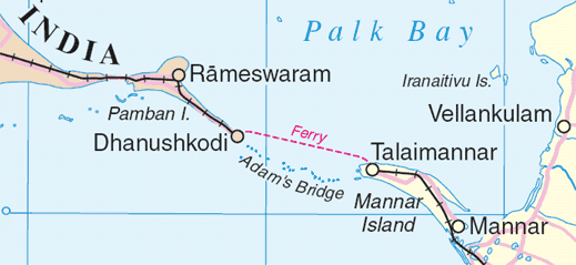
Adams_bridge_map.png
Wikimedia Commons
description page there
You can help
en:Adam's Bridge
India
Sri Lanka
www.un.org/Depts/Cartographic/map/profile/srilanka.pdf
United Nations
Geospatial Information Section
Geospatial, location data for a better world

depicts
media type<\/a>"}},"text\/plain":{"en":{"":"media type"}}},"{\"value\":\"image\\\/png\",\"type\":\"string\"}":{"text\/html":{"en":{"P1163":"image\/png"}},"text\/plain":{"en":{"P1163":"image\/png"}}}}">
media type
checksum<\/a>"}},"text\/plain":{"en":{"":"checksum"}}},"{\"value\":\"183a46a589e377dbfa5b43d6d5da640b0b0e32c0\",\"type\":\"string\"}":{"text\/html":{"en":{"P4092":"183a46a589e377dbfa5b43d6d5da640b0b0e32c0"}},"text\/plain":{"en":{"P4092":"183a46a589e377dbfa5b43d6d5da640b0b0e32c0"}}},"{\"value\":{\"entity-type\":\"property\",\"numeric-id\":459,\"id\":\"P459\"},\"type\":\"wikibase-entityid\"}":{"text\/html":{"en":{"":"determination method<\/a>"}},"text\/plain":{"en":{"":"determination method"}}},"{\"value\":{\"entity-type\":\"item\",\"numeric-id\":13414952,\"id\":\"Q13414952\"},\"type\":\"wikibase-entityid\"}":{"text\/html":{"en":{"P459":"SHA-1<\/a>"}},"text\/plain":{"en":{"P459":"SHA-1"}}}}">checksum
determination method
SHA-1
data size<\/a>"}},"text\/plain":{"en":{"":"data size"}}},"{\"value\":{\"amount\":\"+25416\",\"unit\":\"http:\\\/\\\/www.wikidata.org\\\/entity\\\/Q8799\"},\"type\":\"quantity\"}":{"text\/html":{"en":{"P3575":"25,416 byte<\/span>"}},"text\/plain":{"en":{"P3575":"25,416 byte"}}}}">data size
height<\/a>"}},"text\/plain":{"en":{"":"height"}}},"{\"value\":{\"amount\":\"+239\",\"unit\":\"http:\\\/\\\/www.wikidata.org\\\/entity\\\/Q355198\"},\"type\":\"quantity\"}":{"text\/html":{"en":{"P2048":"239 pixel<\/span>"}},"text\/plain":{"en":{"P2048":"239 pixel"}}}}">height
width<\/a>"}},"text\/plain":{"en":{"":"width"}}},"{\"value\":{\"amount\":\"+519\",\"unit\":\"http:\\\/\\\/www.wikidata.org\\\/entity\\\/Q355198\"},\"type\":\"quantity\"}":{"text\/html":{"en":{"P2049":"519 pixel<\/span>"}},"text\/plain":{"en":{"P2049":"519 pixel"}}}}">
Text is available under the Creative Commons Attribution-ShareAlike License. Additional terms may apply.
↑
checksum
determination method
SHA-1
data size<\/a>"}},"text\/plain":{"en":{"":"data size"}}},"{\"value\":{\"amount\":\"+25416\",\"unit\":\"http:\\\/\\\/www.wikidata.org\\\/entity\\\/Q8799\"},\"type\":\"quantity\"}":{"text\/html":{"en":{"P3575":"25,416 byte<\/span>"}},"text\/plain":{"en":{"P3575":"25,416 byte"}}}}">data size
height<\/a>"}},"text\/plain":{"en":{"":"height"}}},"{\"value\":{\"amount\":\"+239\",\"unit\":\"http:\\\/\\\/www.wikidata.org\\\/entity\\\/Q355198\"},\"type\":\"quantity\"}":{"text\/html":{"en":{"P2048":"239 pixel<\/span>"}},"text\/plain":{"en":{"P2048":"239 pixel"}}}}">height
width<\/a>"}},"text\/plain":{"en":{"":"width"}}},"{\"value\":{\"amount\":\"+519\",\"unit\":\"http:\\\/\\\/www.wikidata.org\\\/entity\\\/Q355198\"},\"type\":\"quantity\"}":{"text\/html":{"en":{"P2049":"519 pixel<\/span>"}},"text\/plain":{"en":{"P2049":"519 pixel"}}}}">
Text is available under the Creative Commons Attribution-ShareAlike License. Additional terms may apply.
↑
data size
height<\/a>"}},"text\/plain":{"en":{"":"height"}}},"{\"value\":{\"amount\":\"+239\",\"unit\":\"http:\\\/\\\/www.wikidata.org\\\/entity\\\/Q355198\"},\"type\":\"quantity\"}":{"text\/html":{"en":{"P2048":"239 pixel<\/span>"}},"text\/plain":{"en":{"P2048":"239 pixel"}}}}">height
width<\/a>"}},"text\/plain":{"en":{"":"width"}}},"{\"value\":{\"amount\":\"+519\",\"unit\":\"http:\\\/\\\/www.wikidata.org\\\/entity\\\/Q355198\"},\"type\":\"quantity\"}":{"text\/html":{"en":{"P2049":"519 pixel<\/span>"}},"text\/plain":{"en":{"P2049":"519 pixel"}}}}">
Text is available under the Creative Commons Attribution-ShareAlike License. Additional terms may apply.
↑
height
width<\/a>"}},"text\/plain":{"en":{"":"width"}}},"{\"value\":{\"amount\":\"+519\",\"unit\":\"http:\\\/\\\/www.wikidata.org\\\/entity\\\/Q355198\"},\"type\":\"quantity\"}":{"text\/html":{"en":{"P2049":"519 pixel<\/span>"}},"text\/plain":{"en":{"P2049":"519 pixel"}}}}">
Text is available under the Creative Commons Attribution-ShareAlike License. Additional terms may apply.
↑
Text is available under the Creative Commons Attribution-ShareAlike License. Additional terms may apply.
↑