17:
107:
had a station built here for the ski jumping championships, but it was closed immediately afterwards and is now just a request stop. After a tight left hand bend before the
136:
190:
48:
The
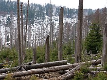
Eckerloch valley runs downhill from northwest to southeast and lies about 1½ kilometres due south of the highest mountain in the Harz, the
218:
79:
In the 1920s the locals built the first ski jump on the
Eckerloch, with the permission of the chamber of the prince of
96:
ski jumping championships took place here on a new jump, but it was soon abandoned due to its proximity to the
185:
83:. The site was chosen due to it good snow conditions after the ski jump on the southern slopes of the
151:
and then through the Goethe Moor to the station at
Goetheweg. It ran along the entire ridge to the
60:(1,033 metres) with a long southeast-running ridge with several crags and tors. To the east is the
132:
57:
127:
The
Eckerloch is on one of the most scenic hiking trails in the Harz. The Old Königsberg Way (
257:
80:
8:
97:
161:
153:
112:
116:
61:
194:
104:
37:
16:
251:
233:
220:
73:
93:
85:
160:
There is a rest area here along with a checkpoint here (No. 11) in the
89:
had been abandoned. It became one of the well-known jumps in the Harz.
29:
53:
209:
hiking map, No, 068, 1:25,000 series, 7th edition, Nationalpark Harz
33:
135:
mountain, began near
Eckerloch and ran uphill, alongside the old
49:
64:(1,039 metres) a southeast spur of the Brocken massif.
197:
at www.harzer-wandernadel.de. Accessed on 9 Sep 2012.
249:
131:), one of two trails that ran to the top of the
28:is a forested mountain valley, 845 metres above
72:The Eckerloch was the site of one of several
111:and another right-hander, the line reaches
147:, the old Eckerloch ski jump, towards the
52:. Its small unnamed stream runs into the
15:
76:quarries in the vicinity of Schierke.
250:
181:
179:
177:
115:(956 m), which is now only used as a
13:
174:
143:crags. From there it ran over the
14:
269:
100:and was demolished in the 1970s.
56:To the west is the mountain of
200:
1:
167:
20:View from the Eckerlochstieg
7:
43:
10:
274:
67:
122:
21:
19:
81:Stolberg-Wernigerode
40:of central Germany.
32:near the village of
234:51.7850°N 10.6178°E
230: /
98:Inner German Border
193:2016-02-07 at the
162:Harzer Wandernadel
129:alte Königsbergweg
92:In 1950 the first
22:
154:Hirschhornklippen
137:Königsberg Quarry
113:Goetheweg station
265:
245:
244:
242:
241:
240:
239:51.7850; 10.6178
235:
231:
228:
227:
226:
223:
210:
204:
198:
183:
117:locomotive depot
109:Eckerloch Bridge
273:
272:
268:
267:
266:
264:
263:
262:
248:
247:
238:
236:
232:
229:
224:
221:
219:
217:
216:
214:
213:
205:
201:
195:Wayback Machine
184:
175:
170:
164:hiking system.
125:
105:Brocken Railway
70:
46:
12:
11:
5:
271:
261:
260:
212:
211:
199:
187:(11) Eckerloch
172:
171:
169:
166:
124:
121:
69:
66:
45:
42:
38:Harz Mountains
9:
6:
4:
3:
2:
270:
259:
256:
255:
253:
246:
243:
208:
203:
196:
192:
189:
188:
182:
180:
178:
173:
165:
163:
158:
156:
155:
150:
146:
142:
141:Kanzelklippen
138:
134:
130:
120:
118:
114:
110:
106:
101:
99:
95:
90:
88:
87:
82:
77:
75:
65:
63:
62:Heinrichshöhe
59:
55:
51:
41:
39:
35:
31:
27:
18:
215:
206:
202:
186:
159:
152:
149:Kesselklippe
148:
144:
140:
139:, up to the
128:
126:
108:
102:
91:
84:
78:
74:Harz granite
71:
47:
25:
23:
258:Wernigerode
237: /
145:Rabenklippe
94:East German
86:Erdbeerkopf
225:10°37′04″E
222:51°47′06″N
168:References
133:Königsberg
58:Königsberg
54:Cold Bode
30:sea level
26:Eckerloch
252:Category
207:Hochharz
191:Archived
44:Location
34:Schierke
68:History
50:Brocken
36:in the
123:Hiking
103:The
24:The
254::
176:^
157:.
119:.
Text is available under the Creative Commons Attribution-ShareAlike License. Additional terms may apply.
