47:
426:
31:
526:
54:
220:
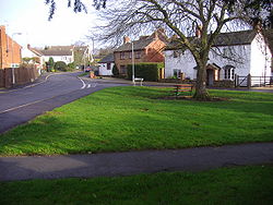
414:. They are all listed as Grade II in the Daventry list under Orchard Street, the Orchards and School Street. They include the Manor House and the school built in 1859 which once catered for the education of 45 children, but it is now a private residence.
469:
378:"Drægtūn", meaning "farmstead at or near a portage or slope used for dragging down loads" or "Farmstead where drays or sledges are used". This is a common place-name throughout
407:
It was enclosed in 1753. In recent years the hamlet has expanded and is surrounded by and is part of the modern town of
Daventry (both civil and ecclesiastical parishes).
404:
but it is thought to be as old, or nearly as old, as
Daventry. It is thought to have peasant origins, although a Roman pavement was discovered near to the hamlet in 1736.
97:
260:
304:
244:
46:
530:
237:
550:
206:
458:
545:
366:
mile (1.2 km) from the centre, occupying mainly with suburban housing the lower-lying north western side of the town.
425:
232:
489:
296:
286:
249:
194:
160:
485:
124:
90:
510:
499:
391:
82:
291:
480:'A Dictionary of British Place-Names', 'Oxford Paperback Reference', A. D. Mills, OUP Oxford, 2003,
174:
268:
225:
114:
30:
106:
8:
142:
481:
454:
470:
Ordnance Survey of Great
Britain New Popular Edition, Sheet 132 - Coventry and Rugby
349:
199:
132:
67:
411:
401:
341:
539:
319:
306:
150:
375:
184:
395:
353:
379:
345:
166:
525:
432:
412:
List of
Buildings of Special Architectural or Historic Interest
410:
There are seven buildings or groups of buildings on the
537:
453:’OS’ Explorer Map, Rugby & Daventry 222,
400:Not much is known about the origins of the
538:
13:
14:
562:
519:
524:
424:
52:
45:
29:
53:
551:West Northamptonshire District
504:
493:
474:
463:
447:
1:
440:
7:
546:Hamlets in Northamptonshire
392:History of Northamptonshire
369:
91:OS grid reference
18:Human settlement in England
10:
567:
417:
389:
385:
374:The name derives from the
531:Drayton, Northamptonshire
277:
259:
255:
243:
231:
219:
215:
205:
193:
183:
173:
159:
141:
123:
105:
89:
77:
40:
28:
23:
511:British Listed Buildings
195:Postcode district
125:Ceremonial county
107:Unitary authority
533:at Wikimedia Commons
115:West Northamptonshire
175:Sovereign state
352:, in the parish of
348:, in the county of
316: /
85:) Includes Daventry
261:UK Parliament
207:Dialling code
529:Media related to
459:978-0-319-23734-2
335:
334:
558:
528:
513:
508:
502:
497:
491:
488:, 9780191578472
478:
472:
467:
461:
451:
428:
365:
364:
360:
350:Northamptonshire
331:
330:
328:
327:
326:
321:
317:
314:
313:
312:
309:
297:Northamptonshire
283:
238:Northamptonshire
226:Northamptonshire
169:
133:Northamptonshire
101:
100:
68:Northamptonshire
66:Location within
56:
55:
49:
33:
21:
20:
566:
565:
561:
560:
559:
557:
556:
555:
536:
535:
522:
517:
516:
509:
505:
500:History On Line
498:
494:
479:
475:
468:
464:
452:
448:
443:
436:
429:
420:
398:
388:
372:
362:
358:
357:
324:
322:
318:
315:
310:
307:
305:
303:
302:
301:
281:
273:
165:
155:
137:
119:
96:
95:
73:
72:
71:
70:
64:
63:
62:
61:
57:
36:
19:
12:
11:
5:
564:
554:
553:
548:
521:
520:External links
518:
515:
514:
503:
492:
473:
462:
445:
444:
442:
439:
438:
437:
430:
423:
419:
416:
387:
384:
371:
368:
333:
332:
320:52.26°N 1.18°W
300:
299:
294:
289:
284:
282:List of places
278:
275:
274:
272:
271:
265:
263:
257:
256:
253:
252:
247:
241:
240:
235:
229:
228:
223:
217:
216:
213:
212:
209:
203:
202:
197:
191:
190:
187:
181:
180:
179:United Kingdom
177:
171:
170:
163:
157:
156:
154:
153:
147:
145:
139:
138:
136:
135:
129:
127:
121:
120:
118:
117:
111:
109:
103:
102:
93:
87:
86:
79:
75:
74:
65:
59:
58:
51:
50:
44:
43:
42:
41:
38:
37:
34:
26:
25:
17:
9:
6:
4:
3:
2:
563:
552:
549:
547:
544:
543:
541:
534:
532:
527:
512:
507:
501:
496:
490:
487:
483:
477:
471:
466:
460:
456:
450:
446:
434:
427:
422:
421:
415:
413:
408:
405:
403:
397:
393:
383:
381:
377:
367:
355:
351:
347:
343:
339:
329:
298:
295:
293:
290:
288:
285:
280:
279:
276:
270:
267:
266:
264:
262:
258:
254:
251:
250:East Midlands
248:
246:
242:
239:
236:
234:
230:
227:
224:
222:
218:
214:
210:
208:
204:
201:
198:
196:
192:
188:
186:
182:
178:
176:
172:
168:
164:
162:
158:
152:
151:East Midlands
149:
148:
146:
144:
140:
134:
131:
130:
128:
126:
122:
116:
113:
112:
110:
108:
104:
99:
94:
92:
88:
84:
80:
76:
69:
48:
39:
35:Drayton Green
32:
27:
22:
16:
523:
506:
495:
476:
465:
449:
409:
406:
399:
373:
337:
336:
325:52.26; -1.18
81:6,415 (
15:
376:Old English
323: /
83:2001 Census
540:Categories
486:0191578479
441:References
390:See also:
78:Population
245:Ambulance
185:Post town
431:The Old
396:Daventry
370:Toponymy
354:Daventry
269:Daventry
189:DAVENTRY
418:Gallery
386:History
380:England
361:⁄
346:England
338:Drayton
308:52°16′N
292:England
167:England
161:Country
60:Drayton
24:Drayton
484:
457:
433:School
402:hamlet
342:hamlet
311:1°11′W
221:Police
143:Region
98:SP5763
435:House
340:is a
211:01327
482:ISBN
455:ISBN
394:and
233:Fire
200:NN11
344:in
542::
382:.
356:,
287:UK
363:4
359:3
Text is available under the Creative Commons Attribution-ShareAlike License. Additional terms may apply.

