43:
214:
The current population of
Chegutu District is not publicly known. In 1992, the national census put the district population at 191,909 people. By 2002's national census, that population count had increased to 224,589. The next national population census in
257:
315:
383:
359:
155:
406:
56:
42:
282:
316:"Artisanal Gold Mining in Zimbabwe: Prospects and Challenges for the Low Income Groups in the Chegutu Mining District"
270:
The local economic development processes in low-income countries: The case of the metropolis of
Chegutu in Zimbabwe.
349:
269:
401:
119:
103:
354:
238:
233:
228:
98:
8:
334:
159:
330:
203:
194:, both owned by owned by Africa Consolidated Resources (ACR). Other mines include
143:
286:
151:
147:
186:
deposits are found in the district and the two largest gold mines there are the
395:
372:
71:
58:
126:. The district headquarters is located in Chegutu, a city which lies of the
206:
is also prevalent, often using unsafe methods, such as mercury separation.
171:
300:
166:, is located about 120 kilometres (75 mi), by road, southwest of
268:
Simba, A., Nyandoro, Z. F., Munyoro, G., & Chimhande, D. (2015).
216:
195:
131:
123:
91:
163:
17:
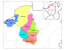
146:, in central northern Zimbabwe. Chegutu District is bordered by
167:
127:
384:
Next
Population Census In Zimbabwe Scheduled For August 2012
301:"Hartley Mine, Chegutu District, Mashonaland West, Zimbabwe"
183:
314:
Chawatama, Chrispen Tauya; Oyelana, Akeem
Adewale (2019).
47:
Chegutu
District (light pink) in Mashonaland West Province
219:
is scheduled from 18 August 2012 through 28 August 2012.
373:
Population Count of
Chegutu District In 1992 & 2002
182:
Chegutu
District is primarily a mining district. Large
16:
This article is about the district. For the town, see
350:"Illegal Use of Mercury in Mining Sector Continues"
258:
Map
Showing Harare And Chegutu With Distance Marker
174:of Zimbabwe and the largest city in that country.
393:
313:
190:(originally a pre-colonial mining site) and the
407:Districts of Mashonaland West Province
394:
362:from the original on 19 November 2021.
347:
348:Mupesa, Conrad (19 November 2021).
154:to the north and to the east, lies
25:Place in Mashonaland West, Zimbabwe
13:
335:10.31901/24566608.2019/68.1-3.3167
14:
418:
41:
377:
366:
341:
307:
293:
275:
272:Local Economy, 30(4), 405-420.
262:
251:
1:
244:
209:
160:Mashonaland Central Province
7:
222:
142:The district is located in
137:
10:
423:
285:. ZimPlats. Archived from
177:
15:
144:Mashonaland West Province
120:Mashonaland West Province
97:
87:
52:
40:
30:
323:Journal of Human Ecology
283:"Hartley Platinum Mine"
150:to the south and west,
114:, originally known as
239:Geography of Zimbabwe
234:Provinces of Zimbabwe
229:Districts of Zimbabwe
204:Artisanal gold mining
134:Road, (Highway A-5).
289:on 10 December 2010.
118:, is a district of
68: /
198:mines such as the
202:opened in 1987.
162:. Its main town,
109:
108:
72:18.000°S 30.000°E
414:
402:Chegutu District
386:
381:
375:
370:
364:
363:
345:
339:
338:
320:
311:
305:
304:
297:
291:
290:
279:
273:
266:
260:
255:
104:Mashonaland West
83:
82:
80:
79:
78:
73:
69:
66:
65:
64:
61:
45:
35:Hartley District
32:Chegutu District
28:
27:
422:
421:
417:
416:
415:
413:
412:
411:
392:
391:
390:
389:
382:
378:
371:
367:
346:
342:
318:
312:
308:
299:
298:
294:
281:
280:
276:
267:
263:
256:
252:
247:
225:
212:
180:
152:Zvimba District
148:Kadoma District
140:
77:-18.000; 30.000
76:
74:
70:
67:
62:
59:
57:
55:
54:
48:
36:
33:
26:
21:
12:
11:
5:
420:
410:
409:
404:
388:
387:
376:
365:
340:
329:(1/3): 26–41.
306:
292:
274:
261:
249:
248:
246:
243:
242:
241:
236:
231:
224:
221:
211:
208:
188:Butterfly Mine
179:
176:
156:Mazoe District
139:
136:
107:
106:
101:
95:
94:
89:
85:
84:
50:
49:
46:
38:
37:
34:
31:
24:
9:
6:
4:
3:
2:
419:
408:
405:
403:
400:
399:
397:
385:
380:
374:
369:
361:
357:
356:
351:
344:
336:
332:
328:
324:
317:
310:
302:
296:
288:
284:
278:
271:
265:
259:
254:
250:
240:
237:
235:
232:
230:
227:
226:
220:
218:
207:
205:
201:
197:
193:
189:
185:
175:
173:
169:
165:
161:
157:
153:
149:
145:
135:
133:
129:
125:
121:
117:
113:
105:
102:
100:
96:
93:
90:
86:
81:
53:Coordinates:
51:
44:
39:
29:
23:
19:
379:
368:
353:
343:
326:
322:
309:
295:
287:the original
277:
264:
253:
213:
200:Hartley Mine
199:
191:
187:
181:
141:
115:
111:
110:
22:
75: /
396:Categories
355:The Herald
245:References
210:Population
192:Giant Mine
303:. Mindat.
360:Archived
223:See also
217:Zimbabwe
196:platinum
138:Location
132:Bulawayo
124:Zimbabwe
99:Province
92:Zimbabwe
178:Economy
172:capital
164:Chegutu
116:Hartley
112:Chegutu
88:Country
63:30°00′E
60:18°00′S
18:Chegutu
170:, the
168:Harare
128:Harare
319:(PDF)
184:gold
331:doi
158:in
398::
358:.
352:.
327:68
325:.
321:.
122:,
337:.
333::
130:-
20:.
Text is available under the Creative Commons Attribution-ShareAlike License. Additional terms may apply.
