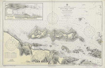
77:
45:
29:
52:
473:
277:
During World War I, Broughton Strait was closed to shipping traffic via mines strung between
Malcolm Island and Vancouver Island at McNeill point. Two small torpedo boats patrolled the waters at night.
514:
548:
507:
110:
500:
538:
312:
44:
533:
443:
248:
173:
244:
201:
451:
168:
76:
543:
263:, and Captain Vancouver named Broughton Strait, Broughton Island, and Broughton Archipelago all after
317:
264:
307:
440:
Standing Up with Ga'axsta'las: Jane
Constance Cook and the Politics of Memory, Church, and Custom
480:
287:
205:
157:
397:
370:
343:
142:
260:
488:
8:
268:
28:
447:
392:
365:
338:
217:
213:
193:
189:
92:
484:
240:
221:
208:, which also lies beyond the western end of Broughton Strait, and the mouth of
197:
527:
267:, who accompanied Vancouver on his exploration in these waters as captain of
125:
112:
228:
209:
236:
232:
185:
147:
96:
472:
438:
Robertson, Leslie A. & the Kwagu'l Gixsam Clan (2012).
212:. Farther east from Broughton Strait is the beginning of
417:
415:
549:Central Coast of British Columbia geography stubs
525:
103:
412:
508:
204:, on the farther side of which is the larger
227:Communities on the Broughton Strait include
515:
501:
437:
421:
33:View of Broughton Strait from Port McNeil
251:is located in the middle of the strait.
51:
526:
196:, Canada, separating that island from
479:This article about a location on the
331:
259:The area was explored in 1792 by the
467:
444:University of British Columbia Press
300:
13:
16:Strait in British Columbia, Canada
14:
560:
539:Central Coast of British Columbia
481:Central Coast of British Columbia
471:
75:
50:
43:
27:
385:
358:
1:
431:
487:. You can help Knowledge by
313:Geographical Names Data Base
7:
534:Straits of British Columbia
281:
231:, on Vancouver Island, and
10:
565:
466:
254:
167:
163:
153:
141:
102:
88:
69:
38:
26:
21:
318:Natural Resources Canada
293:
265:William Robert Broughton
188:off the north coast of
288:British Columbia Coast
206:Queen Charlotte Strait
158:Queen Charlotte Strait
398:BC Geographical Names
371:BC Geographical Names
344:BC Geographical Names
261:Vancouver Expedition
126:50.6036°N 127.0356°W
459:- Total pages: 596
366:"Haddington Island"
122: /
393:"Broughton Island"
339:"Broughton Strait"
308:"Broughton Strait"
216:, which leads via
131:50.6036; -127.0356
496:
495:
460:
442:(2012 ed.).
249:Haddington Island
245:Cormorant Islands
222:Strait of Georgia
218:Discovery Passage
202:Cormorant Islands
179:
178:
174:Haddington Island
556:
517:
510:
503:
475:
468:
458:
457:
425:
419:
410:
409:
407:
405:
389:
383:
382:
380:
378:
362:
356:
355:
353:
351:
335:
329:
328:
326:
324:
304:
214:Johnstone Strait
194:British Columbia
190:Vancouver Island
182:Broughton Strait
137:
136:
134:
133:
132:
127:
123:
120:
119:
118:
115:
105:
93:British Columbia
79:
58:Broughton Strait
54:
53:
47:
31:
22:Broughton Strait
19:
18:
564:
563:
559:
558:
557:
555:
554:
553:
524:
523:
522:
521:
464:
454:
434:
429:
428:
420:
413:
403:
401:
391:
390:
386:
376:
374:
364:
363:
359:
349:
347:
337:
336:
332:
322:
320:
306:
305:
301:
296:
284:
257:
130:
128:
124:
121:
116:
113:
111:
109:
108:
84:
83:
82:
81:
80:
65:
64:
63:
62:
61:
60:
59:
55:
34:
17:
12:
11:
5:
562:
552:
551:
546:
541:
536:
520:
519:
512:
505:
497:
494:
493:
483:, Canada is a
476:
462:
461:
452:
433:
430:
427:
426:
422:Robertson 2012
411:
384:
357:
330:
298:
297:
295:
292:
291:
290:
283:
280:
256:
253:
247:respectively.
177:
176:
171:
165:
164:
161:
160:
155:
151:
150:
145:
139:
138:
106:
100:
99:
90:
86:
85:
74:
73:
72:
71:
70:
67:
66:
57:
56:
49:
48:
42:
41:
40:
39:
36:
35:
32:
24:
23:
15:
9:
6:
4:
3:
2:
561:
550:
547:
545:
544:Kwakwaka'wakw
542:
540:
537:
535:
532:
531:
529:
518:
513:
511:
506:
504:
499:
498:
492:
490:
486:
482:
477:
474:
470:
469:
465:
455:
453:9780774823869
449:
445:
441:
436:
435:
424:, p. 514
423:
418:
416:
400:
399:
394:
388:
373:
372:
367:
361:
346:
345:
340:
334:
319:
315:
314:
309:
303:
299:
289:
286:
285:
279:
275:
273:
272:
266:
262:
252:
250:
246:
242:
238:
234:
230:
225:
223:
219:
215:
211:
207:
203:
199:
195:
191:
187:
183:
175:
172:
170:
166:
162:
159:
156:
152:
149:
146:
144:
140:
135:
107:
101:
98:
94:
91:
87:
78:
68:
46:
37:
30:
25:
20:
489:expanding it
478:
463:
439:
402:. Retrieved
396:
387:
375:. Retrieved
369:
360:
348:. Retrieved
342:
333:
321:. Retrieved
311:
302:
276:
270:
258:
229:Port McNeill
226:
210:Knight Inlet
181:
180:
154:Part of
129: /
117:127°02′08″W
104:Coordinates
528:Categories
432:References
404:31 January
377:31 January
350:31 January
323:31 January
114:50°36′13″N
237:Alert Bay
282:See also
233:Sointula
89:Location
271:Chatham
255:History
241:Malcolm
220:to the
198:Malcolm
169:Islands
450:
186:strait
148:strait
97:Canada
294:Notes
239:, on
184:is a
485:stub
448:ISBN
406:2024
379:2024
352:2024
325:2024
269:HMS
243:and
235:and
200:and
143:Type
530::
446:.
414:^
395:.
368:.
341:.
316:.
310:.
274:.
224:.
192:,
95:,
516:e
509:t
502:v
491:.
456:.
408:.
381:.
354:.
327:.
Text is available under the Creative Commons Attribution-ShareAlike License. Additional terms may apply.


