211:
239:
161:
20:
31:
225:
321:
85:
rivers. In the latter part of the 19th century, the Belle
Fourche River was known as the North Fork of the Cheyenne River. Belle Fourche is a name derived from French meaning "beautiful fork".
382:
140:
The point at which the river flows out of
Wyoming and into South Dakota is the lowest elevation point in the state of Wyoming at 3,099 feet (945 m). This is the
325:(Map). 1:3,000,000. Atlas of the United States. Cartography by H.F. Walling, O.W. Gray, and H.H. Lloyd & Co. Cincinnati: Stedman, Brown & Lyon. 1872.
421:
480:
475:
357:
485:
399:
495:
490:
460:
285:
199:
in western South Dakota. The total irrigation area of the river in South Dakota is approximately 57,000 acres (230 km).
141:
465:
405:
252:
110:
24:
308:
340:
172:
336:
118:
361:
470:
126:
257:
145:
134:
94:
148:, the river has an average discharge of 397 cubic feet per second (11.2 cubic metres per second)
130:
102:
8:
244:
106:
291:
281:
75:
133:, it turns ENE and joins the Cheyenne approximately 50 miles (80 km) ENE of
98:
47:
383:"USGS Surface Water data for South Dakota: USGS Surface-Water Annual Statistics"
309:
U.S. Geological Survey
Geographic Names Information System: Belle Fourche River
230:
82:
78:
59:
454:
436:
423:
216:
71:
280:(2nd ed.). Bloomington, IN: Lakota Language Consortium. p. 861.
19:
196:
122:
160:
192:
63:
117:, it turns abruptly southeast and flows in western South Dakota, past
30:
55:
322:
Nebraska, and the territories of Dakota, Idaho, Montana and
Wyoming
295:
114:
67:
345:. American guide series. University of South Dakota. p. 4.
335:
23:
A view of the upper course of the Belle
Fourche River in
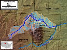
62:, approximately 290 miles (470 km) long, in the
206:
97:, approximately 18 miles (29 km) southwest of
355:
101:. It flows northeast around the north side of the
452:
16:River in Wyoming and South Dakota, United States
34:Course and watershed of the Belle Fourche River
191:The river provides significant recreation and
93:It rises in northeastern Wyoming, in southern
142:second-highest low point of any U.S. state
29:
18:
275:
453:
313:
481:Rivers of Butte County, South Dakota
476:Rivers of Meade County, South Dakota
155:
13:
486:Rivers of Campbell County, Wyoming
14:
507:
496:Tributaries of the Missouri River
392:
121:and around the north side of the
237:
223:
209:
159:
491:Rivers of Crook County, Wyoming
406:United States Geological Survey
461:Devils Tower National Monument
375:
349:
329:
302:
269:
253:List of rivers of South Dakota
25:Devils Tower National Monument
1:
342:South Dakota place-names, v.3
263:
7:
202:
113:. Near the state line with
10:
512:
358:"Elevations and Distances"
276:Ullrich, Jan, ed. (2011).
258:List of rivers of Wyoming
88:
356:U.S. Geological Survey.
337:Federal Writers' Project
151:
401:The National Map Viewer
51:
466:Rivers of South Dakota
35:
27:
278:New Lakota Dictionary
81:via the Cheyenne and
33:
22:
437:44.4334°N 102.3030°W
103:Bear Lodge Mountains
74:. It is part of the
433: /
245:South Dakota portal
40:Belle Fourche River
442:44.4334; -102.3030
364:on 16 January 2008
171:. You can help by
36:
28:
471:Rivers of Wyoming
287:978-0-9761082-9-0
189:
188:
76:Mississippi River
503:
448:
447:
445:
444:
443:
438:
434:
431:
430:
429:
426:
415:
413:
412:
387:
386:
379:
373:
372:
370:
369:
360:. Archived from
353:
347:
346:
333:
327:
326:
317:
311:
306:
300:
299:
273:
247:
242:
241:
240:
233:
228:
227:
226:
219:
214:
213:
212:
184:
181:
163:
156:
511:
510:
506:
505:
504:
502:
501:
500:
451:
450:
441:
439:
435:
432:
427:
424:
422:
420:
419:
410:
408:
398:
395:
390:
381:
380:
376:
367:
365:
354:
350:
334:
330:
319:
318:
314:
307:
303:
288:
274:
270:
266:
243:
238:
236:
229:
224:
222:
215:
210:
208:
205:
185:
179:
176:
169:needs expansion
154:
95:Campbell County
91:
17:
12:
11:
5:
509:
499:
498:
493:
488:
483:
478:
473:
468:
463:
417:
416:
394:
393:External links
391:
389:
388:
374:
348:
328:
312:
301:
286:
267:
265:
262:
261:
260:
255:
249:
248:
234:
231:Wyoming portal
220:
204:
201:
187:
186:
166:
164:
153:
150:
125:. In southern
90:
87:
60:Cheyenne River
52:Šahíyela Wakpá
15:
9:
6:
4:
3:
2:
508:
497:
494:
492:
489:
487:
484:
482:
479:
477:
474:
472:
469:
467:
464:
462:
459:
458:
456:
449:
446:
407:
403:
402:
397:
396:
384:
378:
363:
359:
352:
344:
343:
338:
332:
324:
323:
316:
310:
305:
297:
293:
289:
283:
279:
272:
268:
259:
256:
254:
251:
250:
246:
235:
232:
221:
218:
217:Rivers portal
207:
200:
198:
194:
183:
174:
170:
167:This section
165:
162:
158:
157:
149:
147:
143:
138:
136:
132:
128:
124:
120:
119:Belle Fourche
116:
112:
108:
104:
100:
96:
86:
84:
80:
77:
73:
69:
65:
61:
57:
53:
49:
45:
41:
32:
26:
21:
418:
409:. Retrieved
400:
377:
366:. Retrieved
362:the original
351:
341:
331:
320:
315:
304:
277:
271:
190:
177:
173:adding to it
168:
139:
127:Meade County
111:Devils Tower
92:
72:South Dakota
43:
42:(pronounced
39:
37:
440: /
428:102°18′11″W
197:agriculture
146:Elm Springs
123:Black Hills
64:U.S. states
455:Categories
425:44°26′00″N
411:2012-09-20
368:2008-01-22
296:2008922508
264:References
193:irrigation
180:April 2024
135:Rapid City
107:Moorcroft
79:watershed
56:tributary
44:bel FOOSH
339:(1940).
203:See also
131:Hereford
83:Missouri
404:(Map).
115:Montana
105:, past
68:Wyoming
58:of the
54:) is a
294:
284:
99:Wright
89:Course
48:Lakota
152:Usage
144:. At
129:near
292:LCCN
282:ISBN
195:for
109:and
70:and
38:The
175:.
66:of
457::
290:.
137:.
50::
46:;
414:.
385:.
371:.
298:.
182:)
178:(
Text is available under the Creative Commons Attribution-ShareAlike License. Additional terms may apply.

