100:
137:
4030:
122:
84:
152:
485:
1454:, there were 16,589 people, 6,548 households, and 4,643 families residing in the county. The population density was 48.6 inhabitants per square mile (18.8/km). There were 7,849 housing units at an average density of 23.0 per square mile (8.9/km). The racial makeup of the county was 96.8% white, 0.7% black or African American, 0.6% American Indian, 0.2% Asian, 0.2% from other races, and 1.5% from two or more races. Those of Hispanic or Latino origin made up 0.6% of the population. In terms of ancestry, 23.4% were
206:
70:
50:
5277:
227:
3900:
3917:
3892:
375:
3875:
2476:
965:
955:
1015:
1005:
995:
985:
975:
2834:. Barbour County's original magisterial districts were Barker, Cove, Elk, Glade, Philippi, Pleasant, and Union. Between 1880 and 1890, part of Barker District was split off to form Valley District. These eight districts continued until the 1970s, when they were consolidated into three districts: North, South, and West.
702:. The Union troops had marched all night through a heavy rain storm to arrive just before daylight. The surprise attack awakened the sleeping Confederates. After firing a few shots at the advancing Union troops, the Southerners broke lines and began running frantically to the south, some still in their bed clothes.
667:) called to repeal the Ordinance. The delegates from Barbour County for the first convention were Spencer Dayton, John H. Shuttleworth, and E.H. Manafee. Barbour County had voted in favor of Virginia's secession, though, and a palmetto secession flag had been flying above the courthouse since January, 1861.
1546:
There were 6,123 households, out of which 30.10% had children under the age of 18 living with them, 57.20% were married couples living together, 10.30% had a female householder with no husband present, and 28.70% were non-families. 25.10% of all households were made up of individuals, and 12.60% had
736:
In 1990, private developers offered
Barbour County citizens $ 4M to $ 6M annually in host fees to accept out-of-state garbage into a County landfill over the following three decades. Up to 200,000 tons of garbage per month would be delivered. (At the time, the county's annual budget was only about $
1554:
The median income for a household in the county was $ 24,729, and the median income for a family was $ 29,722. Males had a median income of $ 24,861 versus $ 17,433 for females. The per capita income for the county was $ 12,440. 22.60% of the population and 18.40% of families were below the poverty
1473:
Of the 6,548 households, 30.7% had children under the age of 18 living with them, 54.8% were married couples living together, 10.9% had a female householder with no husband present, 29.1% were non-families, and 24.2% of all households were made up of individuals. The average household size was 2.46
1550:
In the county, the population was spread out, with 23.00% under the age of 18, 9.40% from 18 to 24, 26.80% from 25 to 44, 25.20% from 45 to 64, and 15.60% who were 65 years of age or older. The median age was 39 years. For every 100 females there were 96.70 males. For every 100 females age 18 and
1494:
of 2000, there were 15,557 people, 6,123 households, and 4,365 families residing in the county. The population density was 46 people per square mile (18 people/km). There were 7,348 housing units at an average density of 22 per square mile (8.5/km). The racial makeup of the county was 97.36%
1441:
Of the 5,813 households, 47.5% were married couples living together, 25.5% had a female householder with no spouse present, 18.4% had a male householder with no spouse present. The average household and family size was 3.22. The median age in the county was 42.7 years with 20.5% of the population
592:
settlements and so conflicts with Native
Americans were relatively infrequent in the early days. Nevertheless, the Talbotts were obliged to leave their homestead several times for safety and twice found it necessary to retreat back east of the Alleghenies, returning each time. No member of this
1477:
The median income for a household in the county was $ 31,212 and the median income for a family was $ 39,434. Males had a median income of $ 34,573 versus $ 21,797 for females. The per capita income for the county was $ 17,304. About 14.3% of families and 18.4% of the population were below the
2451:
Major employment in
Barbour County is provided by health care and social service sectors, retail, education, accommodation and food services, logging and wood product manufacturing, trucking and construction. The largest employers are Alderson Broaddus University and Broaddus Hospital.
583:
The first white settlement in present-day
Barbour County was established in 1780 by Richard Talbott – along with his brother Cotteral and sister Charity – about three miles (4.8 km) downriver from the future site of Philippi. At this time the region was still a part of
2466:
production (wood and wood products) is also present. (The county is a member of the West
Virginia Hardwood Alliance Zone.) There is notable production of eggs and horse raising, but the major agricultural products are livestock, forage, dairy foods and orchard fruits.
3687:: Containing large scale copper plate Maps of Each State and Territory of the United States, and the Provinces of Canada ... Special History of the Virginias, Maps and Histories of Lewis, Upshur and Barbour Counties, West Virginia ...
596:
Over time, parts of the future
Barbour County were included in the newly created Harrison (1784), Randolph (1787), and Lewis (1816) Counties. Barbour County itself was created in 1843 and named for the late Virginia politician and
2837:
The names and boundaries of
Barbour county's historic magisterial districts were preserved as assessment and tax districts, alongside the corporations of Belington, Junior, and Philippi. The City of Philippi is divided into four
1579:
Barbour County was generally split for most of the twentieth century, though it tended to vote more for
Democrats rather than Republicans. This is due to the county's split position in the American Civil War between
4074:
4069:
4084:
4049:
4079:
4064:
4054:
2931:
4059:
712:
into the national spotlight, and he would soon be given command of all Union armies. The battle also inspired more vocal protests in the
Western part of Virginia against secession. On 11 June, the second
717:
met in that city and
Barbour County was again represented by Dayton and Shuttleworth, who were this time joined by N.H. Taft. The Convention nullified the Virginia Ordinance of Secession and named
3647:
3021:
4818:
3720:
3167:
2794:
2644:
629:
551:, also known as the "Philippi Races", was fought in Barbour County on June 3, 1861. Although a minor action, it is generally considered the first land engagement of the
165:
4610:
3725:
2417:
2388:
2359:
2330:
2301:
2272:
2243:
2214:
2185:
2156:
2127:
2098:
2069:
2040:
2011:
1982:
1953:
1924:
1895:
1866:
1837:
1808:
1779:
1750:
1721:
1692:
1663:
1634:
884:, the county has a total area of 343 square miles (890 km), of which 341 square miles (880 km) is land and 1.8 square miles (4.7 km) (0.5%) is water.
3968:
2842:, all of which are in Philippi District. The first and second wards of Belington are in Valley District, while the second and third ward are in Barker District.
806:
4891:
1410:, there were 15,465 people and 5,813 households residing in the county. There were 7,114 housing units in Barbour. The racial makeup of the county was 93.5%
3476:
1531:
of any race. In addition, the area has a significant population of racially mixed (though often light-skinned and blue-eyed) people, known locally as 'the
753:
678:. The battle was later lampooned as the "Philippi Races" because of the hurried retreat by the Confederate troops encamped in the town. (The skirmish is
2830:, with the intention of encouraging local government. This proved impractical in the heavily rural state, and in 1872 the townships were converted into
4690:
136:
99:
4590:
3536:
3506:
3446:
274:
1427:
1584:
and Secessionists. Since the 2000 presidential election, Barbour County has followed the trend with the rest of the state towards the Republicans.
729:
The economy and infrastructure in Barbour grew steadily, but slowly, through the late 19th century. Although the first railroad had reached nearby
4585:
3837:
5311:
4637:
1569:
443:
3805:
1555:
line. Out of the total population, 32.00% of those under the age of 18 and 16.70% of those 65 and older were living below the poverty line.
4722:
3264:
935:– the county's only WMA – is located on that stream and lake in the eastern portion. All of the mentioned streams are part of the greater
4871:
4788:
4765:
4557:
4283:
3961:
2894:
2664:
4901:
4848:
4423:
3145:
2784:
151:
4403:
2759:
932:
733:
in 1852, a narrow-gauge railroad was not laid through the county until the early 1880s; a standard gauge line followed in the 1890s.
3795:
682:
every June during the town's "Blue and Gray Reunion".) At daylight on June 3, two columns of Union forces under the command of Col.
5306:
4881:
4808:
463:
4717:
4524:
4273:
3946:
3785:: Kent Reger, Job Printer. (A detailed account of life and work on a Barbour County farm in the late-19th/early-20th centuries.)
3093:
2941:
2659:
1547:
someone living alone who was 65 years of age or older. The average household size was 2.47 and the average family size was 2.94.
453:
5301:
3954:
3119:
4318:
4313:
4220:
2619:
1423:
589:
4041:
4707:
4418:
4160:
3693:; Subsequent reprint by Wes Cochran. Contains a brief history of Barbour County and biographical sketches of its citizens.)
2779:
2563:
639:, published starting in August 1857 and running only to about June 1861. It was put out by Thompson Surghnor (1820-1864).
4823:
4712:
4632:
4803:
4605:
3830:
3484:
3304:
2864:
844:
671:
548:
533:
121:
4984:
4627:
4580:
4438:
2946:
2804:
385:
349:
5177:
5142:
5052:
3071:
1601:
1596:
585:
3507:"DP02 SELECTED SOCIAL CHARACTERISTICS IN THE UNITED STATES – 2006-2010 American Community Survey 5-Year Estimates"
5316:
5172:
5167:
5082:
5057:
5032:
4921:
4858:
4665:
4570:
4200:
3416:
2999:
2951:
2888:
2604:
968:
896:
3544:
3514:
3454:
3282:
5197:
5157:
5122:
5112:
5072:
4997:
4660:
4575:
4469:
4398:
3933:
3884:
3741:
3705:
3574:
3391:
3043:
2774:
2754:
1056:
1044:
679:
309:
303:
297:
3221:
The history of Barbour County, West Virginia, from its earliest exploration and settlement to the present time
5262:
5242:
5212:
5202:
5192:
5182:
5132:
5097:
5087:
5077:
5062:
5037:
5022:
5007:
4833:
4740:
4675:
4428:
3864:
3823:
2926:
2789:
2458:
mining has been significant in Barbour; seven times as much tonnage has been produced from underground as by
1435:
1062:
706:
563:
911:– are sited. Tributaries of the Tygart in the County include Teter Creek, Laurel Creek, Hacker's Creek, the
5247:
5232:
5222:
5217:
5187:
5152:
5147:
5127:
5107:
5042:
5017:
5012:
4896:
4886:
4876:
4702:
4647:
4595:
4482:
4363:
4170:
3926:
3906:
3859:
2724:
2573:
2492:
1050:
1038:
1032:
741:
559:
5237:
5227:
5207:
5137:
5117:
5102:
5092:
5067:
5047:
5002:
4866:
4813:
4600:
4517:
4268:
3624:
3540:
3510:
3480:
3450:
1606:
881:
609:
502:
5257:
5252:
5162:
5027:
4964:
4954:
4906:
4685:
4615:
4453:
4373:
4353:
4343:
3771:
2814:
2734:
2714:
2704:
854:
4959:
4949:
4939:
4934:
4911:
4697:
4655:
4547:
4378:
4358:
4195:
3782:
3737:
3651:
3171:
2855:
2719:
2599:
1451:
1407:
1363:
1348:
1333:
1318:
1303:
1288:
1273:
1258:
1243:
1228:
1213:
1198:
1183:
1168:
1153:
1138:
1123:
1108:
924:
834:
794:
509:
55:
4680:
4622:
4565:
4383:
4333:
4293:
4175:
4102:
3815:
3756:
3701:
3175:
2739:
2699:
2674:
2578:
2518:
904:
769:
683:
521:
428:
197:
3976:
4974:
4944:
4388:
4328:
4253:
4245:
4235:
4225:
4215:
4210:
4185:
4130:
4117:
4019:
4000:
2874:
2744:
2694:
2639:
2629:
2624:
2614:
2589:
2540:
2505:
2484:
2480:
849:
839:
695:
660:
625:
613:
517:
264:
105:
59:
3325:
4969:
4929:
4843:
4670:
4510:
4448:
4413:
4348:
4323:
4278:
4230:
4190:
4180:
4150:
4125:
3752:
3689:
Volume 4 of the series published by H.H. Hardesty, 1883, 391 pages. (Reprint edition edited by
3537:"DP03 SELECTED ECONOMIC CHARACTERISTICS – 2006-2010 American Community Survey 5-Year Estimates"
3447:"DP-1 Profile of General Population and Housing Characteristics: 2010 Demographic Profile Data"
3179:
3164:
The History of Barbour County, From its Earliest Exploration and Settlement to the Present Time
2921:
2769:
2709:
2594:
2583:
2553:
2535:
1018:
1008:
998:
988:
978:
730:
691:
648:
605:
529:
498:
433:
35:
903:
which traverses it from south to north and on which its three largest settlements – Philippi,
4755:
4750:
4745:
4443:
4393:
4368:
4338:
4298:
4205:
4107:
3265:"Financially struggling university in West Virginia closes down, leaving students scrambling"
2916:
2859:
2809:
2749:
2729:
2679:
2609:
2523:
1532:
958:
908:
699:
5281:
4793:
4783:
4489:
4433:
4308:
4288:
4165:
4094:
4011:
3628:
3369:
2898:
2839:
2831:
2799:
2689:
2669:
2568:
1431:
721:
governor. These events would eventually result in the separate statehood of West Virginia.
414:
3022:"Barbour County has a new commissioner; more results from Doddridge electon [sic]"
8:
4773:
4408:
4303:
4263:
4258:
4240:
4155:
4140:
3659:
3305:"Annual Estimates of the Resident Population for Counties: April 1, 2020 to July 1, 2021"
2764:
2684:
2654:
2649:
2634:
2558:
2488:
1535:', whose specific origins are uncertain. They are categorized by many scholars among the
1442:
under 18. The median income for a household was $ 42,260 and the poverty rate was 20.8%.
931:– the county's only state park – is situated on the Middle Fork in the southwest corner.
900:
892:
822:
718:
714:
709:
664:
567:
3669:, Assisted by Gilbert Gray Coonts and Harold Cart Gadd, Published by Stephen P. Coonts,
3224:. West Virginia University Libraries. Morgantown, W. Va. : Acme Publishing Company.
83:
4798:
3767:
3249:
1528:
1524:
1520:
1516:
1512:
1508:
1504:
1500:
1496:
744:'s board of trustees voted to close the institution some 152 years after its founding.
675:
558:
For 114 years (1909-2023), Barbour County was home to Alderson-Broaddus College (later
552:
3097:
4838:
4828:
4778:
3570:
3219:
3139:
2903:
1581:
936:
920:
888:
859:
601:
525:
484:
421:
405:
252:
3796:
Barbour County history sources at the West Virginia Division of Culture and History
3670:
3123:
1415:
928:
912:
75:
3057:(European Economic Area (EEA) including the EU 451: Unavailable for legal reasons)
3684:
2977:
2455:
916:
687:
2827:
2459:
1467:
1419:
1411:
536:. The county was formed in 1843 when the region was still part of the state of
3567:
Unionists in Virginia: Politics, Secession and Their Plan to Prevent Civil War
2932:
National Register of Historic Places listings in Barbour County, West Virginia
1588:
United States presidential election results for Barbour County, West Virginia
5295:
4537:
3655:
2936:
2462:. Natural gas and oil wells provide a modest amount of employment. Wholesale
541:
505:
489:"Map of Barbour County, W.Va., 1883", showing its eight magisterial districts
232:
211:
180:
167:
142:
3690:
3667:
The Western Waters: Early Settlers of Eastern Barbour County, West Virginia
1482:, including 27.5% of those under age 18 and 13.6% of those age 65 or over.
1479:
1463:
69:
49:
4502:
3993:
2884:
2870:
2851:
1573:
621:
513:
4029:
3678:
Footsteps of Our Fathers: Early Settlers of Tacy (Barbour County) W. Va.
899:
at the county's eastern boundary). Most of the county is drained by the
4533:
3159:
2880:
1540:
705:
The Union victory in a relatively bloodless battle propelled the young
656:
624:
in the same year; it was chartered in 1844. By the 1850s, when a major
219:
3800:
3698:
Milestones: A Pictorial History of Philippi, West Virginia, 1844–1994
3587:
1536:
1474:
and the average family size was 2.89. The median age was 41.5 years.
1459:
400:
3845:
3347:
3810:
652:
537:
247:
3615:, 2nd ed., University Press of Kentucky, Lexington (1993), p. 240.
608:
from Virginia, Speaker of the House, and Associate Justice of the
3392:"Census 2000 PHC-T-4. Ranking Tables for Counties: 1990 and 2000"
1523:, and 1.03% from two or more races. 0.47% of the population were
1455:
781:
617:
89:
3685:
Hardesty's Historical and Geographical Encyclopedia, Illustrated
2463:
1491:
598:
473:
3631:, Tables of Minor Civil Divisions in West Virginia, 1870–2010.
2475:
3719:, 1 min. home movie of one-room Barbour County schoolhouses;
3477:"Population, Housing Units, Area, and Density: 2010 - County"
540:. In 1871, a small part of Barbour County was transferred to
659:. Delegates from 25 western counties, however, assembled at
593:
eventually large family was ever killed by Indian attacks.
259:
3370:"Population of Counties by Decennial Census: 1900 to 1990"
2483:, county seat of Barbour County. Visible are the historic
3726:
Treasures from American Film Archives: 50 Preserved Films
3268:
964:
954:
632:, the county's population was approaching 10,000 people.
628:
was constructed at Philippi to service travellers on the
1014:
1004:
994:
984:
974:
649:
Ordinance of Secession from the United States of America
570:(PA) baccalaureate program was the first such anywhere.
3749:
History of Mt. Morris School, Church and Cove District
3234:"Landfill Controversy Divides Barbour County" (1990),
919:. A portion of the County in the west drains into the
3676:
Coffman, Mary Stemple and Ethel Park Stemple (1978),
3158:
The Talbotts settled at the mouth of Hacker's Creek.
2495:
atop "Battle Hill" (upper left) overlooking the town.
740:
In 2023, Barbour County lost its major employer when
670:
On 3 June 1861, Philippi was the scene of one of the
616:– formerly "Anglin's Ford" and "Booth's Ferry" – was
3734:
Clash of Loyalties: A Border County in the Civil War
2826:
In 1863, West Virginia's counties were divided into
2873:(b. 1948), noted singer and songwriter, lived near
2491:and the main administrative building and chapel of
754:
List of Registered Historic Places in West Virginia
3588:"Dave Leip's Atlas of U.S. Presidential Elections"
3096:. National Association of Counties. Archived from
5293:
4033:Map of West Virginia highlighting Barbour County
3846:Places adjacent to Barbour County, West Virginia
2883:(1832–1905), social activist; with her daughter
2845:
1572:. The current representative of the district is
3696:Mattaliano, Jane K. and Lois G. Omonde (1994),
3297:
3000:"2020 General Election Results: Barbour County"
663:on 13 May for the first of a two meetings (see
3469:
3285:. United States Census Bureau. August 22, 2012
4518:
3962:
3831:
3801:Barbour County Economic Development Authority
3441:
3439:
3437:
2546:
747:
524:in 1844. Both county and city were named for
341:4.6 km (1.79 sq mi) 0.5%
3206:Barbour County, West Virginia...Another Look
588:, Virginia. The region had had no permanent
3644:Barbour County West Virginia...Another Look
3044:"Local election results for Barbour County"
2529:
578:
532:from Virginia and Associate Justice of the
4532:
4525:
4511:
3969:
3955:
3838:
3824:
3529:
3499:
3434:
3204:Barbour County Historical Society (1979),
1570:West Virginia's 2nd congressional district
635:The first newspaper in the county was the
3262:
1438:of any race were 1.2% of the population.
933:Teter Creek Lake Wildlife Management Area
3665:Coonts, Violet Gadd (2nd ed, May 1991),
2821:
2474:
784:, restored home of a 19th-century lawyer
483:
156:West Virginia's location within the U.S.
3762:Smith, Barbara and Carl Briggs (2000),
3217:
2942:List of municipalities in West Virginia
2891:; lived in the county for several years
2887:(1864–1948), is credited with founding
737:1M.) County voters rejected the offer.
690:, with perhaps 3,000 men, arrived from
5294:
4849:Washington–Baltimore metropolitan area
3263:McCluskey, Mitchell (August 2, 2023).
3144:: CS1 maint: archived copy as title (
1101:
604:(1783–1841). (Barbour had served as a
333:883.3 km (341.06 sq mi)
325:888.0 km (342.85 sq mi)
16:County in West Virginia, United States
4506:
3950:
3819:
3648:The Barbour County Historical Society
3611:Otis K. Rice & Stephen W. Brown,
3247:"Barbour Rejecting Landfill" (1990),
1605:
1600:
1595:
1592:
651:was approved throughout the state of
5312:Populated places established in 1843
3853:
3066:
3064:
1026:
942:
758:
694:and attacked about 800 poorly armed
3275:
3208:; Taylor Publishing Company, pg 30.
1563:
845:Philippi B & O Railroad Station
698:recruits under the command of Col.
13:
4028:
3977:Municipalities and communities of
3086:
1091:
887:Barbour County is situated on the
14:
5328:
3789:
3061:
2947:List of counties in West Virginia
947:
512:, the population was 15,465. The
285: • County Administrator
5275:
3915:
3898:
3890:
3873:
3637:
3585:
3350:. University of Virginia Library
1013:
1003:
993:
983:
973:
963:
953:
724:
374:
373:
225:
204:
150:
135:
120:
98:
82:
68:
48:
5307:1843 establishments in Virginia
3618:
3605:
3579:
3559:
3409:
3384:
3362:
3340:
3318:
3256:
3241:
3228:
3211:
3198:
3072:"State & County QuickFacts"
2952:West Virginia statistical areas
1077:
3747:Shingleton, George A. (1976),
3742:West Virginia University Press
3706:The Donning Company Publishers
3185:
3152:
3112:
3036:
3014:
2992:
2970:
2470:
1551:over, there were 92.00 males.
1485:
1445:
1401:
293: • County Commission
141:Location of Barbour County in
1:
5302:Barbour County, West Virginia
4834:Ridge-and-Valley Appalachians
3980:Barbour County, West Virginia
3916:
3896:Barbour County, West Virginia
3874:
3766:(Series: Images of America),
3397:. United States Census Bureau
3372:. United States Census Bureau
3328:. United States Census Bureau
3283:"2010 Census Gazetteer Files"
3074:. United States Census Bureau
2959:
2927:USS Barbour County (LST-1195)
2846:Notable natives and residents
4809:Huntington metropolitan area
4789:Charleston metropolitan area
3899:
3891:
3721:West Virginia State Archives
2964:
2854:(1932–79), actor who played
2493:Alderson Broaddus University
875:
742:Alderson-Broaddus University
642:
560:Alderson Broaddus University
474:https://barbourcountywv.org/
7:
4892:Parkersburg–Marietta–Vienna
3625:United States Census Bureau
3541:United States Census Bureau
3511:United States Census Bureau
3481:United States Census Bureau
3451:United States Census Bureau
3348:"Historical Census Browser"
3168:The Acme Publishing Company
2978:"Barbour County Commission"
2910:
1568:Barbour County lies within
1558:
1539:found scattered throughout
891:at the western edge of the
882:United States Census Bureau
610:United States Supreme Court
566:institution. Its four-year
460:House of Delegates district
369: • Estimate
10:
5333:
3779:The Story of Woodbine Farm
2547:Unincorporated communities
2446:
855:Philippi Historic District
751:
748:Registered Historic Places
573:
5271:
4983:
4920:
4857:
4764:
4733:
4691:Colleges and universities
4646:
4556:
4544:
4478:
4462:
4139:
4116:
4093:
4040:
4026:
4010:
3991:
3851:
3783:Buckhannon, West Virginia
3738:Morgantown, West Virginia
3732:Shaffer, John W. (2003),
3652:Taylor Publishing Company
1627:
1624:
1621:
1618:
1615:
1452:2010 United States census
1390:
1377:
1362:
1347:
1332:
1317:
1302:
1287:
1272:
1257:
1242:
1227:
1212:
1197:
1182:
1167:
1152:
1137:
1122:
1107:
1100:
1095:
1090:
1087:
835:Barbour County Courthouse
795:Carrollton Covered Bridge
630:Beverly-Fairmont Turnpike
469:
459:
449:
439:
427:
411:
399:
391:
381:
368:
360:
355:
345:
337:
329:
321:
316:
292:
284:
279:
270:
258:
246:
238:
218:
196:
161:
149:
134:
116:
56:Barbour County Courthouse
42:
33:
26:
5282:West Virginia portal
4591:Census-designated places
3757:McClain Printing Company
3702:Virginia Beach, Virginia
3613:West Virginia: A History
3176:McClain Printing Company
2906:(1865–1951), hymn writer
2530:Census-designated places
2512:
770:Bernard E. Wilmoth House
684:Benjamin Franklin Kelley
579:Settlement and formation
508:, United States. At the
3811:WVGenWeb Barbour County
3326:"U.S. Decennial Census"
2881:Ann Maria Reeves Jarvis
2862:" on the 1960s TV show
2499:
2485:Philippi Covered Bridge
850:Philippi Covered Bridge
840:Peck-Crim-Chesser House
106:Philippi Covered Bridge
21:County in West Virginia
5317:Counties of Appalachia
4877:Hagerstown–Martinsburg
4034:
3806:Barbour County Schools
3753:Parsons, West Virginia
3723:(Available on DVD set
3711:Myers, Karl or Elmer (
2922:Barbour County Schools
2496:
1019:West Virginia Route 92
1009:West Virginia Route 76
999:West Virginia Route 57
989:West Virginia Route 38
979:West Virginia Route 20
923:, principally through
620:, named, and made the
491:
440:Congressional district
4586:Magisterial districts
4042:Magisterial districts
4032:
3717:One-Room Schoolhouses
3629:U.S. Decennial Census
3565:Denton, Lawrence M.;
3417:"Explore Census Data"
3126:on September 23, 2001
2917:Chestnut Ridge people
2897:(1862–1948), born in
2895:William Smith O'Brien
2832:magisterial districts
2822:Minor civil divisions
2478:
1533:Chestnut Ridge people
1391:U.S. Decennial Census
1083:Historical population
807:Ida L. Reed Homestead
700:George A. Porterfield
612:.) The settlement of
487:
413: • Summer (
395:17/km (45/sq mi)
4902:Weirton–Steubenville
4794:Cumberland Mountains
4784:Blue Ridge Mountains
4491:United States portal
4484:West Virginia portal
3646:(1979), Compiled by
3547:on February 13, 2020
3517:on February 13, 2020
3487:on February 13, 2020
3457:on February 13, 2020
3218:Maxwell, Hu (1899).
1436:Hispanics or Latinos
637:Barbour Jeffersonian
392: • Density
4774:Allegheny Mountains
4638:Tourist attractions
3777:Zinn, W.D. (1931),
3592:uselectionatlas.org
2489:Tygart Valley River
1589:
1395:1990–2000 2010–2020
1393:1790–1960 1900–1990
1084:
901:Tygart Valley River
893:Allegheny Mountains
823:J. N. B. Crim House
719:Francis H. Pierpont
715:Wheeling Convention
710:George B. McClellan
665:Wheeling Convention
568:Physician Assistant
177: /
4882:Huntington–Ashland
4824:Northern Panhandle
4799:Cumberland Plateau
4439:Wellington Heights
4035:
3768:Arcadia Publishing
3250:Charleston Gazette
3236:Charleston Gazette
2805:Wellington Heights
2497:
1587:
1082:
676:American Civil War
647:In April 1861, an
553:American Civil War
549:Battle of Philippi
534:U.S. Supreme Court
492:
361: • Total
338: • Water
322: • Total
5289:
5288:
4839:Shenandoah Valley
4829:Potomac Highlands
4804:Eastern Panhandle
4779:Allegheny Plateau
4500:
4499:
3944:
3943:
3939:
3938:
3182:, 1968.), pg 473.
3172:Morgantown, W.Va.
2904:Ida Lilliard Reed
2885:Anna Marie Jarvis
2877:in the late 1980s
2865:The Addams Family
2444:
2443:
1466:, and 11.0% were
1432:two or more races
1399:
1398:
1074:
1073:
1027:Adjacent counties
937:Monongahela River
921:Middle Fork River
889:Allegheny Plateau
880:According to the
872:
871:
860:Whitescarver Hall
602:Philip P. Barbour
586:Monongalia County
544:, West Virginia.
526:Philip P. Barbour
479:
478:
382: • Rank
346: • Rank
330: • Land
302:Jamie Carpenter (
253:Philip P. Barbour
5324:
5280:
5279:
5278:
4527:
4520:
4513:
4504:
4503:
4492:
4485:
4201:Century Junction
4031:
4003:
3996:
3986:
3981:
3971:
3964:
3957:
3948:
3947:
3919:
3918:
3902:
3901:
3894:
3893:
3877:
3876:
3854:
3840:
3833:
3826:
3817:
3816:
3632:
3622:
3616:
3609:
3603:
3602:
3600:
3598:
3583:
3577:
3563:
3557:
3556:
3554:
3552:
3543:. Archived from
3533:
3527:
3526:
3524:
3522:
3513:. Archived from
3503:
3497:
3496:
3494:
3492:
3483:. Archived from
3473:
3467:
3466:
3464:
3462:
3453:. Archived from
3443:
3432:
3431:
3429:
3427:
3413:
3407:
3406:
3404:
3402:
3396:
3388:
3382:
3381:
3379:
3377:
3366:
3360:
3359:
3357:
3355:
3344:
3338:
3337:
3335:
3333:
3322:
3316:
3315:
3313:
3311:
3301:
3295:
3294:
3292:
3290:
3279:
3273:
3272:
3260:
3254:
3253:, (Nov 7 issue).
3245:
3239:
3232:
3226:
3225:
3215:
3209:
3202:
3196:
3189:
3183:
3156:
3150:
3149:
3143:
3135:
3133:
3131:
3122:. Archived from
3116:
3110:
3109:
3107:
3105:
3090:
3084:
3083:
3081:
3079:
3068:
3059:
3058:
3055:
3053:
3051:
3040:
3034:
3033:
3031:
3029:
3018:
3012:
3011:
3009:
3007:
2996:
2990:
2989:
2987:
2985:
2980:. Barbour County
2974:
2605:Century Junction
1607:Third party(ies)
1590:
1586:
1564:Federal politics
1517:Pacific Islander
1505:African American
1416:African American
1103:
1098:
1093:
1085:
1081:
1017:
1007:
997:
987:
977:
969:U.S. Highway 250
967:
959:U.S. Highway 119
957:
943:
929:Audra State Park
913:Buckhannon River
895:(represented by
759:
606:U.S. Congressman
564:American Baptist
530:U.S. Congressman
418:
377:
376:
271:and largest city
231:
229:
228:
214:
210:
208:
207:
192:
191:
189:
188:
187:
182:
178:
175:
174:
173:
170:
154:
139:
124:
102:
86:
76:Audra State Park
72:
52:
24:
23:
5332:
5331:
5327:
5326:
5325:
5323:
5322:
5321:
5292:
5291:
5290:
5285:
5276:
5274:
5267:
4979:
4916:
4853:
4760:
4729:
4642:
4552:
4540:
4531:
4501:
4496:
4490:
4483:
4474:
4470:Tygart Junction
4458:
4399:Pleasure Valley
4142:
4135:
4112:
4089:
4036:
4024:
4006:
4001:
3994:
3987:
3984:
3979:
3975:
3945:
3940:
3934:Randolph County
3903:
3885:Harrison County
3847:
3844:
3792:
3640:
3635:
3623:
3619:
3610:
3606:
3596:
3594:
3584:
3580:
3564:
3560:
3550:
3548:
3535:
3534:
3530:
3520:
3518:
3505:
3504:
3500:
3490:
3488:
3475:
3474:
3470:
3460:
3458:
3445:
3444:
3435:
3425:
3423:
3421:data.census.gov
3415:
3414:
3410:
3400:
3398:
3394:
3390:
3389:
3385:
3375:
3373:
3368:
3367:
3363:
3353:
3351:
3346:
3345:
3341:
3331:
3329:
3324:
3323:
3319:
3309:
3307:
3303:
3302:
3298:
3288:
3286:
3281:
3280:
3276:
3261:
3257:
3246:
3242:
3238:(Oct 28 issue).
3233:
3229:
3216:
3212:
3203:
3199:
3190:
3186:
3157:
3153:
3137:
3136:
3129:
3127:
3120:"Archived copy"
3118:
3117:
3113:
3103:
3101:
3100:on May 31, 2011
3094:"Find a County"
3092:
3091:
3087:
3077:
3075:
3070:
3069:
3062:
3056:
3049:
3047:
3042:
3041:
3037:
3027:
3025:
3020:
3019:
3015:
3005:
3003:
2998:
2997:
2993:
2983:
2981:
2976:
2975:
2971:
2967:
2962:
2913:
2848:
2828:civil townships
2824:
2819:
2775:Tygart Junction
2755:Pleasure Valley
2549:
2532:
2515:
2502:
2473:
2456:Bituminous coal
2449:
1566:
1561:
1509:Native American
1488:
1448:
1424:Native American
1404:
1394:
1392:
1096:
1080:
1075:
1057:Harrison County
1045:Randolph County
1029:
950:
917:West Fork River
897:Laurel Mountain
878:
873:
756:
750:
727:
688:Ebenezer Dumont
645:
581:
576:
528:(1783–1841), a
490:
481:
450:Senate district
412:
406:UTC−5 (Eastern)
307:
301:
226:
224:
205:
203:
202:
185:
183:
179:
176:
171:
168:
166:
164:
163:
157:
145:
130:
129:
128:
127:
112:
111:
110:
109:
108:
103:
94:
93:
92:
87:
79:
78:
73:
64:
63:
62:
53:
38:
29:
22:
17:
12:
11:
5:
5330:
5320:
5319:
5314:
5309:
5304:
5287:
5286:
5272:
5269:
5268:
5266:
5265:
5260:
5255:
5250:
5245:
5240:
5235:
5230:
5225:
5220:
5215:
5210:
5205:
5200:
5195:
5190:
5185:
5180:
5175:
5170:
5165:
5160:
5155:
5150:
5145:
5140:
5135:
5130:
5125:
5120:
5115:
5110:
5105:
5100:
5095:
5090:
5085:
5080:
5075:
5070:
5065:
5060:
5055:
5050:
5045:
5040:
5035:
5030:
5025:
5020:
5015:
5010:
5005:
5000:
4995:
4989:
4987:
4981:
4980:
4978:
4977:
4972:
4967:
4962:
4957:
4952:
4947:
4942:
4937:
4932:
4926:
4924:
4922:Largest cities
4918:
4917:
4915:
4914:
4909:
4904:
4899:
4894:
4889:
4884:
4879:
4874:
4869:
4863:
4861:
4855:
4854:
4852:
4851:
4846:
4841:
4836:
4831:
4826:
4821:
4816:
4811:
4806:
4801:
4796:
4791:
4786:
4781:
4776:
4770:
4768:
4762:
4761:
4759:
4758:
4753:
4748:
4743:
4737:
4735:
4731:
4730:
4728:
4727:
4726:
4725:
4720:
4715:
4705:
4700:
4695:
4694:
4693:
4683:
4678:
4673:
4668:
4666:Climate change
4663:
4658:
4652:
4650:
4644:
4643:
4641:
4640:
4635:
4630:
4625:
4620:
4619:
4618:
4613:
4608:
4598:
4593:
4588:
4583:
4578:
4573:
4568:
4562:
4560:
4554:
4553:
4545:
4542:
4541:
4530:
4529:
4522:
4515:
4507:
4498:
4497:
4495:
4494:
4487:
4479:
4476:
4475:
4473:
4472:
4466:
4464:
4460:
4459:
4457:
4456:
4451:
4446:
4441:
4436:
4431:
4429:Valley Furnace
4426:
4421:
4416:
4411:
4406:
4401:
4396:
4391:
4386:
4381:
4376:
4371:
4366:
4361:
4356:
4351:
4346:
4341:
4336:
4331:
4326:
4321:
4316:
4311:
4306:
4301:
4296:
4291:
4286:
4281:
4276:
4271:
4266:
4261:
4256:
4251:
4248:
4243:
4238:
4233:
4228:
4223:
4218:
4213:
4208:
4203:
4198:
4193:
4188:
4183:
4178:
4173:
4168:
4163:
4158:
4153:
4147:
4145:
4141:Unincorporated
4137:
4136:
4134:
4133:
4128:
4122:
4120:
4114:
4113:
4111:
4110:
4105:
4099:
4097:
4091:
4090:
4088:
4087:
4082:
4077:
4072:
4067:
4062:
4057:
4052:
4046:
4044:
4038:
4037:
4027:
4025:
4023:
4022:
4016:
4014:
4008:
4007:
3992:
3989:
3988:
3974:
3973:
3966:
3959:
3951:
3942:
3941:
3937:
3936:
3931:
3929:
3923:
3922:
3920:
3913:
3910:
3909:
3904:
3889:
3887:
3881:
3880:
3878:
3871:
3868:
3867:
3865:Preston County
3862:
3857:
3852:
3849:
3848:
3843:
3842:
3835:
3828:
3820:
3814:
3813:
3808:
3803:
3798:
3791:
3790:External links
3788:
3787:
3786:
3775:
3772:Charleston, SC
3764:Barbour County
3760:
3745:
3730:
3709:
3694:
3681:
3674:
3663:
3639:
3636:
3634:
3633:
3617:
3604:
3578:
3558:
3528:
3498:
3468:
3433:
3408:
3383:
3361:
3339:
3317:
3296:
3274:
3255:
3240:
3227:
3210:
3197:
3184:
3180:Parsons, W.Va.
3151:
3111:
3085:
3060:
3035:
3013:
2991:
2968:
2966:
2963:
2961:
2958:
2957:
2956:
2955:
2954:
2949:
2944:
2934:
2929:
2924:
2919:
2912:
2909:
2908:
2907:
2901:
2892:
2878:
2868:
2847:
2844:
2823:
2820:
2818:
2817:
2812:
2807:
2802:
2797:
2792:
2790:Valley Furnace
2787:
2782:
2777:
2772:
2767:
2762:
2757:
2752:
2747:
2742:
2737:
2732:
2727:
2722:
2717:
2712:
2707:
2702:
2697:
2692:
2687:
2682:
2677:
2672:
2667:
2662:
2657:
2652:
2647:
2642:
2637:
2632:
2627:
2622:
2617:
2612:
2607:
2602:
2597:
2592:
2587:
2581:
2576:
2571:
2566:
2561:
2556:
2550:
2548:
2545:
2544:
2543:
2538:
2531:
2528:
2527:
2526:
2521:
2514:
2511:
2510:
2509:
2501:
2498:
2472:
2469:
2460:surface mining
2448:
2445:
2442:
2441:
2438:
2435:
2430:
2427:
2424:
2421:
2413:
2412:
2409:
2406:
2403:
2400:
2395:
2392:
2384:
2383:
2380:
2377:
2374:
2371:
2366:
2363:
2355:
2354:
2351:
2348:
2345:
2342:
2337:
2334:
2326:
2325:
2322:
2319:
2316:
2313:
2308:
2305:
2297:
2296:
2293:
2290:
2285:
2282:
2279:
2276:
2268:
2267:
2264:
2261:
2256:
2253:
2250:
2247:
2239:
2238:
2235:
2232:
2227:
2224:
2221:
2218:
2210:
2209:
2206:
2203:
2200:
2197:
2192:
2189:
2181:
2180:
2177:
2174:
2169:
2166:
2163:
2160:
2152:
2151:
2148:
2145:
2142:
2139:
2134:
2131:
2123:
2122:
2119:
2116:
2113:
2110:
2105:
2102:
2094:
2093:
2090:
2087:
2084:
2081:
2076:
2073:
2065:
2064:
2061:
2058:
2053:
2050:
2047:
2044:
2036:
2035:
2032:
2029:
2024:
2021:
2018:
2015:
2007:
2006:
2003:
2000:
1997:
1994:
1989:
1986:
1978:
1977:
1974:
1971:
1966:
1963:
1960:
1957:
1949:
1948:
1945:
1942:
1937:
1934:
1931:
1928:
1920:
1919:
1916:
1913:
1910:
1907:
1902:
1899:
1891:
1890:
1887:
1884:
1879:
1876:
1873:
1870:
1862:
1861:
1858:
1855:
1850:
1847:
1844:
1841:
1833:
1832:
1829:
1826:
1821:
1818:
1815:
1812:
1804:
1803:
1800:
1797:
1794:
1791:
1786:
1783:
1775:
1774:
1771:
1768:
1765:
1762:
1757:
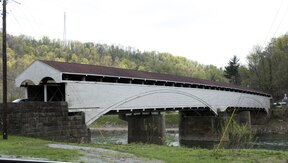
1754:
1746:
1745:
1742:
1739:
1736:
1733:
1728:
1725:
1717:
1716:
1713:
1710:
1707:
1704:
1699:
1696:
1688:
1687:
1684:
1681:
1678:
1675:
1670:
1667:
1659:
1658:
1655:
1652:
1649:
1646:
1641:
1638:
1630:
1629:
1626:
1623:
1620:
1617:
1614:
1610:
1609:
1604:
1599:
1594:
1565:
1562:
1560:
1557:
1487:
1484:
1447:
1444:
1430:, and 4% from
1403:
1400:
1397:
1396:
1388:
1387:
1384:
1382:
1379:
1375:
1374:
1371:
1369:
1366:
1360:
1359:
1356:
1354:
1351:
1345:
1344:
1341:
1339:
1336:
1330:
1329:
1326:
1324:
1321:
1315:
1314:
1311:
1309:
1306:
1300:
1299:
1296:
1294:
1291:
1285:
1284:
1281:
1279:
1276:
1270:
1269:
1266:
1264:
1261:
1255:
1254:
1251:
1249:
1246:
1240:
1239:
1236:
1234:
1231:
1225:
1224:
1221:
1219:
1216:
1210:
1209:
1206:
1204:
1201:
1195:
1194:
1191:
1189:
1186:
1180:
1179:
1176:
1174:
1171:
1165:
1164:
1161:
1159:
1156:
1150:
1149:
1146:
1144:
1141:
1135:
1134:
1131:
1129:
1126:
1120:
1119:
1116:
1114:
1111:
1105:
1104:
1099:
1094:
1089:
1079:
1076:
1072:
1071:
1067:
1066:
1063:Preston County
1060:
1054:
1048:
1042:
1036:
1028:
1025:
1023:
1022:
1021:
1011:
1001:
991:
981:
971:
961:
949:
948:Major highways
946:
941:
877:
874:
870:
869:
865:
864:
863:
862:
857:
852:
847:
842:
837:
827:
826:
825:
813:
812:
811:
810:
809:
799:
798:
797:
787:
786:
785:
774:
773:
772:
757:
752:Main article:
749:
746:
726:
723:
644:
641:
626:covered bridge
580:
577:
575:
572:
495:Barbour County
488:
477:
476:
471:
467:
466:
461:
457:
456:
451:
447:
446:
441:
437:
436:
431:
425:
424:
419:
409:
408:
403:
397:
396:
393:
389:
388:
383:
379:
378:
370:
366:
365:
362:
358:
357:
353:
352:
347:
343:
342:
339:
335:
334:
331:
327:
326:
323:
319:
318:
314:
313:
296:David Strait (
294:
290:
289:
286:
282:
281:
277:
276:
272:
268:
267:
262:
256:
255:
250:
244:
243:
240:
236:
235:
222:
216:
215:
200:
194:
193:
159:
158:
155:
147:
146:
140:
132:
131:
125:
119:
118:
117:
114:
113:
104:
97:
96:
95:
88:
81:
80:
74:
67:
66:
65:
54:
47:
46:
45:
44:
43:
40:
39:
34:
31:
30:
28:Barbour County
27:
20:
15:
9:
6:
4:
3:
2:
5329:
5318:
5315:
5313:
5310:
5308:
5305:
5303:
5300:
5299:
5297:
5284:
5283:
5270:
5264:
5261:
5259:
5256:
5254:
5251:
5249:
5246:
5244:
5241:
5239:
5236:
5234:
5231:
5229:
5226:
5224:
5221:
5219:
5216:
5214:
5211:
5209:
5206:
5204:
5201:
5199:
5196:
5194:
5191:
5189:
5186:
5184:
5181:
5179:
5176:
5174:
5171:
5169:
5166:
5164:
5161:
5159:
5156:
5154:
5151:
5149:
5146:
5144:
5141:
5139:
5136:
5134:
5131:
5129:
5126:
5124:
5121:
5119:
5116:
5114:
5111:
5109:
5106:
5104:
5101:
5099:
5096:
5094:
5091:
5089:
5086:
5084:
5081:
5079:
5076:
5074:
5071:
5069:
5066:
5064:
5061:
5059:
5056:
5054:
5051:
5049:
5046:
5044:
5041:
5039:
5036:
5034:
5031:
5029:
5026:
5024:
5021:
5019:
5016:
5014:
5011:
5009:
5006:
5004:
5001:
4999:
4996:
4994:
4991:
4990:
4988:
4986:
4982:
4976:
4973:
4971:
4968:
4966:
4963:
4961:
4958:
4956:
4953:
4951:
4948:
4946:
4943:
4941:
4938:
4936:
4933:
4931:
4928:
4927:
4925:
4923:
4919:
4913:
4910:
4908:
4905:
4903:
4900:
4898:
4895:
4893:
4890:
4888:
4885:
4883:
4880:
4878:
4875:
4873:
4870:
4868:
4865:
4864:
4862:
4860:
4856:
4850:
4847:
4845:
4842:
4840:
4837:
4835:
4832:
4830:
4827:
4825:
4822:
4820:
4817:
4815:
4814:North Central
4812:
4810:
4807:
4805:
4802:
4800:
4797:
4795:
4792:
4790:
4787:
4785:
4782:
4780:
4777:
4775:
4772:
4771:
4769:
4767:
4763:
4757:
4754:
4752:
4749:
4747:
4744:
4742:
4739:
4738:
4736:
4732:
4724:
4721:
4719:
4716:
4714:
4711:
4710:
4709:
4706:
4704:
4701:
4699:
4696:
4692:
4689:
4688:
4687:
4684:
4682:
4679:
4677:
4674:
4672:
4669:
4667:
4664:
4662:
4659:
4657:
4654:
4653:
4651:
4649:
4645:
4639:
4636:
4634:
4631:
4629:
4626:
4624:
4621:
4617:
4614:
4612:
4609:
4607:
4604:
4603:
4602:
4599:
4597:
4594:
4592:
4589:
4587:
4584:
4582:
4579:
4577:
4574:
4572:
4569:
4567:
4564:
4563:
4561:
4559:
4555:
4550:
4549:
4543:
4539:
4538:West Virginia
4535:
4528:
4523:
4521:
4516:
4514:
4509:
4508:
4505:
4493:
4488:
4486:
4481:
4480:
4477:
4471:
4468:
4467:
4465:
4461:
4455:
4452:
4450:
4447:
4445:
4442:
4440:
4437:
4435:
4432:
4430:
4427:
4425:
4422:
4420:
4417:
4415:
4412:
4410:
4407:
4405:
4402:
4400:
4397:
4395:
4392:
4390:
4387:
4385:
4382:
4380:
4377:
4375:
4372:
4370:
4367:
4365:
4364:Mount Liberty
4362:
4360:
4357:
4355:
4352:
4350:
4347:
4345:
4342:
4340:
4337:
4335:
4332:
4330:
4327:
4325:
4322:
4320:
4317:
4315:
4312:
4310:
4307:
4305:
4302:
4300:
4297:
4295:
4292:
4290:
4287:
4285:
4282:
4280:
4277:
4275:
4272:
4270:
4267:
4265:
4262:
4260:
4257:
4255:
4252:
4249:
4247:
4244:
4242:
4239:
4237:
4234:
4232:
4229:
4227:
4224:
4222:
4219:
4217:
4214:
4212:
4209:
4207:
4204:
4202:
4199:
4197:
4194:
4192:
4189:
4187:
4184:
4182:
4179:
4177:
4174:
4172:
4171:Bear Mountain
4169:
4167:
4164:
4162:
4159:
4157:
4154:
4152:
4149:
4148:
4146:
4144:
4138:
4132:
4129:
4127:
4124:
4123:
4121:
4119:
4115:
4109:
4106:
4104:
4101:
4100:
4098:
4096:
4092:
4086:
4083:
4081:
4078:
4076:
4073:
4071:
4068:
4066:
4063:
4061:
4058:
4056:
4053:
4051:
4048:
4047:
4045:
4043:
4039:
4021:
4018:
4017:
4015:
4013:
4009:
4005:
4004:
3997:
3990:
3985:United States
3982:
3972:
3967:
3965:
3960:
3958:
3953:
3952:
3949:
3935:
3932:
3930:
3928:
3927:Upshur County
3925:
3924:
3921:
3914:
3912:
3911:
3908:
3907:Tucker County
3905:
3897:
3888:
3886:
3883:
3882:
3879:
3872:
3870:
3869:
3866:
3863:
3861:
3860:Taylor County
3858:
3856:
3855:
3850:
3841:
3836:
3834:
3829:
3827:
3822:
3821:
3818:
3812:
3809:
3807:
3804:
3802:
3799:
3797:
3794:
3793:
3784:
3780:
3776:
3773:
3769:
3765:
3761:
3758:
3754:
3750:
3746:
3743:
3739:
3735:
3731:
3728:
3727:
3722:
3718:
3714:
3710:
3707:
3703:
3699:
3695:
3692:
3688:
3686:
3682:
3679:
3675:
3672:
3668:
3664:
3661:
3657:
3653:
3649:
3645:
3642:
3641:
3638:Other sources
3630:
3626:
3621:
3614:
3608:
3593:
3589:
3586:Leip, David.
3582:
3576:
3572:
3568:
3562:
3546:
3542:
3538:
3532:
3516:
3512:
3508:
3502:
3486:
3482:
3478:
3472:
3456:
3452:
3448:
3442:
3440:
3438:
3422:
3418:
3412:
3393:
3387:
3371:
3365:
3349:
3343:
3327:
3321:
3306:
3300:
3284:
3278:
3270:
3266:
3259:
3252:
3251:
3244:
3237:
3231:
3223:
3222:
3214:
3207:
3201:
3194:
3188:
3181:
3177:
3173:
3169:
3165:
3161:
3155:
3147:
3141:
3125:
3121:
3115:
3099:
3095:
3089:
3073:
3067:
3065:
3045:
3039:
3023:
3017:
3001:
2995:
2979:
2973:
2969:
2953:
2950:
2948:
2945:
2943:
2940:
2939:
2938:
2937:West Virginia
2935:
2933:
2930:
2928:
2925:
2923:
2920:
2918:
2915:
2914:
2905:
2902:
2900:
2896:
2893:
2890:
2886:
2882:
2879:
2876:
2872:
2869:
2867:
2866:
2861:
2857:
2853:
2850:
2849:
2843:
2841:
2835:
2833:
2829:
2816:
2813:
2811:
2808:
2806:
2803:
2801:
2798:
2796:
2793:
2791:
2788:
2786:
2783:
2781:
2778:
2776:
2773:
2771:
2768:
2766:
2763:
2761:
2758:
2756:
2753:
2751:
2748:
2746:
2743:
2741:
2738:
2736:
2733:
2731:
2728:
2726:
2725:Mount Liberty
2723:
2721:
2718:
2716:
2713:
2711:
2708:
2706:
2703:
2701:
2698:
2696:
2693:
2691:
2688:
2686:
2683:
2681:
2678:
2676:
2673:
2671:
2668:
2666:
2663:
2661:
2658:
2656:
2653:
2651:
2648:
2646:
2643:
2641:
2638:
2636:
2633:
2631:
2628:
2626:
2623:
2621:
2618:
2616:
2613:
2611:
2608:
2606:
2603:
2601:
2598:
2596:
2593:
2591:
2588:
2585:
2582:
2580:
2577:
2575:
2574:Bear Mountain
2572:
2570:
2567:
2565:
2562:
2560:
2557:
2555:
2552:
2551:
2542:
2539:
2537:
2534:
2533:
2525:
2522:
2520:
2517:
2516:
2508:(county seat)
2507:
2504:
2503:
2494:
2490:
2487:spanning the
2486:
2482:
2477:
2468:
2465:
2461:
2457:
2453:
2439:
2436:
2434:
2431:
2428:
2425:
2422:
2420:
2419:
2415:
2414:
2410:
2407:
2404:
2401:
2399:
2396:
2393:
2391:
2390:
2386:
2385:
2381:
2378:
2375:
2372:
2370:
2367:
2364:
2362:
2361:
2357:
2356:
2352:
2349:
2346:
2343:
2341:
2338:
2335:
2333:
2332:
2328:
2327:
2323:
2320:
2317:
2314:
2312:
2309:
2306:
2304:
2303:
2299:
2298:
2294:
2291:
2289:
2286:
2283:
2280:
2277:
2275:
2274:
2270:
2269:
2265:
2262:
2260:
2257:
2254:
2251:
2248:
2246:
2245:
2241:
2240:
2236:
2233:
2231:
2228:
2225:
2222:
2219:
2217:
2216:
2212:
2211:
2207:
2204:
2201:
2198:
2196:
2193:
2190:
2188:
2187:
2183:
2182:
2178:
2175:
2173:
2170:
2167:
2164:
2161:
2159:
2158:
2154:
2153:
2149:
2146:
2143:
2140:
2138:
2135:
2132:
2130:
2129:
2125:
2124:
2120:
2117:
2114:
2111:
2109:
2106:
2103:
2101:
2100:
2096:
2095:
2091:
2088:
2085:
2082:
2080:
2077:
2074:
2072:
2071:
2067:
2066:
2062:
2059:
2057:
2054:
2051:
2048:
2045:
2043:
2042:
2038:
2037:
2033:
2030:
2028:
2025:
2022:
2019:
2016:
2014:
2013:
2009:
2008:
2004:
2001:
1998:
1995:
1993:
1990:
1987:
1985:
1984:
1980:
1979:
1975:
1972:
1970:
1967:
1964:
1961:
1958:
1956:
1955:
1951:
1950:
1946:
1943:
1941:
1938:
1935:
1932:
1929:
1927:
1926:
1922:
1921:
1917:
1914:
1911:
1908:
1906:
1903:
1900:
1898:
1897:
1893:
1892:
1888:
1885:
1883:
1880:
1877:
1874:
1871:
1869:
1868:
1864:
1863:
1859:
1856:
1854:
1851:
1848:
1845:
1842:
1840:
1839:
1835:
1834:
1830:
1827:
1825:
1822:
1819:
1816:
1813:
1811:
1810:
1806:
1805:
1801:
1798:
1795:
1792:
1790:
1787:
1784:
1782:
1781:
1777:
1776:
1772:
1769:
1766:
1763:
1761:
1758:
1755:
1753:
1752:
1748:
1747:
1743:
1740:
1737:
1734:
1732:
1729:
1726:
1724:
1723:
1719:
1718:
1714:
1711:
1708:
1705:
1703:
1700:
1697:
1695:
1694:
1690:
1689:
1685:
1682:
1679:
1676:
1674:
1671:
1668:
1666:
1665:
1661:
1660:
1656:
1653:
1650:
1647:
1645:
1642:
1639:
1637:
1636:
1632:
1631:
1612:
1611:
1608:
1603:
1598:
1591:
1585:
1583:
1577:
1575:
1571:
1556:
1552:
1548:
1544:
1542:
1538:
1534:
1530:
1526:
1522:
1519:, 0.12% from
1518:
1514:
1510:
1506:
1502:
1498:
1493:
1483:
1481:
1475:
1471:
1469:
1465:
1462:, 13.6% were
1461:
1458:, 22.3% were
1457:
1453:
1443:
1439:
1437:
1433:
1429:
1425:
1421:
1417:
1413:
1409:
1389:
1385:
1383:
1380:
1376:
1372:
1370:
1367:
1365:
1361:
1357:
1355:
1352:
1350:
1346:
1342:
1340:
1337:
1335:
1331:
1327:
1325:
1322:
1320:
1316:
1312:
1310:
1307:
1305:
1301:
1297:
1295:
1292:
1290:
1286:
1282:
1280:
1277:
1275:
1271:
1267:
1265:
1262:
1260:
1256:
1252:
1250:
1247:
1245:
1241:
1237:
1235:
1232:
1230:
1226:
1222:
1220:
1217:
1215:
1211:
1207:
1205:
1202:
1200:
1196:
1192:
1190:
1187:
1185:
1181:
1177:
1175:
1172:
1170:
1166:
1162:
1160:
1157:
1155:
1151:
1147:
1145:
1142:
1140:
1136:
1132:
1130:
1127:
1125:
1121:
1117:
1115:
1112:
1110:
1106:
1086:
1070:
1064:
1061:
1058:
1055:
1052:
1051:Upshur County
1049:
1046:
1043:
1040:
1039:Tucker County
1037:
1034:
1033:Taylor County
1031:
1030:
1024:
1020:
1016:
1012:
1010:
1006:
1002:
1000:
996:
992:
990:
986:
982:
980:
976:
972:
970:
966:
962:
960:
956:
952:
951:
945:
944:
940:
938:
934:
930:
926:
922:
918:
914:
910:
906:
902:
898:
894:
890:
885:
883:
868:
861:
858:
856:
853:
851:
848:
846:
843:
841:
838:
836:
833:
832:
831:
828:
824:
821:
820:
819:
816:
815:
814:
808:
805:
804:
803:
800:
796:
793:
792:
791:
788:
783:
780:
779:
778:
775:
771:
768:
767:
766:
763:
762:
761:
760:
755:
745:
743:
738:
734:
732:
725:Later history
722:
720:
716:
711:
708:
707:Major General
703:
701:
697:
693:
689:
685:
681:
677:
673:
672:first battles
668:
666:
662:
658:
654:
650:
640:
638:
633:
631:
627:
623:
619:
615:
611:
607:
603:
600:
594:
591:
587:
571:
569:
565:
561:
556:
554:
550:
545:
543:
542:Tucker County
539:
535:
531:
527:
523:
519:
515:
511:
507:
506:West Virginia
504:
503:north central
500:
496:
486:
482:
475:
472:
468:
465:
462:
458:
455:
452:
448:
445:
442:
438:
435:
432:
430:
426:
423:
420:
416:
410:
407:
404:
402:
398:
394:
390:
387:
384:
380:
371:
367:
363:
359:
354:
351:
348:
344:
340:
336:
332:
328:
324:
320:
315:
311:
308:Jedd Schola (
305:
299:
295:
291:
287:
283:
278:
275:
273:
269:
266:
263:
261:
257:
254:
251:
249:
245:
242:March 3, 1843
241:
237:
234:
233:West Virginia
223:
221:
217:
213:
212:United States
201:
199:
195:
190:
162:Coordinates:
160:
153:
148:
144:
143:West Virginia
138:
133:
123:
115:
107:
101:
91:
85:
77:
71:
61:
57:
51:
41:
37:
32:
25:
19:
5273:
4992:
4741:Coat of arms
4676:Demographics
4546:
4284:Independence
4269:Hall Station
3999:
3978:
3895:
3778:
3763:
3748:
3733:
3724:
3716:
3712:
3697:
3691:Jim Comstock
3683:
3680:; Baltimore.
3677:
3666:
3643:
3620:
3612:
3607:
3595:. Retrieved
3591:
3581:
3566:
3561:
3549:. Retrieved
3545:the original
3531:
3519:. Retrieved
3515:the original
3501:
3489:. Retrieved
3485:the original
3471:
3459:. Retrieved
3455:the original
3424:. Retrieved
3420:
3411:
3399:. Retrieved
3386:
3374:. Retrieved
3364:
3352:. Retrieved
3342:
3330:. Retrieved
3320:
3308:. Retrieved
3299:
3287:. Retrieved
3277:
3258:
3248:
3243:
3235:
3230:
3220:
3213:
3205:
3200:
3192:
3187:
3174:(Reprinted,
3163:
3154:
3128:. Retrieved
3124:the original
3114:
3102:. Retrieved
3098:the original
3088:
3076:. Retrieved
3048:. Retrieved
3038:
3026:. Retrieved
3016:
3004:. Retrieved
2994:
2982:. Retrieved
2972:
2889:Mother's Day
2863:
2836:
2825:
2795:Vannoys Mill
2665:Independence
2645:Finegan Ford
2454:
2450:
2432:
2416:
2397:
2387:
2368:
2358:
2339:
2329:
2310:
2300:
2287:
2271:
2258:
2242:
2229:
2213:
2194:
2184:
2171:
2155:
2136:
2126:
2107:
2097:
2078:
2068:
2055:
2039:
2026:
2010:
1991:
1981:
1968:
1952:
1939:
1923:
1904:
1894:
1881:
1865:
1852:
1836:
1823:
1807:
1788:
1778:
1759:
1749:
1730:
1720:
1701:
1691:
1672:
1662:
1643:
1633:
1578:
1567:
1553:
1549:
1545:
1489:
1480:poverty line
1476:
1472:
1449:
1440:
1426:, 0.3% from
1405:
1078:Demographics
1068:
886:
879:
866:
829:
817:
801:
789:
776:
764:
739:
735:
728:
704:
669:
646:
636:
634:
595:
582:
557:
546:
520:, which was
494:
493:
480:
429:Area code(s)
181:39.13°N 80°W
18:
4965:Parkersburg
4955:Martinsburg
4859:Metro areas
4819:Ohio Valley
4703:LGBT rights
4611:Delegations
4596:Environment
4463:Ghost towns
4454:West Junior
4424:Valley Bend
4374:Nestorville
4354:Middle Fork
4344:Meadowville
4143:communities
3995:County seat
3160:Maxwell, Hu
3050:November 6,
3028:November 6,
3006:November 6,
2984:November 6,
2871:Larry Groce
2852:Ted Cassidy
2815:West Junior
2785:Valley Bend
2735:Nestorville
2715:Middle Fork
2705:Meadowville
2471:Communities
1574:Alex Mooney
1521:other races
1486:2000 census
1446:2010 census
1428:other races
1408:2020 census
1402:2020 census
1378:2021 (est.)
1065:(northeast)
1053:(southwest)
1047:(southeast)
939:watershed.
696:Confederate
622:county seat
514:county seat
510:2020 census
422:UTC−4 (EDT)
288:Shana Frey
184: /
5296:Categories
5178:Pocahontas
5143:Monongalia
5053:Greenbrier
4960:Morgantown
4950:Huntington
4940:Clarksburg
4935:Charleston
4912:Winchester
4897:Washington
4887:Morgantown
4872:Charleston
4713:Newspapers
4708:Mass media
4601:Government
4548:Charleston
4404:Stringtown
4359:Moatsville
4196:Carrollton
3671:Denver, CO
3656:Dallas, TX
3575:1625852797
3401:January 9,
3376:January 9,
3354:January 9,
3332:January 9,
3310:August 14,
3078:August 14,
2960:References
2760:Stringtown
2720:Moatsville
2600:Carrollton
1625:No.
1619:No.
1613:No.
1602:Democratic
1597:Republican
1541:Appalachia
1537:Melungeons
1490:As of the
1450:As of the
1406:As of the
790:Carrollton
657:referendum
356:Population
280:Government
186:39.13; -80
5173:Pleasants
5168:Pendleton
5083:Jefferson
5058:Hampshire
5033:Doddridge
4867:Bluefield
4686:Education
4616:Elections
4606:Governors
4551:(capital)
4384:Overfield
4334:Mansfield
4294:Kalamazoo
4176:Berryburg
4103:Belington
3660:Paoli, PA
3597:March 27,
3426:April 11,
3195:, pg 474.
3191:Maxwell,
3046:. WBOY-TV
3002:. WBOY-TV
2965:Citations
2740:Overfield
2700:Mansfield
2675:Kalamazoo
2586:(Rangoon)
2579:Berryburg
2519:Belington
1582:Unionists
925:Elk Creek
905:Belington
876:Geography
777:Berryburg
765:Belington
686:and Col.
680:reenacted
643:Civil War
522:chartered
401:Time zone
248:Named for
5198:Randolph
5158:Nicholas
5123:McDowell
5113:Marshall
5073:Harrison
4998:Berkeley
4985:Counties
4975:Wheeling
4945:Fairmont
4907:Wheeling
4844:Southern
4734:Insignia
4698:Gun laws
4656:Abortion
4581:Villages
4389:Peeltree
4329:Longview
4274:Hopewell
4254:Fox Hall
4246:Elk City
4236:Dartmoor
4226:Cove Run
4216:Clemtown
4211:Clements
4186:Brownton
4131:Galloway
4075:Pleasant
4070:Philippi
4020:Philippi
4002:Philippi
3729:, 2000).
3551:April 3,
3521:April 3,
3491:April 3,
3461:April 3,
3289:July 23,
3193:Op. cit.
3162:(1899),
3140:cite web
3130:July 23,
3024:. WVNews
2911:See also
2875:Galloway
2745:Peeltree
2695:Longview
2660:Hopewell
2640:Elk City
2630:Dartmoor
2625:Cove Run
2615:Clemtown
2590:Brownton
2541:Galloway
2506:Philippi
2481:Philippi
2479:View of
1559:Politics
1525:Hispanic
1515:, 0.02%
1511:, 0.26%
1507:, 0.71%
1499:, 0.49%
1460:American
915:and the
830:Philippi
818:Elk City
802:Clemtown
661:Wheeling
653:Virginia
614:Philippi
538:Virginia
518:Philippi
434:304, 681
265:Philippi
60:Philippi
5263:Wyoming
5243:Webster
5213:Summers
5203:Ritchie
5193:Raleigh
5183:Preston
5133:Mineral
5098:Lincoln
5088:Kanawha
5078:Jackson
5063:Hancock
5038:Fayette
5023:Calhoun
5008:Braxton
4993:Barbour
4970:Weirton
4930:Beckley
4766:Regions
4681:Economy
4661:Culture
4648:Society
4633:Symbols
4623:History
4566:Outline
4449:Wilmoth
4414:Talbott
4379:O'Brien
4349:Meriden
4324:Lillian
4279:Huffman
4231:Dantown
4191:Calhoun
4181:Boulder
4151:Adaland
4126:Century
3715:1935),
3104:June 7,
2770:Talbott
2710:Meriden
2595:Calhoun
2584:Boulder
2554:Adaland
2536:Century
2447:Economy
2440:41.26%
2426:16.45%
2405:46.34%
2376:41.75%
2353:11.34%
2347:43.25%
2318:46.46%
2281:45.52%
2252:42.13%
2223:47.66%
2202:48.22%
2165:47.33%
2144:49.92%
2115:45.39%
2086:48.80%
2049:34.74%
2020:47.28%
1999:33.75%
1962:47.01%
1933:46.73%
1912:44.43%
1875:48.28%
1860:16.75%
1846:33.39%
1831:13.49%
1817:35.64%
1796:41.37%
1767:39.22%
1738:38.82%
1709:30.60%
1680:19.98%
1651:21.82%
1468:English
1422:, 0.2%
1418:, 0.2%
1414:, 1.8%
1035:(north)
782:Adaland
731:Grafton
692:Grafton
674:of the
618:platted
574:History
470:Website
372:15,468
239:Founded
198:Country
172:80°00′W
169:39°08′N
90:Adaland
5248:Wetzel
5233:Upshur
5223:Tucker
5218:Taylor
5188:Putnam
5153:Morgan
5148:Monroe
5128:Mercer
5108:Marion
5043:Gilmer
5018:Cabell
5013:Brooke
4628:People
4571:Cities
4558:Topics
4444:Werner
4394:Pepper
4369:Murphy
4339:McLean
4319:Laurel
4314:Lehigh
4299:Kasson
4221:Corley
4206:Claude
4108:Junior
4085:Valley
4050:Barker
3573:
2810:Werner
2750:Pepper
2730:Murphy
2680:Kasson
2620:Corley
2610:Claude
2524:Junior
2464:lumber
2437:1,523
2433:42.29%
2429:1,561
2411:1.43%
2402:1,848
2398:52.23%
2394:2,083
2382:1.67%
2373:2,777
2369:56.58%
2365:3,763
2344:3,188
2340:45.41%
2336:3,347
2324:0.00%
2315:3,491
2311:53.54%
2307:4,023
2295:1.77%
2288:52.71%
2284:4,228
2278:3,652
2266:0.42%
2259:57.45%
2255:5,284
2249:3,875
2237:0.00%
2230:52.34%
2226:5,025
2220:4,576
2208:0.00%
2199:3,718
2195:51.78%
2191:3,993
2179:0.35%
2172:52.32%
2168:4,238
2162:3,834
2150:0.00%
2141:4,489
2137:50.08%
2133:4,504
2121:0.00%
2112:3,707
2108:54.61%
2104:4,460
2092:0.00%
2083:3,818
2079:51.20%
2075:4,006
2063:0.00%
2056:65.26%
2052:4,758
2046:2,533
2034:5.38%
2027:47.34%
2023:3,210
2017:3,206
2005:0.00%
1996:2,258
1992:66.25%
1988:4,432
1976:0.00%
1969:52.99%
1965:3,647
1959:3,235
1947:4.57%
1940:48.70%
1936:3,451
1930:3,311
1918:0.14%
1909:3,108
1905:55.43%
1901:3,877
1889:0.27%
1882:51.45%
1878:3,221
1872:3,023
1857:1,165
1853:49.86%
1849:3,467
1843:2,322
1824:50.87%
1820:3,076
1814:2,155
1802:2.26%
1793:2,503
1789:56.37%
1785:3,411
1773:0.62%
1764:2,610
1760:60.17%
1756:4,004
1744:2.05%
1735:2,419
1731:59.13%
1727:3,685
1715:3.20%
1706:1,768
1702:66.19%
1698:3,824
1686:6.00%
1677:1,222
1673:74.02%
1669:4,527
1657:1.56%
1648:1,457
1644:76.62%
1640:5,116
1529:Latino
1492:census
1456:German
1381:15,468
1368:15,465
1353:16,589
1338:15,557
1323:15,699
1308:16,639
1293:14,030
1283:−21.6%
1278:15,474
1263:19,745
1248:19,869
1233:18,628
1218:18,028
1203:15,858
1188:14,198
1173:12,702
1158:11,870
1143:10,312
1088:Census
1069:
1059:(west)
1041:(east)
909:Junior
907:, and
867:
599:jurist
590:Indian
562:), an
499:county
364:15,465
230:
209:
36:County
5238:Wayne
5228:Tyler
5208:Roane
5138:Mingo
5118:Mason
5103:Logan
5093:Lewis
5068:Hardy
5048:Grant
5003:Boone
4751:Motto
4718:Radio
4671:Crime
4576:Towns
4534:State
4434:Volga
4419:Union
4309:Lantz
4289:Jones
4250:Flora
4166:Audra
4161:Arden
4095:Towns
4080:Union
4065:Glade
3395:(PDF)
2899:Audra
2860:Thing
2858:and "
2856:Lurch
2840:wards
2800:Volga
2780:Union
2690:Lantz
2670:Jones
2569:Audra
2564:Arden
2513:Towns
1593:Year
1576:(R).
1513:Asian
1501:Black
1497:White
1464:Irish
1420:Asian
1412:White
1373:−6.8%
1343:−0.9%
1328:−5.6%
1313:18.6%
1298:−9.3%
1268:−0.6%
1223:13.7%
1208:11.7%
1193:11.8%
1163:15.1%
1148:15.1%
1133:−0.5%
1128:8,958
1113:9,005
655:in a
497:is a
220:State
5258:Wood
5253:Wirt
5163:Ohio
5028:Clay
4756:Seal
4746:Flag
4409:Tacy
4304:Kirt
4264:Hall
4259:Gage
4241:Dent
4156:Adma
4118:CDPs
4055:Cove
4012:City
3658:and
3599:2018
3571:ISBN
3553:2016
3523:2016
3493:2016
3463:2016
3428:2023
3403:2014
3378:2014
3356:2014
3334:2014
3312:2022
3291:2015
3146:link
3132:2013
3106:2011
3080:2022
3052:2023
3030:2023
3008:2023
2986:2023
2765:Tacy
2685:Kirt
2655:Hall
2650:Gage
2635:Dent
2559:Adma
2500:City
2423:607
2418:1912
2389:1916
2379:111
2360:1920
2350:836
2331:1924
2302:1928
2292:142
2273:1932
2244:1936
2215:1940
2186:1944
2157:1948
2128:1952
2099:1956
2070:1960
2041:1964
2031:365
2012:1968
1983:1972
1954:1976
1944:324
1925:1980
1896:1984
1867:1988
1838:1992
1828:816
1809:1996
1799:137
1780:2000
1751:2004
1741:128
1722:2008
1712:185
1693:2012
1683:367
1664:2016
1654:104
1635:2020
1386:0.0%
1364:2020
1358:6.6%
1349:2010
1334:2000
1319:1990
1304:1980
1289:1970
1274:1960
1259:1950
1253:6.7%
1244:1940
1238:3.3%
1229:1930
1214:1920
1199:1910
1184:1900
1178:7.0%
1169:1890
1154:1880
1139:1870
1124:1860
1109:1850
1097:Note
1092:Pop.
547:The
464:68th
454:11th
386:36th
350:37th
317:Area
260:Seat
126:Flag
4536:of
4060:Elk
3713:ca.
3269:CNN
2408:57
2263:39
2176:28
1915:10
1886:17
1770:41
1527:or
1503:or
516:is
501:in
444:2nd
415:DST
58:in
5298::
4723:TV
3998::
3983:,
3781:,
3770:,
3755::
3751:,
3740::
3736:,
3704::
3700:,
3654:,
3650:,
3627:,
3590:.
3569:,
3539:.
3509:.
3479:.
3449:.
3436:^
3419:.
3267:.
3178:,
3170:,
3166:,
3142:}}
3138:{{
3063:^
2321:0
2234:0
2205:0
2147:0
2118:0
2089:0
2060:0
2002:0
1973:0
1628:%
1543:.
1470:.
1434:.
1102:%±
927:.
555:.
4526:e
4519:t
4512:v
3970:e
3963:t
3956:v
3839:e
3832:t
3825:v
3774:.
3759:.
3744:.
3708:.
3673:.
3662:.
3601:.
3555:.
3525:.
3495:.
3465:.
3430:.
3405:.
3380:.
3358:.
3336:.
3314:.
3293:.
3271:.
3148:)
3134:.
3108:.
3082:.
3054:.
3032:.
3010:.
2988:.
1622:%
1616:%
1118:—
417:)
312:)
310:R
306:)
304:R
300:)
298:R
Text is available under the Creative Commons Attribution-ShareAlike License. Additional terms may apply.