116:
100:
916:
85:
75:
702:
972:
60:
340:
691:
660:
348:
864:
123:
472:) characterized by warm summers and cold winters with heavy snowfall. The average annual temperature in Aizumisato is 13.1 °C. The average annual rainfall is 1320 mm with September as the wettest month. The temperatures are highest on average in August, at around 24.8 °C, and lowest in January, at around −1.4 °C.
639:
Aizumisato has five public elementary schools and three public junior high schools operated by the town government. The town has one public high school operated by the
Fukushima Prefectural Board of Education.
147:
115:
99:
915:
791:
1374:
839:
1416:
868:
883:
17:
1128:
905:
1253:
84:
971:
736:, also in Fukushima Prefecture. This is a renewal of the relationship Niitsuru had with Naraha prior to the merger.
607:
in
Fukushima Prefecture. The town of Aizumisato was created on October 1, 2005 with the merger of the two towns of
1421:
1226:
1204:
1155:
74:
620:
604:
220:
677:
1307:
395:
of 73 persons per km. The total area of the town was 276.33 square kilometres (106.69 sq mi).
1324:
1081:
1047:
1187:
933:
766:
465:
1341:
1059:
705:
433:
191:
179:
1361:
898:
281:
612:
913:
717:
59:
1192:
1011:
608:
1273:
1236:
480:
Per
Japanese census data, the population of Aizumisato has declined over the past 70 years.
453:
1356:
1263:
1246:
1143:
1016:
943:
919:
438:
380:
208:
203:
8:
1290:
1268:
1180:
1170:
1165:
1148:
1138:
1121:
1116:
1064:
1026:
1006:
996:
788:
694:
673:
616:
407:
region, in west-central
Fukushima Prefecture on the southwestern edge of the Aizu Basin.
270:
1300:
1106:
1052:
777:
448:
1312:
1295:
1214:
1160:
1111:
891:
443:
392:
215:
1021:
1346:
1329:
1317:
1258:
1241:
1219:
1197:
1175:
1133:
1101:
1091:
1086:
1074:
1031:
733:
600:
1280:
836:
1096:
1069:
956:
951:
928:
811:
196:
991:
843:
795:
1334:
588:
376:
291:
50:
1410:
986:
162:
149:
1001:
875:
418:
329:
752:
667:
592:
1395:
1390:
961:
1351:
1231:
596:
388:
1209:
347:
339:
261:
319:
3163 Miyakita, Aizumisato-machi, Ōnuma-gun, Fukushima-ken 969-6292
663:
659:
301:
863:
266:
384:
184:
1385:
732:
Aizumisato has a sister-city relationship with the town of
404:
387:. As of 1 March 2020, the town had an estimated
631:
The economy of
Aizumisato is dominated by agriculture.
587:
The area of present-day
Aizumisato was part of ancient
403:
Aizumisato is located in the eastern portion of the
411:
Mountains: Mount Hakase, Mount
Myojindake (1074 m)
1408:
850:), town web site, retrieved on December 22, 2008
366:
360:
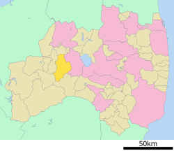
104:Location of Aizumisato in Fukushima Prefecture
38:
899:
424:
644:Fukushima Prefectural Aizumisato High School
906:
892:
818:(in Japanese). Agency for Cultural Affairs
346:
338:
1375:List of mergers in Fukushima Prefecture
235:276.33 km (106.69 sq mi)
14:
1409:
497:
887:
804:
711:
391:of 20,092 in 7306 households and a
753:Aizumisato official town statistics
591:and formed part of the holdings of
24:
492:
122:
25:
1433:
857:
798:. Retrieved on 22 December 2008.
648:
970:
914:
862:
778:Aizumisato population statistics
727:
700:
689:
658:
121:
114:
98:
83:
73:
58:
720:ruins, a National Historic Site
475:
848:Shimai yūkō toshi – Aizumisato
830:
782:
771:
760:
746:
603:, it was organized as part of
13:
1:
1417:Towns in Fukushima Prefecture
739:
634:
398:
7:
367:
10:
1438:
683:
653:
626:
582:
459:
425:Neighboring municipalities
1372:
1129:Higashishirakawa District
1040:
979:
968:
942:
926:
510:—
466:Humid continental climate
361:
323:
315:
307:
297:
287:
277:
260:
252:
244:
239:
231:
226:
214:
202:
190:
178:
143:
109:
97:
69:
57:
48:
39:
32:
816:Cultural Heritage Online
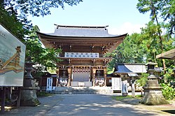
351:Central Aizumisato scene
36:
1254:Nishishirakawa District
767:Aizumisato climate data
706:National Route 401
282:Styphnolobium japonicum
163:37.459861°N 139.84111°E
718:Mukaihaguroyama Castle
352:
344:
256:73/km (190/sq mi)
1422:Aizumisato, Fukushima
871:at Wikimedia Commons
869:Aizumisato, Fukushima
484:Historical population
429:Fukushima Prefecture
350:
342:
27:Town in Tōhoku, Japan
18:Aizumisato, Fukushima
920:Fukushima Prefecture
381:Fukushima Prefecture
343:Aizumisato Town Hall
253: • Density
168:37.459861; 139.84111
1227:Minamiaizu District
695:Ban-etsu Expressway
615:and the village of
485:
271:Japan Standard Time
159: /
842:2009-02-27 at the
794:2008-08-13 at the
483:
393:population density
353:
345:
245: • Total
232: • Total
1404:
1403:
1205:Kawanuma District
1156:Ishikawa District
867:Media related to
712:Local attractions
601:Meiji Restoration
580:
579:
464:Aizumisato has a
414:Rivers: Aka River
337:
336:
308:Phone number
16:(Redirected from
1429:
1382:
974:
937:
918:
908:
901:
894:
885:
884:
880:
876:Official Website
866:
851:
834:
828:
827:
825:
823:
808:
802:
801:
786:
780:
775:
769:
764:
758:
757:
750:
723:Sakurdari Kannon
704:
703:
693:
692:
662:
499:
494:
486:
482:
374:
373:
370:
368:Aizumisato-machi
364:
363:
333:
332:
330:Official website
174:
173:
171:
170:
169:
164:
160:
157:
156:
155:
152:
125:
124:
118:
102:
87:
77:
62:
43:
42:
41:
30:
29:
21:
1437:
1436:
1432:
1431:
1430:
1428:
1427:
1426:
1407:
1406:
1405:
1400:
1380:
1377:
1368:
1325:Tamura District
1082:Futaba District
1048:Adachi District
1036:
975:
966:
938:
931:
922:
912:
878:
860:
855:
854:
844:Wayback Machine
835:
831:
821:
819:
810:
809:
805:
799:
796:Wayback Machine
787:
783:
776:
772:
765:
761:
755:
751:
747:
742:
730:
714:
701:
690:
686:
656:
651:
637:
629:
585:
478:
462:
427:
401:
371:
358:
328:
327:
167:
165:
161:
158:
153:
150:
148:
146:
145:
139:
138:
137:
136:
133:
132:
131:
130:
126:
105:
93:
92:
91:
90:
81:
80:
65:
53:
44:
37:
35:
28:
23:
22:
15:
12:
11:
5:
1435:
1425:
1424:
1419:
1402:
1401:
1399:
1398:
1393:
1388:
1383:
1373:
1370:
1369:
1367:
1366:
1365:
1364:
1359:
1354:
1349:
1339:
1338:
1337:
1332:
1322:
1321:
1320:
1315:
1305:
1304:
1303:
1298:
1293:
1288:
1281:Ōnuma District
1278:
1277:
1276:
1271:
1266:
1261:
1251:
1250:
1249:
1244:
1239:
1234:
1224:
1223:
1222:
1217:
1212:
1202:
1201:
1200:
1195:
1188:Iwase District
1185:
1184:
1183:
1178:
1173:
1168:
1163:
1153:
1152:
1151:
1146:
1141:
1136:
1126:
1125:
1124:
1119:
1114:
1109:
1104:
1099:
1094:
1089:
1079:
1078:
1077:
1072:
1067:
1057:
1056:
1055:
1044:
1042:
1038:
1037:
1035:
1034:
1029:
1024:
1019:
1014:
1009:
1004:
999:
994:
989:
983:
981:
977:
976:
969:
967:
965:
964:
959:
954:
948:
946:
940:
939:
927:
924:
923:
911:
910:
903:
896:
888:
882:
881:
859:
858:External links
856:
853:
852:
837:姉妹友好都市 – 会津美里町
829:
803:
789:"合併後の住居表示について"
781:
770:
759:
744:
743:
741:
738:
729:
726:
725:
724:
721:
713:
710:
709:
708:
698:
685:
682:
681:
680:
655:
652:
650:
649:Transportation
647:
646:
645:
636:
633:
628:
625:
621:Ōnuma District
605:Ōnuma District
589:Mutsu Province
584:
581:
578:
577:
574:
571:
567:
566:
563:
560:
556:
555:
552:
549:
545:
544:
541:
538:
534:
533:
530:
527:
523:
522:
519:
516:
512:
511:
508:
505:
501:
500:
495:
490:
477:
474:
461:
458:
457:
456:
451:
446:
441:
436:
426:
423:
422:
421:
415:
412:
400:
397:
335:
334:
325:
321:
320:
317:
313:
312:
309:
305:
304:
299:
295:
294:
292:Iris sanguinea
289:
285:
284:
279:
275:
274:
264:
258:
257:
254:
250:
249:
246:
242:
241:
237:
236:
233:
229:
228:
224:
223:
218:
212:
211:
206:
200:
199:
194:
188:
187:
182:
176:
175:
141:
140:
134:
128:
127:
120:
119:
113:
112:
111:
110:
107:
106:
103:
95:
94:
88:
82:
78:
72:
71:
70:
67:
66:
64:Isasumi Shrine
63:
55:
54:
49:
46:
45:
33:
26:
9:
6:
4:
3:
2:
1434:
1423:
1420:
1418:
1415:
1414:
1412:
1397:
1394:
1392:
1389:
1387:
1384:
1379:
1378:
1376:
1371:
1363:
1360:
1358:
1355:
1353:
1350:
1348:
1345:
1344:
1343:
1342:Yama District
1340:
1336:
1333:
1331:
1328:
1327:
1326:
1323:
1319:
1316:
1314:
1311:
1310:
1309:
1308:Sōma District
1306:
1302:
1299:
1297:
1294:
1292:
1289:
1287:
1284:
1283:
1282:
1279:
1275:
1272:
1270:
1267:
1265:
1262:
1260:
1257:
1256:
1255:
1252:
1248:
1245:
1243:
1240:
1238:
1235:
1233:
1230:
1229:
1228:
1225:
1221:
1218:
1216:
1213:
1211:
1208:
1207:
1206:
1203:
1199:
1196:
1194:
1191:
1190:
1189:
1186:
1182:
1179:
1177:
1174:
1172:
1169:
1167:
1164:
1162:
1159:
1158:
1157:
1154:
1150:
1147:
1145:
1142:
1140:
1137:
1135:
1132:
1131:
1130:
1127:
1123:
1120:
1118:
1115:
1113:
1110:
1108:
1105:
1103:
1100:
1098:
1095:
1093:
1090:
1088:
1085:
1084:
1083:
1080:
1076:
1073:
1071:
1068:
1066:
1063:
1062:
1061:
1060:Date District
1058:
1054:
1051:
1050:
1049:
1046:
1045:
1043:
1039:
1033:
1030:
1028:
1025:
1023:
1020:
1018:
1015:
1013:
1010:
1008:
1005:
1003:
1000:
998:
995:
993:
990:
988:
987:Aizuwakamatsu
985:
984:
982:
978:
973:
963:
960:
958:
955:
953:
950:
949:
947:
945:
941:
935:
930:
925:
921:
917:
909:
904:
902:
897:
895:
890:
889:
886:
879:(in Japanese)
877:
874:
873:
872:
870:
865:
849:
845:
841:
838:
833:
817:
813:
807:
800:(in Japanese)
797:
793:
790:
785:
779:
774:
768:
763:
756:(in Japanese)
754:
749:
745:
737:
735:
728:Sister cities
722:
719:
716:
715:
707:
699:
697:– Niitsuru PA
696:
688:
687:
679:
675:
672:
671:
670:
669:
665:
661:
643:
642:
641:
632:
624:
622:
618:
614:
610:
606:
602:
598:
594:
590:
575:
572:
569:
568:
564:
561:
558:
557:
553:
550:
547:
546:
542:
539:
536:
535:
531:
528:
525:
524:
520:
517:
514:
513:
509:
506:
503:
502:
496:
491:
488:
487:
481:
473:
471:
467:
455:
452:
450:
447:
445:
442:
440:
437:
435:
434:Aizuwakamatsu
432:
431:
430:
420:
416:
413:
410:
409:
408:
406:
396:
394:
390:
386:
382:
378:
369:
357:
349:
341:
331:
326:
322:
318:
314:
311:0242-55-1122
310:
306:
303:
300:
296:
293:
290:
286:
283:
280:
276:
272:
268:
265:
263:
259:
255:
251:
247:
243:
238:
234:
230:
225:
222:
219:
217:
213:
210:
207:
205:
201:
198:
195:
193:
189:
186:
183:
181:
177:
172:
144:Coordinates:
142:
117:
108:
101:
96:
86:
76:
68:
61:
56:
52:
47:
31:
19:
1362:Kitashiobara
1285:
861:
847:
832:
820:. Retrieved
815:
806:
784:
773:
762:
748:
731:
657:
638:
630:
599:. After the
586:
479:
476:Demographics
469:
463:
428:
419:Miyagawa Dam
402:
355:
354:
151:37°27′35.5″N
944:Core cities
674:Aizu-Takada
668:Tadami Line
619:, all from
595:during the
593:Aizu Domain
379:located in
166: /
154:139°50′28″E
1411:Categories
1352:Inawashiro
1286:Aizumisato
1232:Minamiaizu
1193:Kagamiishi
1012:Nihonmatsu
1002:Minamisōma
822:23 October
740:References
609:Aizutakada
597:Edo period
389:population
356:Aizumisato
240:Population
204:Prefecture
129:Aizumisato
34:Aizumisato
1357:Nishiaizu
1264:Izumizaki
1247:Hinoemata
1210:Aizubange
1144:Yamatsuri
1041:Districts
1017:Shirakawa
952:Fukushima
929:Fukushima
635:Education
613:Aizuhongō
439:Aizubange
399:Geography
262:Time zone
209:Fukushima
1396:Nakadōri
1391:Hamadōri
1291:Kaneyama
1269:Nakajima
1181:Tamakawa
1171:Ishikawa
1166:Furudono
1149:Samegawa
1139:Tanagura
1122:Kawauchi
1117:Katsurao
1065:Kawamata
1027:Sukagawa
1007:Motomiya
997:Kitakata
962:Kōriyama
840:Archived
812:"向羽黒山城跡"
792:Archived
617:Niitsuru
468:(Köppen
288:– Flower
216:District
1381:Regions
1313:Shinchi
1296:Mishima
1274:Nishigō
1237:Shimogō
1215:Yanaizu
1161:Asakawa
1112:Tomioka
934:capital
684:Highway
678:Negishi
664:JR East
654:Railway
627:Economy
583:History
460:Climate
454:Shimogō
444:Yanaizu
417:Lakes:
324:Website
316:Address
302:Wagtail
180:Country
1347:Bandai
1330:Miharu
1318:Iitate
1259:Yabuki
1242:Tadami
1220:Yugawa
1198:Ten-ei
1176:Hirata
1134:Hanawa
1102:Naraha
1092:Hirono
1087:Futaba
1075:Kunimi
1032:Tamura
980:Cities
734:Naraha
576:−16.4%
573:22,727
562:27,172
551:27,211
540:27,945
532:−16.7%
529:30,036
518:36,073
507:38,522
298:– Bird
278:– Tree
248:20,092
197:Tōhoku
192:Region
135:
1301:Shōwa
1107:Ōkuma
1097:Namie
1070:Koori
1053:Ōtama
957:Iwaki
570:2010
565:−0.1%
559:2000
554:−2.6%
548:1990
543:−7.0%
537:1980
526:1970
521:−6.4%
515:1960
504:1950
449:Shōwa
385:Japan
375:is a
362:会津美里町
267:UTC+9
221:Ōnuma
185:Japan
40:会津美里町
1386:Aizu
1022:Sōma
992:Date
824:2018
611:and
493:Pop.
489:Year
405:Aizu
377:town
227:Area
89:Seal
79:Flag
51:Town
1335:Ono
470:Dfb
1413::
814:.
676:–
666:–
623:.
498:±%
383:,
365:,
936:)
932:(
907:e
900:t
893:v
846:(
826:.
372:)
359:(
273:)
269:(
20:)
Text is available under the Creative Commons Attribution-ShareAlike License. Additional terms may apply.


