54:
576:
31:
61:
215:
357:, of which Wardley is the start of. The M60 motorway passes through the area, with links at Junction 14 (from A580 west, no access to A580 east or M60 clockwise) and the M60 and A666(M) meet at Worsley Braided Interchange (at M60 J15 and A666(M) J1). The
92:
440:
store. The Brook Tavern, as its name implied, stood on the
Worsley side of Sindsley Brook, the historic boundary between Swinton and Worsley. The Morning Star is run by
119:
617:
416:
on
Moorside Road, close to the junction with Chorley Road (A6), Swinton. Until 1974 the station was known as Moorside and Wardley. The station is on the
436:
Wardley once had three public houses, the
Morning Star, Red Lion and Brook Tavern, but the last has now closed down and been converted into a small
281:
239:
462:
39:
526:
646:
53:
232:
610:
201:
557:
641:
273:
603:
417:
227:
386:
458:
263:
189:
155:
421:
636:
374:
85:
425:
244:
498:
378:
338:
394:
591:
549:
The Lore of the Land: A Guide to
England's Legends, from Spring-heeled Jack to the Witches of Warboys
268:
220:
385:. There is also an hourly daytime only Monday to Saturday service (484) through Wardley which links
441:
413:
169:
361:(Manchester Road) also passes through the district with frequent bus services (36 and 37) linking
491:
476:
101:
8:
575:
583:
326:
145:
137:
127:
74:
553:
506:
483:
469:
358:
547:
322:
194:
109:
587:
451:
630:
296:
283:
447:
354:
35:
402:
382:
473:
406:
390:
366:
350:
330:
179:
370:
334:
161:
454:
398:
362:
318:
30:
437:
510:
487:
628:
546:Westwood, Jennifer; Simpson, Jacqueline (2006).
545:
353:passes through the area, and also links to the
472:lies between the A6 (Manchester Road) and the
611:
618:
604:
629:
431:
570:
13:
647:Greater Manchester geography stubs
465:, also known as Wardley Cemetery.
14:
658:
574:
527:St Ambrose Barlow RC High School
59:
52:
29:
60:
539:
1:
532:
590:. You can help Knowledge by
513:". The name was recorded as
344:
7:
642:Areas of Greater Manchester
463:St Mary's Catholic Cemetery
351:A580 "East Lancashire Road"
86:OS grid reference
18:Human settlement in England
10:
663:
569:
412:The district is served by
520:
254:
250:
238:
226:
214:
210:
200:
188:
178:
168:
154:
136:
118:
102:Metropolitan borough
100:
84:
47:
28:
23:
552:. Penguin. p. 410.
450:is the residence of the
414:Moorside railway station
120:Metropolitan county
586:location article is a
387:Salford Royal Hospital
329:, England. It borders
190:Postcode district
442:Joseph Holt's Brewery
637:Geography of Salford
477:East Lancashire Road
461:. Adjacent to it is
401:, Wardley, Swinton,
170:Sovereign state
42:medieval manor house
432:General information
418:Manchester Victoria
293: /
584:Greater Manchester
501:, protection" and
327:Greater Manchester
297:53.5190°N 2.3551°W
274:Greater Manchester
233:Greater Manchester
221:Greater Manchester
202:Dialling code
128:Greater Manchester
75:Greater Manchester
599:
598:
559:978-0-14-102103-4
470:Industrial Estate
312:
311:
654:
620:
613:
606:
578:
571:
564:
563:
543:
308:
307:
305:
304:
303:
302:53.5190; -2.3551
298:
294:
291:
290:
289:
286:
260:
164:
96:
95:
73:Location within
63:
62:
56:
33:
21:
20:
662:
661:
657:
656:
655:
653:
652:
651:
627:
626:
625:
624:
568:
567:
560:
544:
540:
535:
523:
482:Wardley means "
434:
405:, Agecroft and
347:
323:City of Salford
301:
299:
295:
292:
287:
284:
282:
280:
279:
278:
258:
160:
150:
132:
114:
91:
90:
80:
79:
78:
77:
71:
70:
69:
68:
64:
43:
19:
12:
11:
5:
660:
650:
649:
644:
639:
623:
622:
615:
608:
600:
597:
596:
579:
566:
565:
558:
537:
536:
534:
531:
530:
529:
522:
519:
452:Roman Catholic
433:
430:
373:with Swinton,
346:
343:
310:
309:
277:
276:
271:
266:
261:
259:List of places
255:
252:
251:
248:
247:
242:
236:
235:
230:
224:
223:
218:
212:
211:
208:
207:
204:
198:
197:
192:
186:
185:
182:
176:
175:
174:United Kingdom
172:
166:
165:
158:
152:
151:
149:
148:
142:
140:
134:
133:
131:
130:
124:
122:
116:
115:
113:
112:
106:
104:
98:
97:
88:
82:
81:
72:
66:
65:
58:
57:
51:
50:
49:
48:
45:
44:
40:Grade I listed
34:
26:
25:
17:
9:
6:
4:
3:
2:
659:
648:
645:
643:
640:
638:
635:
634:
632:
621:
616:
614:
609:
607:
602:
601:
595:
593:
589:
585:
580:
577:
573:
572:
561:
555:
551:
550:
542:
538:
528:
525:
524:
518:
516:
512:
508:
504:
500:
496:
493:
489:
485:
480:
478:
475:
471:
466:
464:
460:
456:
453:
449:
445:
443:
439:
429:
427:
423:
419:
415:
410:
408:
404:
400:
396:
392:
388:
384:
380:
376:
372:
368:
364:
360:
356:
352:
342:
340:
336:
332:
328:
324:
320:
316:
306:
275:
272:
270:
267:
265:
262:
257:
256:
253:
249:
246:
243:
241:
237:
234:
231:
229:
225:
222:
219:
217:
213:
209:
205:
203:
199:
196:
193:
191:
187:
183:
181:
177:
173:
171:
167:
163:
159:
157:
153:
147:
144:
143:
141:
139:
135:
129:
126:
125:
123:
121:
117:
111:
108:
107:
105:
103:
99:
94:
89:
87:
83:
76:
55:
46:
41:
37:
32:
27:
22:
16:
592:expanding it
581:
548:
541:
514:
502:
494:
481:
467:
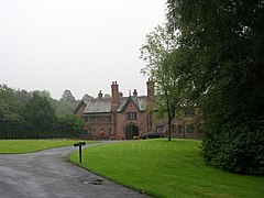
448:Wardley Hall
446:
435:
411:
355:M61 motorway
348:
321:area of the
314:
313:
36:Wardley Hall
15:
515:Weardeleige
492:Old English
300: /
631:Categories
533:References
403:Pendlebury
383:Manchester
285:53°31′08″N
245:North West
184:MANCHESTER
146:North West
517:in 1148.
424:line via
407:Rainsough
391:Prestwich
375:Pendleton
367:Farnworth
345:Transport
331:Linnyshaw
288:2°21′18″W
240:Ambulance
180:Post town
507:clearing
490:", from
484:clearing
468:Wardley
426:Atherton
319:suburban
195:M27, M28
93:SD765025
459:Salford
379:Salford
371:Walkden
359:A6 road
339:Swinton
335:Walkden
315:Wardley
269:England
162:England
156:Country
110:Salford
67:Wardley
24:Wardley
556:
521:School
455:bishop
399:Monton
395:Eccles
363:Bolton
216:Police
138:Region
582:This
495:weard
486:by a
438:Tesco
422:Wigan
389:with
325:, in
317:is a
38:is a
588:stub
554:ISBN
511:wood
503:leāh
499:ward
488:fort
474:A580
393:via
381:and
369:and
349:The
337:and
228:Fire
206:0161
457:of
420:to
633::
509:,
479:.
444:.
428:.
409:.
397:,
377:,
365:,
341:.
333:,
264:UK
619:e
612:t
605:v
594:.
562:.
505:"
497:"
Text is available under the Creative Commons Attribution-ShareAlike License. Additional terms may apply.

