40:
192:
52:
674:
404:
The lower
Urubamba River was mapped for the first time in 1934 by Edward Kellog Strong III. He and two friends from Palo Alto, California, Art Post and Gain Allan John, navigated the river with its ferocious rapids by canoe and balsa rafts provided by the indigenous people. The mapping was done at
408:
The map was turned over to the military when the boys arrived in
Iquitos. It remained the only map of the river until mapping by satellite became possible many years later. The names and places on the latest map came from the original map drawn by Edward Strong.
582:
Radio San
Gabriel, "Instituto Radiofonico de Promoción Aymara" (IRPA) 1993, Republicado por Instituto de las Lenguas y Literaturas Andinas-Amazónicas (ILLLA-A) 2011, Transcripción del Vocabulario de la Lengua Aymara, P.
643:
358:
101:
699:
549:
513:
338:) is relatively undeveloped and features a significant indigenous population consisting of the Campa tribes, principally the
323:
714:
507:
499:
704:
678:
709:
527:
415:, a British geologist, drowned in the river on June 2, 1932 while on a geological expedition to the Andes.
405:
the request of the
Peruvian military when they heard of the expedition planned by the three 18-year-olds.
275:
The
Urubamba is divided into the Upper Urubamba and the Lower Urubamba, the dividing feature being the
528:"MINISTERIO DE TRABAJO DESTINARA S/.5.6 MILLONES PARA LA CAPACITACION DE JOVENES EN LA REGION CUSCO"
233:
597:
Adoratorio muy célebre entre
Sicuana y Chungara. Significa casa del Sol, según los indios bárbaros.
694:
606:
Adoratorio dedicado al Sol u otros ídolos. / El Sol como antiguamente decían y ahora dicen inti.
39:
644:"Persiste el rechazo a la hidroeléctrica Salcca Pucara en las comunidades campesinas de Canchis"
261:
298:) valley features a high population and extensive irrigation works. A number of ruins of the
8:
412:
347:
264:
pass. It flows north-north-west for 724 km (450 mi) before coalescing with the
265:
584:
503:
276:
249:
167:
493:
351:
211:
191:
257:
226:
550:"Diccionario: Quechua - Español - Quechua, Simi Taqe: Qheswa - Español - Qheswa"
559:. Gobierno Regional del Cusco, Perú: Academía Mayor de la Lengua Quechua. 2005.
688:
472:
374:
360:
303:
269:
116:
103:
87:
307:
237:
183:
343:
339:
299:
253:
179:
82:
319:
315:
311:
280:
236:, the name changes to Urubamba. A partially navigable headwater of the
17:
163:
51:
439:
159:
673:
283:
245:
241:
196:
492:
Ziesler, R.; Ardizzone, G.D. (1979). "Amazon River System".
286:, where the river narrows to a width of 45 metres (148 ft).
630:
Estudio linea base ambiental de la cuenca del río
Vilcanota
218:
70:
16:
For the river
Willkamayu in the Ayacucho Region, Peru, see
500:
Food and
Agriculture Organization of the United Nations
44:
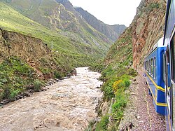
Urubamba River seen from train en route to Machu Picchu
350:. The main settlement in the region is the town of
346:. The economy is based on forestry and the nearby
686:
587:1612 (Spanish-Aymara-Aymara-Spanish dictionary)
491:
530:. Ministerio de Trabajo y Promoción del Empleo
624:
622:
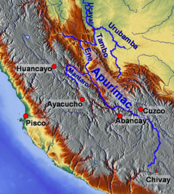
56:Map of larger rivers in south-central Peru
642:Salcedo, José Víctor (9 December 2011).
190:
641:
619:
576:
557:Diccionario Quechua - Español - Quechua
687:
326:is associated with the river as well.
232:, for "house of the sun"). Within the
520:
516:from the original on 8 November 2014.
399:
217:, for "sacred river") is a river in
542:
324:Salcca-Pucara hydroelectric project
13:
495:The Inland waters of Latin America
485:
14:
726:
666:
354:. (Sepahua River coordinates are
329:
289:
248:. It originates on the slopes of
700:Tributaries of the Ucayali River
672:
570:s. Geog. (Río Sagrado) Vilcanota
50:
38:
635:
632:, Lima-Peru, 2010 (in Spanish)
418:
306:, including the Incan city of
95: • coordinates
1:
478:
77:Physical characteristics
240:, the Urubamba rises in the
7:
466:
10:
731:
15:
628:Ministerio del Ambiente,
173:
153:
145:
140:
136:724 km (450 mi)
132:
93:
81:
76:
66:
61:
49:
37:
28:
715:Rivers of Ucayali Region
433:Ste. Teresa or Salcantay
221:. Upstream it is called
195:The Urubamba River near
175: • right
155: • left
705:Rivers of Cusco Region
613:Nombre. Casa cubierta.
234:La Convención Province
199:
710:Rivers of Puno Region
375:11.14944°S 73.04861°W
194:
117:10.70194°S 73.75417°W
681:at Wikimedia Commons
380:-11.14944; -73.04861
334:The Lower Urubamba (
294:The Upper Urubamba (
244:to the southeast of
122:-10.70194; -73.75417
650:(in Spanish). Cusco
413:John Walter Gregory
370: /
348:Camisea Gas Project
141:Basin features
113: /
400:1934 first mapping
200:
677:Media related to
585:Ludovico Bertonio
342:(Matsigenka) and
277:Pongo de Mainique
189:
188:
722:
676:
660:
659:
657:
655:
639:
633:
626:
617:
580:
574:
560:
554:
546:
540:
539:
537:
535:
524:
518:
517:
489:
396:
394:
393:
391:
390:
389:
387:
382:
381:
376:
371:
368:
367:
366:
363:
176:
156:
128:
127:
125:
124:
123:
118:
114:
111:
110:
109:
106:
54:
42:
26:
25:
730:
729:
725:
724:
723:
721:
720:
719:
685:
684:
669:
664:
663:
653:
651:
640:
636:
627:
620:
581:
577:
552:
548:
547:
543:
533:
531:
526:
525:
521:
510:
490:
486:
481:
469:
421:
402:
385:
383:
379:
377:
373:
372:
369:
364:
361:
359:
357:
356:
355:
332:
292:
258:Melgar Province
225:(possibly from
223:Vilcanota River
210:(possibly from
208:Vilcamayo River
174:
154:
121:
119:
115:
112:
107:
104:
102:
100:
99:
96:
57:
45:
33:
32:Vilcanota River
30:
24:
21:
12:
11:
5:
728:
718:
717:
712:
707:
702:
697:
695:Rivers of Peru
683:
682:
679:Urubamba River
668:
667:External links
665:
662:
661:
634:
618:
616:
615:
575:
573:
572:
541:
519:
508:
483:
482:
480:
477:
476:
475:
468:
465:
464:
463:
460:
457:
454:
451:
448:
445:
442:
437:
434:
431:
428:
425:
420:
417:
401:
398:
331:
330:Lower Urubamba
328:
291:
290:Upper Urubamba
288:
279:, an infamous
204:Urubamba River
187:
186:
177:
171:
170:
157:
151:
150:
147:
143:
142:
138:
137:
134:
130:
129:
97:
94:
91:
90:
85:
79:
78:
74:
73:
68:
64:
63:
59:
58:
55:
47:
46:
43:
35:
34:
31:
29:Urubamba River
22:
9:
6:
4:
3:
2:
727:
716:
713:
711:
708:
706:
703:
701:
698:
696:
693:
692:
690:
680:
675:
671:
670:
649:
645:
638:
631:
625:
623:
614:
610:
607:
603:
602:
598:
594:
593:
589:
588:
586:
579:
571:
567:
566:
562:
561:
558:
551:
545:
529:
523:
515:
511:
509:92-5-000780-9
505:
501:
497:
496:
488:
484:
474:
473:Sacred Valley
471:
470:
461:
458:
455:
452:
449:
446:
443:
441:
438:
435:
432:
429:
426:
423:
422:
416:
414:
410:
406:
397:
392:
386:Sepahua River
353:
349:
345:
341:
337:
336:Bajo Urubamba
327:
325:
321:
317:
313:
309:
305:
304:Sacred Valley
301:
297:
296:Alto Urubamba
287:
285:
282:
278:
273:
271:
270:Ucayali River
267:
263:
259:
255:
251:
247:
243:
239:
235:
231:
228:
224:
220:
216:
213:
209:
205:
198:
193:
185:
181:
178:
172:
169:
165:
161:
158:
152:
148:
144:
139:
135:
131:
126:
98:
92:
89:
88:Ucayali River
86:
84:
80:
75:
72:
69:
65:
60:
53:
48:
41:
36:
27:
23:River in Peru
19:
652:. Retrieved
648:La República
647:
637:
629:
612:
608:
605:
600:
599:
596:
591:
590:
578:
569:
564:
563:
556:
544:
532:. Retrieved
522:
494:
487:
459:Concevidayoc
427:Pampacchuana
411:
407:
403:
335:
333:
308:Machu Picchu
295:
293:
274:
268:to form the
238:Amazon River
229:
222:
214:
207:
203:
201:
654:27 November
456:Comportayoc
419:Tributaries
378: /
340:Machiguenga
302:lie in the
300:Inca Empire
266:Tambo River
260:, near the
254:Puno Region
180:Chillcamayu
146:Tributaries
120: /
689:Categories
592:Willkanuta
565:Willkamayu
479:References
453:San Miguel
450:Pampaconas
447:Chawpimayu
444:Vilcabamba
384: (
365:73°02′55″W
362:11°08′58″S
316:Pikillaqta
312:Patallaqta
281:whitewater
230:Willkanuta
215:Willkamayu
108:73°45′15″W
105:10°42′07″S
18:Willkamayu
344:Asháninka
168:Kachimayu
164:Cusichaca
514:Archived
467:See also
462:Cosireni
440:Lucumayo
250:Cunurana
160:Lucumayo
62:Location
534:June 7,
436:Sacsara
430:Aobamba
352:Sepahua
320:Raqch'i
262:La Raya
252:in the
212:Quechua
67:Country
601:Willka
506:
322:. The
284:canyon
227:Aymara
184:Yavero
149:
133:Length
553:(PDF)
424:Yukay
246:Cusco
242:Andes
197:Urcos
83:Mouth
656:2018
536:2014
504:ISBN
318:and
219:Peru
202:The
71:Peru
609:Uta
206:or
691::
646:.
621:^
611:-
604:-
595:-
568:-
555:.
512:.
502:.
498:.
395:.)
314:,
310:,
272:.
256:,
182:,
166:,
162:,
658:.
538:.
388:)
20:.
Text is available under the Creative Commons Attribution-ShareAlike License. Additional terms may apply.


