529:
172:
32:
of
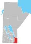
Manitoba. The first chapel was constructed in 1903 and from then on the area became known as Saint-Georges de Chateauguay parish. The first church built in what is now known as St. Georges was in 1909. In 2003 a monument was built to commemorate the hundredth anniversary of the founding of the parish.
31:
and home to the municipality's administrative offices. The parish began in 1882 when Father
Joachim Allard left from the Fort Alexander Indian reserve to live on the Winnipeg River. He invited residents of Chateauguay Quebec to join him so that they could create a French-Canadian parish in the middle
589:
262:
570:
196:
476:
490:
128:
471:
333:
229:
209:
466:
594:
252:
234:
224:
563:
204:
28:
219:
409:
214:
556:
267:
257:
121:
414:
379:
137:
244:
156:
544:
106:
394:
374:
40:
444:
424:
161:
114:
8:
399:
369:
36:
359:
429:
419:
349:
434:
389:
354:
285:
450:
384:
540:
439:
364:
307:
291:
277:
24:
583:
505:
492:
315:
299:
85:
171:
528:
60:
536:
141:
20:
186:
136:
590:
Unincorporated communities in
Eastman Region, Manitoba
581:
564:
122:
86:"Saint Georges CBC Vision Development Report"
571:
557:
129:
115:
91:. Saint Georges Development Corporation
582:
110:
523:
13:
14:
606:
527:
170:
29:Rural Municipality of Alexander
78:
53:
1:
46:
35:The community is accessed by
543:. You can help Knowledge by
477:2015 municipal amalgamations
472:Census divisions of Manitoba
7:
10:
611:
522:
467:Municipalities in Manitoba
343:Unincorporated communities
334:Unorganized Division No. 1
180:Local government districts
461:
342:
326:
276:
243:
195:
179:
168:
149:
595:Manitoba geography stubs
61:"Saint-Georges Manitoba"
27:. It is located in the
19:is a small community in
39:, which is part of the
539:location article is a
65:Saint-Georges Manitoba
506:50.53944°N 96.14889°W
253:Animakee Wa Zhing 37
197:Rural municipalities
162:Powerview–Pine Falls
511:50.53944; -96.14889
502: /
410:Seven Sisters Falls
263:Iskatewizaagegan 39
37:Manitoba Highway 11
144:(Eastern Manitoba)
41:La Vérendrye Trail
552:
551:
485:
484:
327:Unorganized areas
602:
573:
566:
559:
531:
524:
517:
516:
514:
513:
512:
507:
503:
500:
499:
498:
495:
454:
319:
311:
303:
295:
286:Buffalo Point 36
174:
131:
124:
117:
108:
107:
101:
100:
98:
96:
90:
82:
76:
75:
73:
71:
57:
610:
609:
605:
604:
603:
601:
600:
599:
580:
579:
578:
577:
520:
510:
508:
504:
501:
496:
493:
491:
489:
488:
486:
481:
457:
449:
338:
322:
314:
306:
298:
290:
278:Indian reserves
272:
239:
191:
175:
166:
145:
135:
105:
104:
94:
92:
88:
84:
83:
79:
69:
67:
59:
58:
54:
49:
12:
11:
5:
608:
598:
597:
592:
576:
575:
568:
561:
553:
550:
549:
532:
483:
482:
480:
479:
474:
469:
462:
459:
458:
456:
455:
447:
442:
437:
432:
427:
422:
417:
415:South Junction
412:
407:
402:
397:
392:
387:
382:
380:Hillside Beach
377:
372:
367:
362:
357:
352:
346:
344:
340:
339:
337:
336:
330:
328:
324:
323:
321:
320:
312:
308:Shoal Lake 39A
304:
296:
292:Shoal Lake 37A
288:
282:
280:
274:
273:
271:
270:
265:
260:
255:
249:
247:
241:
240:
238:
237:
232:
230:Victoria Beach
227:
222:
217:
212:
207:
201:
199:
193:
192:
190:
189:
183:
181:
177:
176:
169:
167:
165:
164:
159:
153:
151:
147:
146:
138:Division No. 1
134:
133:
126:
119:
111:
103:
102:
77:
51:
50:
48:
45:
25:Winnipeg River
9:
6:
4:
3:
2:
607:
596:
593:
591:
588:
587:
585:
574:
569:
567:
562:
560:
555:
554:
548:
546:
542:
538:
533:
530:
526:
525:
521:
518:
515:
478:
475:
473:
470:
468:
464:
463:
460:
452:
448:
446:
443:
441:
438:
436:
433:
431:
428:
426:
423:
421:
418:
416:
413:
411:
408:
406:
403:
401:
398:
396:
393:
391:
388:
386:
383:
381:
378:
376:
373:
371:
368:
366:
363:
361:
358:
356:
353:
351:
348:
347:
345:
341:
335:
332:
331:
329:
325:
317:
316:Shoal Lake 40
313:
309:
305:
301:
300:Shoal Lake 39
297:
293:
289:
287:
284:
283:
281:
279:
275:
269:
268:Shoal Lake 40
266:
264:
261:
259:
258:Buffalo Point
256:
254:
251:
250:
248:
246:
245:First Nations
242:
236:
233:
231:
228:
226:
223:
221:
218:
216:
213:
211:
210:Lac du Bonnet
208:
206:
203:
202:
200:
198:
194:
188:
185:
184:
182:
178:
173:
163:
160:
158:
157:Lac du Bonnet
155:
154:
152:
148:
143:
139:
132:
127:
125:
120:
118:
113:
112:
109:
87:
81:
70:September 11,
66:
62:
56:
52:
44:
42:
38:
33:
30:
26:
22:
18:
545:expanding it
534:
519:
487:
404:
93:. Retrieved
80:
68:. Retrieved
64:
55:
34:
16:
15:
509: /
405:St. Georges
395:River Hills
375:Hadashville
17:St. Georges
584:Categories
497:96°08′56″W
494:50°32′22″N
465:See also:
445:Whitemouth
425:Stuartburn
235:Whitemouth
225:Stuartburn
47:References
400:Ste. Rita
370:Gardenton
205:Alexander
23:, on the
537:Manitoba
360:Caliento
220:Reynolds
142:Manitoba
95:July 12,
21:Manitoba
430:Sundown
420:Sprague
350:Arbakka
453:(part)
435:Vassar
390:Prawda
355:Badger
318:(part)
310:(part)
302:(part)
294:(part)
187:Pinawa
535:This
451:Zhoda
385:Piney
215:Piney
150:Towns
89:(PDF)
541:stub
440:Vita
365:Elma
97:2020
72:2022
586::
140:,
63:.
43:.
572:e
565:t
558:v
547:.
130:e
123:t
116:v
99:.
74:.
Text is available under the Creative Commons Attribution-ShareAlike License. Additional terms may apply.
