50:
137:
165:
42:
129:
While linear scales are used on architectural and engineering drawings, particularly those that are drawn after the subject has been built, many such drawings do not have a linear scale and are marked "Do Not Scale
Drawing" in recognition of the fact that paper size changes with environmental changes
103:
On large scale maps and charts, those covering a small area, and engineering and architectural drawings, the linear scale can be very simple, a line marked at intervals to show the distance on the earth or object which the distance on the scale represents. A person using the map can use a pair of
136:
104:
dividers (or, less precisely, two fingers) to measure a distance by comparing it to the linear scale. The length of the line on the linear scale is equal to the distance represented on the earth multiplied by the map or chart's scale.
115:, so on small scale maps, covering large areas and a wide range of latitudes, the linear scale must show the scale for the range of latitudes covered by the map. One of these is shown below.
122:
whose scale varies substantially with latitude, linear scales are not used on charts with scales smaller than approximately 1/80,000. Mariners generally use the
126:, which, because a nautical mile is approximately equal to a minute of latitude, can be measured against the latitude scale at the sides of the chart.
233:
339:
372:
324:
266:
178:
defined only "bar scale" in its 1962 Glossary, but added a reference to "graphic scale" by its 2002 edition. Dutton used both terms in 1978. The
143:
53:
Linear scale in both feet and metres in the center of an engineering drawing. The drawing was made 130 years after the bridge was built.
174:
179:
193:
uses "scale" to describe a linear scale and avoids confusion by using "natural scale" for the fraction defined at
130:
and only dimensions that are specifically shown on the drawing can be used reliably in precise manufacturing.
242:
348:
393:
The cited book incorporates IHO Chart INT 1 and therefore represents the practice of the members of the
433:
297:
49:
172:
The terms "bar scale", "graphic scale", "graphical scale", "linear scale", and "scale" are all used.
98:
17:
241:(2002 ed.). Washington: National Imagery and Mapping Agency. pp. 34–35. Archived from
35:
94:
428:
8:
206:
119:
90:
366:
318:
260:
150:, showing, graphically, the change of scale with latitude. Each unit on the map at the
386:
30:
This article is about the graphical representation. For a map mathematical scale, see
211:
187:
164:
45:
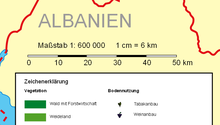
A linear scale showing that one centimetre on the map corresponds to six kilometres
438:
347:(2002 ed.). Washington: National Imagery and Mapping Agency. Archived from
168:
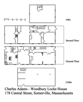
An architectural drawing with a simple linear scale showing feet and half feet.
108:
86:
422:
123:
194:
78:
31:
154:
represents the same distance on the earth as 5.9 units at 80° latitude.
41:
147:
112:
287:(13th ed.). Annapolis: Naval Institute Press. pp. 52–3.
151:
406:
298:
Do a web search on "Do not scale drawing" to see many examples.
313:(1962 ed.). Washington: U.S. Navy Hydrographic Office.
214:(useful e.g. when the data covers a large range of values)
394:
82:
118:
Since most nautical charts are constructed using the
411:. Taunton: The Hydrographer of the Navy. p. 33.
391:. Jointly by NOAA and Department of Commerce, USA.
338:Bowditch, Nathaniel, LLD; et al. "Glossary".
309:Bowditch, Nathaniel, LLD; et al. "Glossary".
420:
388:Chart No. 1, Chart Number, Title, Marginal Notes
407:Lt. Cmdr. C.J. de C. Scott, R.N., ed. (1973).
27:Graphical representation of the scale of a map
371:: CS1 maint: multiple names: authors list (
323:: CS1 maint: multiple names: authors list (
265:: CS1 maint: multiple names: authors list (
225:
331:
302:
278:
276:
163:
48:
40:
282:
180:International Hydrographic Organization
14:
421:
232:Bowditch, Nathaniel, LLD; et al.
273:
77:, is a means of visually showing the
337:
308:
231:
291:
97:. A scale bar is common element of
24:
379:
285:Dutton's Navigation & Piloting
25:
450:
400:
397:, most of the seafaring nations.
341:The American Practical Navigator
311:The American Practical Navigator
235:The American Practical Navigator
135:
159:
186:uses only "linear scale". The
13:
1:
218:
7:
283:Maloney, Elbert S. (1978).
200:
10:
455:
29:
146:The scale from a large
409:The Mariner's Handbook
169:
54:
46:
34:. For other uses, see
167:
95:architectural drawing
52:
44:
111:, scale varies with
188:British Admiralty's
120:Mercator projection
91:engineering drawing
191:Mariner's Handbook
170:
55:
47:
434:Technical drawing
212:Logarithmic scale
16:(Redirected from
446:
413:
412:
404:
398:
392:
383:
377:
376:
370:
362:
360:
359:
353:
346:
335:
329:
328:
322:
314:
306:
300:
295:
289:
288:
280:
271:
270:
264:
256:
254:
253:
247:
240:
229:
207:Engineer's scale
139:
61:, also called a
21:
454:
453:
449:
448:
447:
445:
444:
443:
419:
418:
417:
416:
405:
401:
385:
384:
380:
364:
363:
357:
355:
351:
344:
336:
332:
316:
315:
307:
303:
296:
292:
281:
274:
258:
257:
251:
249:
245:
238:
230:
226:
221:
203:
162:
157:
156:
155:
145:
140:
75:graphical scale
39:
28:
23:
22:
15:
12:
11:
5:
452:
442:
441:
436:
431:
415:
414:
399:
378:
330:
301:
290:
272:
223:
222:
220:
217:
216:
215:
209:
202:
199:
161:
158:
142:
141:
134:
133:
132:
87:nautical chart
26:
9:
6:
4:
3:
2:
451:
440:
437:
435:
432:
430:
427:
426:
424:
410:
403:
396:
390:
389:
382:
374:
368:
354:on 2017-05-17
350:
343:
342:
334:
326:
320:
312:
305:
299:
294:
286:
279:
277:
268:
262:
248:on 2012-03-15
244:
237:
236:
228:
224:
213:
210:
208:
205:
204:
198:
196:
192:
189:
185:
181:
177:
176:
166:
153:
149:
144:
138:
131:
127:
125:
124:nautical mile
121:
116:
114:
110:
105:
101:
100:
96:
92:
88:
84:
80:
76:
72:
71:graphic scale
68:
64:
60:
51:
43:
37:
33:
19:
408:
402:
387:
381:
356:. Retrieved
349:the original
340:
333:
310:
304:
293:
284:
250:. Retrieved
243:the original
234:
227:
190:
183:
173:
171:
160:Nomenclature
128:
117:
106:
102:
99:map layouts.
74:
70:
66:
62:
59:linear scale
58:
56:
429:Cartography
195:scale (map)
184:Chart No. 1
109:projections
32:Scale (map)
423:Categories
358:2010-11-16
252:2010-11-16
219:References
367:cite book
319:cite book
261:cite book
148:world map
67:scale bar
63:bar scale
18:Scale bar
201:See also
175:Bowditch
113:latitude
107:In most
152:equator
439:Scales
352:(PDF)
345:(PDF)
246:(PDF)
239:(PDF)
93:, or
81:of a
79:scale
73:, or
36:Scale
373:link
325:link
267:link
395:IHO
182:'s
83:map
425::
369:}}
365:{{
321:}}
317:{{
275:^
263:}}
259:{{
197:.
89:,
85:,
69:,
65:,
57:A
375:)
361:.
327:)
269:)
255:.
38:.
20:)
Text is available under the Creative Commons Attribution-ShareAlike License. Additional terms may apply.


