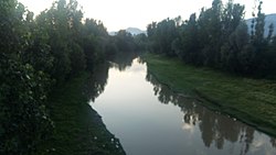
205:(Urdu: پہرو) is a right tributary of Jhelum River that flows through the Kupwara and Baramulla district of Kashmir region. Pohru river is formed by joining of Khamil Nallah and Lolab Nallah in the Kupwara town. Khamil Nallah originates from Shamashabri mountains in the Bangus valley and is joined by Budnamal Nallah at Chowkibal. Lolab Nallah is formed by confluence of several streams like Khurhama stream, Kalarose stream, Gund Machar stream etc. Mawer River is the main tributary of Pohru river, it originates from Kazinag Mountains and joins Pohru river at Ujroo Village of Langate tehsil. Pohru river passes through many villages where it finally enters into the jehum river near Doabgah sopore town Baramullah district Pohru River is one of the tributaries of the river Jhelum.
29:
313:
314:
https://environmentclearance.nic.in/DownloadPfdFile.aspx?FileName=WmO5ltdE7L5+OeFPOYlgj042Ljhg7c7zXQN/IT7i9rYJ3glJcjeEOnpm20pr5evJ2jrsPDIJrD2Xts2hIeLnNVdUExiK4Ngh5FeypmNPF5/ktskmd5m2rvBDsU3cFPqv&FilePath=93ZZBm8LWEXfg+HAlQix2fE2t8z/pgnoBhDlYdZCxzUlDadBGu7t8v4JoQvNU6UBy2No3WLWEFZIoQLhoHUNLWmdYQVwS3XLlkV1Hyte9J8+0UKM1jia0TaGw1mzgPVb
267:
354:
107:
299:
373:
52:
289:
347:
378:
340:
222:
8:
72:
328:
295:
324:
62:
367:
246:
122:
109:
93:
88:
76:
28:
265:
247:"Pohru River, Jammu And Kashmir, India - GeoYP.com"
365:
323:This article related to a river in India is a
348:
355:
341:
291:Systematic Geography of Jammu and Kashmir
366:
318:
287:
13:
14:
390:
27:
281:
259:
239:
215:
101: • coordinates
1:
208:
83:Physical characteristics
327:. You can help Knowledge by
266:Central Ground Water Board.
7:
374:Rivers of Jammu and Kashmir
10:
395:
317:
268:"District Profile Kupwara"
168: • maximum
158: • average
148: • minimum
189:
181:
176:
166:
156:
146:
138:
99:
87:
82:
68:
58:
48:
40:
35:
26:
21:
191: • left
288:Qazi, S. A. (2005).
177:Basin features
123:34.2656°N 74.4175°E
119: /
294:. APH Publishing.
379:India river stubs
336:
335:
301:978-81-7648-786-3
199:
198:
53:Jammu and Kashmir
386:
357:
350:
343:
319:
306:
305:
285:
279:
278:
276:
274:
263:
257:
256:
254:
253:
243:
237:
236:
234:
233:
219:
192:
169:
159:
149:
134:
133:
131:
130:
129:
128:34.2656; 74.4175
124:
120:
117:
116:
115:
112:
31:
19:
18:
394:
393:
389:
388:
387:
385:
384:
383:
364:
363:
362:
361:
310:
309:
302:
286:
282:
272:
270:
264:
260:
251:
249:
245:
244:
240:
231:
229:
221:
220:
216:
211:
190:
167:
157:
147:
127:
125:
121:
118:
113:
110:
108:
106:
105:
102:
49:Union Territory
17:
12:
11:
5:
392:
382:
381:
376:
360:
359:
352:
345:
337:
334:
333:
308:
307:
300:
280:
258:
238:
213:
212:
210:
207:
197:
196:
193:
187:
186:
183:
179:
178:
174:
173:
170:
164:
163:
160:
154:
153:
150:
144:
143:
140:
136:
135:
103:
100:
97:
96:
91:
85:
84:
80:
79:
70:
66:
65:
63:Kashmir Valley
60:
56:
55:
50:
46:
45:
42:
38:
37:
33:
32:
24:
23:
16:River in India
15:
9:
6:
4:
3:
2:
391:
380:
377:
375:
372:
371:
369:
358:
353:
351:
346:
344:
339:
338:
332:
330:
326:
321:
320:
316:
315:
303:
297:
293:
292:
284:
269:
262:
248:
242:
228:
224:
223:"Google Maps"
218:
214:
206:
204:
194:
188:
184:
180:
175:
171:
165:
161:
155:
151:
145:
141:
137:
132:
104:
98:
95:
92:
90:
86:
81:
78:
74:
71:
67:
64:
61:
57:
54:
51:
47:
43:
39:
34:
30:
25:
20:
329:expanding it
322:
311:
290:
283:
271:. Retrieved
261:
250:. Retrieved
241:
230:. Retrieved
226:
217:
202:
200:
94:Jhelum River
227:Google Maps
203:Pohru River
195:Mawer river
182:Tributaries
126: /
22:Pohru River
368:Categories
252:2021-05-09
232:2024-02-12
209:References
114:74°25′03″E
111:34°15′56″N
73:Baramulla
69:District
36:Location
77:Kupwara
41:Country
298:
273:10 May
185:
142:
59:Region
172:9feet
162:5feet
152:2feet
139:Depth
89:Mouth
44:India
325:stub
296:ISBN
275:2021
201:The
370::
312:5.
225:.
75:,
356:e
349:t
342:v
331:.
304:.
277:.
255:.
235:.
Text is available under the Creative Commons Attribution-ShareAlike License. Additional terms may apply.
