56:
40:
205:
847:
63:
518:
348:(PiP) program. Machalilla National Park opened an on-site center for educating visitors about the ecology of the park and conservation issues. The park also hired locals to serve as guards, increasing local awareness of the issues impacting the park. Machalilla's partner organization,
800:
774:
795:
753:
686:
779:
743:
676:
696:
738:
309:(kapok) trees and the algaroba tree. Most of the tropical scrub desert and forest of western Ecuador, once 25 percent but now only one percent, can be found in the park.
816:
769:
349:
556:
333:
901:
437:
362:
received its name from the archaeological excavations in the area. This culture may go back to as early as 1800 BCE, and is known for its ceramics.
345:
249:
271:, two species of monkeys and birds of more than 270 species. Many of the large mammals in Machalilla National Park are regionally and locally
110:
891:
55:
522:
549:
415:
896:
640:
252:, small islands and two larger islands, Salango and Isla de la Plata, the latter named for a legendary hoard of silver left by
691:
681:
542:
244:
Established in 1979, Machalilla
National Park near Puerto Lopéz rests along the Pacific coast. It incorporates beaches,
876:
614:
565:
291:
in
Ecuador also come from the coastland of Ecuador. The ocean regions of the park also provide a breeding ground for
881:
706:
455:
671:
886:
722:
25:
701:
666:
456:"La avifauna de la isla de La Plata, Parque Nacional Machalilla, Ecuador, con notas sobre nuevos registros"
434:
661:
480:"First documented record of the Belted Kingfisher Megaceryle alcyon (Linnaeus, 1758) in mainland Ecuador"
832:
589:
871:
748:
594:
604:
353:
619:
584:
579:
329:
624:
609:
8:
412:
359:
272:
230:
87:
463:
384:
288:
280:
264:
238:
163:
498:
493:
219:
39:
441:
419:
305:
284:
352:, has also worked with local communities to provide training on environmentally
234:
851:
312:
Machalilla
National Park has been threatened by a number of factors, including
292:
208:
865:
534:
337:
313:
253:
125:
112:
29:
300:
245:
479:
645:
204:
341:
268:
321:
379:
325:
317:
296:
276:
260:
227:
82:
531:
Tourism website detailing activities in
Machalilla National Park
517:
528:
484:
471:
344:
began contributing funds for conservation as part of the
259:
In 1990 the park was named an internationally important
241:, a small fishing village in the vicinity of the park.
44:
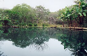
Sulfur lagoon, Aguablanca, Machalilla
National Park
334:United States Agency for International Development
863:
477:
453:
62:
564:
550:
336:and a group of partner organizations across
557:
543:
497:
380:"Zona Marina Parque Nacional Machalilla"
203:
407:
405:
403:
275:. Machalilla National Park is the only
902:Tourist attractions in Manabí Province
864:
174:Zona Marina Parque Nacional Machalilla
538:
430:
428:
413:Machalilla National Park and Vicinity
422:. May 1998. Accessed August 2, 2007.
400:
892:Protected areas established in 1979
478:Cisneros-Heredia, Diego F. (2016).
454:Cisneros-Heredia, Diego F. (2005).
13:
425:
14:
913:
510:
324:and the ecological impact of the
845:
516:
287:. The only known records of the
61:
54:
38:
435:Dry Tropical Forests of Ecuador
499:10.7287/peerj.preprints.1896v1
447:
372:
1:
365:
897:Geography of Manabí Province
467:(24). Neotropical Bird Club.
7:
789:National Recreational Parks
10:
918:
566:Protected areas of Ecuador
224:Parque Nacional Machalilla
877:National parks of Ecuador
841:
825:
809:
788:
762:
731:
715:
654:
633:
572:
444:. Accessed August 2, 2007
387:Sites Information Service
198:
194:
186:
178:
170:
161:
157:
149:
141:
104:
96:
75:
49:
37:
23:
18:
523:Machalilla National Park
237:and the rural parish of
216:Machalilla National Park
19:Machalilla National Park
882:Ramsar sites in Ecuador
356:and fishing practices.
226:) is a preserve in the
775:Muisne River Mangroves
330:The Nature Conservancy
295:. Vegetation includes
223:
212:
716:Geobotanical Reserves
207:
529:VisitPuertoLopez.com
525:at Wikimedia Commons
267:. Wildlife includes
126:1.56250°S 80.83000°W
887:Puerto López Canton
655:Ecological Reserves
634:Biological Reserves
615:Sumaco Napo-Galeras
211:off the park coasts
131:-1.56250; -80.83000
122: /
852:Ecuador portal
780:Santa Clara Island
492:(e1896v1). PeerJ.
440:2009-01-24 at the
418:2009-02-26 at the
360:Machalilla culture
318:commercial fishing
213:
187:Reference no.
859:
858:
732:Wildlife Reserves
692:Cotacachi Cayapas
682:Churute Mangroves
521:Media related to
289:Belted Kingfisher
281:Galapagos Islands
265:Ramsar Convention
254:Sir Francis Drake
202:
201:
97:Nearest city
909:
872:IUCN Category II
850:
849:
848:
810:Binational Parks
763:Wildlife Refuges
559:
552:
545:
536:
535:
520:
504:
503:
501:
475:
469:
468:
460:
451:
445:
432:
423:
409:
398:
397:
395:
393:
376:
350:Fundación Natura
326:tourist industry
301:palo santo trees
182:7 September 1990
137:
136:
134:
133:
132:
127:
123:
120:
119:
118:
115:
65:
64:
58:
42:
16:
15:
917:
916:
912:
911:
910:
908:
907:
906:
862:
861:
860:
855:
846:
844:
837:
826:Marine Reserves
821:
805:
784:
758:
727:
711:
650:
629:
568:
563:
513:
508:
507:
485:PeerJ Preprints
476:
472:
458:
452:
448:
442:Wayback Machine
433:
426:
420:Wayback Machine
411:Smith, Julian.
410:
401:
391:
389:
378:
377:
373:
368:
306:Ceiba pentandra
293:humpback whales
285:waved albatross
279:outside of the
231:Manabí Province
166:
130:
128:
124:
121:
116:
113:
111:
109:
108:
92:
88:Manabí Province
71:
70:
69:
68:
67:
66:
45:
33:
12:
11:
5:
915:
905:
904:
899:
894:
889:
884:
879:
874:
857:
856:
842:
839:
838:
836:
835:
829:
827:
823:
822:
820:
819:
813:
811:
807:
806:
804:
803:
798:
792:
790:
786:
785:
783:
782:
777:
772:
766:
764:
760:
759:
757:
756:
751:
746:
744:Corazón Island
741:
735:
733:
729:
728:
726:
725:
719:
717:
713:
712:
710:
709:
704:
699:
694:
689:
684:
679:
677:Cayapas Mataje
674:
669:
664:
658:
656:
652:
651:
649:
648:
643:
637:
635:
631:
630:
628:
627:
622:
617:
612:
607:
602:
597:
592:
587:
582:
576:
574:
573:National Parks
570:
569:
562:
561:
554:
547:
539:
533:
532:
526:
512:
511:External links
509:
506:
505:
470:
446:
424:
399:
370:
369:
367:
364:
346:Parks in Peril
297:opuntia cactus
209:Humpback whale
200:
199:
196:
195:
192:
191:
188:
184:
183:
180:
176:
175:
172:
168:
167:
164:Ramsar Wetland
162:
159:
158:
155:
154:
151:
147:
146:
143:
139:
138:
106:
102:
101:
98:
94:
93:
91:
90:
85:
79:
77:
73:
72:
60:
59:
53:
52:
51:
50:
47:
46:
43:
35:
34:
24:
21:
20:
9:
6:
4:
3:
2:
914:
903:
900:
898:
895:
893:
890:
888:
885:
883:
880:
878:
875:
873:
870:
869:
867:
854:
853:
840:
834:
831:
830:
828:
824:
818:
815:
814:
812:
808:
802:
799:
797:
794:
793:
791:
787:
781:
778:
776:
773:
771:
768:
767:
765:
761:
755:
752:
750:
747:
745:
742:
740:
737:
736:
734:
730:
724:
721:
720:
718:
714:
708:
707:Mache Chindul
705:
703:
700:
698:
695:
693:
690:
688:
687:Cofán Bermejo
685:
683:
680:
678:
675:
673:
670:
668:
665:
663:
660:
659:
657:
653:
647:
644:
642:
639:
638:
636:
632:
626:
623:
621:
618:
616:
613:
611:
608:
606:
603:
601:
598:
596:
593:
591:
588:
586:
583:
581:
578:
577:
575:
571:
567:
560:
555:
553:
548:
546:
541:
540:
537:
530:
527:
524:
519:
515:
514:
500:
495:
491:
487:
486:
481:
474:
466:
465:
457:
450:
443:
439:
436:
431:
429:
421:
417:
414:
408:
406:
404:
388:
386:
381:
375:
371:
363:
361:
357:
355:
351:
347:
343:
339:
338:Latin America
335:
331:
327:
323:
319:
315:
314:deforestation
310:
308:
307:
302:
298:
294:
290:
286:
282:
278:
274:
270:
266:
262:
257:
255:
251:
247:
242:
240:
236:
232:
229:
225:
221:
217:
210:
206:
197:
193:
189:
185:
181:
177:
173:
171:Official name
169:
165:
160:
156:
152:
148:
144:
140:
135:
107:
103:
99:
95:
89:
86:
84:
81:
80:
78:
74:
57:
48:
41:
36:
31:
30:national park
27:
26:IUCN category
22:
17:
843:
672:Cayambe Coca
599:
489:
483:
473:
462:
449:
390:. Retrieved
383:
374:
358:
354:agricultural
311:
304:
258:
243:
235:Puerto López
215:
214:
100:Puerto López
801:Parque Lago
646:Maquipucuna
595:Llanganates
328:. In 1991,
150:Established
129: /
105:Coordinates
866:Categories
796:El Boliche
739:Chimborazo
641:Limoncocha
605:Podocarpus
600:Machalilla
366:References
273:endangered
269:armadillos
263:under the
250:dry forest
246:fog forest
239:Machalilla
228:Ecuadorian
179:Designated
117:80°49′48″W
833:Galápagos
817:El Condor
754:El Salado
723:Pululahua
702:Illinizas
667:Arenillas
590:Galápagos
342:Caribbean
145:750.59 km
114:1°33′45″S
770:Pasochoa
749:Cuyabeno
697:El Ángel
662:Antisana
585:Cotopaxi
438:Archived
416:Archived
392:25 April
340:and the
322:poaching
76:Location
464:Cotinga
277:habitat
261:wetland
220:Spanish
83:Ecuador
625:Yasuni
620:Yacurí
610:Sangay
385:Ramsar
332:, the
580:Cajas
459:(PDF)
233:near
394:2018
153:1979
142:Area
28:II (
494:doi
283:of
256:.
190:503
868::
488:.
482:.
461:.
427:^
402:^
382:.
320:,
316:,
303:,
299:,
248:,
222::
558:e
551:t
544:v
502:.
496::
490:4
396:.
218:(
32:)
Text is available under the Creative Commons Attribution-ShareAlike License. Additional terms may apply.


