45:
181:
29:
301:
310:
52:
292:
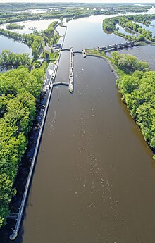
Many types of vessels use the lock which annually passes more than 11 million tons of cargo, including farm products, chemicals and crude materials as the main items shipped. Each year more than 20,000 recreational craft use Lock 3, making it one of the most popular locks on the river. Also, a number
277:. More than 2,000 feet (609.6 m) of earth embankment with a series of upstream spot dikes completes the structure to create Pool 3. The lock chamber is 110 feet (33.5 m) wide by 600 feet (182.9 m) long. The lock and dam is owned and operated by the
384:
391:
691:
696:
273:
796.9. It was constructed and placed in operation July 1938. The site underwent major rehabilitation from 1988 through 1991. The dam is 365 feet (111.3 m) long with 4
716:
711:
354:
424:
444:
377:
414:
400:
726:
721:
359:
419:
449:
108:
44:
741:
282:
746:
681:
329:
324:
349:
184:
756:
751:
286:
369:
706:
701:
625:
75:
87:
83:
364:
Upper
Mississippi River 9-Foot Channel Project, Lock & Dam No. 3, Red Wing, Goodhue County, MN
686:
434:
263:
200:
251:
736:
180:
731:
8:
631:
620:
615:
610:
605:
600:
595:
590:
585:
580:
575:
570:
565:
560:
555:
550:
525:
495:
490:
278:
259:
71:
658:
649:
545:
540:
535:
530:
520:
515:
505:
500:
266:
454:
474:
236:
675:
469:
459:
123:
110:
95:
439:
464:
429:
399:
363:
355:
U.S. Army Corps of
Engineers, St. Paul District: Lock and Dam 3 brochure
274:
270:
91:
79:
300:
28:
366:", 98 photos, 11 data pages, 7 photo caption pages
309:
350:
U.S. Army Corps of
Engineers, St. Paul District Lock and Dam 3
293:
of boats involved with fishing tournament utilize the lock.
255:
692:
Buildings and structures in
Goodhue County, Minnesota
401:
697:
Buildings and structures in Pierce County, Wisconsin
717:Historic American Engineering Record in Wisconsin
712:Historic American Engineering Record in Minnesota
673:
385:
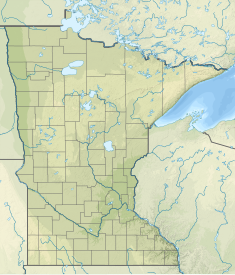
59:Location of Lock and Dam No. 3 in Minnesota
727:Transport infrastructure completed in 1938
722:United States Army Corps of Engineers dams
392:
378:
51:
27:
210:365 feet (111.3 m) (movable portion)
299:
241:45,170 sq mi (117,000 km)
674:
373:
325:Public Works Administration dams list
283:United States Army Corps of Engineers
231:1,110,000 acre⋅ft (1.37 km)
360:Historic American Engineering Record
33:Mississippi River Lock and Dam No. 3
13:
14:
768:
343:
308:
179:
50:
43:
16:Dam in Wisconsin, United States.
330:Prairie Island Indian Community
295:
1:
742:Dams on the Mississippi River
335:
628:(Melvin Price Locks and Dam)
185:U.S. Army Corps of Engineers
7:
747:Mississippi Valley Division
318:
287:Mississippi Valley Division
163:; 86 years ago
145:; 89 years ago
10:
773:
641:
496:Lower Saint Anthony Falls
491:Upper Saint Anthony Falls
483:
407:
235:
227:
219:
214:
206:
196:
191:
175:
157:
139:
102:
67:
38:
26:
21:
362:(HAER) No. MN-21, "
682:Mississippi River locks
435:Winnibigoshish Lake Dam
425:Ottertail Power Co. Dam
201:Upper Mississippi River
140:Construction began
304:
634:(Chain of Rocks Lock)
445:Blandin Paper Co. Dam
303:
124:44.61000°N 92.61028°W
415:Stepping Stones Dam
260:Red Wing, Minnesota
237:Catchment area
228:Total capacity
187:, St. Paul District
129:44.61000; -92.61028
120: /
757:Locks of Wisconsin
752:Locks of Minnesota
659:Lock and Dam No. 4
650:Lock and Dam No. 2
305:
248:Lock and Dam No. 3
22:Lock and Dam No. 3
707:Dams in Wisconsin
702:Dams in Minnesota
669:
668:
664:
663:
316:
315:
279:St. Paul District
267:Mississippi River
245:
244:
192:Dam and spillways
158:Opening date
764:
644:
643:
455:Little Falls Dam
394:
387:
380:
371:
370:
312:
296:
183:
171:
169:
164:
153:
151:
146:
135:
134:
132:
131:
130:
125:
121:
118:
117:
116:
113:
54:
53:
47:
31:
19:
18:
772:
771:
767:
766:
765:
763:
762:
761:
672:
671:
670:
665:
657:
648:
637:
479:
475:Coon Rapids Dam
403:
398:
346:
340:
338:
321:
167:
165:
162:
149:
147:
144:
128:
126:
122:
119:
114:
111:
109:
107:
106:
63:
62:
61:
60:
57:
56:
55:
34:
17:
12:
11:
5:
770:
760:
759:
754:
749:
744:
739:
734:
729:
724:
719:
714:
709:
704:
699:
694:
689:
687:Driftless Area
684:
667:
666:
662:
661:
654:
652:
642:
639:
638:
636:
635:
629:
623:
618:
613:
608:
603:
598:
593:
588:
583:
578:
573:
568:
563:
558:
553:
548:
543:
538:
533:
528:
523:
518:
513:
508:
503:
498:
493:
487:
485:
484:Locks and dams
481:
480:
478:
477:
472:
467:
462:
457:
452:
447:
442:
437:
432:
427:
422:
417:
411:
409:
405:
404:
397:
396:
389:
382:
374:
368:
367:
357:
352:
345:
344:External links
342:
337:
334:
333:
332:
327:
320:
317:
314:
313:
306:
243:
242:
239:
233:
232:
229:
225:
224:
221:
217:
216:
212:
211:
208:
204:
203:
198:
194:
193:
189:
188:
177:
173:
172:
159:
155:
154:
141:
137:
136:
104:
100:
99:
76:Goodhue County
69:
65:
64:
58:
49:
48:
42:
41:
40:
39:
36:
35:
32:
24:
23:
15:
9:
6:
4:
3:
2:
769:
758:
755:
753:
750:
748:
745:
743:
740:
738:
735:
733:
730:
728:
725:
723:
720:
718:
715:
713:
710:
708:
705:
703:
700:
698:
695:
693:
690:
688:
685:
683:
680:
679:
677:
660:
655:
653:
651:
646:
645:
640:
633:
630:
627:
624:
622:
619:
617:
614:
612:
609:
607:
604:
602:
599:
597:
594:
592:
589:
587:
584:
582:
579:
577:
574:
572:
569:
567:
564:
562:
559:
557:
554:
552:
549:
547:
544:
542:
539:
537:
534:
532:
529:
527:
524:
522:
519:
517:
514:
512:
509:
507:
504:
502:
499:
497:
494:
492:
489:
488:
486:
482:
476:
473:
471:
470:St. Cloud Dam
468:
466:
463:
461:
460:Blanchard Dam
458:
456:
453:
451:
448:
446:
443:
441:
438:
436:
433:
431:
428:
426:
423:
421:
418:
416:
413:
412:
410:
406:
402:
395:
390:
388:
383:
381:
376:
375:
372:
365:
361:
358:
356:
353:
351:
348:
347:
341:
331:
328:
326:
323:
322:
311:
307:
302:
298:
297:
294:
290:
288:
284:
280:
276:
272:
268:
265:
261:
258:located near
257:
253:
249:
240:
238:
234:
230:
226:
222:
218:
213:
209:
205:
202:
199:
195:
190:
186:
182:
178:
174:
160:
156:
142:
138:
133:
105:
101:
97:
96:United States
93:
89:
88:Pierce County
85:
84:Diamond Bluff
81:
77:
73:
70:
66:
46:
37:
30:
25:
20:
737:Gravity dams
510:
450:Potlatch Dam
440:Pokegama Dam
339:
291:
275:roller gates
247:
246:
732:Roller dams
656:Downstream:
465:Sartell Dam
430:Knutson Dam
420:Vekin's Dam
176:Operator(s)
127: /
103:Coordinates
676:Categories
336:References
271:river mile
115:92°36′37″W
112:44°36′36″N
647:Upstream:
215:Reservoir
161:July 1938
92:Wisconsin
80:Minnesota
319:See also
197:Impounds
72:Red Wing
68:Location
281:of the
269:around
262:on the
220:Creates
166: (
148: (
223:Pool 3
207:Length
264:Upper
250:is a
408:Dams
254:and
252:lock
168:1938
150:1935
143:1935
256:dam
678::
632:27
626:26
621:25
616:24
611:22
606:21
601:20
596:19
591:18
586:17
581:16
576:15
571:14
566:13
561:12
556:11
551:10
526:5A
289:.
94:,
90:,
86:,
82:/
78:,
74:,
546:9
541:8
536:7
531:6
521:5
516:4
511:3
506:2
501:1
393:e
386:t
379:v
285:-
170:)
152:)
98:.
Text is available under the Creative Commons Attribution-ShareAlike License. Additional terms may apply.


