19:
27:
103:
was established between this point and Port
Deposit in the 1720s and operated until the completion of the bridge from Port Deposit to the Rock Run Mill just upstream of Lapidum in 1818. In 1729, Thomas Cresap established a regular ferry service near Smith's Falls (in the upper Port Deposit area)
152:
By 1900, the sources of
Lapidum's commerce and prosperity were lost to railroad competition. Ice accumulations (referred to locally as "ice gorges") eventually destroyed the warehouses and wharves. The hotel continued as a fishing lodge and men's club until the 1960s, when it was torn down.
74:
for the tracts known as "Eightrapp" (1665), "Faton" (1679) and "Land of
Promise" (1684). As settlers transformed the surrounding land from forest to farmland the area grew in importance as a commercial center. Fields of
136:
hall, a school, and numerous houses, stores and warehouses as well as wharves to serve the trade from goods being brought down the
Susquehanna River or by road from the adjacent countryside to be loaded onto ships.
112:, as far as the jurisdiction extends, was authorized. In the same year, in the jurisdiction south of the river, a petition was submitted for a road from the mill at Rock Run just above Lapidum to
104:
crossing the
Susquehanna to Lapidum; this was referred to as Smith's Ferry or Upper Ferry (there was a lower ferry at the mouth of the Susquehanna River just off the
252:
132:
in 1868. It was constructed of stone, brick and framed with lumber, and included several large porches. Other buildings included a church, a mill, a
296:
239:
194:
244:
209:
157:
291:
223:
History Of Cecil County, Md, And The Early
Settlements Around The Head Of Chesapeake Bay And On The Delaware River
169:
141:
83:
were grown on land near the river, and an important fishing industry also developed, based on the runs of
113:
42:
191:
125:
144:, and from its location as one of the highest deepwater landings for Chesapeake Bay shipping.
8:
18:
50:
198:
26:
105:
285:
267:
254:
129:
109:
54:
71:
38:
46:
133:
88:
80:
140:
Lapidum profited from the financial success of the ferry, the
100:
76:
245:
Susquehanna State Park in World
Database on Protected Areas
116:. This upper ferry came to be known as "Creswell's Ferry."
84:
108:). In 1731, a road from Susquehanna Upper Ferry toward
210:
70:
Lapidum traces its history to the granting of early
240:
Official website of
Maryland Susquehanna State Park
128:building, the Susquehanna Hotel, was built here by
283:
220:
49:, USA, located at the head of navigation of the
30:Lock 9 at Lapidum on the former Tidewater Canal.
25:
17:
225:. Regional Publishing, Baltimore. ISBN.
214:
284:
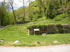
22:Foundation of former hotel in Lapidum.
297:Geography of Harford County, Maryland
203:
187:
185:
13:
158:Susquehanna State Park in Maryland
14:
308:
233:
182:
192:Susquehanna State Park History
170:List of ghost towns in Maryland
147:
142:Susquehanna and Tidewater Canal
119:
94:
65:
156:The land is currently part of
1:
175:
53:on the west bank across from
7:
163:
10:
313:
221:Johnston, George (1972) .
114:Peach Bottom, Pennsylvania
60:
292:Ghost towns in Maryland
31:
23:
268:39.59778°N 76.12889°W
29:
21:
273:39.59778; -76.12889
264: /
197:2007-04-27 at the
32:
24:
51:Susquehanna River
304:
279:
278:
276:
275:
274:
269:
265:
262:
261:
260:
257:
227:
226:
218:
212:
207:
201:
189:
312:
311:
307:
306:
305:
303:
302:
301:
282:
281:
272:
270:
266:
263:
258:
255:
253:
251:
250:
236:
231:
230:
219:
215:
208:
204:
199:Wayback Machine
190:
183:
178:
166:
150:
122:
97:
68:
63:
12:
11:
5:
310:
300:
299:
294:
248:
247:
242:
235:
234:External links
232:
229:
228:
213:
202:
180:
179:
177:
174:
173:
172:
165:
162:
149:
146:
124:A three-story
121:
118:
106:Chesapeake Bay
96:
93:
67:
64:
62:
59:
43:Harford County
9:
6:
4:
3:
2:
309:
298:
295:
293:
290:
289:
287:
280:
277:
246:
243:
241:
238:
237:
224:
217:
211:
206:
200:
196:
193:
188:
186:
181:
171:
168:
167:
161:
159:
154:
145:
143:
138:
135:
131:
127:
117:
115:
111:
107:
102:
92:
90:
86:
82:
78:
73:
58:
56:
52:
48:
44:
40:
36:
28:
20:
16:
249:
222:
216:
205:
155:
151:
148:20th century
139:
130:Conrad Baker
123:
120:19th century
110:Philadelphia
98:
95:18th century
72:land patents
69:
66:17th century
55:Port Deposit
34:
33:
15:
271: /
286:Categories
259:76°07′44″W
256:39°35′52″N
176:References
39:ghost town
126:Victorian
195:Archived
164:See also
47:Maryland
134:Masonic
89:herring
81:tobacco
61:History
35:Lapidum
101:ferry
37:is a
87:and
85:shad
79:and
77:corn
41:in
288::
184:^
160:.
99:A
91:.
57:.
45:,
Text is available under the Creative Commons Attribution-ShareAlike License. Additional terms may apply.

