76:
61:
51:
207:
the immense natural forests of quinine of the region. Its historical antecedents go back approximately to the year 1865 when the quinera company Compañía
Colombia, of the company Herrera and Uribe, agreed the construction of a town in order to commercially administrate the extensive vacant territories given in concession by the government, which were abundant in natural forests of rubber and especially of quinine, medicinal element that at that time was in great demand in the international markets.
92:
491:
542:
206:
In 1925, Uribe ceased to be a municipality, passing again to corregimiento intendencias. However, within the urban area of Uribe as the oldest. Its name corresponds to the surname of
Antonio Uribe, one of the two partners of the latifundist Company Colombia, that with the official permission exploded
203:
The population of Uribe goes back to 1886 elevated to municipality in 1921 that included the metropolitan area of San Juan de Arama according to the Decree No. 940 of 1921.
75:
317:
249:
310:
607:
602:
503:
583:
303:
270:
171:
576:
60:
176:
37:
569:
353:
104:
50:
17:
438:
453:
8:
480:
278:
468:
343:
549:
463:
458:
443:
398:
373:
80:
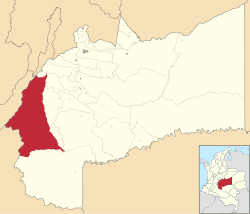
Location of the municipality and town of La Uribe in the Meta
Department of Colombia.
490:
295:
423:
557:
428:
378:
327:
188:
109:
553:
448:
596:
518:
505:
474:
433:
388:
383:
393:
413:
368:
408:
338:
245:
158:
358:
348:
223:
192:
97:
418:
363:
541:
163:
325:
23:Municipality and town in Meta Department, Colombia
594:
577:
311:
246:"Censo Nacional de Población y Vivienda 2018"
584:
570:
318:
304:
595:
299:
124:6,037 km (2,331 sq mi)
536:
238:
216:
13:
187:is a town and municipality in the
14:
619:
603:Municipalities of Meta Department
608:Orinoquía Region geography stubs
540:
489:
90:
74:
59:
49:
263:
1:
210:
556:. You can help Knowledge by
224:"Municipalities of Colombia"
7:
10:
624:
535:
198:
132:835 m (2,740 ft)
15:
487:
334:
170:
157:
149:
141:
136:
128:
120:
115:
103:
85:
73:
45:
35:
28:
166:(Colombia Standard Time)
153:1.4/km (3.7/sq mi)
552:location article is a
18:Uribe (disambiguation)
275:www.uribe-meta.gov.co
519:3.24083°N 74.35361°W
454:San Carlos de Guaroa
150: • Density
16:For other uses, see
515: /
271:"Nuestro Municipio"
550:Department of Meta
524:3.24083; -74.35361
326:Municipalities in
142: • Total
121: • Total
565:
564:
498:
497:
459:San Juan de Arama
354:Castilla la Nueva
182:
181:
615:
586:
579:
572:
544:
537:
530:
529:
527:
526:
525:
520:
516:
513:
512:
511:
508:
493:
424:Puerto Concordia
344:Barranca de Upía
320:
313:
306:
297:
296:
291:
290:
288:
286:
277:. Archived from
267:
261:
260:
258:
256:
242:
236:
235:
233:
231:
220:
96:
94:
93:
78:
63:
53:
26:
25:
623:
622:
618:
617:
616:
614:
613:
612:
593:
592:
591:
590:
533:
523:
521:
517:
514:
509:
506:
504:
502:
501:
499:
494:
485:
330:
328:Meta Department
324:
294:
284:
282:
269:
268:
264:
254:
252:
244:
243:
239:
229:
227:
222:
221:
217:
213:
201:
189:Meta Department
110:Meta Department
91:
89:
81:
69:
68:
67:
66:
57:
56:
41:
31:
24:
21:
12:
11:
5:
621:
611:
610:
605:
589:
588:
581:
574:
566:
563:
562:
545:
496:
495:
488:
486:
484:
483:
478:
471:
466:
461:
456:
451:
446:
441:
436:
431:
426:
421:
416:
411:
406:
401:
396:
391:
386:
381:
376:
371:
366:
361:
356:
351:
346:
341:
335:
332:
331:
323:
322:
315:
308:
300:
293:
292:
281:on 28 May 2015
262:
248:(in Spanish).
237:
214:
212:
209:
200:
197:
180:
179:
174:
168:
167:
161:
155:
154:
151:
147:
146:
143:
139:
138:
134:
133:
130:
126:
125:
122:
118:
117:
113:
112:
107:
101:
100:
87:
83:
82:
79:
71:
70:
64:
58:
54:
48:
47:
46:
43:
42:
36:
33:
32:
29:
22:
9:
6:
4:
3:
2:
620:
609:
606:
604:
601:
600:
598:
587:
582:
580:
575:
573:
568:
567:
561:
559:
555:
551:
546:
543:
539:
538:
534:
531:
528:
492:
482:
481:Vista Hermosa
479:
477:
476:
475:Villavicencio
472:
470:
467:
465:
462:
460:
457:
455:
452:
450:
447:
445:
442:
440:
437:
435:
434:Puerto Lleras
432:
430:
429:Puerto Gaitán
427:
425:
422:
420:
417:
415:
412:
410:
407:
405:
402:
400:
397:
395:
392:
390:
387:
385:
384:Fuente de Oro
382:
380:
377:
375:
372:
370:
367:
365:
362:
360:
357:
355:
352:
350:
347:
345:
342:
340:
337:
336:
333:
329:
321:
316:
314:
309:
307:
302:
301:
298:
280:
276:
272:
266:
251:
247:
241:
225:
219:
215:
208:
204:
196:
194:
190:
186:
178:
175:
173:
169:
165:
162:
160:
156:
152:
148:
144:
140:
135:
131:
127:
123:
119:
114:
111:
108:
106:
102:
99:
88:
84:
77:
72:
62:
52:
44:
39:
34:
27:
19:
558:expanding it
547:
532:
500:
473:
439:Puerto López
403:
283:. Retrieved
279:the original
274:
265:
253:. Retrieved
240:
228:. Retrieved
218:
205:
202:
184:
183:
38:Municipality
522: /
464:San Juanito
444:Puerto Rico
399:La Macarena
374:El Castillo
369:El Calvario
597:Categories
510:74°21′13″W
469:San Martín
226:. statoids
211:References
137:Population
105:Department
507:3°14′27″N
414:Mapiripán
379:El Dorado
159:Time zone
129:Elevation
449:Restrepo
409:Lejanías
404:La Uribe
359:Cubarral
349:Cabuyaro
255:26 April
230:26 April
193:Colombia
185:La Uribe
98:Colombia
40:and town
30:La Uribe
419:Mesetas
389:Granada
364:Cumaral
339:Acacías
199:History
172:Climate
86:Country
394:Guamal
285:22 May
95:
548:This
164:UTC-5
145:8,549
554:stub
287:2022
257:2020
250:DANE
232:2020
116:Area
65:Seal
55:Flag
599::
273:.
195:.
191:,
177:Af
585:e
578:t
571:v
560:.
319:e
312:t
305:v
289:.
259:.
234:.
20:.
Text is available under the Creative Commons Attribution-ShareAlike License. Additional terms may apply.


