33:
49:
510:
488:
56:
378:
The main tributaries of the
Kulunda are the 88 km (55 mi) long Chuman (Чуман), the 78 km (48 mi) long Proslaukha (Прослауха), the 56 km (35 mi) long Cheremshanka (Черемшанка) and the 37 km (23 mi) long Solonovka (Солоновка) from the right, as well as the
117:
323:
350:. The river flows roughly southwestwards through one of the wide ravines of glacial origin that are characteristic of the plateau. As it descends to the
182:
547:
311:
287:. The river is 412 kilometres (256 mi) long and has a catchment area of 12,400 square kilometres (4,800 sq mi).
303:
48:
32:
576:
492:
540:
566:
571:
581:
533:
498:
465:
499:
The syntaxonomy of the meadow vegetation of
Kulunda and Kasmala pine forest strips (Altai Territory)
388:
295:
355:
291:
8:
521:
307:
299:
272:
362:. Near its mouth the river turns westwards. Finally it meets the eastern shore of
335:
517:
470:
411:
359:
440:
560:
351:
197:
184:
132:
119:
460:
428:
363:
168:
509:
163:
347:
339:
319:
315:
280:
103:
64:
367:
379:
94 km (58 mi) long
Yermachikha (Ермачиха) from the left.
306:
districts. There are a number of villages near its banks, such as
487:
343:
284:
84:
473:. - 3rd ed. - M. Soviet Encyclopedia, 1969-1978. (in Russian)
412:"Река Кулунда in the State Water Register of Russia"
354:
there are many lakes in its basin, especially close to
558:
516:This article related to a river in Russia is a
541:
548:
534:
290:The basin of the river is located in the
55:
559:
366:about 5 km (3.1 mi) west of
235:12,400 km (4,800 sq mi)
441:"N-44 Topographic Chart (in Russian)"
406:
404:
257:5.27 m/s (186 cu ft/s)
504:
433:
13:
454:
401:
14:
593:
480:
422:
508:
486:
54:
47:
31:
461:Кулунда (река в Алтайском крае)
346:rivers. The sources are in the
334:The Kulunda river system is an
373:
176: • coordinates
111: • coordinates
1:
394:
91:Physical characteristics
520:. You can help Knowledge by
215: • elevation
150: • elevation
7:
382:
154:ca 200 metres (660 ft)
10:
598:
503:
253: • average
466:Great Soviet Encyclopedia
329:
276:
261:
251:
243:
239:
231:
227:412 km (256 mi)
223:
213:
174:
162:
158:
148:
109:
99:
95:
90:
80:
75:
42:
30:
21:
577:Endorheic basins of Asia
389:List of rivers of Russia
16:River in Siberia, Russia
469:in 30 vols. — Ch. ed.
219:99 metres (325 ft)
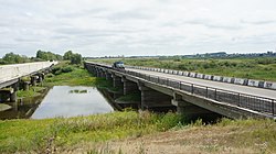
37:Bridge over the Kulunda
198:52.98111°N 79.72278°E
133:53.30056°N 82.13444°E
567:Rivers of Altai Krai
495:at Wikimedia Commons
572:West Siberian Plain
194: /
129: /
582:Russia river stubs
203:52.98111; 79.72278
138:53.30056; 82.13444
63:Mouth location in
529:
528:
491:Media related to
265:
264:
589:
550:
543:
536:
512:
505:
490:
474:
458:
452:
451:
449:
447:
437:
431:
426:
420:
419:
408:
304:Blagoveshchensky
279:) is a river in
278:
254:
209:
208:
206:
205:
204:
199:
195:
192:
191:
190:
187:
151:
144:
143:
141:
140:
139:
134:
130:
127:
126:
125:
122:
112:
58:
57:
51:
35:
19:
18:
597:
596:
592:
591:
590:
588:
587:
586:
557:
556:
555:
554:
493:Kulunda (river)
483:
478:
477:
459:
455:
445:
443:
439:
438:
434:
427:
423:
410:
409:
402:
397:
385:
376:
336:endorheic basin
332:
252:
216:
202:
200:
196:
193:
188:
185:
183:
181:
180:
177:
149:
137:
135:
131:
128:
123:
120:
118:
116:
115:
110:
71:
70:
69:
68:
61:
60:
59:
38:
26:
23:
17:
12:
11:
5:
595:
585:
584:
579:
574:
569:
553:
552:
545:
538:
530:
527:
526:
513:
502:
501:
496:
482:
481:External links
479:
476:
475:
471:A.M. Prokhorov
453:
432:
421:
399:
398:
396:
393:
392:
391:
384:
381:
375:
372:
360:Nizhnechumanka
331:
328:
263:
262:
259:
258:
255:
249:
248:
245:
241:
240:
237:
236:
233:
229:
228:
225:
221:
220:
217:
214:
211:
210:
178:
175:
172:
171:
166:
160:
159:
156:
155:
152:
146:
145:
113:
107:
106:
101:
97:
96:
93:
92:
88:
87:
82:
78:
77:
73:
72:
62:
53:
52:
46:
45:
44:
43:
40:
39:
36:
28:
27:
24:
15:
9:
6:
4:
3:
2:
594:
583:
580:
578:
575:
573:
570:
568:
565:
564:
562:
551:
546:
544:
539:
537:
532:
531:
525:
523:
519:
514:
511:
507:
506:
500:
497:
494:
489:
485:
484:
472:
468:
467:
462:
457:
442:
436:
430:
425:
418:(in Russian).
417:
413:
407:
405:
400:
390:
387:
386:
380:
371:
369:
365:
361:
357:
353:
352:Kulunda Plain
349:
345:
341:
337:
327:
325:
321:
317:
313:
309:
305:
301:
297:
296:Tyumentsevsky
293:
288:
286:
282:
274:
270:
260:
256:
250:
246:
242:
238:
234:
230:
226:
222:
218:
212:
207:
179:
173:
170:
167:
165:
161:
157:
153:
147:
142:
114:
108:
105:
102:
98:
94:
89:
86:
83:
79:
74:
66:
50:
41:
34:
29:
20:
522:expanding it
515:
464:
456:
444:. Retrieved
435:
429:Google Earth
424:
415:
377:
364:Lake Kulunda
338:between the
333:
292:Rebrikhinsky
289:
268:
266:
169:Lake Kulunda
374:Tributaries
201: /
136: /
561:Categories
416:textual.ru
395:References
348:Ob Plateau
320:Proslaukha
316:Kapustinka
281:Altai Krai
232:Basin size
189:79°43′22″E
186:52°58′52″N
124:82°08′04″E
121:53°18′02″N
104:Ob Plateau
65:Altai Krai
368:Shimolino
356:Andronovo
324:Gryaznovo
244:Discharge
383:See also
342:and the
312:Pokrovka
300:Bayevsky
76:Location
67:, Russia
277:Кулунда
273:Russian
269:Kulunda
81:Country
25:Кулунда
22:Kulunda
446:7 July
344:Irtysh
330:Course
308:Bayevo
285:Russia
247:
224:Length
100:Source
85:Russia
164:Mouth
518:stub
448:2022
358:and
322:and
302:and
267:The
326:.
563::
463:;
414:.
403:^
370:.
340:Ob
318:,
314:,
310:,
298:,
294:,
283:,
275::
549:e
542:t
535:v
524:.
450:.
271:(
Text is available under the Creative Commons Attribution-ShareAlike License. Additional terms may apply.

