274:
250:
1109:
262:
29:
41:
237:
for irrigated agriculture are along the
Turkwel and Kerio rivers. The Lotubai and Morulem irrigation schemes are on the Kerio. The main crops are maize and sorghum, which account for 80% of irrigated crops, as well as green grams, cowpeas, bananas, mangoes, oranges and guavas.
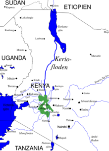
201:. The Elgeyo Escarpment rises to over 1,830 metres (6,000 ft) above the Kerio valley in places. The Kerio continues northward, often through deep and narrow valleys, to enter Lake Turkana in a delta just south of the delta formed by the
225:
lie on the east and west sides of the Kerio River in the upper valley. They are undeveloped, but have abundant birdlife and are known for their scenery. The left bank of a 25 kilometres (16 mi) section of the river is in the
209:
rivers. The Kerio and
Turkwel contribute 98% of the river water flowing into Lake Turkana on Kenyan territory (which makes up only 2% of the total riverine inflow). In their lower courses both these rivers are seasonal.
233:
In 1999 there were allegations that
Fluorspar Mines was dumping toxic waste into the river. These were denied by the responsible Minister for Mineral Exploration. The main locations in
227:
249:
684:
563:
1230:
206:
558:
583:
1150:
885:
1196:
496:
213:
Near its source the Kerio River is fed by two major tributaries flowing down the Elgeyo
Escarpment: Arror River, and Embobut River.
677:
128:
273:
464:
1225:
189:
The Kerio River rises on the north slopes of the Amasya Hills to the west of Lake
Bogoria. It flows northward through the
670:
430:
409:
75:
1143:
1240:
1189:
956:
946:
936:
489:
222:
976:
971:
1235:
1136:
966:
1215:
961:
941:
1182:
951:
261:
1220:
1116:
920:
693:
598:
543:
523:
482:
295:
981:
505:
1058:
420:
399:
623:
454:
441:
986:
8:
783:
255:
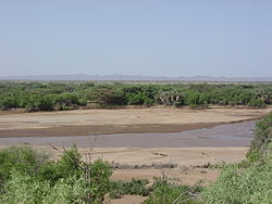
Kerio River during dry season. Riverbed is silty and easily erodes during storm events.
788:
603:
1170:
1124:
773:
460:
426:
405:
198:
742:
234:
844:
707:
573:
528:
1166:
1120:
1088:
895:
793:
778:
752:
727:
717:
643:
593:
553:
300:
166:
1209:
1083:
1048:
1032:
915:
900:
849:
803:
618:
568:
202:
143:
130:
90:
77:
1063:
910:
905:
875:
834:
829:
819:
722:
662:
651:
456:
Livelihood diversification opportunities for pastoralists in
Turkana, Kenya
190:
174:
1053:
859:
854:
839:
824:
798:
757:
613:
608:
588:
578:
533:
194:
111:
1068:
633:
548:
890:
628:
339:
327:
28:
1108:
1078:
1027:
737:
712:
474:
1073:
1012:
1007:
747:
375:
290:
178:
177:. It is one of the longest rivers in Kenya, originating near the
1022:
1017:
1002:
732:
40:
509:
317:
315:
170:
33:
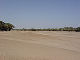
Kerio River flowing after heavy spring rainstorms in the area
351:
312:
397:
345:
333:
398:
Fitzpatrick, Mary; Parkinson, Tom; Ray, Nick (2006).
363:
452:
381:
1207:
1165:This article related to a river in Kenya is a
1190:
1144:
678:
490:
692:
418:
357:
321:
1197:
1183:
1151:
1137:
685:
671:
497:
483:
279:Kerio River flowing after heavy rainstorm.
39:
453:Watson, D.J.; van Binsbergen, J. (2008).
1231:Eastern Province, Kenya geography stubs
1042:Paleontological and archeological sites
221:The Lake Kamnarok National Reserve and
1208:
439:
369:
666:
478:
419:Hughes, R. H.; Hughes, J. S. (1992).
346:Fitzpatrick, Parkinson & Ray 2006
334:Fitzpatrick, Parkinson & Ray 2006
1160:
1103:
442:"Dumping of Toxins into River Keria"
504:
13:
14:
1252:
1107:
382:Watson & van Binsbergen 2008
272:
260:
248:
27:
422:A directory of African wetlands
228:South Turkana National Reserve
122: • coordinates
69: • coordinates
1:
957:Mount Kipipiri Forest Reserve
947:Lake Bogoria National Reserve
937:Kerio Valley National Reserve
459:. ILRI (aka ILCA and ILRAD).
306:
223:Kerio Valley National Reserve
51:Physical characteristics
1169:. You can help Knowledge by
1123:. You can help Knowledge by
977:Mount Longonot National Park
7:
1226:Tributaries of Lake Turkana
967:Lake Naivasha National Park
440:Kalweo (December 7, 1999).
284:
216:
10:
1257:
1159:
1102:
962:Kigio Wildlife Conservancy
942:Lake Baringo National Park
390:
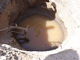
267:Hand dug well in riverbed.
241:
173:. It flows northward into
1041:
995:
972:Hell's Gate National Park
952:Lake Nakuru National Park
929:
868:
812:
766:
700:
642:
516:
184:
120:
110:
106:
67:
59:
55:
50:
38:
26:
21:
1117:Eastern Province (Kenya)
694:Great Rift Valley, Kenya
358:Hughes & Hughes 1992
322:Hughes & Hughes 1992
296:List of rivers of Africa
982:Mount Suswa Conservancy
1119:location article is a
144:2.956584°N 36.151543°E
91:0.528581°N 35.709643°E
1241:Kenya geography stubs
921:Southern Ewaso Ng'iro
767:Hills and escarpments
599:Southern Ewaso Ng'iro
446:Parliamentary Debates
987:Shompole Conservancy
784:Nguruman Escarpment
149:2.956584; 36.151543
140: /
96:0.528581; 35.709643
87: /
1236:Africa river stubs
930:Conservation areas
789:Losiolo Escarpment
524:Athi-Galana-Sabaki
1216:Great Rift Valley
1178:
1177:
1132:
1131:
1097:
1096:
774:Elgeyo Escarpment
660:
659:
466:978-92-9146-210-0
404:. Lonely Planet.
199:Elgeyo Escarpment
159:
158:
1248:
1199:
1192:
1185:
1161:
1153:
1146:
1139:
1111:
1104:
687:
680:
673:
664:
663:
499:
492:
485:
476:
475:
470:
449:
436:
415:
385:
379:
373:
367:
361:
355:
349:
343:
337:
331:
325:
319:
276:
264:
252:
235:Turkana District
155:
154:
152:
151:
150:
145:
141:
138:
137:
136:
133:
102:
101:
99:
98:
97:
92:
88:
85:
84:
83:
80:
70:
43:
31:
19:
18:
1256:
1255:
1251:
1250:
1249:
1247:
1246:
1245:
1221:Rivers of Kenya
1206:
1205:
1204:
1203:
1158:
1157:
1100:
1098:
1093:
1037:
991:
925:
864:
808:
762:
708:Barrier Volcano
696:
691:
661:
656:
638:
512:
503:
473:
467:
433:
412:
393:
388:
380:
376:
372:, p. 2754.
368:
364:
356:
352:
344:
340:
332:
328:
320:
313:
309:
287:
280:
277:
268:
265:
256:
253:
244:
219:
187:
148:
146:
142:
139:
134:
131:
129:
127:
126:
123:
95:
93:
89:
86:
81:
78:
76:
74:
73:
68:
46:
34:
17:
12:
11:
5:
1254:
1244:
1243:
1238:
1233:
1228:
1223:
1218:
1202:
1201:
1194:
1187:
1179:
1176:
1175:
1156:
1155:
1148:
1141:
1133:
1130:
1129:
1112:
1095:
1094:
1092:
1091:
1089:Rusinga Island
1086:
1081:
1076:
1071:
1066:
1061:
1056:
1051:
1045:
1043:
1039:
1038:
1036:
1035:
1030:
1025:
1020:
1015:
1010:
1005:
999:
997:
993:
992:
990:
989:
984:
979:
974:
969:
964:
959:
954:
949:
944:
939:
933:
931:
927:
926:
924:
923:
918:
913:
908:
903:
898:
893:
888:
883:
878:
872:
870:
866:
865:
863:
862:
857:
852:
847:
842:
837:
832:
827:
822:
816:
814:
810:
809:
807:
806:
801:
796:
794:Aberdare Range
791:
786:
781:
779:Mau Escarpment
776:
770:
768:
764:
763:
761:
760:
755:
750:
745:
740:
735:
730:
725:
720:
718:Emuruangogolak
715:
710:
704:
702:
698:
697:
690:
689:
682:
675:
667:
658:
657:
655:
654:
648:
646:
644:Ilemi Triangle
640:
639:
637:
636:
631:
626:
621:
616:
611:
606:
601:
596:
591:
586:
581:
576:
571:
566:
561:
556:
551:
546:
541:
536:
531:
526:
520:
518:
514:
513:
502:
501:
494:
487:
479:
472:
471:
465:
450:
437:
431:
416:
410:
394:
392:
389:
387:
386:
374:
362:
360:, p. 193.
350:
348:, p. 410.
338:
336:, p. 430.
326:
324:, p. 192.
310:
308:
305:
304:
303:
301:Turkana people
298:
293:
286:
283:
282:
281:
278:
271:
269:
266:
259:
257:
254:
247:
243:
240:
218:
215:
186:
183:
167:Turkana County
165:is a river in
157:
156:
124:
121:
118:
117:
114:
108:
107:
104:
103:
71:
65:
64:
61:
57:
56:
53:
52:
48:
47:
44:
36:
35:
32:
24:
23:
15:
9:
6:
4:
3:
2:
1253:
1242:
1239:
1237:
1234:
1232:
1229:
1227:
1224:
1222:
1219:
1217:
1214:
1213:
1211:
1200:
1195:
1193:
1188:
1186:
1181:
1180:
1174:
1172:
1168:
1163:
1162:
1154:
1149:
1147:
1142:
1140:
1135:
1134:
1128:
1126:
1122:
1118:
1113:
1110:
1106:
1105:
1101:
1090:
1087:
1085:
1084:Olduvai Gorge
1082:
1080:
1077:
1075:
1072:
1070:
1067:
1065:
1062:
1060:
1057:
1055:
1052:
1050:
1049:Afar Triangle
1047:
1046:
1044:
1040:
1034:
1031:
1029:
1026:
1024:
1021:
1019:
1016:
1014:
1011:
1009:
1006:
1004:
1001:
1000:
998:
996:Urban centres
994:
988:
985:
983:
980:
978:
975:
973:
970:
968:
965:
963:
960:
958:
955:
953:
950:
948:
945:
943:
940:
938:
935:
934:
932:
928:
922:
919:
917:
914:
912:
909:
907:
904:
902:
899:
897:
894:
892:
889:
887:
884:
882:
879:
877:
874:
873:
871:
867:
861:
858:
856:
853:
851:
848:
846:
843:
841:
838:
836:
833:
831:
828:
826:
823:
821:
818:
817:
815:
811:
805:
804:Loriu Plateau
802:
800:
797:
795:
792:
790:
787:
785:
782:
780:
777:
775:
772:
771:
769:
765:
759:
756:
754:
751:
749:
746:
744:
741:
739:
736:
734:
731:
729:
726:
724:
721:
719:
716:
714:
711:
709:
706:
705:
703:
699:
695:
688:
683:
681:
676:
674:
669:
668:
665:
653:
650:
649:
647:
645:
641:
635:
632:
630:
627:
625:
622:
620:
617:
615:
612:
610:
607:
605:
602:
600:
597:
595:
592:
590:
587:
585:
582:
580:
577:
575:
572:
570:
567:
565:
562:
560:
557:
555:
552:
550:
547:
545:
542:
540:
537:
535:
532:
530:
527:
525:
522:
521:
519:
515:
511:
507:
500:
495:
493:
488:
486:
481:
480:
477:
468:
462:
458:
457:
451:
447:
443:
438:
434:
432:2-88032-949-3
428:
424:
423:
417:
413:
411:1-74104-286-0
407:
403:
402:
396:
395:
384:, p. 16.
383:
378:
371:
366:
359:
354:
347:
342:
335:
330:
323:
318:
316:
311:
302:
299:
297:
294:
292:
289:
288:
275:
270:
263:
258:
251:
246:
245:
239:
236:
231:
229:
224:
214:
211:
208:
204:
200:
196:
192:
182:
180:
176:
172:
168:
164:
153:
125:
119:
115:
113:
109:
105:
100:
72:
66:
62:
58:
54:
49:
42:
37:
30:
25:
20:
1171:expanding it
1164:
1125:expanding it
1114:
1099:
880:
538:
529:Ewaso Ng'iro
455:
445:
421:
400:
377:
365:
353:
341:
329:
232:
220:
212:
191:Kerio Valley
188:
175:Lake Turkana
162:
160:
45:River course
1054:Aiyangiyang
799:Ngong Hills
758:Mount Suswa
629:Voi (Goshi)
401:East África
370:Kalweo 1999
195:Tugen Hills
163:Kerio River
147: /
94: /
22:Kerio River
1210:Categories
1069:Koobi Fora
845:Elmenteita
604:Tana River
307:References
135:36°09′06″E
82:35°42′35″E
891:Ol Arabel
701:Volcanoes
574:Naro Moru
564:Mononoase
132:2°57′24″N
79:0°31′43″N
1079:Lothagam
1059:Amboseli
1028:Naivasha
896:Perkerra
850:Naivasha
753:Longonot
738:Menengai
713:Namarunu
594:Perkerra
554:Mbagathi
425:. IUCN.
285:See also
217:Land use
207:Lokichar
193:between
1074:Laetoli
1013:Marigat
1008:Kinyang
916:Turasha
901:Waseges
835:Bogoria
830:Baringo
820:Turkana
748:Olkaria
619:Turkwel
569:Nairobi
559:Mogonga
391:Sources
291:Biretwo
242:Gallery
203:Turkwel
179:equator
1033:Magadi
1023:Gilgil
1018:Nakuru
1003:Kapedo
911:Malewa
906:Gilgil
876:Suguta
869:Rivers
860:Natron
855:Magadi
840:Nakuru
825:Logipi
743:Eburru
733:Korosi
723:Silali
652:Kangen
584:Nyando
506:Rivers
463:
429:
408:
185:Course
116:
63:
60:Source
1115:This
1064:Karsa
881:Kerio
813:Lakes
614:Tsavo
609:Thika
589:Nzoia
579:Njoro
539:Kerio
534:Gucha
517:Kenya
510:Kenya
171:Kenya
112:Mouth
16:River
1167:stub
1121:stub
886:Molo
728:Paka
634:Yala
624:Umba
549:Mara
544:Lumi
461:ISBN
427:ISBN
406:ISBN
205:and
197:and
161:The
508:of
1212::
444:.
314:^
230:.
181:.
169:,
1198:e
1191:t
1184:v
1173:.
1152:e
1145:t
1138:v
1127:.
686:e
679:t
672:v
498:e
491:t
484:v
469:.
448:.
435:.
414:.
Text is available under the Creative Commons Attribution-ShareAlike License. Additional terms may apply.


