369:
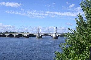
span of 209 feet (64 m) and a rise of 29.71 feet (9.06 m); the ribs of the other spans vary from 176.5 to 121 feet (53.8 to 36.9 m) in length, with rises from 29.2 to 19.1 feet (8.9 to 5.8 m). The three interior ribs in each span are grouped together near the center of the roadway where a streetcar line was originally located. The two outer ribs are more widely spaced and carry thin concrete fascia walls concealing an open-spandrel design. Reinforced-concrete spandrel columns carry the reinforced-concrete roadway. The viaduct spans the rail yard consists of a reinforced concrete slab deck carried by transverse bents of concrete-encased structural steel. The piers are granite-faced reinforced-concrete.
289:
42:
99:
682:
713:
697:
377:
formwork and the wet concrete during construction, an initial compressive stress was developed in the steel prior to the setting of the concrete. This prestressing of the steel allowed a much higher proportion of its ultimate strength to be utilized, allowing, in turn, the use of smaller and lighter arch ribs and a less massive substructure.
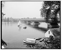
313:. Partly rebuilt after a spring freshet in 1818, Damon's bridge survived into the 20th century, and was the structure which the present concrete arch bridge was built to replace. The location of the 1814 bridge is marked by the position of "Bridge Street" in both Springfield and West Springfield, at approximately
385:
By the 1990s, the concrete above the arches was suffering from advanced Alkali-Silica
Reactivity (ASR) attack. The 1996 rehabilitation project replaced the entire deck system. The decorative architectural elements were replaced either in kind using cast stone or replaced with architectural fiberglass
352:
98,030,000 with inflation)) was let to H.P. Converse on April 3, 1920; the completed bridge was opened to traffic on August 3, 1922. At the ceremonies held that day, the bridge was dedicated as a memorial to "those who had died as pioneers, and soldiers in the
Revolutionary, Civil and Foreign Wars."
368:
The
Memorial Bridge features a seven-span, reinforced-concrete deck rib arches, with a nine-span reinforced concrete slab viaduct. Each of the river spans is made up of five Melan-type, two-hinged, reinforced-concrete arch ribs of parabolic profile. The bridge's longest ribs have a center to center
376:
The 1922 Memorial Bridge includes the longest single concrete arch span in
Massachusetts. Its self-supporting steel rib arches represent an uncommon refinement of Melan's original idea – by making the steel arches self-supporting, and using them to support their own load plus the weight of the
347:
In 1915, the
Hampden County Commissioners opened hearings to discuss construction of a new bridge, but it wasn't until the winter of 1918/19 that the location and overall design of the present concrete arch bridge were finally agreed upon. The main construction contract (at $ 3,254,883
452:
This ended travel across the bridge; and it was soon taken down, having become too much weather-beaten to endure longer service. It was mongrel in style, the travel being on neither the bottom nor top of the chord, but ascending and descending with the curve of the arches of each
372:
There were two gargoyles above the bridge on the south side that were removed when the bridge was upgraded several years ago. The four plaques on the central towers honor the original colonists, and veterans of the
American Revolutionary War, American Civil War, and World War I.
398:
670:
301:
The
Connecticut River was first bridged at Springfield in 1805, by an open wooden bridge said to have been "mongrel in style." It collapsed in 1814 and was replaced by a covered wooden
777:
747:
767:
719:
578:
782:
472:
How Much Is That in Real Money? A Historical Price Index for Use as a
Deflator of Money Values in the Economy of the United States: Addenda et Corrigenda
691:
636:
792:
772:
807:
59:
802:
17:
797:
762:
306:
507:
316:
742:
752:
603:
403:
492:
How Much Is That in Real Money? A Historical Price Index for Use as a
Deflator of Money Values in the Economy of the United States
787:
360:, with Haven & Hoyt, architects. When the bridge was refurbished in 1992, Fay Spofford & Thorndike was again involved.
528:
386:
reproductions. The viaduct over the railroad was replaced with adjacent precast/prestressed deck beams made continuous.
757:
582:
620:
278:
131:
727:
641:
Hampden County
Memorial Bridge, Spanning Connecticut River on Memorial Drive, Springfield, Hampden County, MA
499:
479:
357:
52:
141:
310:
274:
127:
445:
282:
281:, constructed in 1922. The bridge is owned by Massachusetts Highway Department and is located on
102:
625:
490:
470:
349:
8:
564:
288:
399:
List of bridges documented by the Historic American Engineering Record in Massachusetts
653:
646:
597:
546:
270:
113:
285:. It spans 209 feet (64 m) and rises 29.71 feet (9.06 m) above the river.
529:
Memorial Bridge - Springfield/West Springfield, MA - Arch Bridges on Waymarking.com
486:
466:
450:. Boston: James D. Gill; Franklin Press of Rand, Avery, & Company. p. 74.
41:
736:
723:
331:
318:
74:
61:
540:
431:
Dedication of the Hampden County Memorial Bridge, Thursday, August 3, 1922
266:
157:
640:
630:
302:
545:. Springfield, Massachusetts: F. A. Bassette Company. p. 99.
643:", 13 photos, 14 data pages, 1 photo caption page
550:
541:
Swift, Esther M.; West Springfield Heritage Association (1969).
681:
505:
389:
This project was completed by Daniel O'Connell's Sons in 1996.
117:
296:
778:
Massachusetts populated places on the Connecticut River
696:
748:
Buildings and structures in Springfield, Massachusetts
651:
768:
Historic American Engineering Record in Massachusetts
734:
543:West Springfield Massachusetts: A Town History
380:
565:"Memorial Bridge, Springfield, Massachusetts"
521:
447:King's handbook of Springfield, Massachusetts
783:Springfield metropolitan area, Massachusetts
621:Massachusetts Highway Department bridge data
27:Bridge in to West Springfield, Massachusetts
671:CSX Berkshire rail bridge (Springfield, MA)
458:
404:List of crossings of the Connecticut River
292:The 1818 bridge as it appeared around 1908
793:Bridges in Hampden County, Massachusetts
773:Monuments and memorials in Massachusetts
485:
465:
433:. Hampden County (Mass.): Commissioners.
287:
808:Burr Truss bridges in the United States
508:"Consumer Price Index (estimate) 1800–"
425:
423:
421:
419:
14:
735:
602:: CS1 maint: archived copy as title (
297:History and construction of the bridge
803:Concrete bridges in the United States
650:
506:Federal Reserve Bank of Minneapolis.
226:H. P. Converse & Co., Contractors
798:Former toll bridges in Massachusetts
763:1922 establishments in Massachusetts
718:This article incorporates text from
637:Historic American Engineering Record
443:
416:
24:
743:Bridges over the Connecticut River
25:
819:
753:Arch bridges in the United States
614:
94:pedestrian and vehicular traffic
711:
695:
680:
527:Arch Bridges on Waymarking.com:
142:Massachusetts Highway Department
97:
40:
279:West Springfield, Massachusetts
132:West Springfield, Massachusetts
571:
557:
534:
437:
259:Hampden County Memorial Bridge
34:Hampden County Memorial Bridge
18:Hampden County Memorial Bridge
13:
1:
788:Road bridges in Massachusetts
728:Commonwealth of Massachusetts
662:
409:
214:Adam & Buxton Constr. Co.
204:Fay, Spofford & Thorndike
500:American Antiquarian Society
480:American Antiquarian Society
358:Fay Spofford & Thorndike
7:
531:, accessdate: March 4, 2017
392:
381:1996 rehabilitation project
356:The bridge was designed by
265:) is a reinforced-concrete
263:Springfield Memorial Bridge
10:
824:
311:Northampton, Massachusetts
275:Springfield, Massachusetts
261:(sometimes referred to as
128:Springfield, Massachusetts
758:Bridges completed in 1922
686:
675:
665:
660:
639:(HAER) No. MA-114, "
444:King, Moses, ed. (1884).
363:
251:
246:
238:
230:
220:
208:
200:
192:
187:
179:
171:
163:
152:
147:
137:
123:
109:
90:
51:
39:
32:
332:42.100131°N 72.596245°W
283:Massachusetts Route 147
212:Daniel O'Connell's Sons
175:82.5 feet (25.1 m)
167:1,515 feet (462 m)
626:Memorial Bridge (1922)
293:
337:42.100131; -72.596245
291:
209:Engineering design by
75:42.09889°N 72.59500°W
183:209 feet (64 m)
156:reinforced-concrete
328: /
80:42.09889; -72.59500
71: /
294:
231:Construction start
708:
707:
703:
702:
654:Connecticut River
652:Crossings of the
567:. 7 October 2002.
271:Connecticut River
255:
254:
114:Connecticut River
16:(Redirected from
815:
715:
714:
699:
692:South End Bridge
684:
663:
648:
647:
608:
607:
601:
593:
591:
590:
581:. Archived from
575:
569:
568:
561:
555:
554:
538:
532:
525:
519:
518:
516:
514:
503:
497:
483:
477:
462:
456:
455:
441:
435:
434:
427:
343:
342:
340:
339:
338:
333:
329:
326:
325:
324:
321:
305:bridge built by
223:
216:George W. Hayden
196:Haven & Hoyt
101:
100:
86:
85:
83:
82:
81:
76:
72:
69:
68:
67:
64:
44:
30:
29:
21:
823:
822:
818:
817:
816:
814:
813:
812:
733:
732:
712:
709:
704:
694:
690:
679:
677:Memorial Bridge
673:
669:
656:
617:
612:
611:
595:
594:
588:
586:
579:"Archived copy"
577:
576:
572:
563:
562:
558:
539:
535:
526:
522:
512:
510:
495:
487:McCusker, J. J.
475:
467:McCusker, J. J.
463:
459:
442:
438:
429:
428:
417:
412:
395:
383:
366:
336:
334:
330:
327:
322:
319:
317:
315:
314:
303:Burr arch-truss
299:
269:that spans the
221:
215:
213:
148:Characteristics
98:
95:
79:
77:
73:
70:
65:
62:
60:
58:
57:
47:
46:Memorial Bridge
35:
28:
23:
22:
15:
12:
11:
5:
821:
811:
810:
805:
800:
795:
790:
785:
780:
775:
770:
765:
760:
755:
750:
745:
706:
705:
701:
700:
685:
674:
661:
658:
657:
645:
644:
634:
623:
616:
615:External links
613:
610:
609:
570:
556:
533:
520:
504:1800–present:
457:
436:
414:
413:
411:
408:
407:
406:
401:
394:
391:
382:
379:
365:
362:
298:
295:
253:
252:
249:
248:
244:
243:
240:
236:
235:
232:
228:
227:
224:
222:Constructed by
218:
217:
210:
206:
205:
202:
198:
197:
194:
190:
189:
185:
184:
181:
177:
176:
173:
169:
168:
165:
161:
160:
154:
150:
149:
145:
144:
139:
135:
134:
125:
121:
120:
111:
107:
106:
103:Route 147
92:
88:
87:
55:
49:
48:
45:
37:
36:
33:
26:
9:
6:
4:
3:
2:
820:
809:
806:
804:
801:
799:
796:
794:
791:
789:
786:
784:
781:
779:
776:
774:
771:
769:
766:
764:
761:
759:
756:
754:
751:
749:
746:
744:
741:
740:
738:
731:
730:
729:
725:
724:public domain
721:
698:
693:
689:
683:
678:
672:
668:
664:
659:
655:
649:
642:
638:
635:
633:
632:
627:
624:
622:
619:
618:
605:
599:
585:on 2016-03-04
584:
580:
574:
566:
560:
552:
548:
544:
537:
530:
524:
509:
501:
494:
493:
488:
481:
474:
473:
468:
461:
454:
449:
448:
440:
432:
426:
424:
422:
420:
415:
405:
402:
400:
397:
396:
390:
387:
378:
374:
370:
361:
359:
354:
351:
345:
341:
312:
308:
304:
290:
286:
284:
280:
276:
272:
268:
264:
260:
250:
245:
241:
237:
233:
229:
225:
219:
211:
207:
203:
199:
195:
191:
186:
182:
178:
174:
170:
166:
162:
159:
155:
151:
146:
143:
140:
138:Maintained by
136:
133:
129:
126:
122:
119:
115:
112:
108:
104:
93:
89:
84:
56:
54:
50:
43:
38:
31:
19:
726:work of the
717:
710:
687:
676:
666:
629:
587:. Retrieved
583:the original
573:
559:
542:
536:
523:
513:February 29,
511:. Retrieved
491:
471:
460:
451:
446:
439:
430:
388:
384:
375:
371:
367:
355:
346:
300:
262:
258:
256:
180:Longest span
164:Total length
484:1700–1799:
464:1634–1699:
335: /
307:Isaac Damon
267:arch bridge
158:arch bridge
78: /
53:Coordinates
737:Categories
688:Downstream
631:Structurae
589:2022-07-13
410:References
323:72°35′46″W
320:42°06′00″N
242:1922, 1996
66:72°35′42″W
63:42°05′56″N
193:Architect
667:Upstream
598:cite web
551:77-96767
489:(1992).
469:(1997).
393:See also
273:between
247:Location
201:Designer
720:MassDOT
188:History
110:Crosses
91:Carries
716:
549:
364:Design
239:Opened
153:Design
124:Locale
118:Amtrak
496:(PDF)
476:(PDF)
453:span.
172:Width
130:, to
722:, a
604:link
547:LCCN
515:2024
350:US$
277:and
257:The
234:1920
628:at
309:of
739::
600:}}
596:{{
498:.
478:.
418:^
344:.
116:,
606:)
592:.
553:.
517:.
502:.
482:.
348:(
105:)
96:(
20:)
Text is available under the Creative Commons Attribution-ShareAlike License. Additional terms may apply.

