245:
281:
299:
39:
257:
491:
269:
153:, accessible by a track 16 kilometres (9.9 mi) to the east. The visitors' book contains entries from the original team who identified the crater. This meteorite explosion crater is one of only 15 known worldwide, and only 3 in Western Australia. A good description can be found in the Australian Government Heritage site.
831:
204:
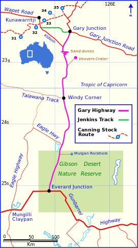
The approximate length of the track is 425 kilometres (264 mi), including side trips to
Veevers Crater and McPhersons Pillar. It is very remote with both ends being hundreds of kilometres from any settlements or supply points. An
856:
182:
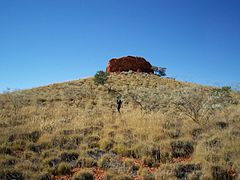
The Gibson Desert Nature
Reserve, which includes McPhersons Pillar. This is 30 km off the track but is a spectacular landmark with excellent views over the Gibson Desert and access to Mulgan Rockhole.
826:
197:
The track is single lane, relatively clear of scrub, but corrugated over its entire length. It is mostly straight, except for a section from 22.85°S to 22.88°S where the track diverts around
446:
213:
should be carried as there are no facilities along this track and travellers should be self-sufficient in fuel, food, water and vehicle support. The nearest northern supplies are at
159:, with several marker signs in different places, due to the shift of the tropics over time caused by the varying tilt of the Earth's axis, relative to its orbital plane.
861:
836:
841:
821:
851:
439:
901:
432:
201:. It was navigable (Sep 2007) with a hard surface of sand and gravel. The southern end has several wash-aways in the Gibson Desert Nature Reserve.
846:
896:
134:
at Gary
Junction in the north. It is one of only two north-south tracks in the central deserts of Western Australia, the other being the
214:
868:
813:
356:
179:
Patience Well, a well visited and named by David
Carnegie in 1896, 15.2 kilometres (9.4 mi) to the east of Windy Corner.
906:
873:
173:
McDougall Knoll, which is a good lookout point. There are notes from visitors contained in a tin can jammed in the cairn.
372:
280:
244:
412:
123:
611:
636:
331:
225:
on the Gary
Junction Road, or to the south some 300 kilometres (190 mi) south east of Everard Junction at
524:
377:
226:
126:
in April and May 1963 and named after
Beadell's son, who was born in February that year. It connects the
787:
681:
146:
The Gary
Highway passes several interesting points in its 323-kilometre (201 mi) desert crossing:
135:
671:
565:
303:
686:
656:
651:
530:
256:
701:
646:
550:
520:
470:
382:
727:
666:
424:
268:
8:
737:
696:
218:
156:
772:
762:
747:
661:
641:
606:
131:
115:
777:
742:
456:
408:
352:
327:
127:
107:
29:
373:"Veevers Meteorite Crater, Gary Junction via Telfer, WA, Australia (Place ID 18170)"
711:
596:
591:
555:
510:
480:
230:
767:
732:
691:
631:
616:
601:
515:
475:
210:
792:
782:
581:
560:
505:
163:
150:
176:
The junction of the Eagle
Highway, which is very overgrown most of its length.
63:
890:
706:
676:
621:
586:
535:
111:
298:
166:. The origins of the name "Windy Corner" can be read in Beadell's 1983 book
626:
540:
188:
Everard
Junction on the Gunbarrel Highway, where there is a visitors book.
797:
752:
545:
222:
119:
86:
38:
198:
206:
490:
454:
324:
A Lifetime in the Bush:The biography of Len
Beadell
407:. New Holland Publishers (Australia). p. 98.
888:
351:(Map). Eight Mile Plains Queensland: Hema Maps.
440:
162:Windy Corner, the junction at the end of the
402:
902:Tracks in remote areas of Western Australia
130:from Everard Junction in the south, to the
447:
433:
37:
349:Australia’s Great Desert Tracks NW Sheet
321:
889:
286:A panorama of Veevers Meteorite Crater
106:is a remote unsealed track in central
428:
315:
141:
371:
346:
897:Highways in rural Western Australia
13:
250:Gary Highway from Everard Junction
14:
918:
124:Gunbarrel Road Construction Party
46:Gary Highway in Western Australia
489:
297:
279:
267:
255:
243:
396:
365:
340:
192:
1:
308:
138:, also built by Len Beadell.
612:Coolgardie–Esperance Highway
378:Australian Heritage Database
326:. Adelaide: Corkwood Press.
7:
637:Geraldton–Mount Magnet Road
304:Australian Roads portal
291:
10:
923:
907:Roads built by Len Beadell
788:Sandy Blight Junction Road
682:North West Coastal Highway
236:
136:Sandy Blight Junction Road
16:Track in Western Australia
806:
720:
672:Manuwarra Red Dog Highway
574:
498:
487:
463:
92:
82:
77:
73:323 km (201 mi)
69:
59:
54:
50:
45:
36:
23:
575:Highways and major roads
455:Road infrastructure in
322:Shephard, Mark (1998).
657:Great Southern Highway
652:Great Northern Highway
531:Great Northern Highway
702:South Western Highway
647:Great Eastern Highway
551:South Western Highway
521:Great Eastern Highway
499:Metropolitan highways
471:Graham Farmer Freeway
403:Beadell, Len (1983).
383:Australian Government
827:Goldfields–Esperance
728:Anne Beadell Highway
667:Mandjoogoordap Drive
217:near Well 33 on the
110:running through the
738:Canning Stock Route
697:South Coast Highway
347:Hema, Maps (2005).
227:Warburton Roadhouse
219:Canning Stock Route
157:Tropic of Capricorn
118:. It was built by
55:General information
773:Great Central Road
763:Gary Junction Road
748:Connie Sue Highway
662:Indian Ocean Drive
642:Goldfields Highway
566:West Coast Highway
142:Points of interest
132:Gary Junction Road
116:Great Sandy Desert
884:
883:
778:Gunbarrel Highway
743:Cape Leveque Road
457:Western Australia
358:978-1-86500-159-3
262:McPhersons Pillar
128:Gunbarrel Highway
108:Western Australia
100:
99:
30:Western Australia
914:
712:Victoria Highway
597:Brookton Highway
592:Brockman Highway
556:Stirling Highway
511:Brookton Highway
493:
481:Mitchell Freeway
449:
442:
435:
426:
425:
419:
418:
400:
394:
393:
391:
389:
369:
363:
362:
344:
338:
337:
319:
302:
301:
283:
271:
259:
247:
231:Carnegie Station
41:
21:
20:
922:
921:
917:
916:
915:
913:
912:
911:
887:
886:
885:
880:
802:
768:Gibb River Road
733:Buntine Highway
716:
692:Robertson Drive
632:Forrest Highway
617:Dampier Highway
607:Coalfields Road
602:Bussell Highway
570:
516:Canning Highway
494:
485:
476:Kwinana Freeway
459:
453:
423:
422:
415:
401:
397:
387:
385:
370:
366:
359:
345:
341:
334:
320:
316:
311:
296:
294:
287:
284:
275:
274:Mulgan Rockhole
272:
263:
260:
251:
248:
239:
211:satellite phone
195:
144:
32:
27:
26:
17:
12:
11:
5:
920:
910:
909:
904:
899:
882:
881:
879:
878:
877:
876:
874:Tourist Drives
866:
865:
864:
859:
854:
849:
844:
839:
834:
832:Great Southern
829:
824:
816:
810:
808:
804:
803:
801:
800:
795:
793:Talawana Track
790:
785:
783:Kalumburu Road
780:
775:
770:
765:
760:
755:
750:
745:
740:
735:
730:
724:
722:
721:Outback tracks
718:
717:
715:
714:
709:
704:
699:
694:
689:
687:Old Coast Road
684:
679:
674:
669:
664:
659:
654:
649:
644:
639:
634:
629:
624:
619:
614:
609:
604:
599:
594:
589:
584:
582:Albany Highway
578:
576:
572:
571:
569:
568:
563:
561:Tonkin Highway
558:
553:
548:
543:
538:
533:
528:
518:
513:
508:
506:Albany Highway
502:
500:
496:
495:
488:
486:
484:
483:
478:
473:
467:
465:
461:
460:
452:
451:
444:
437:
429:
421:
420:
413:
395:
364:
357:
339:
332:
313:
312:
310:
307:
293:
290:
289:
288:
285:
278:
276:
273:
266:
264:
261:
254:
252:
249:
242:
238:
235:
194:
191:
190:
189:
186:
185:Charlies Knob.
183:
180:
177:
174:
171:
164:Talawana Track
160:
154:
151:Veevers crater
143:
140:
98:
97:
94:
90:
89:
84:
80:
79:
75:
74:
71:
67:
66:
61:
57:
56:
52:
51:
48:
47:
43:
42:
34:
33:
28:
24:
15:
9:
6:
4:
3:
2:
919:
908:
905:
903:
900:
898:
895:
894:
892:
875:
872:
871:
870:
867:
863:
860:
858:
855:
853:
850:
848:
845:
843:
840:
838:
835:
833:
830:
828:
825:
823:
820:
819:
817:
815:
812:
811:
809:
805:
799:
796:
794:
791:
789:
786:
784:
781:
779:
776:
774:
771:
769:
766:
764:
761:
759:
756:
754:
751:
749:
746:
744:
741:
739:
736:
734:
731:
729:
726:
725:
723:
719:
713:
710:
708:
707:Vasse Highway
705:
703:
700:
698:
695:
693:
690:
688:
685:
683:
680:
678:
677:Muirs Highway
675:
673:
670:
668:
665:
663:
660:
658:
655:
653:
650:
648:
645:
643:
640:
638:
635:
633:
630:
628:
625:
623:
622:Derby Highway
620:
618:
615:
613:
610:
608:
605:
603:
600:
598:
595:
593:
590:
588:
587:Brand Highway
585:
583:
580:
579:
577:
573:
567:
564:
562:
559:
557:
554:
552:
549:
547:
544:
542:
539:
537:
536:Leach Highway
534:
532:
529:
526:
522:
519:
517:
514:
512:
509:
507:
504:
503:
501:
497:
492:
482:
479:
477:
474:
472:
469:
468:
466:
462:
458:
450:
445:
443:
438:
436:
431:
430:
427:
416:
414:1-86436-733-4
410:
406:
405:End of an Era
399:
384:
380:
379:
374:
368:
360:
354:
350:
343:
335:
329:
325:
318:
314:
306:
305:
300:
282:
277:
270:
265:
258:
253:
246:
241:
240:
234:
233:to the west.
232:
228:
224:
220:
216:
212:
208:
202:
200:
187:
184:
181:
178:
175:
172:
169:
168:End Of An Era
165:
161:
158:
155:
152:
149:
148:
147:
139:
137:
133:
129:
125:
121:
117:
113:
112:Gibson Desert
109:
105:
95:
91:
88:
85:
81:
76:
72:
68:
65:
62:
58:
53:
49:
44:
40:
35:
31:
22:
19:
818:Major roads
758:Gary Highway
757:
627:Eyre Highway
541:Reid Highway
404:
398:
386:. Retrieved
376:
367:
348:
342:
323:
317:
295:
215:Kunawarritji
203:
196:
167:
145:
104:Gary Highway
103:
101:
78:Restrictions
25:Gary Highway
18:
869:Road routes
798:Tanami Road
753:Duncan Road
546:Roe Highway
223:Kiwirrkurra
193:Description
120:Len Beadell
87:Kunawaritji
83:Fuel supply
891:Categories
857:South West
388:31 October
333:1876247053
309:References
199:sand dunes
93:Facilities
862:Wheatbelt
837:Kimberley
842:Mid West
822:Gascoyne
814:Highways
464:Freeways
292:See also
207:HF radio
114:and the
852:Pilbara
237:Gallery
525:Bypass
411:
355:
330:
70:Length
847:Perth
807:Lists
64:Track
409:ISBN
390:2008
353:ISBN
328:ISBN
221:and
102:The
96:None
60:Type
229:or
209:or
122:'s
893::
381:.
375:.
527:)
523:(
448:e
441:t
434:v
417:.
392:.
361:.
336:.
170:.
Text is available under the Creative Commons Attribution-ShareAlike License. Additional terms may apply.


