570:
996:
609:
91:
1016:"}},"text\/plain":{"en":{"":"determination method"}}},"{\"value\":{\"entity-type\":\"item\",\"numeric-id\":60671452,\"id\":\"Q60671452\"},\"type\":\"wikibase-entityid\"}":{"text\/html":{"en":{"P459":"
1012:"}},"text\/plain":{"en":{"P1001":"United States of America"}}},"{\"value\":{\"entity-type\":\"property\",\"numeric-id\":459,\"id\":\"P459\"},\"type\":\"wikibase-entityid\"}":{"text\/html":{"en":{"":"
1096:"}},"text\/plain":{"en":{"":"media type"}}},"{\"value\":\"image\\\/jpeg\",\"type\":\"string\"}":{"text\/html":{"en":{"P1163":"image\/jpeg"}},"text\/plain":{"en":{"P1163":"image\/jpeg"}}}}": -->
1008:"}},"text\/plain":{"en":{"":"applies to jurisdiction"}}},"{\"value\":{\"entity-type\":\"item\",\"numeric-id\":30,\"id\":\"Q30\"},\"type\":\"wikibase-entityid\"}":{"text\/html":{"en":{"P1001":"
1000:"}},"text\/plain":{"en":{"":"copyright status"}}},"{\"value\":{\"entity-type\":\"item\",\"numeric-id\":19652,\"id\":\"Q19652\"},\"type\":\"wikibase-entityid\"}":{"text\/html":{"en":{"P6216":"
43:
1004:"}},"text\/plain":{"en":{"P6216":"public domain"}}},"{\"value\":{\"entity-type\":\"property\",\"numeric-id\":1001,\"id\":\"P1001\"},\"type\":\"wikibase-entityid\"}":{"text\/html":{"en":{"":"
953:"}},"text\/plain":{"en":{"":"depicts"}}},"{\"value\":{\"entity-type\":\"item\",\"numeric-id\":2140450,\"id\":\"Q2140450\"},\"type\":\"wikibase-entityid\"}":{"text\/html":{"en":{"P180":"
1092:
243:
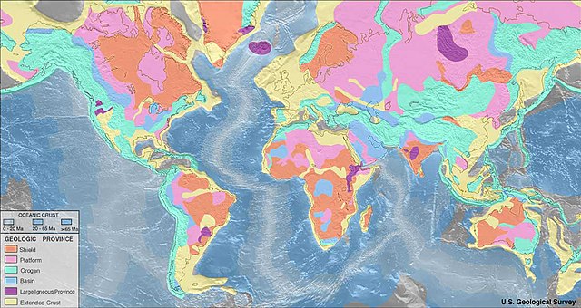
Important note: These geologic province map renders only features approximately 150 km across and greater due to the fact that the resolution of the maps should be consistent with the resolution of the seismic refraction data. For example, the young uplifted blocks of the
Variscan Orogen in Central
333:
Hinweis: Diese Karte führt nur
Einheiten, deren Ausbissfläche einen Durchmesser von mindestens 150 km besitzt. Beispielsweise sind die jung herausgehobenen Schollen des Variszischen Orogens in Mittel- und Westeuropa, wie z.B. die Rheinische Masse oder das französische Zentralmassiv, nicht als
515:
Nota important: Aquests mapes de regions geològiques només representen característiques d'aproximadament 150 km de diàmetre i més a causa del fet que la resolució dels mapes hauria de ser coherent amb la resolució de les dades de refracció sísmica. Per exemple, els blocs joves aixecats de
1716:
367:
419:< Σημαντική σημείωση: Αυτός ο γεωλογικός χάρτης αποδίδει μόνο δομές μεγέθους 150 χλμ. και πάνω λόγω του ότι η ανάλυση των χαρτών πρέπει να είναι συνεπής με την ανάλυση των σεισμικών δεδομένων διάθλασης.
1621:
520:
a l'Europa central i occidental, com el massís renà o el massís central, no es representen com a "orògens", sinó com a part de l'"escorça continental estesa" a la meitat occidental d'Europa.
1646:
376:
244:
and
Western Europe such as the Rhenish Massif or the Massif Central are not depicted as ‘orogens’ but as part of the ‘extended continental crust’ in the western half of Europe.
1017:
954:
348:
1182:
1001:
356:
1093:
1005:
997:
1616:
1013:
950:
1009:
564:
1631:
132:
1691:
1905:
126:
397:
391:
1866:
1861:
1020:"}},"text\/plain":{"en":{"P459":"work of the federal government of the United States"}}}}": -->
1871:
57:
53:
47:
1503:
627:
102:
70:
1078:
1641:
1581:
983:
1313:
545:
1916:
This file contains additional information, probably added from the digital camera or scanner used to create or digitize it.
1696:
1636:
1606:
1043:
1103:
1056:
1027:
364:
1611:
1071:
967:
334:„phanerozoische Orogene“, sondern als Teil der „gedehnten kontinentalen Kruste“ in der Westhälfte Europas dargestellt.
1543:
1063:
631:
1508:
623:
476:
1676:
1706:
1328:
1919:
If the file has been modified from its original state, some details may not fully reflect the modified file.
294:
1523:
1463:
893:
1601:
1413:
957:"}},"text\/plain":{"en":{"P180":"geologic province"}}}}": -->
1796:
1553:
429:
1666:
1219:
The following pages on the
English Knowledge use this file (pages on other projects are not listed):
484:
1896:
1681:
569:
490:
448:
1513:
204:
110:
517:
1548:
1483:
1238:
303:
1626:
1591:
1171:
1166:
61:
42:
1876:
1538:
1518:
176:
1233:
308:
286:
266:
258:
546:
https://web.archive.org/web/20150203073142/https://earthquake.usgs.gov/data/crust/maps.php
8:
1533:
1448:
1323:
1278:
467:
440:
1358:
499:
130:
can overwrite this file from the same source. Please ensure that overwrites comply with
1886:
1453:
1423:
1408:
1373:
1318:
1258:
1223:
1194:
161:
622:
in the United States because it only contains materials that originally came from the
1493:
1428:
1378:
1363:
1338:
1308:
1248:
1228:
1190:
168:
97:
1478:
1283:
1473:
1468:
1458:
1418:
1403:
1388:
1293:
1288:
274:
213:
196:
541:
459:
1686:
1498:
1443:
1353:
1298:
1243:
317:
1786:
865:
856:
456:
1806:
1433:
1383:
1368:
1263:
618:
218:
531:
1488:
1393:
1343:
1202:
757:
1596:
1438:
1348:
1333:
1303:
1268:
1206:
883:
874:
847:
838:
829:
820:
811:
802:
793:
784:
775:
766:
748:
739:
730:
721:
712:
703:
694:
685:
676:
667:
658:
649:
640:
277:
184:
1776:
1113:
1037:
977:
436:
227:
1528:
1841:
1139:
Click on a date/time to view the file as it appeared at that time.
187:
1756:
1571:
1398:
1273:
1761:
1253:
1198:
1851:
1836:
1731:
1766:
1826:
1656:
85:
1821:
1751:
927:
Add a one-line explanation of what this file represents
1736:
1746:
1217:
1897:
User:Marshallsumter/Keynote lectures (draft)/Geology
1562:
1137:
109:
Commons is a freely licensed media file repository.
1846:
1831:
1816:
1781:
1726:
1079:
work of the federal government of the United States
1018:
work of the federal government of the United States
530:original upload english wikipedia 22 April 2005 by
75:(1,200 × 637 pixels, file size: 115 KB, MIME type:
565:World geologic provinces North America cropped.png
542:https://earthquake.usgs.gov/data/crust/maps.php
90:
526:
147:
1197:* Platform (shield covered with sediment) *
559:
551:
537:
14:
943:Mapa de les regions geològiques de la terra
253:Karte der geologischen Provinzen der Erde.
1887:High School Earth Science/Topographic Maps
1564:The following other wikis use this file:
1504:Talk:Abiogenic petroleum origin/Archive 1
1193:. Geologic provinces based on origin: *
628:United States Department of the Interior
608:
563:Derivative works of this file:
121:
603:
1209:province * Extended [[Crust (geolog
1130:
13:
1914:
1807:Bruger:Palnatoke/Autolister/Modsat
948:
942:
934:
926:
901:
632:the official USGS copyright policy
614:
422:
337:
285:Vorland- oder „intrakratonisches“
247:
154:
122:
68:
1940:
1921:
1663:Usage on be-tarask.wikipedia.org
1544:Template:World geologic provinces
1314:Glossary of geography terms (N–Z)
947:
1509:Talk:Outline of physical science
1218:
917:
607:
568:
89:
31:
21:
935:Map of world geologic provinces
914:
624:United States Geological Survey
423:
155:
1617:مستخدم:NEHAOUA/منصة (جيولوجيا)
1559:
1134:
913:
470:d'avantpaís o intracratòniques
343:Παγκόσμιος Γεωλογικός Χάρτης
248:
26:
1:
1622:قالب:أقاليم العالم الجيولوجية
1329:Hallandian-Danopolonian event
866:
857:
630:. For more information, see
338:
36:
1893:Usage on en.wikiversity.org
1524:User:Northamerica1000/Topics
1464:Sethunathasarma Krishnaswami
1214:
963:Items portrayed in this file
579:
150:World geologic provinces.jpg
7:
1911:
1703:Usage on blk.wikipedia.org
1653:Usage on ast.wikipedia.org
1578:Usage on anp.wikipedia.org
384:Μεγάλες πυριγενείς περιοχές
10:
1945:
1883:Usage on en.wikibooks.org
1858:Usage on el.wikipedia.org
1813:Usage on de.wikipedia.org
1803:Usage on da.wikipedia.org
1793:Usage on cv.wikipedia.org
1773:Usage on cs.wikipedia.org
1743:Usage on ca.wikipedia.org
1723:Usage on bs.wikipedia.org
1713:Usage on bn.wikipedia.org
1673:Usage on bg.wikipedia.org
1588:Usage on ar.wikipedia.org
1568:Usage on af.wikipedia.org
195:Foreland or intracratonic
144:
139:
1787:Východoevropská platforma
1647:الخطوط العريضة للجيولوجيا
1554:Portal:Maps/Maps/World/20
1414:Paraná and Etendeka traps
1131:
758:
295:Magmatische Großprovinzen
16:
1064:United States of America
1010:United States of America
916:
884:
875:
848:
839:
830:
821:
812:
803:
794:
785:
776:
767:
749:
740:
731:
722:
713:
704:
695:
686:
677:
668:
659:
650:
641:
477:Gran província volcànica
390:Εκτεταμένος ηπειρωτικός
267:Kontinentale Plattformen
96:This is a file from the
41:
1842:Becken (Geomorphologie)
1514:User:Arthena/DE list 68
1188:
1167:02:27, 3 September 2005
1057:applies to jurisdiction
1006:applies to jurisdiction
529:
100:. Information from its
1549:Portal:Maps/Maps/World
1484:Transamazonian orogeny
1239:Central Plains orogeny
906:
205:Large igneous province
103:description page there
46:Size of this preview:
1632:مصاطب بارانا وإتنديكا
1539:Template:Orogeny-stub
1519:User:DFRussia/PSciAlt
905:
616:This image is in the
457:Cadenes orogenèniques
449:Platforma continental
259:Präkambrische Schilde
212:Extended continental
1717:ভূতাত্ত্বিক মানচিত্র
1692:Платформа (геология)
1572:Geologiese provinsie
1234:Borchgrevink orogeny
1184:Saperaud~commonswiki
1072:determination method
1014:determination method
1534:User:SEWilco/Images
1449:Sampat Kumar Tandon
1324:Great Falls orogeny
1279:Early Ruker orogeny
626:, an agency of the
518:Orogenia herciniana
485:Escorça continental
430:regions geològiques
304:kontinentale Kruste
52:Other resolutions:
1872:Τράπεζα (γεωλογία)
1454:San Rafael orogeny
1424:Platform (geology)
1409:Outline of geology
1374:Late Ruker orogeny
1319:Gondwanide orogeny
1284:Earth's crust
1259:Dabie-Sulu orogeny
1224:Barramundi orogeny
1191:geologic provinces
907:
544:archived version:
309:ozeanischen Kruste
162:geologic provinces
127:autoconfirmed user
62:1,200 × 637 pixels
1932:
1931:
1906:more global usage
1867:Γεωλογικός χάρτης
1862:Ηπειρωτική ασπίδα
1852:Schild (Geologie)
1837:Thematische Karte
1732:Pregled geologije
1642:درع (طبقات الأرض)
1560:Global file usage
1494:Upper mantle body
1429:Rangitata orogeny
1379:List of orogenies
1364:Kanimblan Orogeny
1339:Innuitian orogeny
1309:Geologic province
1249:Cimmerian Orogeny
1229:Beardmore orogeny
1212:
984:geologic province
955:geologic province
941:
933:
925:
911:
910:
896:
602:
601:
576:
575:
118:
117:
98:Wikimedia Commons
32:Global file usage
1936:
1922:
1767:Escut (geologia)
1757:Trapps del Dècan
1474:Structural basin
1469:Shield (geology)
1459:Scandian orogeny
1419:Penokean orogeny
1404:Ouachita orogeny
1389:Malagasy orogeny
1359:Kaikōura orogeny
1294:Elevation crater
1289:Eburnean orogeny
1179:
1141:
1081:
1076:
1066:
1061:
1028:copyright status
998:copyright status
939:
931:
923:
904:
897:
892:
642:Bahasa Indonesia
611:
610:
604:
598:
595:
592:
589:
584:
583:
572:
491:Escorça Oceànica
427:
342:
252:
159:
151:
145:
114:
93:
92:
86:
80:
78:
65:
58:640 × 340 pixels
54:320 × 170 pixels
48:800 × 425 pixels
1944:
1943:
1939:
1938:
1937:
1935:
1934:
1933:
1910:
1558:
1499:Uralian orogeny
1444:Samfrau Orogeny
1354:Ivanpah orogeny
1299:Eurekan orogeny
1244:Chonide orogeny
1220:
1213:
1185:
1177:
1133:
1132:
1129:
1128:
1127:
1126:
1125:
1124:
1123:
1122:
1120:
1110:
1109:
1108:
1106:
1091:
1090:
1089:
1088:
1087:
1086:
1085:
1084:
1083:
1082:
1077:
1074:
1068:
1067:
1062:
1059:
1050:
1049:
1048:
1046:
1034:
1033:
1032:
1030:
995:
994:
993:
992:
991:
990:
989:
988:
986:
974:
973:
972:
970:
946:
945:
944:
937:
936:
929:
928:
902:
886:
877:
868:
859:
850:
841:
832:
823:
814:
805:
796:
787:
778:
769:
760:
751:
742:
733:
724:
715:
706:
697:
688:
679:
670:
661:
652:
643:
639:
636:
596:
593:
590:
587:
582:
577:
521:
514:
512:
508:
506:
502:
497:
488:
483:
479:
475:
471:
466:
462:
455:
451:
447:
443:
435:
420:
418:
416:
412:
410:
406:
404:
398:Ωκεάνιου φλοιού
394:
389:
385:
383:
379:
374:
370:
363:
359:
355:
351:
347:
335:
332:
330:
326:
324:
320:
315:
306:
301:
297:
293:
289:
284:
280:
273:
269:
265:
261:
257:
245:
242:
240:
236:
234:
230:
225:
216:
211:
207:
203:
199:
194:
190:
183:
179:
175:
171:
167:
149:
142:
137:
120:
119:
108:
107:
106:is shown below.
82:
76:
74:
67:
66:
51:
12:
11:
5:
1942:
1930:
1929:
1926:
1913:
1908:of this file.
1902:
1901:
1900:
1899:
1891:
1890:
1889:
1881:
1880:
1879:
1874:
1869:
1864:
1856:
1855:
1854:
1849:
1844:
1839:
1834:
1829:
1824:
1819:
1811:
1810:
1809:
1801:
1800:
1799:
1791:
1790:
1789:
1784:
1779:
1771:
1770:
1769:
1764:
1759:
1754:
1749:
1741:
1740:
1739:
1734:
1729:
1721:
1720:
1719:
1711:
1710:
1709:
1701:
1700:
1699:
1697:Геоложка карта
1694:
1689:
1684:
1679:
1677:Щит (геология)
1671:
1670:
1669:
1661:
1660:
1659:
1651:
1650:
1649:
1644:
1639:
1637:القشرة الأرضية
1634:
1629:
1624:
1619:
1614:
1609:
1607:خريطة جيولوجية
1604:
1599:
1594:
1586:
1585:
1584:
1576:
1575:
1574:
1561:
1557:
1556:
1551:
1546:
1541:
1536:
1531:
1526:
1521:
1516:
1511:
1506:
1501:
1496:
1491:
1486:
1481:
1479:Sunsás orogeny
1476:
1471:
1466:
1461:
1456:
1451:
1446:
1441:
1436:
1434:Rayner orogeny
1431:
1426:
1421:
1416:
1411:
1406:
1401:
1396:
1391:
1386:
1384:Lopian orogeny
1381:
1376:
1371:
1369:Kuunga orogeny
1366:
1361:
1356:
1351:
1346:
1341:
1336:
1331:
1326:
1321:
1316:
1311:
1306:
1301:
1296:
1291:
1286:
1281:
1276:
1271:
1266:
1264:Damara orogeny
1261:
1256:
1251:
1246:
1241:
1236:
1231:
1226:
1216:
1211:
1210:
1187:
1183:
1180:
1174:
1169:
1164:
1160:
1159:
1156:
1153:
1150:
1147:
1144:
1136:
1121:
1118:
1116:
1115:
1114:
1112:
1111:
1107:
1102:
1100:
1099:
1098:
1097:
1095:
1070:
1069:
1055:
1054:
1053:
1052:
1051:
1047:
1042:
1040:
1039:
1038:
1036:
1035:
1031:
1026:
1024:
1023:
1022:
1021:
1019:
1015:
1011:
1007:
1003:
999:
987:
982:
980:
979:
978:
976:
975:
971:
966:
964:
961:
960:
959:
958:
956:
952:
938:
930:
922:
921:
918:
915:
909:
908:
899:
612:
600:
599:
581:
578:
574:
573:
561:
560:Other versions
557:
556:
553:
549:
548:
539:
535:
534:
528:
524:
523:
510:
509:
504:
503:
495:
494:
481:
480:
473:
472:
464:
463:
453:
452:
445:
444:
433:
432:
414:
413:
408:
407:
402:
401:
387:
386:
381:
380:
372:
371:
361:
360:
353:
352:
345:
344:
328:
327:
322:
321:
313:
312:
299:
298:
291:
290:
282:
281:
275:Phanerozoische
271:
270:
263:
262:
255:
254:
238:
237:
232:
231:
223:
222:
209:
208:
201:
200:
192:
191:
181:
180:
173:
172:
165:
164:
152:
143:
141:
138:
123:
116:
115:
94:
84:
83:
45:
40:
39:
34:
29:
24:
19:
9:
6:
4:
3:
2:
1941:
1927:
1924:
1923:
1920:
1917:
1909:
1907:
1898:
1895:
1894:
1892:
1888:
1885:
1884:
1882:
1878:
1875:
1873:
1870:
1868:
1865:
1863:
1860:
1859:
1857:
1853:
1850:
1848:
1845:
1843:
1840:
1838:
1835:
1833:
1830:
1828:
1825:
1823:
1820:
1818:
1815:
1814:
1812:
1808:
1805:
1804:
1802:
1798:
1795:
1794:
1792:
1788:
1785:
1783:
1780:
1778:
1775:
1774:
1772:
1768:
1765:
1763:
1762:Mapa geològic
1760:
1758:
1755:
1753:
1750:
1748:
1745:
1744:
1742:
1738:
1735:
1733:
1730:
1728:
1725:
1724:
1722:
1718:
1715:
1714:
1712:
1708:
1705:
1704:
1702:
1698:
1695:
1693:
1690:
1688:
1685:
1683:
1680:
1678:
1675:
1674:
1672:
1668:
1665:
1664:
1662:
1658:
1655:
1654:
1652:
1648:
1645:
1643:
1640:
1638:
1635:
1633:
1630:
1628:
1625:
1623:
1620:
1618:
1615:
1613:
1612:إقليم جيولوجي
1610:
1608:
1605:
1603:
1600:
1598:
1595:
1593:
1590:
1589:
1587:
1583:
1580:
1579:
1577:
1573:
1570:
1569:
1567:
1566:
1565:
1555:
1552:
1550:
1547:
1545:
1542:
1540:
1537:
1535:
1532:
1530:
1527:
1525:
1522:
1520:
1517:
1515:
1512:
1510:
1507:
1505:
1502:
1500:
1497:
1495:
1492:
1490:
1489:Tuhua orogeny
1487:
1485:
1482:
1480:
1477:
1475:
1472:
1470:
1467:
1465:
1462:
1460:
1457:
1455:
1452:
1450:
1447:
1445:
1442:
1440:
1437:
1435:
1432:
1430:
1427:
1425:
1422:
1420:
1417:
1415:
1412:
1410:
1407:
1405:
1402:
1400:
1397:
1395:
1394:Orogenic belt
1392:
1390:
1387:
1385:
1382:
1380:
1377:
1375:
1372:
1370:
1367:
1365:
1362:
1360:
1357:
1355:
1352:
1350:
1347:
1345:
1344:Insel orogeny
1342:
1340:
1337:
1335:
1332:
1330:
1327:
1325:
1322:
1320:
1317:
1315:
1312:
1310:
1307:
1305:
1302:
1300:
1297:
1295:
1292:
1290:
1287:
1285:
1282:
1280:
1277:
1275:
1272:
1270:
1267:
1265:
1262:
1260:
1257:
1255:
1252:
1250:
1247:
1245:
1242:
1240:
1237:
1235:
1232:
1230:
1227:
1225:
1222:
1221:
1208:
1204:
1200:
1196:
1192:
1189:Map of world
1186:
1181:
1175:
1173:
1170:
1168:
1165:
1162:
1161:
1157:
1154:
1151:
1148:
1145:
1143:
1142:
1140:
1117:
1105:
1101:
1080:
1073:
1065:
1058:
1045:
1044:public domain
1041:
1029:
1025:
1002:public domain
985:
981:
969:
965:
962:
919:
912:
900:
898:
895:
891:
887:
882:
878:
873:
869:
864:
860:
855:
851:
846:
842:
837:
833:
828:
824:
819:
815:
810:
806:
801:
797:
792:
788:
783:
779:
774:
770:
765:
761:
756:
752:
747:
743:
738:
734:
729:
725:
720:
716:
711:
707:
702:
698:
693:
689:
684:
680:
675:
671:
666:
662:
657:
653:
648:
644:
637:
634:
633:
629:
625:
621:
620:
619:public domain
613:
606:
605:
591:Public domain
588:Public domain
586:
585:
571:
566:
562:
558:
554:
550:
547:
543:
540:
536:
533:
525:
522:
519:
501:
492:
486:
478:
469:
461:
460:fanerozoiques
458:
450:
442:
438:
431:
426:
421:
400:
399:
393:
378:
369:
366:
358:
350:
341:
336:
319:
310:
305:
296:
288:
279:
276:
268:
260:
251:
246:
229:
220:
219:Oceanic crust
215:
206:
198:
189:
186:
178:
170:
163:
160:Map of world
158:
153:
146:
135:
134:
133:the guideline
129:
128:
112:
105:
104:
99:
95:
88:
87:
81:
72:
71:Original file
63:
59:
55:
49:
44:
38:
35:
33:
30:
28:
25:
23:
20:
18:
15:
1918:
1915:
1903:
1777:Baltský štít
1563:
1439:Ross orogeny
1349:Isan orogeny
1334:Igneous rock
1304:Geologic map
1269:Deccan Traps
1176:1,200 × 637
1138:
1135:File history
889:
880:
871:
862:
853:
844:
835:
826:
817:
808:
799:
790:
781:
772:
763:
754:
745:
736:
727:
718:
709:
700:
691:
682:
673:
664:
655:
646:
638:
617:
615:
428:Mapa de les
424:
395:
375:Ηπειρωτικές
368:Φανεροζωικού
339:
249:
156:
131:
125:
111:You can help
101:
69:
22:File history
1822:Meereskunde
1602:تكون الجبال
489:Edat de l'
185:Phanerozoic
148:Description
1925:_error
1827:Landfläche
1797:Тектогенез
1215:File usage
1152:Dimensions
1119:image/jpeg
1104:media type
1094:media type
804:македонски
777:Tiếng Việt
732:Nederlands
340:Ελληνικά:
307:Alter der
77:image/jpeg
27:File usage
1737:Orogeneza
1682:Орогенеза
1627:حوض بنيوي
1592:حوض رسوبي
1582:भूविज्ञान
1529:User:RAMA
1149:Thumbnail
1146:Date/Time
932:Ukrainian
795:български
759:sicilianu
741:português
580:Licensing
513:>65 Ma
417:>65 Ma
365:Ορογένεση
331:>65 Ma
302:Gedehnte
250:Deutsch:
241:>65 Ma
157:English:
1912:Metadata
1877:Κρατώνας
1747:Geologia
1667:Геалёгія
1657:Xeoloxía
1205:* Large
1178:(115 KB)
920:Captions
723:italiano
705:français
507:20–65 Ma
425:Català:
411:20–65 Ma
325:20–65 Ma
235:20–65 Ma
177:Platform
37:Metadata
1707:ဘူမိဗေဒ
1399:Orogeny
1274:Diamond
1207:igneous
1163:current
1158:Comment
968:depicts
951:depicts
940:Catalan
924:English
876:العربية
813:русский
696:español
687:English
669:Deutsch
660:čeština
567::
532:SEWilco
468:Conques
437:Cratons
405:0–20 Ma
396:Ηλικία
377:Λεκάνες
357:Τράπεζα
278:Orogene
217:Age of
140:Summary
73:
1847:Kraton
1832:Orogen
1817:Region
1782:Kraton
1727:Kraton
1687:Кратон
1254:Craton
1199:Orogen
1195:Shield
888:
879:
870:
867:中文(繁體)
861:
858:中文(简体)
852:
843:
834:
825:
822:മലയാളം
816:
807:
798:
789:
786:Türkçe
780:
771:
762:
753:
750:polski
744:
735:
726:
717:
714:galego
708:
699:
690:
681:
672:
663:
654:
651:català
645:
552:Author
538:Source
511:
505:
496:
487:extesa
482:
474:
465:
454:
446:
441:escuts
434:
415:
409:
403:
392:φλοιός
388:
382:
373:
362:
354:
349:Ασπίδα
346:
329:
323:
314:
300:
292:
287:Becken
283:
272:
264:
256:
239:
233:
224:
210:
202:
193:
188:orogen
182:
174:
169:Shield
166:
1904:View
1752:Crató
1597:منطقة
1203:Basin
885:فارسی
768:suomi
678:eesti
597:false
594:false
498:0–20
316:0–20
226:0–20
214:crust
197:Basin
1155:User
555:USGS
527:Date
124:Any
17:File
894:+/−
840:日本語
831:한국어
1201:*
1075::
1060::
849:中文
516:l'
500:Ma
493::
439:o
318:Ma
311::
228:Ma
221::
136:.
60:|
56:|
50:.
1928:0
890:∙
881:∙
872:∙
863:∙
854:∙
845:∙
836:∙
827:∙
818:∙
809:∙
800:∙
791:∙
782:∙
773:∙
764:∙
755:∙
746:∙
737:∙
728:∙
719:∙
710:∙
701:∙
692:∙
683:∙
674:∙
665:∙
656:∙
647:∙
635:.
113:.
79:)
64:.
Text is available under the Creative Commons Attribution-ShareAlike License. Additional terms may apply.
